Photo By John Taylor : John snapped this photo of a little but of snow that fell overnight up in the mountains as a cold front moved across the area. Thursday – April 1, 2021
Devils Knob – 3500′
Wintergreen Resort
Nelson County, Virginia
Yes, it’s officially spring and we’re not into April but in the mountains that really doesn’t matter for a few more weeks. Overnight as a sharp cold front moved across the area some light fluffy snow fell here in Nelson up in the higher elevations. Our weather buddy John Taylor grabbed the shot above this morning with a little light snow on his car. He tells us, “I’m guessing that it is wintry mix topped by a few flakes of snow. Temperature here now is 28.2.” That was around 7:40 Thursday morning.
Not to worry, if you are a warm weather lover, you will love next week! Check out Travis Koshko’s 7 day outlook. Real warmth by next week!
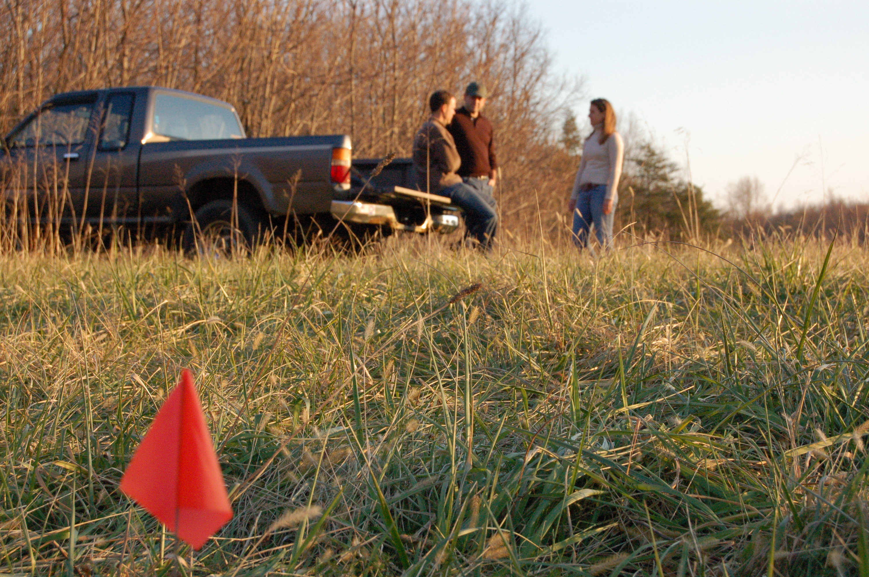
At 9:22 a.m. on Tuesday (March 30), Virginia State Police responded to a single-vehicle crash on westbound I-64 near the 87.8 mile marker.
A 2001 Kenworth T800 dump truck was traveling in the center lane when one of its tires ruptured. This caused the vehicle to cross through the left lane and off the left side of the road. It struck a guard rail and an embankment before overturning.
The driver, David W. Cook, 65, of Madison, Va. died at the scene. He was not wearing a seatbelt and was fully ejected from the vehicle.
The crash remains under investigation.
—
Shelby Crouch
Public Relations Coordinator
Virginia State Police
Original post:
“At 9:22 a.m. this morning (March 30), Virginia State Police responded to a crash on westbound I-64 near the 87.6 mile marker. There is one confirmed fatality.
This is all the information I have at this time.
Shelby Crouch
Public Relations Coordinator
Virginia State Police”
A much younger Tommy & Yvette. This was our first publisher’s photo in April 2005. It was taken a few months before at Kris Kringle / Saunders Christmas Tree Farm in December 2004.
Roseland
Nelson County, Virginia
By Tommy Stafford
It’s amazing how fast 16 years can go by when you’re an adult, and you’re adulting. Not so much when you’re a kid and you’re waiting on the 16th birthday so you can drive! April 1, 2021 makes 16 years to the day we launched then Nelson County Life Magazine which was later rebranded as Blue Ridge Life Magazine.
Our first cover of then Nelson County Life Magazine back on April 1, 2005. To the right our first publishers statement when we just began. Click on the image above read the very first From The Publishers.
Back then there were a few wineries here in Nelson. No breweries. No distilleries. And other than a hand-full of long-established local eating places, the only other dining option was Wintergreen Resort. The resort has already sold twice since those days and is now leased and managed out of Utah.
Back then we didn’t have kids and spent most of our days renovating a 1900s farm house we’d bought in Greenfield the year before in 2004. When finished up for the day we’d either get a pizza from the old Ashley’s Market nearby or head up the road to D’Ambolas Italian Restaurant to eat.
Yvette in March of 2006 renovating our first house here in Nelson County. She was building bookshelves in what would eventually become the parlor. We sold that house after 10 years in Greenfield and bought our current farm in Roseland in 2014.
Our path to starting the magazine was a bit curvy, with lots of twists and turns, much like the mountain roads we drive today here in Nelson. We met in the TV news business back in Tennessee and continued reporting into the early 2000s in Memphis.
Circa 2000. Yvette and me on the set of Action News 5 (WMC-TV) the NBC affiliate in Memphis, TN where we both reported and I did occasional weather. This was about 3-4 years before we left the TV news business permanently.
At the same time we were developing an exit strategy from that business. It was certainly better then vs now, but not by much. We literally sold drinking jars on the internet to get out of the news business to be able to buy our first home here in Virginia.
There we are almost two decades ago. October 2002. NW Tennessee. We literally sold drinking jars with handles and canning jars on the internet. This was just a small part of the inventory. The company we founded was RuralRoot.
We sold that company, RuralRoot, about a year after moving to Nelson in 2004. It’s long since closed down. But the couple we sold it to did a great job with it until the markets changed. (Google, Wal-Mart and the like took it out several years later.)
We launched Nelson County Life Magazine on April 1, 2005. Facebook had technically started just a year before, but was barely heard of back then and had no advertising component at all. Today Facebook dominates (for bad or good) advertising markets. Cheap $20 ads that target specific places. Local print advertising isn’t over, but it’s on life support in a lot of places. In spite of its downsides – and there are many – Facebook is good medium to share info and stay in touch. Most of you got to this article because it was posted in social media and led you here.
We survived the housing bust of 2008. That almost took us out. In just a month more than a third of our revenue disappeared. It took five years to get back to where we were. But we did by 2013. Because Yvette and I had started the business from scratch, we’d done every single job there was to do, from delivering magazines, to taking photos, to laying it out and selling all of the ads. So when 2008 happened we went back to the basics, survived, kept hunting unique story ideas, and kept publishing.
August 2011, Brian Shanks (L) and John Washburn, founders of Bold Rock Hard Cider stand on the original grounds of the cider barn construction. In the coming years the operation would double in size time and time again. The local company eventually sold to a large adult beverage corporation.
When a new brewery or eating establishment was planned, we were there. From the time the footers were poured, to the roof going on, until they were in operation. Many of those establishments advertised, but as they were sold off to corporations, they dropped off. It was an evolution, and a predictable one.
October 2008. Jason Oliver, Head Brewmaster for Devils Backbone Brewing, stands behind the bar under construction. Nelson’s second brewery would open to the public several weeks later. The entire operation eventually sold to Anheuser-Busch Companies, a division of InBev.
December 2006 – Blue Mountain Brewery founders Matt Nucci, Taylor Smack, and Mandi Smack look over the property where Nelson County’s first brewery would open about a year later in October 2007. Blue Mountain continues today as a locally owned brewery.
As the years ticked by, digital media grew. It began taking more and more of our market share. But there was still place for a printed magazine like BRL, especially in a big tourist location such as Nelson. It was actually the only way to get the message out to some in a county with still-sparse internet in places. It remained highly successful.
Enter the Covid scare of 2020 which essentially shut down all restaurant and hospitality organizations for weeks. They still aren’t back at full operation today. What was left standing of those businesses greatly curtailed or eliminated their advertising dollars.
Enough of how we got there. We. Are. Here.
Within the last two years we knew this day was approaching. Long before any of us heard of covid. We were already looking for the right time to exit. We learned from previous businesses, to leave when you’re strong, not limping over the finish line. In early 2021 we made the decision to end run with BRL on issue 200 in November. We could take our time to fondly reflect over the past 16 years and land nicely just in time for the holidays. A way to take plenty of time to say, “so long.”
Then a few weeks ago one of our large advertisers decided to not renew their advertising contract. This meant the loss of big money. We’d already been propping up the magazine in some months with money from other companies. So we decided that instead of limping over the finish line as discussed above, we’d finish strong. April 2021 would be our last issue. Exactly 16 years after we started.
Photo By Kate Simon : You’ve become accustomed to seeing our family in the publisher’s photo each month for 16 years. This was one of our final ones taken in March 2021.
So this is it, folks, for the printed edition. It’s being distributed now. The website (blueridgelife.com) will continue for the foreseeable future. We continue to use the Blue Ridge Life Magazine brand. I’ll be maintaining it mainly for breaking news and weather information, as we’ve always done. We all remember that derecho!! Our smartphone app will continue as well, along with our social media pages. They all have thousands and thousands of followers and I won’t be pulling the plug anytime soon. Yvette’s real estate business is soaring and I have more than enough on the farm and handling soon-to-be teenagers!
We cannot adequately express our gratitude to each and every one of you for the past 16 years. You and the advertisers are the reason for the magazine’s success. You always saw us out front, but there are countless people behind the scenes over the years that made it happen. Names like Jennie Tal Williams, Paul Purpura (Mountain Photographer), Diana Garland, Jenn Rhubright, Marcie Gates, Hayley Osborne, Kat Turner, Lisa Davis, Stephanie Gross, Kate Simon, Victoria Godfrey, Elizabeth Ferrall, Woody Greenberg, Lynn Coffey, Mary Withers, Chet White, Lee Luther, Olivia Carter, Kim Chappell, Rachel Ryan, Ray Whitson, Woody Elliot, Earl Hamner, Jr, Norm Shafer, Joanie Dodd, Christina Kline, to name a few. There are so many more over the 16 years who I can’t remember right now, but you mattered just as much.
September 26, 2013 marked the final publication of The Hook that was launched back in 2002. Hawes Spencer the publisher was a loyal confidant in helping us get our start at BRL.
Steve Crandall in this photo I took back in May 2006. This is the exact field where Devils Backbone Brewing stands today. Steve told me not long after we met in late 2004 that he dreamed of having a brewery there one day.
Steve Crandall of Roseland. Steve was our first advertiser when he was still running Tectonics II. His son Justin has taken over that business today. Steve bought an entire year of advertising the first day we launched back in 2005 and paid the whole thing on the spot! He took it on faith. He didn’t really know us either. We have never forgotten that. Years later after founding Devils Backbone, we all prospered once again. Though it was a tough ride those first few years.
Finally and most importantly: my wife, Yvette. All 193 issues you have read, she put together. Through derechos, blizzards, child birth, illnesses, she never, ever missed a single deadline. Not one. That’s unheard of. But then again, that’s Yvette. She deserves the rest, and the praise.
Yvette back in November 2006 with our rescue kitty Angelo. She was busy laying out one of the early issues. Our final issue of April 2021 marks issue 193.
For me personally, I will echo what Charles Kuralt said on his final broadcast of CBS Sunday morning back in the mid-1990s. (Here’s a link to that Kuralt final broadcast by the way. It’s a fantastic farewell.) It’s also in the final printed April 2021 issue. I echoed those thoughts to our longtime writer and friend, Victoria Godfrey, in our very last story. Here, it’s in the caption from the image below which was taken in my favorite place, Pinecone Land. Our daughter Peyton named it that when she was about 4 years old.
“Time for us to part, you and I. Saying goodbye to the viewers of “Sunday Morning” is like saying goodbye to old friends. That’s the way I feel. Thank you for making me feel that way. I aim to do some traveling and reading and writing and to watch this program the civilized way for a change: in my bathrobe while having breakfast. “There is a rhyme by Clarence Day which says what I want to say: ‘Farewell, my friends, farewell and hail; I’m off to seek the holy grail; I cannot tell you why; remember, please when I am gone, ‘twas aspiration led me on; tiddly-widdly-toodle-oo, all I want is to stay with you, but here I go, goodbye.’”
As Yvette said in our final From The Publishers, “This isn’t good-bye.”
The Storm Prediction Center has placed all of Virginia in the slight risk area for severe weather on Sunday – March 28, 2021.
By Tommy Stafford
The Storm Prediction Center has placed all of the state of Virginia in the slight risk area for severe weather on Sunday. The most likely threat would be from damaging straight line winds. There’s a slight risk, low, for hail and an isolated tornado.
Often times I am asked what the sight risk vs high risk areas mean. As my weather bud Chief Meteorologist Travis Koshko over at CBS19 mentions below, it’s mainly used for meteorologists. It’s sort of an advanced forecast for where severe storms may break out. Just because it says slight risk doesn’t mean it can’t escalate into something serious. But it also means the potential isn’t as great as an area marked high risk or even enhanced risk.
SPC outlooks ("slight risk")= mainly for meteorologists. Watches & warnings = for public (which were issued).
But it's nice to see a national outlet praise the lead-time for warnings rather than inaccurately saying, "these storms came without warning".
In the scenario unfolding for Sunday, the threat for damaging thunderstorm winds is higher than hail or tornados. Though that threat isn’t at zero. And as of Saturday morning, better chances for storms are to our east on Sunday, but that’s more than 24 hours out from when I’m posting this, so it could change.
Severe potential is still there (heavy rain, hail, damaging winds, isolated tornadoes).
1) The more sunshine we see, the better the chances for severe weather.
Mainly just keep an eye out on Sunday. If watches or warnings are issued, that’s what to really look for.
Severe weather season is just getting started here in Virginia, so there will be many weeks ahead of outlooks like these as we get into warmer weather.
At 1:19 p.m. on Sunday (March 14), Virginia State Police responded to a two-vehicle crash in the 2500 block of Hermitage Rd.
A 2010 Honda Civic was traveling east on Hermitage Rd. when it ran off the right side of the road, overcorrected and crossed into the westbound lane striking a 2016 Buick Enclave.
The driver of the Honda, Karen T. Gay, 59, of Stuarts Draft, Va., was med-flighted to University of Virginia Hospital where she succumbed to her injuries. She was wearing a seatbelt.
The driver of the Buick, Amy E. Bradley, 45, of Fishersville, Va., was not injured in the crash. She was wearing a seatbelt.
The crash remains under investigation.
—
Shelby Crouch
Public Relations Coordinator
Virginia State Police
Via NWS : There is an enhanced threat for wildfires today across the Central Virginia Blue Ridge. Click on the image above for the latest from NWS. Sunday – March 14, 2021
Special Weather Statement
National Weather Service Baltimore MD/Washington DC
428 AM EDT Sun Mar 14 2021

Garrett-Augusta-Rockingham-Page-Nelson-Albemarle-Greene-Madison-
Rappahannock-Orange-Culpeper-Stafford-Spotsylvania-King George-
Southern Fauquier-Western Highland-Eastern Highland-
Central Virginia Blue Ridge-Western Pendleton-Eastern Pendleton-
Including the cities of Mountain Lake Park, Oakland, Grantsville,
Staunton, Waynesboro, Stuarts Draft, Harrisonburg, Luray,
Shenandoah, Stanley, Lovingston, Charlottesville, Stanardsville,
Madison, Washington, Orange, Gordonsville, Culpeper, Falmouth,
Fredericksburg, Dahlgren, Turnbull, Hightown, Monterey,
Wintergreen, Riverton, Brandywine, Franklin, Oak Flat, Ruddle,
and Sugar Grove
428 AM EDT Sun Mar 14 2021

...Enhanced Threat for Fire Spread through this evening...

Dry fuels, low relative humidity, and gusty westerly winds will
produce favorable conditions for wildfire spread through this
evening across portions of far western Maryland, eastern West
Virginia and central and western Virginia.

Residents are urged to exercise caution handling any potential
ignition source, including machinery, cigarettes, and matches. Be
sure to properly discard all smoking materials. Any dry grasses
and tree litter that ignite will have the potential to spread
quickly.

$$
Special Weather Statement
National Weather Service Blacksburg VA
528 AM EDT Sun Mar 14 2021


Montgomery-Carroll-Floyd-Craig-Alleghany VA-Bath-Roanoke-
Botetourt-Rockbridge-Patrick-Franklin-Bedford-Amherst-Henry-
Pittsylvania-Campbell-Appomattox-Buckingham-Halifax-Charlotte-
Including the cities of Blacksburg, Galax, Floyd, New Castle,
Clifton Forge, Covington, Hot Springs, Roanoke, Salem, Fincastle,
Lexington, Buena Vista, Stuart, Rocky Mount, Bedford, Amherst,
Martinsville, Danville, Lynchburg, Appomattox, South Boston,
and Keysville
528 AM EDT Sun Mar 14 2021

...Elevated Risk for Wildfires Today...

Dry fuels, low relative humidity, and gusty northwest winds from
late morning through the late afternoon are expected to result in
favorable conditions for wildfires to spread.

Residents are urged to exercise caution handling any potential
ignition source...including machinery...cigarettes...and matches.
Be sure to properly discard all smoking materials. Fire from any
dry grasses and tree litter that ignites will have the potential
to spread quickly.

Virginia residents are reminded that open burning is prohibited
before 4 pm each day through April 30th.
URGENT - FIRE WEATHER MESSAGE
National Weather Service Baltimore MD/Washington DC
401 AM EDT Sun Mar 14 2021

District of Columbia-Washington-Frederick MD-Carroll-
Northern Baltimore-Cecil-Southern Baltimore-Prince Georges-
Anne Arundel-Extreme Western Allegany-
Central and Eastern Allegany-Northwest Montgomery-
Central and Southeast Montgomery-Northwest Howard-
Central and Southeast Howard-Northwest Harford-Southeast Harford-
Frederick VA-Clarke-Fairfax-Arlington/Falls Church/Alexandria-
Western Loudoun-Eastern Loudoun-Northern Virginia Blue Ridge-
Hampshire-Morgan-Berkeley-Jefferson-Hardy-Western Grant-
Eastern Grant-Western Mineral-Eastern Mineral-
401 AM EDT Sun Mar 14 2021

...RED FLAG WARNING IN EFFECT FROM 8 AM THIS MORNING TO 10 PM EDT
THIS EVENING FOR GUSTY WINDS AND LOW HUMIDITY FOR PORTIONS OF
NORTHERN VIRGINIA...MUCH OF MARYLAND...EASTERN WEST VIRGINIA...AND
THE DISTRICT OF COLUMBIA...

The National Weather Service in Baltimore MD/Washington has
issued a Red Flag Warning for gusty winds and low humidity, which
is in effect from 8 AM this morning to 10 PM EDT this evening.
The Fire Weather Watch is no longer in effect.

* WINDS...Northwest 15 to 25 mph with gusts up to 35 mph.

* RELATIVE HUMIDITY...15 to 25 percent.

* IMPACTS...Critical fire weather conditions are expected to
  develop today. All outdoor burning is discouraged, as fires
  could rapidly spread and become uncontrollable.

* FUEL MOISTURE...3 to 6 percent for fine fuels.

PRECAUTIONARY/PREPAREDNESS ACTIONS...

A Red Flag Warning means that critical fire weather conditions
are either occurring now, or will shortly. A combination of
strong winds, low relative humidity, and warm temperatures can
contribute to extreme fire behavior. Be careful of heat and
sparks while operating any equipment, and avoid smoking in
wildland areas.
Rafael Tal (left) and his wife Leslie on the steps of The Mark Addy Inn back in April of 2006 shortly after they purchased the B & B from then owner John Stork Maddox. Rafi passed away a few days ago after a lengthy battle with cancer.
Nellysford
Nelson County, Virginia
By Tommy Stafford
Dear Rafi,
You would absolutely hate me writing this and making a fuss over your passing. Chill. And hear me out. You mattered, and here’s why.
When we first met way back in 2006 shortly after you and your wife Leslie bought the Mark Addy from John Stork Maddox, I thought you were often just a grumpy man. How wrong I was. I laughingly remember what I said in that first meet up, “Are you always this grumpy or do you work at it?” You laughed and said, “I like you. You get to the point.”
From that day forward we were friends. Not real close friends. But the kind of friend you could drop on in most anytime and have a good chat. We had many. I remember countless days sitting on your porch. That cigarette in hand, a wine glass in mine, discussing world politics and more.
When I found out you were fighter pilot long ago in Israel we never stopped talking about flying. Pilots tend to do that when they get together!
Photo By Paul Purpura : Rafi preparing one of the countless meals he served during his time at The Mark Addy. June 30, 2013
Then I learned you were a major rockstar in the kitchen. Some of the meals you cranked out were simply amazing! Many misunderstood you. Thankfully, I didn’t make that mistake. You were such a generous man in your own way. So generous. We all started our businesses around the same time. We all learned lots along the way.
While I wasn’t caught completely off guard that you passed, I was very saddened. You see, few people will sit on the front porch and tell you what they really think. They are a rare breed. You always spoke your mind and I always wanted to hear it. We need more porch conversations like that, now more than anytime in history. I miss them already, just as the days are getting warmer.
Photo By Paul Purpura : Rafi was most at home in the kitchen serving up some the most delicious meals around. June 30, 2013
Route 151 is a quieter this week and a little more sad. You’re gone and you will never be replaced.
A Red Flag Warning is in effect today from 11 AM until 6 PM. During this time there’s a high risk of wildfires across the area.
RED FLAG WARNING
URGENT – FIRE WEATHER MESSAGE
National Weather Service Baltimore MD/Washington DC
328 AM EST Thu Mar 11 2021
Washington-Augusta-Rockingham-Shenandoah-Frederick VA-Page-Warren-
Clarke-Eastern Highland-Northern Virginia Blue Ridge-
Central Virginia Blue Ridge-Berkeley-Jefferson-Hardy-
Eastern Pendleton-
328 AM EST Thu Mar 11 2021
…RED FLAG WARNING IN EFFECT FROM 11 AM THIS MORNING TO 6 PM EST
THIS EVENING FOR GUSTY WINDS AND LOW HUMIDITY FOR PORTIONS OF
NORTHWEST VIRGINIA…EASTERN WEST VIRGINIA…AND WESTERN
MARYLAND…
The National Weather Service in Baltimore MD/Washington has
issued a Red Flag Warning for gusty winds and low humidity, which
is in effect from 11 AM this morning to 6 PM EST this evening.
The Fire Weather Watch is no longer in effect.
* WINDS…Southwest 15 to 20 mph with gusts up to 30 mph.
* RELATIVE HUMIDITY…19 to 25 percent.
* IMPACTS…Critical fire weather conditions are likely to develop
today. All outdoor burning is discouraged, as fires could
rapidly spread and become uncontrollable.
* FUEL MOISTURE…4 to 8 percent for fine fuels.
PRECAUTIONARY/PREPAREDNESS ACTIONS…
A Red Flag Warning means that critical fire weather conditions
are either occurring now, or will shortly. A combination of
strong winds, low relative humidity, and warm temperatures can
contribute to extreme fire behavior. Be careful of heat and sparks
while operating any equipment, and avoid smoking in wildland
areas.
Residents are reminded that open air burning is prohibited before
4 PM in Maryland and Virginia, and before 5 PM in West Virginia.
&&
$$
URGENT – FIRE WEATHER MESSAGE
National Weather Service Baltimore MD/Washington DC
328 AM EST Thu Mar 11 2021
DCZ001-MDZ004>006-011-013-014-016>018-503>507-VAZ036>040-050>057-
501-502-505-506-111630-
/O.UPG.KLWX.FW.A.0001.210311T1700Z-210311T2200Z/
/O.NEW.KLWX.FW.W.0001.210311T1600Z-210311T2300Z/
District of Columbia-Frederick MD-Carroll-Northern Baltimore-
Southern Baltimore-Prince Georges-Anne Arundel-Charles-St. Marys-
Calvert-Northwest Montgomery-Central and Southeast Montgomery-
Northwest Howard-Central and Southeast Howard-Northwest Harford-
Nelson-Albemarle-Greene-Madison-Rappahannock-Orange-Culpeper-
Prince William/Manassas/Manassas Park-Fairfax-
Arlington/Falls Church/Alexandria-Stafford-Spotsylvania-
King George-Northern Fauquier-Southern Fauquier-Western Loudoun-
Eastern Loudoun-
328 AM EST Thu Mar 11 2021
…RED FLAG WARNING IN EFFECT FROM 11 AM THIS MORNING TO 6 PM EST
THIS EVENING FOR LOW HUMIDITY AND GUSTY WINDS FOR MUCH OF CENTRAL
AND NORTHERN VIRGINIA…CENTRAL MARYLAND…AND THE DISTRICT OF
COLUMBIA…
The National Weather Service in Baltimore MD/Washington has
issued a Red Flag Warning for low humidity and gusty winds, which
is in effect from 11 AM this morning to 6 PM EST this evening.
The Fire Weather Watch is no longer in effect.
* WINDS…Southwest 15 to 20 mph with gusts up to 30 mph.
* RELATIVE HUMIDITY…20 to 30 percent.
* IMPACTS…Critical fire weather conditions are likely to develop
today. All outdoor burning is discouraged, as fires could
rapidly spread and become uncontrollable.
* FUEL MOISTURE…5 to 8 percent for fine fuels.
PRECAUTIONARY/PREPAREDNESS ACTIONS…
A Red Flag Warning means that critical fire weather conditions
are either occurring now, or will shortly. A combination of
strong winds, low relative humidity, and warm temperatures can
contribute to extreme fire behavior. Be careful of heat and
sparks while operating any equipment, and avoid smoking in
wildland areas.
Residents are reminded that open air burning is prohibited before
4 PM in Maryland and Virginia.
&&
$$
URGENT – FIRE WEATHER MESSAGE
National Weather Service Blacksburg VA
324 AM EST Thu Mar 11 2021
…Very Dry and Breezy Today…
.Southwest winds will increase ahead of an approaching cold
front today. Wind gusts to 30 mph are possible, especially east
of U.S. Highway 29. The combination of gusty winds, low relative
humidity values, and very dry conditions will favor rapid rates of
spread if a wildfire occurs.
VAZ034-035-044>047-058-059-120000-
/O.UPG.KRNK.FW.A.0001.210311T1500Z-210312T0000Z/
/O.NEW.KRNK.FW.W.0001.210311T1500Z-210312T0000Z/
Bedford-Amherst-Pittsylvania-Campbell-Appomattox-Buckingham-
Halifax-Charlotte-
324 AM EST Thu Mar 11 2021
…RED FLAG WARNING IN EFFECT FROM 10 AM THIS MORNING TO 7 PM EST
THIS EVENING FOR WINDS AND LOW RELATIVE HUMIDITY VALUES FOR
SOUTHSIDE VIRGINIA…
The National Weather Service in Blacksburg has issued a Red Flag
Warning for winds and low relative humidity values, which is in
effect from 10 AM this morning to 7 PM EST this evening. The Fire
Weather Watch is no longer in effect.
* Affected Area…In Virginia, Fire Weather Zone 034 Bedford,
Fire Weather Zone 035 Amherst, Fire Weather Zone 044
Pittsylvania, Fire Weather Zone 045 Campbell, Fire Weather
Zone 046 Appomattox, Fire Weather Zone 047 Buckingham, Fire
Weather Zone 058 Halifax and Fire Weather Zone 059 Charlotte.
* Timing…Mid morning through this evening.
* Winds…Southwest 15 to 20 mph with gusts up to 30 mph.
* Relative Humidity…As low as 22 percent.
* Temperatures…In the mid 70s.
* Impacts…If a wildland fire occurs, expect rapid rates of
spread…control will be difficult.
PRECAUTIONARY/PREPAREDNESS ACTIONS…
A Red Flag Warning means that critical fire weather conditions
are either occurring now….or will shortly. A combination of
strong winds…low relative humidity…and warm temperatures can
contribute to extreme fire behavior.
&&
$$
URGENT – FIRE WEATHER MESSAGE
National Weather Service Blacksburg VA
324 AM EST Thu Mar 11 2021
…Very Dry and Breezy Today…
.Southwest winds will increase ahead of an approaching cold
front today. Wind gusts to 30 mph are possible, especially east
of U.S. Highway 29. The combination of gusty winds, low relative
humidity values, and very dry conditions will favor rapid rates of
spread if a wildfire occurs.
VAZ020-024-120000-
/O.NEW.KRNK.FW.W.0001.210311T1500Z-210312T0000Z/
Bath-Rockbridge-
324 AM EST Thu Mar 11 2021
…RED FLAG WARNING IN EFFECT FROM 10 AM THIS MORNING TO 7 PM EST
THIS EVENING FOR WINDS AND LOW RELATIVE HUMIDITY VALUES FOR …
The National Weather Service in Blacksburg has issued a Red Flag
Warning for Rockbridge and Bath Counties, which is in effect from
10 AM this morning to 7 PM EST this evening.
* Affected Area…In Virginia, Fire Weather Zone 020 Bath and
Fire Weather Zone 024 Rockbridge.
* Timing…Mid morning through this evening.
* Winds…Southwest 15 to 20 mph with gusts up to 30 mph.
* Relative Humidity…As low as 23 percent.
* Temperatures…In the upper 60s.
* Impacts…If a wildland fire occurs, expect rapid rates of
spread…control will be difficult.
PRECAUTIONARY/PREPAREDNESS ACTIONS…
A Red Flag Warning means that critical fire weather conditions
are either occurring now….or will shortly. A combination of
strong winds…low relative humidity…and warm temperatures can
contribute to extreme fire behavior.
Garrett-Washington-Frederick MD-Extreme Western Allegany-
Central and Eastern Allegany-Northwest Montgomery-
Central and Southeast Montgomery-Augusta-Rockingham-Shenandoah-
Frederick VA-Page-Warren-Clarke-Rappahannock-Northern Fauquier-
Western Highland-Eastern Highland-Western Loudoun-Eastern Loudoun- Northern Virginia Blue Ridge-Central Virginia Blue Ridge–
Hampshire-Morgan-Berkeley-Jefferson-Hardy-Western Grant-
Eastern Grant-Western Mineral-Eastern Mineral-Western Pendleton-
Eastern Pendleton-
Including the cities of Mountain Lake Park, Oakland, Grantsville,
Hagerstown, Frederick, Ballenger Creek, Frostburg, Cumberland,
Germantown, Damascus, Bethesda, Rockville, Gaithersburg,
Silver Spring, Staunton, Waynesboro, Stuarts Draft, Harrisonburg,
Strasburg, Woodstock, Mount Jackson, New Market, Winchester,
Luray, Shenandoah, Stanley, Front Royal, Berryville, Washington,
Warrenton, Hightown, Monterey, Purcellville, Leesburg, Ashburn,
Sterling, Big Meadows, Wintergreen, Romney, Paw Paw, Martinsburg,
Charles Town, Shepherdstown, Moorefield, Bayard, Mount Storm,
Petersburg, Elk Garden, Antioch, Keyser, New Creek, Ridgeville,
Russelldale, Headsville, Fort Ashby, Riverton, Brandywine,
Franklin, Oak Flat, Ruddle, and Sugar Grove
1006 AM EST Wed Mar 10 2021
…RAPID WILDLAND FIRE GROWTH POTENTIAL TODAY…
Gusty winds and rapidly lowering humidity will result in an
enhanced risk of rapid wildland fire growth today. Humidity will
drop to around 25 percent across most of the region this afternoon,
with sustained winds near 15 mph and gusts in excess of 20 mph.
The combination of gusty winds and low humidity may allow small
fires to rapidly grow if they escape control. Anyone with outdoor
plans involving fire should use extreme caution today.
Humidity will likely be low again on Thursday, with even gustier
winds possible.
If you don’t party until that hour, your best bet is to move your clock ahead one hour before turning in on Saturday night. Then you’re all taken care of until when we go back to standard time on Sunday November 7, 2021.
Until then, enjoy those longer, carefree days of summer soon to come!!