Several hundred CVEC customers lost power Friday morning. Though the cause isn’t known as of this post, many places are experiencing very high wind gusts today with numerous high wind warnings in effect through the day.
South Nelson County, Virginia
Updated 11:50 AM : The power outage in Nelson has been cleared. A couple of smaller outages remain out of county. Tommy
Updated: 11:33 : Fire crews are battling a slow moving brush fire on Pigeon Hill. A went down there then a fire started, mostly likely from the power line that went down. Tommy
Update 10:55 AM via CVEC, Melissa Gay
“The line is being repaired. Just over 250 members out.”
Update 10:45 AM via CVEC, Melissa Gay:
“A line is down in Tyro. I received a report that there is a fire in the woods there and 911 has been called.”
As of 10:30 AM just over 300 customer were reported to be without power, down from 873 earlier.
Just over 800 customers in South Nelson County in areas like Roseland and Piney River lost power around 9AM Friday morning. We experienced several very hard bumps before the power failed and we went to generator backup. Another small outage was also reported in far NE Nelson County near the Albemarle line.
“I don’t have any updates on what the cause of the outage is, but crews have been dispatched and are on the way,” Melissa Gay with CVEC told us around 10:15 Friday morning.
Via NWS : Numerous high wind warnings and other high wind advisories are in effect today. Click on the image above for the lates updates from NWS.
HIGH WIND WARNING / ADVISORY
URGENT - WEATHER MESSAGE
National Weather Service Baltimore MD/Washington DC
940 AM EDT Fri Apr 30 2021

Northern Virginia Blue Ridge-Central Virginia Blue Ridge-
Including the cities of Big Meadows and Wintergreen
940 AM EDT Fri Apr 30 2021

...HIGH WIND WARNING IN EFFECT UNTIL 2 AM EDT SATURDAY...

* WHAT...Northwest winds 25 to 40 mph with gusts up to 65 mph.

* WHERE...Central and Northern Virginia Blue Ridge.

* WHEN...Until 2 AM EDT Saturday.

* IMPACTS...Damaging winds will blow down trees and power lines.
  Widespread power outages are expected. Travel will be
  difficult, especially for high profile vehicles.

* ADDITIONAL DETAILS...The long duration of high wind will likely
  aid in widespread tree damage and power outages.

PRECAUTIONARY/PREPAREDNESS ACTIONS...

People should avoid being outside in forested areas and around
trees and branches. If possible, remain in the lower levels of
your home during the windstorm, and avoid windows. Use caution if
you must drive.
URGENT - WEATHER MESSAGE
National Weather Service Baltimore MD/Washington DC
940 AM EDT Fri Apr 30 2021

Nelson-Albemarle-Greene-Madison-King George-
Including the cities of Lovingston, Charlottesville,
Stanardsville, Madison, and Dahlgren
940 AM EDT Fri Apr 30 2021

...WIND ADVISORY IN EFFECT UNTIL 2 AM EDT SATURDAY...

* WHAT...Northwest winds 15 to 30 mph with gusts up to 50 mph
  expected.

* WHERE...Nelson, Albemarle, Greene, Madison and King George
  Counties, including the independent city of Charlottesville.

* WHEN...Until 2 AM EDT Saturday.

* IMPACTS...Gusty winds could blow around unsecured objects.
  Tree limbs could be blown down and a few power outages may
  result.

* ADDITIONAL DETAILS...The long duration of wind will likely aid
  in numerous instances of tree damage and power outages.

PRECAUTIONARY/PREPAREDNESS ACTIONS...

Use extra caution when driving, especially if operating a high
profile vehicle. Secure outdoor objects.
Wintergreen Music is delighted to announce the live, in-person Wintergreen Music Festival this summer from July 7-August 1, 2021 at Wintergreen Resort. As always, events are also held at neighboring venues including Bold Rock Hard Cider, Veritas Vineyard & Winery, Devils Backbone Basecamp Brewpub & Meadows, Valley Road Vineyards, Rockfish Valley Community Center, and more.
Wintergreen Music’s 2021 Festival will again maximize patrons’ experience: sitting in the Dunlop Pavilion and enjoying the beautiful views while feeling the gentle breezes, and sharing several weeks of uplifting and enriching music with friends old and new – all of this with a priority on patrons’ safety. This summer’s Festival celebrates the return of our Festival Artists, who come from top orchestras, chamber music societies, and faculty rosters across the country.p. In their honor, we are calling 2021 The Year of the Festival Artist.
This unique summer experience is built upon Wintergreen Music’s pillars of Destination, Community, and Artistry and will adhere to CDC-recommended guidelines for safe management of artistic events. “Wintergreen Music is so fortunate to have multiple options for outdoor and well-ventilated venues where the musicians and patrons can share the power of live music. This will allow us to provide a safe environment to continue our tradition of presenting inspiring events – as we have for 25 years!” said Artistic Director, Erin Freeman.
The four-week long festival this summer showcases our world class artists. Peter Marshall will lead an evening of Bach concertos, featuring three celebrated Festival Artists, and Wintergreen concert master, Elisabeth Adkins, will take charge of Mendelssohn’s epic Octet for Strings. We’ll bring you to New Orleans with some Big Easy Brass and share the brilliance of Romantic great Samuel Coleridge Taylor with his virtuosic Nonet. We’ll even have an Elvis sighting, and, ooh la la,
We’ll celebrate Bastille Day with an evening of French music. Mozart Clarinet Quintet, the annual Movie Night, and collaborations with the Virginia Museum of Fine Arts, American Shakespeare Center, and Veritas Vineyards and more are all on the schedule this summer! Our artists will perform their favorites, lead engaging seminars, and share their musical discoveries with you as you find inspiration in their perseverance and artistry!
Anchored by its core weekend series MountainTop Masterworks the Festival will also include some familiar and new series such as Reunion Concerts, Fresh Perspectives, Reboot & Refresh, Trending Favorites and the Blue Ridge Mountain Music Fest. Visit Wintergreen-Music.org for more information about all the programs being offered in our 2021 celebration of Wintergreen Music Festival Artists, and learn about some of our Online Community options, too.
Prioritizing the health and safety of patrons, musicians, staff, and students is an important part of the Festival planning. Please visit the COVID-19 page on our website for updates. Plans will continue to evolve as the situation and governmental recommendations change throughout the coming months.
Tickets for the 2021 Wintergreen Music Festival will go on sale in Mid-May at
File Photo : Wintergreen Property Owners Association : Rod Kessler, Wintergreen GM, at a past meeting.
Wintergreen Resort
Nelson County, Virginia
Earlier today on our BRLM Facebook page we re-shared a post from Friends of Wintergreen receiving information that Wintergreen Resort, General Manager Rod Kessler was leaving his post.
Late this afternoon we received word that Kessler had send a rather lengthy email to members at Wintergreen indicating his retirement. Below is the letter verbatim.
“I am writing to let you know I have decided to retire. My last day as General Manager of Wintergreen Resort and Wintergreen Club will be June 5th, so I’ll have time to get work started on some key capital projects which will occur over the summer. More about that below, but for now suffice to say I think you will like those improvements.
My decision to retire has been made with careful thought and over time, and it has not been easy. As many of you undoubtedly understand, there is probably no perfect time to walk away from something you have been passionate about for 44 years. I think most of you can point to a sports figure, a colleague, or a family member who should have retired a little sooner than they did. For me, I think the right time is now, and I am looking forward to it.
Looking back to four and a half decades ago, I knew I wanted to live, work, and play in the mountains. I also knew I wanted to raise my family there, to have a home surrounded by trails, and to have a pond to swim in. Skiing was the link which afforded me the opportunity. I graduated from a Ski Area Management program in 1977, and I set forth on my path to learn the ski business.
During those formative years, the ski and resort businesses evolved quickly, although not as fast as they are today. I was fortunate to be given opportunities to be on the leading edge of technology changes in the industry for several decades, particularly in mountain operations, construction, and hospitality. At Stowe in Vermont, I worked on research and development for grooming equipment and high-pressure snowmaking systems, and I held senior positions while building the world’s fastest gondola. I also held a senior position during the development and construction of Revelstoke in British Columbia which has the longest vertical drop in North America. That background led to me running a resort in Colorado and to my swansong here at Wintergreen. From my perspective, my career has been proof that if you pursue your profession with passion and dedication, wonderful things can happen.
Wintergreen is blessed to have some similarly dedicated people. Probably the strongest contribution I have experienced in my years in the industry has been by the associates here at Wintergreen over the past year. In the face of an extraordinarily difficult operating environment, they showed an incredible resiliency and a dedication to keep moving forward by putting in countless extra hours when we were short staffed, finding creative ways to adapt to the situation, and maintaining positive, pleasant attitudes when they weren’t always met with the same from guests suffering pandemic fatigue. The performance by this team is more than noteworthy. Their individual and collective efforts will always be with me. I am proud of the work we have completed and strongly believe the future at Wintergreen will be built on our associates’ dedication along with a similarly strong commitment from Pacific Group Resorts.
With the support of Pacific Group Resorts, we have invested in our infrastructure such as improvements to the Mountain Inn with new Real Estate & Membership offices, retail space, restaurant space, and lobby improvements including open seating and event space. We have replaced our tennis bubble, upgraded our golf cart fleets, renovated the Members ski locker room, redone the locker rooms at Stoney Creek, and added new features to Discovery Ridge. We have greatly expanded the Wintergarden fitness center and upgraded the indoor pool, and now we are in the process of making improvements to Stoney Creek Bar & Grill, Coppermine, and Upper Crust. Aside from infrastructure improvements, we have made significant investments in our operating systems such accounting, payroll, RFID access, marketing, lodging, and membership. In total, just since I have been here, more than $10 million has been invested to improve the operations of Wintergreen. This is a place worth investing in, for the employees, for Pacific Group Resorts, and for you as members. I congratulate you on your decision to be here, whether that decision was made 30 years ago or 30 days ago.
To sum up a long good-bye, I will miss this place. I will miss the excitement in the air when I give the order for the first snow guns to fire up each winter, and I’ll miss the energy of preparing the resort to host a big event like the Sound of Music. That’s why this decision has taken such careful thought.
I will still anticipate those first turns of the ski season, I’ll just do so from a little different perspective. I am looking forward to spending time with my family here and in Colorado, to hitting the water in my kayak, to the first strike on my dry fly, to the final roll over of my pedals after completing a big climb, and just maybe to mastering the perfect turn on my skis.
It has been my privilege to serve the membership of the Wintergreen Club at this special place called Wintergreen. I wish you and your families good health, happiness, and prosperity.”
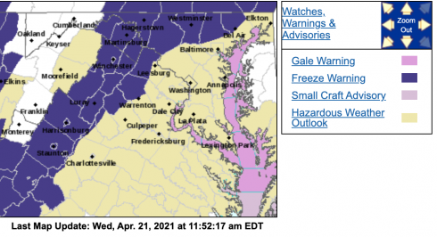
Via NWS : Many counties across the area are under a Freeze Warning late Wednesday night into Thursday morning. For the latest updates from NWS click the image above.
FREEZE WARNING (expanded to include some lowlands east of BRP) URGENT - WEATHER MESSAGE National Weather Service Baltimore MD/Washington DC 906 PM EDT Wed Apr 21 2021 Nelson-Albemarle-Greene-Madison-Culpeper- Including the cities of Lovingston, Charlottesville, Stanardsville, Madison, and Culpeper 906 PM EDT Wed Apr 21 2021 ...FREEZE WARNING IN EFFECT UNTIL 9 AM EDT THURSDAY... ...FREEZE WATCH IN EFFECT FROM LATE THURSDAY NIGHT THROUGH FRIDAY MORNING... * WHAT...For the Freeze Warning, sub-freezing temperatures as low as 32 expected. For the Freeze Watch, sub-freezing temperatures as low as 32 possible. * WHERE...Nelson, Albemarle, Greene, Madison and Culpeper Counties. * WHEN...For the Freeze Warning, until 9 AM EDT Thursday. For the Freeze Watch, from late Thursday night through Friday morning. * IMPACTS...Frost and freeze conditions will kill crops, other sensitive vegetation and possibly damage unprotected outdoor plumbing. PRECAUTIONARY/PREPAREDNESS ACTIONS... Take steps now to protect tender plants from the cold. To prevent freezing and possible bursting of outdoor water pipes they should be wrapped, drained, or allowed to drip slowly. Those that have in-ground sprinkler systems should drain them and cover above- ground pipes to protect them from freezing.
FREEZE WARNING URGENT - WEATHER MESSAGE National Weather Service Baltimore MD/Washington DC 408 AM EDT Wed Apr 21 2021 Augusta-Rockingham-Shenandoah-Frederick VA-Page-Warren-Clarke- Northern Virginia Blue Ridge-Central Virginia Blue Ridge-Morgan- Berkeley-Jefferson- Including the cities of Staunton, Waynesboro, Stuarts Draft, Harrisonburg, Strasburg, Woodstock, Mount Jackson, New Market, Winchester, Luray, Shenandoah, Stanley, Front Royal, Berryville, Big Meadows, Wintergreen, Paw Paw, Martinsburg, Charles Town, and Shepherdstown 408 AM EDT Wed Apr 21 2021 ...FREEZE WARNING IN EFFECT FROM MIDNIGHT TONIGHT TO 9 AM EDT THURSDAY... * WHAT...Sub-freezing temperatures ranging from 25 to 30 along the ridges above 1500 feet to around 30 to 32 degrees in the valleys. * WHERE...The Shenandoah Valley, Blue Ridge Mountains, and eastern Panhandle of West Virginia. * WHEN...From midnight tonight to 9 AM EDT Thursday. * IMPACTS...Frost and freeze conditions will kill crops, other sensitive vegetation and possibly damage unprotected outdoor plumbing. PRECAUTIONARY/PREPAREDNESS ACTIONS... Take steps now to protect tender plants from the cold. To prevent freezing and possible bursting of outdoor water pipes they should be wrapped, drained, or allowed to drip slowly. Those that have in-ground sprinkler systems should drain them and cover above- ground pipes to protect them from freezing.
URGENT - WEATHER MESSAGE National Weather Service Blacksburg VA 339 AM EDT Wed Apr 21 2021 Ashe-Alleghany NC-Watauga-Tazewell-Smyth-Bland-Giles-Wythe- Pulaski-Montgomery-Grayson-Carroll-Floyd-Craig-Alleghany VA-Bath- Roanoke-Botetourt-Rockbridge-Mercer-Summers-Monroe- Eastern Greenbrier-Western Greenbrier- Including the cities of West Jefferson, Sparta, Boone, Tazewell, Marion, Bland, Pearisburg, Wytheville, Radford, Pulaski, Blacksburg, Independence, Whitetop, Troutdale, Volney, Galax, Floyd, New Castle, Clifton Forge, Covington, Hot Springs, Roanoke, Salem, Fincastle, Lexington, Buena Vista, Bluefield, Flat Top, Hinton, Hix, Union, Lewisburg, White Sulphur Springs, Alderson, Quinwood, Duo, and Rainelle 339 AM EDT Wed Apr 21 2021 ...FREEZE WARNING IN EFFECT FROM MIDNIGHT TONIGHT TO 9 AM EDT THURSDAY... * WHAT...Sub-freezing temperatures as low as 26 expected. * WHERE...The mountains of Virginia and North Carolina, as well as southeast West Virginia and the Roanoke Valley. * WHEN...From midnight tonight to 9 AM EDT Thursday. * IMPACTS...Frost and freeze conditions will kill crops, other sensitive vegetation. PRECAUTIONARY/PREPAREDNESS ACTIONS... Take steps now to protect tender plants from the cold. && $$
URGENT - WEATHER MESSAGE National Weather Service Blacksburg VA 339 AM EDT Wed Apr 21 2021 NCZ003-004-019-020-VAZ032>035-043-211545- /O.NEW.KRNK.FZ.W.0001.210422T0400Z-210422T1300Z/ Surry-Stokes-Wilkes-Yadkin-Patrick-Franklin-Bedford-Amherst-Henry- Including the cities of Dobson, Danbury, Wilkesboro, Yadkinville, Stuart, Rocky Mount, Bedford, Amherst, and Martinsville 339 AM EDT Wed Apr 21 2021 ...FREEZE WARNING IN EFFECT FROM MIDNIGHT TONIGHT TO 9 AM EDT THURSDAY... * WHAT...Sub-freezing temperatures as low as 31 expected. * WHERE...In Virginia, Patrick, Franklin, Bedford, Amherst and Henry Counties. In North Carolina, Surry, Stokes, Wilkes and Yadkin Counties. * WHEN...From midnight tonight to 9 AM EDT Thursday. * IMPACTS...Frost and freeze conditions will kill crops, other sensitive vegetation. PRECAUTIONARY/PREPAREDNESS ACTIONS... Take steps now to protect tender plants from the cold.
Via NWS : Some parts of the area will be under freeze watch / warning bulletins for late Wednesday night into Thursday morning. For the absolute latest updates, click on the image above.
FREEZE WATCH
URGENT - WEATHER MESSAGE
National Weather Service Baltimore MD/Washington DC
245 PM EDT Tue Apr 20 2021

Augusta-Rockingham-Shenandoah-Frederick VA-Page-Warren-Clarke-
Northern Virginia Blue Ridge-Central Virginia Blue Ridge-Morgan-
Berkeley-Jefferson-
Including the cities of Staunton, Waynesboro, Stuarts Draft,
Harrisonburg, Strasburg, Woodstock, Mount Jackson, New Market,
Winchester, Luray, Shenandoah, Stanley, Front Royal, Berryville,
Big Meadows, Wintergreen, Paw Paw, Martinsburg, Charles Town,
and Shepherdstown
245 PM EDT Tue Apr 20 2021

...FREEZE WATCH IN EFFECT FROM LATE WEDNESDAY NIGHT THROUGH
THURSDAY MORNING...

* WHAT...Sub-freezing temperatures in the upper 20s and lower 30s
  possible.

* WHERE...Portions of the Shenandoah Valley and Blue Ridge
  Mountains.

* WHEN...From late Wednesday night through Thursday morning.

* IMPACTS...Frost and freeze conditions could kill crops and
  other sensitive vegetation and possibly damage unprotected
  outdoor plumbing.

PRECAUTIONARY/PREPAREDNESS ACTIONS...

Take steps now to protect tender plants from the cold. To prevent
freezing and possible bursting of outdoor water pipes they should
be wrapped, drained, or allowed to drip slowly. Those that have
in-ground sprinkler systems should drain them and cover above-
ground pipes to protect them from freezing.
URGENT - WEATHER MESSAGE
National Weather Service Blacksburg VA
236 PM EDT Tue Apr 20 2021

Roanoke-Botetourt-Rockbridge-
Including the cities of Roanoke, Salem, Fincastle, Lexington,
and Buena Vista
236 PM EDT Tue Apr 20 2021

...FREEZE WATCH IN EFFECT FROM LATE WEDNESDAY NIGHT THROUGH
THURSDAY MORNING...

* WHAT...Windy with sub-freezing temperatures as low as 28
  possible.

* WHERE...Roanoke, Botetourt and Rockbridge Counties.

* WHEN...From late Wednesday night through Thursday morning.

* IMPACTS...Freezing conditions could damage or kill crops, and
  other sensitive vegetation.

* ADDITIONAL DETAILS...Sub-freezing conditions are possible
  again Thursday night.

PRECAUTIONARY/PREPAREDNESS ACTIONS...

Take steps now to protect tender plants from the cold. To prevent
freezing and possible bursting of outdoor water pipes they should
be wrapped, drained, or allowed to drip slowly. Those that have
in-ground sprinkler systems should drain them and cover above-
ground pipes to protect them from freezing.
Photo courtesy of Maddie Crandall : Late Friday morning another big rig has blocked the area near Reeds Gap and the intersection of the Blue Ridge Parkway near Wintergreen. April 16, 2021
Reeds Gap
Near Wintergreen Augusta/Nelson County Line
Once again another 18 wheeler has gotten stuck near the Reeds Gap intersection at the Blue Ridge Parkway. We go work just before noon Friday. We’re told there’s a small area where a car can get by, no official word on traffic or delays so far.
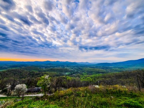
Thanks to Luis Ramos Obando for this beautiful photo that shows the spring green taking hold in the Blue Ridge Mountains of Central Virginia. Wednesday – April 14, 2021
Afton
Nelson County, Virginia
You know warmer days are ahead when you start seeing the green colors down below in the valley heading up the side of the mountains. Our buddy Luis Ramos Obando took this fantastic photo and sent it to us earlier today. We think this is from the Route 250 Afton Mountain overlook – looking down into the Rockfish Valley of Nelson. (still trying to confirm the exact place it was shot from)
Virginia State Police Trooper J.M. Cappo is investigating a plane crash that occurred at 7:08 p.m. on April 12 in Augusta County.
A Piper PA-28-140 was conducting touch-and-go landings at the Shenandoah Valley Regional Airport in Weyers Cave. As the small aircraft was attempting to land, the pilot’s controls became unresponsive which caused the plane to drift left. The plane caught a limb and then struck several trees just outside the airport property.
The 17-year-old male pilot from Romney, W.Va. was transported to UVA Medical Center for treatment of serious, but non-life threatening, injuries. The juvenile male passenger was transported to Rockingham Memorial Hospital for treatment of non-life threatening injuries.
The FAA and NTSB were both notified. The crash remains under investigation.
Corinne N. Geller
Public Relations Director
Virginia State Police
Updated post 4.13.21
Early Tuesday morning we told you about a Monday night plane crash near the airport in Weyers Cave. (See original VSP release down below)
The National Transportation Safety Board is now investigating the small plane crash that happened near SHD Monday night. A complete investigation could take 12-24 months according to NTSB. The aircraft will be removed sometime today or tomorrow @WHSVnewspic.twitter.com/shJsFDRz8E