|
|

|
|

Wintergreen Resort / Lovingston
Nelson County, Virginia
For longer than we have been in business (since 2005) Wintergreen Resort has been having their annual 4th of July fireworks display. They generally do it on New Years as well.
Saturday night the sky was full of brilliant colors over the mountain and in the valley below.
Our longtime BRL Mountain Photographer Paul Purpura was out there to grab a few shots for us. Paul has been with us since the beginning and anything on the mountain he always gets for us.
Here’s just. few pic from his gallery (below) from Saturday night’s fireworks.


To the east in Lovingston the annual fireworks display was held there as well. Though Lovingsotn Volunteer FD was also busy running calls due to all of the storms that hit the area that evening.
Hope everyone had a great 4th!

Nelson County, Virginia
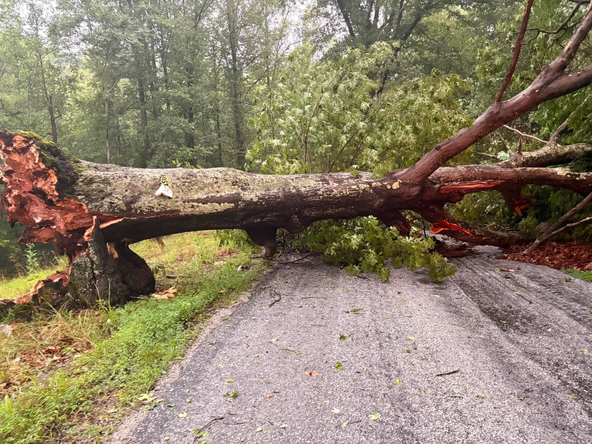
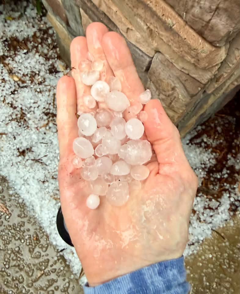
Mother Nature had some fireworks of her own Saturday afternoon as a round of severe thunderstorms moved through. The hardest hit areas in Nelson appeared to be generally from Brents Gap northward toward Nellysford and points east. Trees were down on Adail Road and some along Route 151 as well.
Lots more storm reports and photos can be found in the discussion from our BRL Facebook Post below as it was happening on the 4th of July. (you can also click on the radar image below to go to that post)
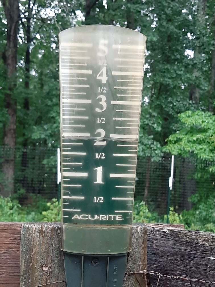
While areas like Arrington picked up a very respectable 2″ of rain, places like Roseland saw less that 1/10th of an inch of rainfall.
There’s another chance for some strong to severe storms this afternoon. But, temperatures will be slightly cooler than the last three to four days.
Tommy

Nelson County, Virginia
Yesterday on June 29th I posted an infrared satellite image of the June 29, 2012 derecho on our Facebook page. That storm hit much of the Ohio Valley and Mid Atlantic, including Nelson, 14 years ago this month.
Here’s the first post I put up on our website shortly after it hit.
In yesterday’s Facebook post I asked what people remembered about that night. We got tons, dozens and dozens, of responses and how everyone remembered when it hit, the miserably hot weather and the days that followed during recovery.
Click on our Facebook image below where it says (see more) to go and read some of the comments. You don’t have to be on Facebook to be able to see it. It’s really interesting, and thank you to everyone that chimed in and told us your stories!

From VDOT Richmond:
America’s 250th anniversary is expected to bring Virginians out to enjoy fireworks, cookouts and events across the commonwealth. As people prepare to travel for the holiday, the Virginia Department of Transportation (VDOT) is working to keep traffic moving smoothly and reminding everyone that the safest way to join celebrations is by driving responsibly.
As part of VDOT’s annual July Fourth holiday travel accommodations, many highway work zones will be suspended and temporary lane closures on interstates and other major roads will be lifted from noon on Thursday, July 2 until noon on Monday, July 6.
While lane closures will be lifted in most locations, motorists may encounter semi-permanent work zones that remain in place during this time. Check VDOT’s Travel Advisories for the latest travel alerts in your area and around the state.
Special events are taking place across the commonwealth all year, with major celebrations for America’s birthdayhappening July Fourth weekend. Signature events, according to Virginia’s American Revolution 250 Commission, include Williamsburg, the capital city of revolutionary Virginia, where a daylong celebration on July 4 concludes with a drone and fireworks extravaganza. Additionally, Founding Father Thomas Jefferson’s Virginia estate, Monticello, will have festivities, including a naturalization ceremony. Separately, Washington, D.C., is also hosting July Fourth celebrations.
To help people navigate the influx of travelers in Virginia, VDOT offers several resources to help plan their trip ahead of time.
PLAN AHEAD WITH 511 VIRGINIA AND VIEW THE TRAVEL TRENDS MAP
VDOT’s free mobile 511 app offers information about traffic, incidents, congestion and construction as well as access to traffic cameras, weather, electric vehicle charging stations and more. By calling 511 from any phone in Virginia, use 511’s “speak ahead” option for hands-free and eyes-free audible traffic alerts for incidents and construction along your route. Traffic information is also available at 511.vdot.virginia.gov.
The 511 Virginia website also includes a travel trends map for the Fourth of July holiday timeframe, showing peak congestion periods anticipated on Virginia interstates during the upcoming holiday travel. While it cannot precisely predict when congestion will occur this year, it can help motorists avoid travel when traffic has historically moved the slowest. Using the menu at the top of 511.vdot.virginia.gov, click “Holiday Travel” to select the map. Travelers are advised to plan for extra time to get to and from the many events across the commonwealth to mark America’s 250th anniversary.
NORTHERN VIRGINIA EXPRESS LANES SCHEDULE AND OTHER INFORMATION
Find directional schedules for the reversible I-95 and I-395 Express Lanes, and information for the I-495 Express Lanes at expresslanes.com.
HAMPTON ROADS TUNNELS AND OTHER INFORMATION
Travel to Virginia Beach — Peninsula traffic to Virginia Beach is encouraged to use the I-664 Monitor-Merrimac Memorial Bridge-Tunnel (MMMBT) as an alternative to the Hampton Roads Bridge-Tunnel (HRBT) during construction. If traveling to Virginia Beach, take I-664 south to the MMMBT. Then take the Portsmouth/Norfolk exit (exit 15A) to I-264 east to Virginia Beach.
Travel to Outer Banks — Traffic to the North Carolina Outer Banks should use I-664 and the MMMBT as an alternative to the HRBT to save time during construction. From I-664 south, take I-64 west (exit 15, Chesapeake/Virginia Beach) to exit 291B [Chesapeake Expressway (Route 168)/Great Bridge/Nags Head]. Continue south on Route 168 to the Outer Banks.
STAY SAFE
Here are some additional tips for safely navigating the roadways during the holiday travel period:
For questions or to report hazardous road conditions, contact VDOT’s 24-hour Customer Service Center by visiting my.vdot.virginia.gov or calling 800-FOR-ROAD (367-7623).

Arrington
Nelson Co, VA
4:45 PM – 6.17.26
Crews responded to the Nelson Water plant this afternoon on Tye Brook Highway for a chlorine gas leak. The scene has now been cleared and the leak stopped. Wintergreen Fire and Rescue Chief Curtis Sheets said his agency assisted on the scene with other agencies as well. He told us the following Wednesday afternoon.
“A cylinder of Chorine gas developed a leak. NCSA staff used on-site leak kit and protocols to immediately mitigate, however ultimately could not stop the leak. The facility was evacuated due to health risks associated with Chlorine. Piney River FD has command and are being assisted by Wintergreen and Lovingston FD. Nelson EMS is providing medical standby. Virginia Department of Emergency Management provided consultation.
These leaks are uncommon however not unheard of. NCSA acted appropriately by notifying 911 immediately.“
")
Greenfield
Nelson County, Virginia
For as long as people can remember the huge oak tree at the intersection of Greenfield Road and Route 151 has been standing. (That’s diagonally across the highway from Ashley’s Market) Friday night half of that tree came down during severe storms that hit the northern part of the county.
Above the moment the tree split in half and fell. Letty Hernandez caught the exact moment while she was filming the passing storm.
Above, Yvette shot video the next morning after the storm. Press play to see the full clip.
Sad to see such a majestic tree and landmark take such a beating.

Lovingston
Nelson County, Virginia
An abrupt cancellation of a highly publicized auction that was to take place in June made a bizarre turn when it was discovered that the County of Nelson had entered into an agreement to buy about 683 acres of raw land just south of Lovingston. The property of on the eastern side of U.S. Route 29.
The share to our BRLM Facebook page made for a lot of comments.
Click see more above to read more from our Facebook page
Here is the verbatim press release from the Nelson County Administrator’s office:
“FOR IMMEDIATE RELEASE
LOVINGSTON, VA – Nelson County has successfully acquired approximately 683 acres
along the Route 29 corridor south of Lovingston through a pre-auction purchase
agreement at an all-in cost of $8,925,000. The acquisition represents a strategic
investment in an area long identified by County planning efforts as a key location for
future economic development because of its transportation access and proximity to
existing infrastructure.
County Administrator, Candy McGarry said ” The financial stewardship of the Board of
Supervisors over the years enabled the County to react quickly to this opportunity.
Purchase of the property fits within the already established debt capacity strategy,
without additional General Fund revenues; therefore, there is no increased burden on
the taxpayer.”
County officials recognize the public interest surrounding the purchase and are
committed to transparency throughout the process. The acquisition allows the County to
evaluate future opportunities for this strategically located property, rather than seeing it
pass into private ownership without public input.
County officials emphasized several important points:
* The acquisition does not approve or commit the County to any specific development
project.
* No rezoning actions are being proposed as part of this purchase.
* Any future use of the property would require public discussion, community input, and
appropriate governmental approvals.
* County ownership provides greater local control over future outcomes that would not
exist under private ownership.
* The property can be evaluated for a variety of potential public purposes, including
economic development, recreation, infrastructure, or a combination of uses.
* Purchase of the property fits within the already established debt capacity strategy,
without additional General Fund revenues.
The Board believes responsible economic development remains essential to
maintaining quality public services, supporting schools, strengthening public safety, and
reducing pressure on residential property taxpayers. At the same time, County leaders
remain committed to preserving the character, natural beauty, and agricultural heritage
that make Nelson County unique.
Over the coming months, the County will conduct additional analysis regarding the
property’s opportunities, constraints, infrastructure needs, environmental considerations,
and potential public benefits. Citizens will have multiple opportunities to participate in
those discussions.
“This is not the end of a process, it is the beginning of one,” said Dr. Jessica Ligon,
Board Chair. “The purchase simply ensures that Nelson County residents will have a
seat at the table in determining the future of this property.” Additional information
regarding the acquisition and future public engagement opportunities will be made
available through County meetings and official communication channels.
About Nelson County
Nelson County is committed to fostering economic vitality while preserving the rural
character, natural resources, and quality of life that define our community. The County
works to balance responsible growth, environmental stewardship, and fiscal
responsibility for current and future generations.”

Afton
Nelson County, Virginia
RVCC Prepares for “New Rock Era”
The Board of Directors of Rockfish Valley Community Center in Afton has announced the successful conclusion of its leadership succession planning process, following the announcement last year that Chief Executive Officer Stu Mills would be retiring this August.
After vetting and interviewing a number of candidates for the position, the Board’s Search Committee has recommended, and the full Board has unanimously agreed, to elevate current Chief Operating Officer Sara Taylor to the CEO position. Taylor will assume the role on August 15th.
Both Mills and Taylor have been with RVCC in their respective positions since 2012, and have overseen its growth in membership, program expansion, infrastructure improvements and financial security over the past 14 years.
“Although the Board is sad to say goodbye to Stu Mills after a very successful tenure as CEO,” said Chery Klueh, RVCC Board Chair, “we could not be happier that Sara Taylor will succeed him, guaranteeing a smooth transition.”

Nellysford
Nelson County, Virginia
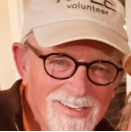
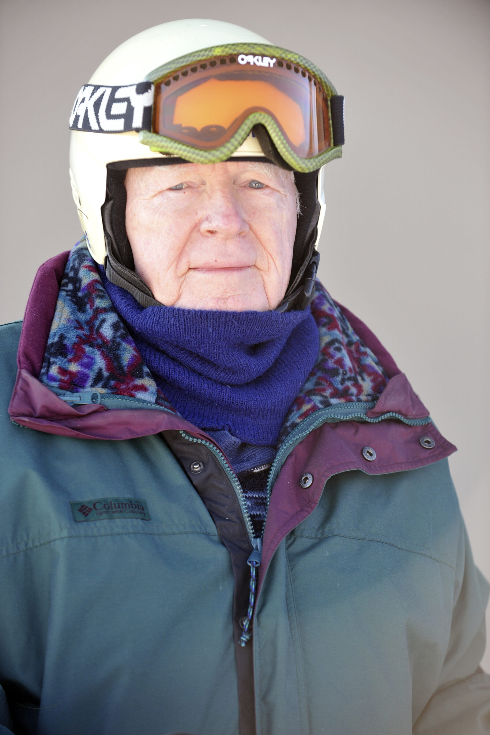
The memory is so strong it feels like yesterday. Yvette and I were walking into the Rockfish Valley Community Center just north of Nellysford on a winter morning. The smell of frying bacon and pancakes cooking on the griddle filled the air. Dozens of people were lined up getting stacks of pancakes, bacon and eggs then headed for the makeshift dining room in an old classroom of the school that’s seen a lot of history. That must have been around late 2004 or early 2005.
Once we got seated and started tearing into our breakfast I noticed this man wearing an AOPA hat nearby. (Aircraft Owners & Pilots Association) That wouldn’t mean a thing to most folks. But, if you’re a private pilot, like me, it’s means you have found your tribe. I asked the man, “Do you just wear the hat or are you really a pilot?” A short and concise reply, “I am.” From there the conversation flowed and didn’t stop for over two decades.
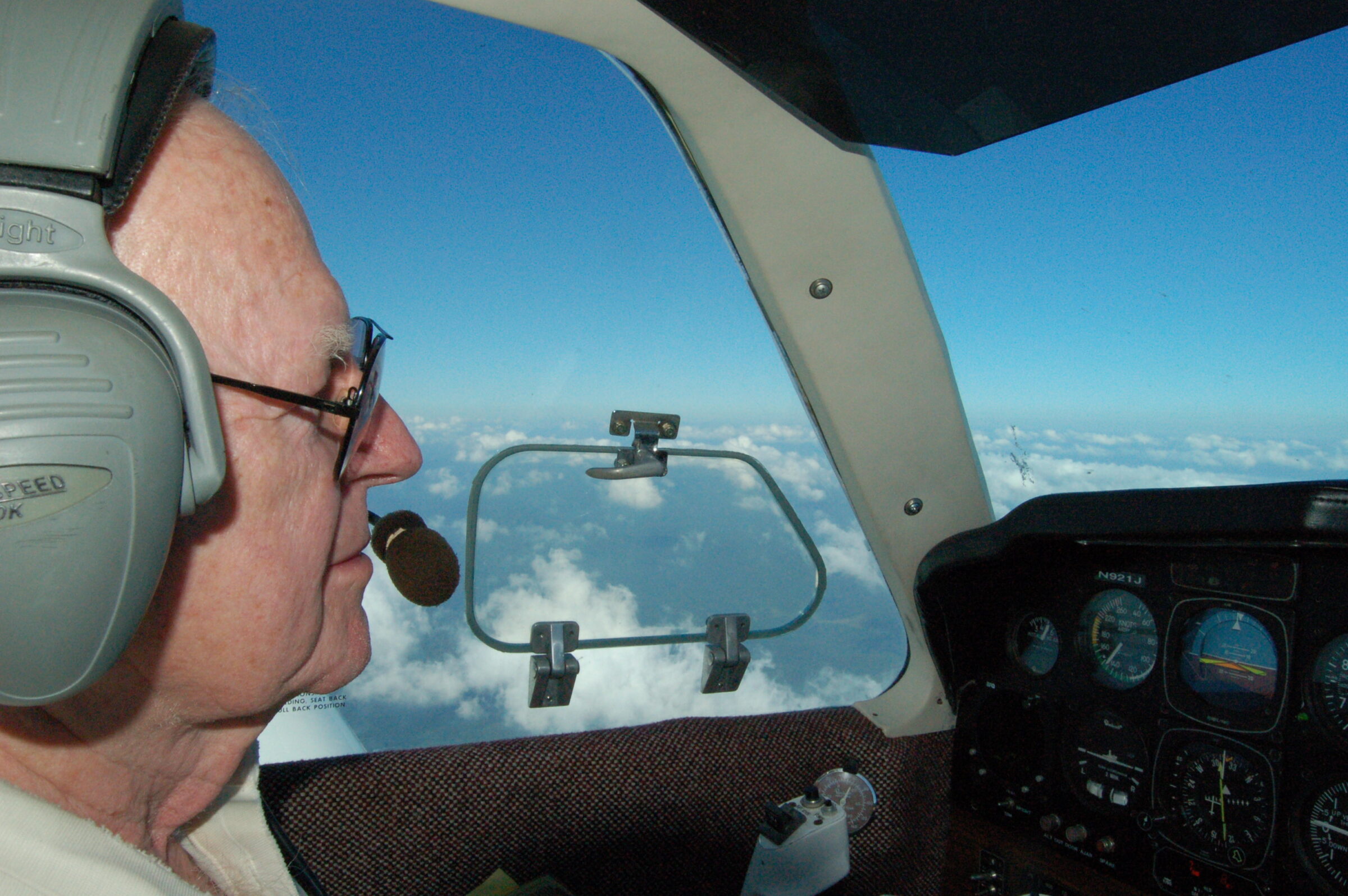
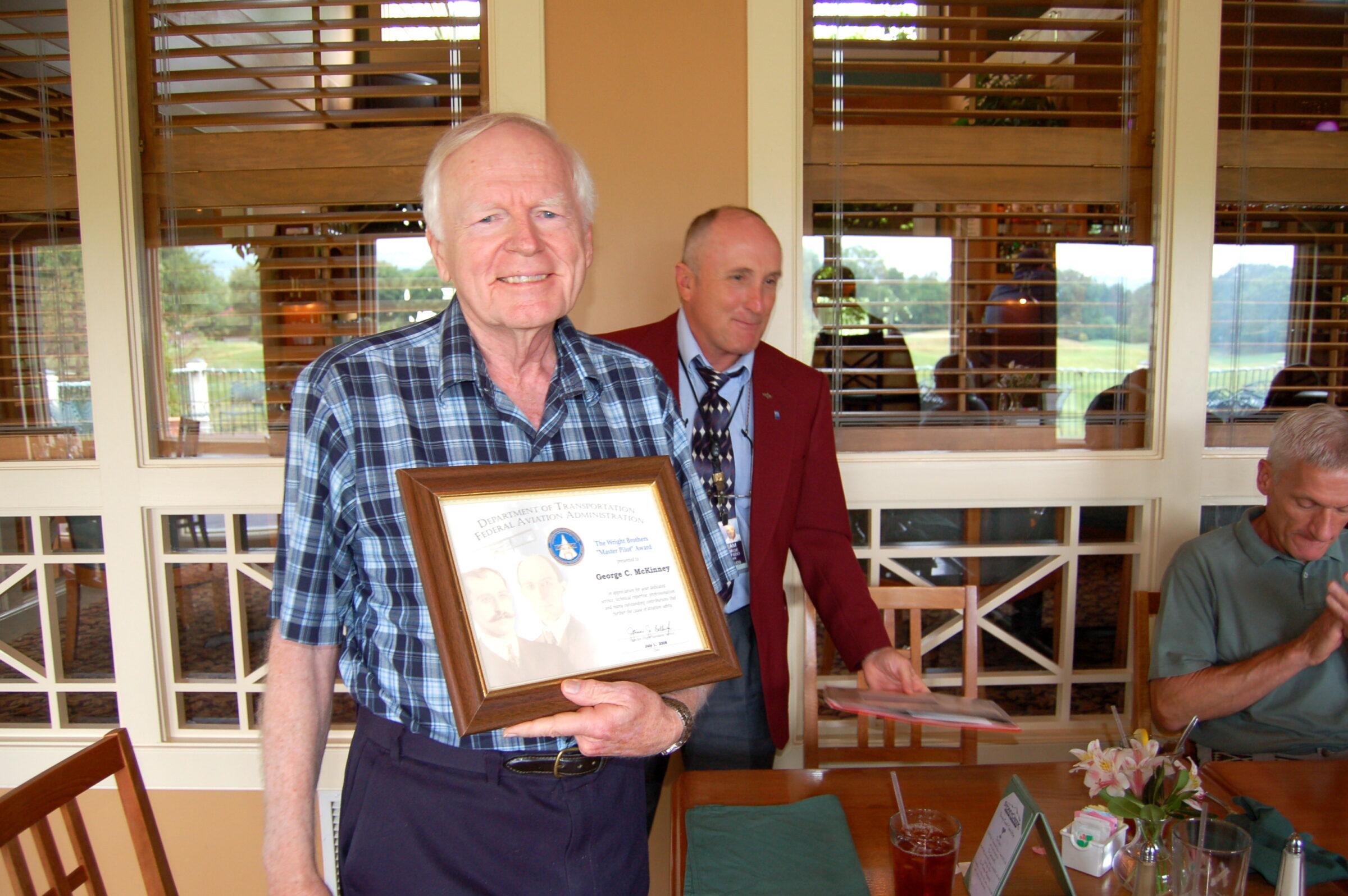
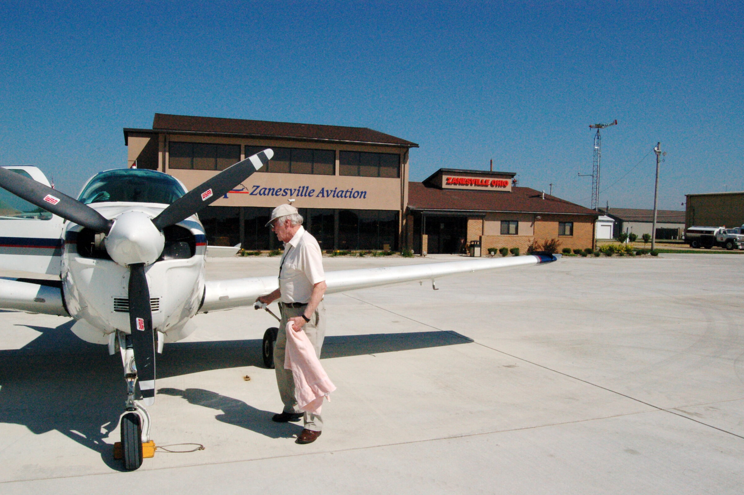
George and I took several more flights together and like most long time pilots we had thousands of stories to tell each other. I was a novice compared to George, even though I was licensed for airplanes back in 1980 and helicopters two years later in 1982. George’s history goes way back. By 2008 he already had over a half century of pilot experience.
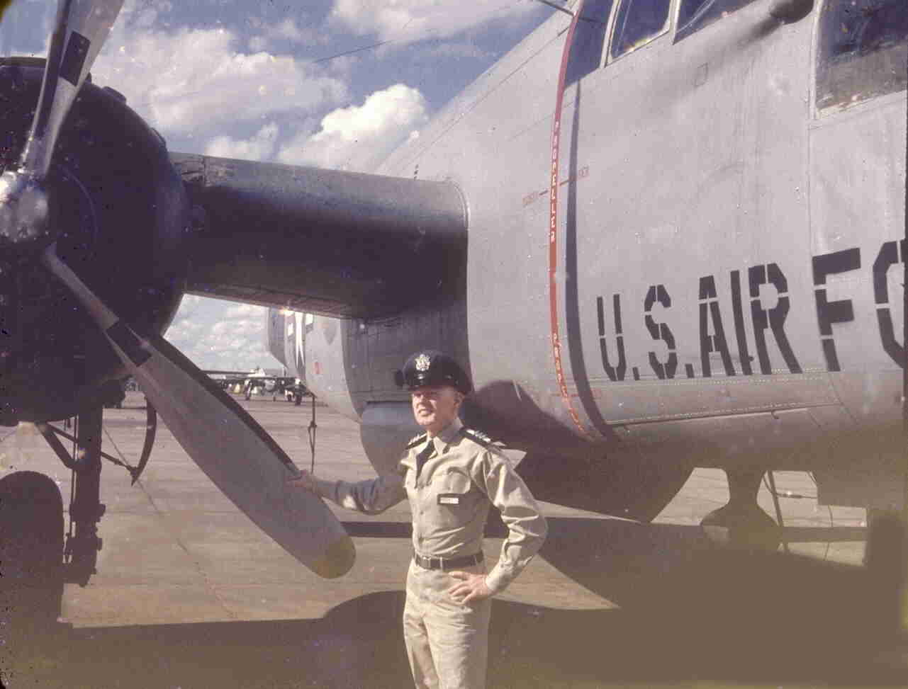
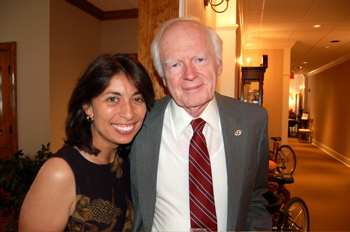
George’s flying experience was so highly regarded he received the prestigious Wright Brothers Master Pilot Award from the FAA back in 2008 during a ceremony held at the former Stoney Creek Bar & Grill.
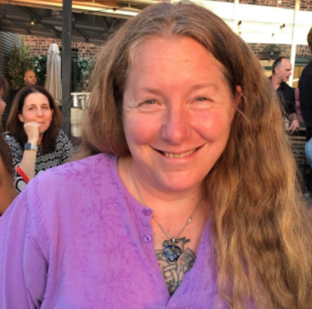
Outside of flying I got to know George and his wife Mickey on a personal level too. I vividly remember a lovely memorial dinner they held for a fellow Wintergreen(er) Brian O’Rourke when he passed away many years ago. George sang Danny Boy at the dinner. He had an impressive singing voice like no other!
One of my fondest memories of George is when he’d call or showed up at the house back when we were living in Greenfield. Usually Mickey was out of state visiting kids or grandkids. George always brought over steaks and we’d have a nice bottle of red wine. We’d grill on the deck out back and talk for hours and hours.
I always assumed George would be as active as he was when I first got to know him. He reminded me so much of another pilot mentor of mine, Charmiane Freeman, back during my days of flying in the Mid-South. She flew well into her 80s and drove until about age 90 before passing a couple of years later. She also helped get George approved for the Wright Brothers Award, though the two had never met. There’s a special kinship between pilots even if they don’t know each other.
As age has a way of catching up, it did with George too. Body parts wear out, and need fixing. George had knee replacement surgery sometime in his 80s, it didn’t go well ultimately and there was a period of time he wasn’t expected to make it. George told me everyone was prepared for him to pass then. But, it wasn’t his time just yet.
After severe infections, hospitalizations, a replacement for the new replacement, George emerged.
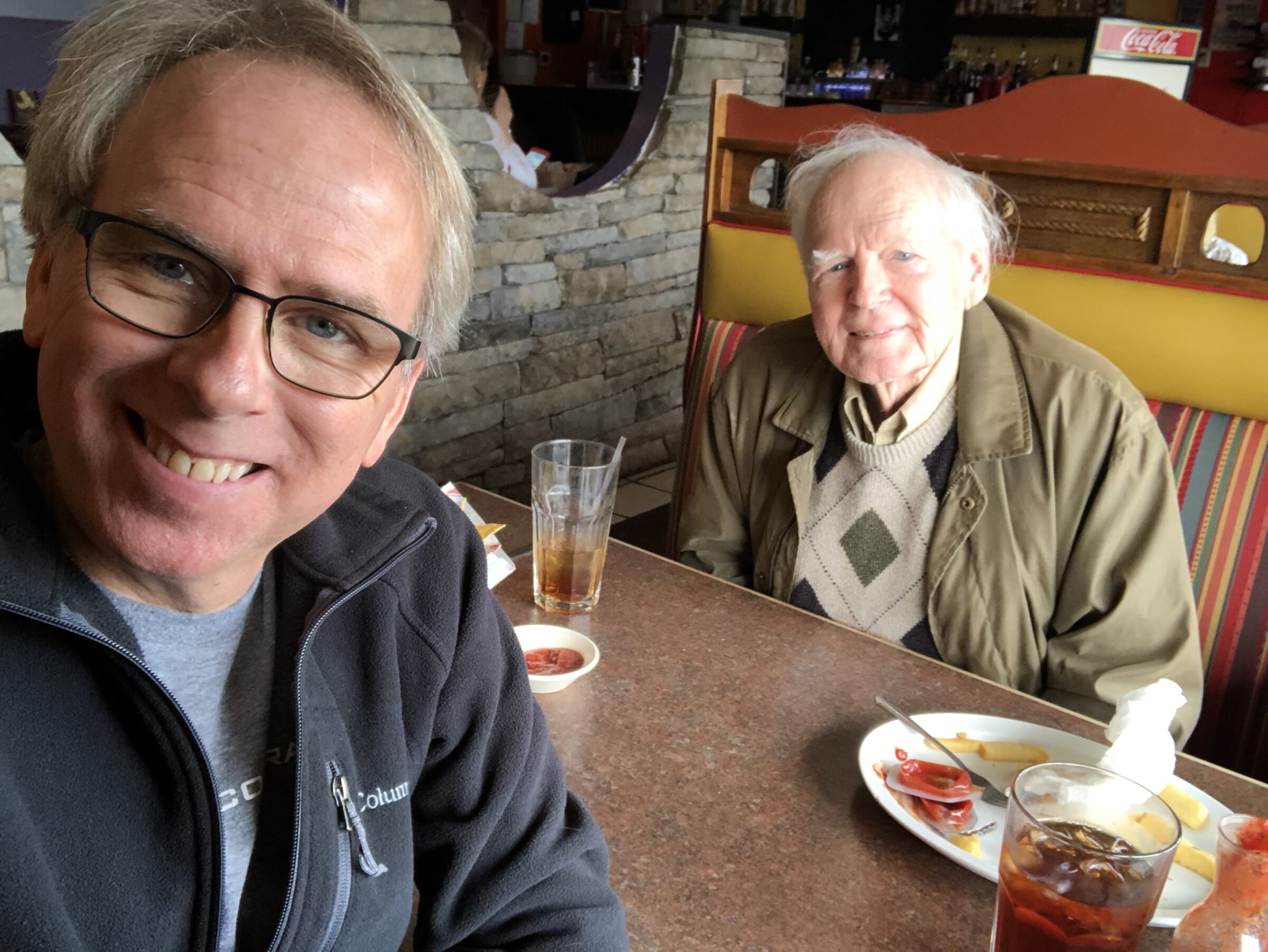
I remember looking out the window one day while having lunch at the old Margaritas in Nellysford and there was George getting out of his car to head into the IGA. I jumped up and ran out, not knowing of his miraculous recovery. I remember saying, “George you’re not supposed to be here.” He said, “Indeed I am not, but here I am.” We both laughed and set a lunch date a few days later and caught up.
Not only was George active in skiing and flying and so many other things, he was also a big supporter of what was then called Wintergreen Performing Arts. Always helping with their annual festival each summer. He’d volunteered with them for decades.
Not long after I’d met George for that wonderful catchup lunch back in 2018, the unthinkable happened. He had another big setback, a stroke. Though he lost his ability to drive, fly, ski and such, he continued pushing on with a lot of limitations, yet enjoying life as he could from his home in Stoney Creek.
I lost touch with George, mostly, during those years. I’d get updates from Mickey when I’d run into her or from other relatives. Yvette had seen him a time or two but life had certainly changed as it does for all of us.
Then several days ago I got a message from our mutual friend John Taylor up on Devils Knob. John and George worked together a lot on the Wintergreen Summer Music Festival over the years. John told me, “George is gone.”
It was strange knowing George wasn’t with us anymore, but also nice knowing he’s soaring across those crystal blue skies he so loved to fly in for over half a century. George made to 95 years old, not a bad run at all.
There will be a celebration of life held for George later this summer on July 26th at the McKinney home in Nellysford. Here’s George’s formal obituary that’s got an even more detailed history of spectacular life!
Seeing a Bonanza flying across the sky these days will sure have a different meaning now George, fly high my friend.
