Home Blog Page 735

Albemarle : Severe Thunderstorm Warning until 6:45 PM EDT

0

REFRESH Nelson County Life Magazine HERE for the latest updates:

BULLETIN – EAS ACTIVATION REQUESTED
SEVERE THUNDERSTORM WARNING
NATIONAL WEATHER SERVICE BALTIMORE MD/WASHINGTON DC
539 PM EDT THU AUG 16 2007

THE NATIONAL WEATHER SERVICE IN STERLING VIRGINIA HAS ISSUED A

* SEVERE THUNDERSTORM WARNING FOR…
ALBEMARLE COUNTY IN CENTRAL VIRGINIA

* UNTIL 645 PM EDT

* AT 534 PM EDT…NATIONAL WEATHER SERVICE DOPPLER RADAR INDICATED A
SEVERE THUNDERSTORM. THIS STORM WAS LOCATED NEAR ADVANCE MILLS…
AND MOVING SOUTHEAST AT 25 MPH.

* LOCATIONS IMPACTED INCLUDE…
STONY POINT…
COBHAM…

HAIL TO THE SIZE OF PENNIES AND WIND GUSTS TO 60 MPH CAN BE EXPECTED
IN THE WARNED AREA. STAY INDOORS AND AWAY FROM WINDOWS UNTIL THE
STORM HAS PASSED.

Amherst : Severe Thunderstorm Warning until 6:00 PM EDT

0

REFRESH Nelson County Life Magazine HERE for the latest updates:

View local radar by clicking here.

BULLETIN – IMMEDIATE BROADCAST REQUESTED
SEVERE THUNDERSTORM WARNING
NATIONAL WEATHER SERVICE BLACKSBURG VA
507 PM EDT THU AUG 16 2007

THE NATIONAL WEATHER SERVICE IN BLACKSBURG HAS ISSUED A

* SEVERE THUNDERSTORM WARNING FOR…
AMHERST COUNTY IN CENTRAL VIRGINIA

* UNTIL 600 PM EDT

* AT 504 PM EDT…NATIONAL WEATHER SERVICE DOPPLER RADAR INDICATED A
SEVERE THUNDERSTORM CAPABLE OF PRODUCING NICKEL SIZE HAIL…AND
DAMAGING WINDS IN EXCESS OF 60 MPH. THIS STORM WAS LOCATED NEAR
NAOLA…OR ABOUT NEAR BIG ISLAND…AND MOVING SOUTHEAST AT 20 MPH.

* LOCATIONS IMPACTED INCLUDE…
NAOLA…
FORKS OF BUFFALO…
ELON…
FALCONERVILLE…

IF YOU ARE CAUGHT OUTSIDE…SEEK SHELTER FROM THE WEATHER IN A STRONG
BUILDING. DAMAGING WIND…LARGE HAIL…VERY HEAVY RAIN…AND DEADLY
LIGHTNING ARE ALL POSSIBLE IN SEVERE THUNDERSTORMS. STAY INSIDE AWAY
FROM WINDOWS UNTIL THE STORM HAS PASSED.

PLEASE SEND YOUR REPORTS OF PENNY OR LARGER SIZED HAIL…AS WELL AS
WIND DAMAGE…INCLUDING TREES OR LARGE LIMBS DOWNED BY CALLING THE
NATIONAL WEATHER SERVICE TOLL FREE AT…1…8 6 6…2 1 5…4 3 2 4.

Nelson & Central VA : Severe Thunderstorm Watch until 11 PM EDT

0

REFRESH Nelson County Life Magazine HERE for the latest updates:

URGENT – IMMEDIATE BROADCAST REQUESTED
SEVERE THUNDERSTORM WATCH NUMBER 606
NWS STORM PREDICTION CENTER NORMAN OK
445 PM EDT THU AUG 16 2007

THE NWS STORM PREDICTION CENTER HAS ISSUED A
SEVERE THUNDERSTORM WATCH FOR PORTIONS OF

SOUTHERN MARYLAND
NORTHERN NORTH CAROLINA
CENTRAL AND EASTERN VIRGINIA
COASTAL WATERS

EFFECTIVE THIS THURSDAY AFTERNOON AND EVENING FROM 445 PM UNTIL
1100 PM EDT.

HAIL TO 1.5 INCHES IN DIAMETER…THUNDERSTORM WIND GUSTS TO 70
MPH…AND DANGEROUS LIGHTNING ARE POSSIBLE IN THESE AREAS.

THE SEVERE THUNDERSTORM WATCH AREA IS APPROXIMATELY ALONG AND 75
STATUTE MILES EAST AND WEST OF A LINE FROM 70 MILES NORTHEAST OF
CHARLOTTESVILLE VIRGINIA TO 40 MILES EAST SOUTHEAST OF DANVILLE
VIRGINIA. FOR A COMPLETE DEPICTION OF THE WATCH SEE THE
ASSOCIATED WATCH OUTLINE UPDATE (WOUS64 KWNS WOU6).

REMEMBER…A SEVERE THUNDERSTORM WATCH MEANS CONDITIONS ARE
FAVORABLE FOR SEVERE THUNDERSTORMS IN AND CLOSE TO THE WATCH
AREA. PERSONS IN THESE AREAS SHOULD BE ON THE LOOKOUT FOR
THREATENING WEATHER CONDITIONS AND LISTEN FOR LATER STATEMENTS
AND POSSIBLE WARNINGS. SEVERE THUNDERSTORMS CAN AND OCCASIONALLY
DO PRODUCE TORNADOES.

Area outline of cities affected:

THE NATIONAL WEATHER SERVICE HAS ISSUED SEVERE THUNDERSTORM WATCH
606 IN EFFECT UNTIL 11 PM EDT THIS EVENING FOR THE FOLLOWING
AREAS

IN MARYLAND THIS WATCH INCLUDES 3 COUNTIES

IN SOUTHERN MARYLAND

CALVERT CHARLES ST. MARYS

IN VIRGINIA THIS WATCH INCLUDES 15 COUNTIES

IN CENTRAL VIRGINIA

ALBEMARLE GREENE KING GEORGE
NELSON ORANGE SPOTSYLVANIA

IN NORTHERN VIRGINIA

CULPEPER FAUQUIER PRINCE WILLIAM
STAFFORD

IN NORTHWEST VIRGINIA

MADISON PAGE RAPPAHANNOCK

IN WESTERN VIRGINIA

AUGUSTA ROCKINGHAM

IN VIRGINIA THIS WATCH INCLUDES 8 INDEPENDENT CITIES

IN CENTRAL VIRGINIA

CHARLOTTESVILLE CITY OF FREDERICKSBURG

IN NORTHERN VIRGINIA

CITY OF ALEXANDRIA CITY OF FAIRFAX CITY OF MANASSAS
CITY OF MANASSAS PARK

IN NORTHWEST VIRGINIA

CITY OF HARRISONBURG

IN WESTERN VIRGINIA

CITY OF WAYNESBORO

Rockbridge : Severe Thunderstorm Warning until 5:30 PM EDT

0

REFRESH Nelson County Life Magazine HERE for the latest updates:

BULLETIN – IMMEDIATE BROADCAST REQUESTED
SEVERE THUNDERSTORM WARNING
NATIONAL WEATHER SERVICE BLACKSBURG VA
419 PM EDT THU AUG 16 2007

THE NATIONAL WEATHER SERVICE IN BLACKSBURG HAS ISSUED A

* SEVERE THUNDERSTORM WARNING FOR…
CITY OF BUENA VISTA IN WEST CENTRAL VIRGINIA
CITY OF LEXINGTON IN WEST CENTRAL VIRGINIA
SOUTHERN ROCKBRIDGE COUNTY IN WEST CENTRAL VIRGINIA

* UNTIL 530 PM EDT

* AT 416 PM EDT…NATIONAL WEATHER SERVICE DOPPLER RADAR INDICATED A
SEVERE THUNDERSTORM CAPABLE OF PRODUCING DAMAGING WINDS IN EXCESS
OF 60 MPH. THIS STORM WAS LOCATED NEAR COLLIERSTOWN…AND MOVING
EAST AT 15 MPH.

* LOCATIONS IMPACTED INCLUDE…
COLLIERSTOWN…
NATURAL BRIDGE…
LEXINGTON CITY…
GLASGOW…
BUENA VISTA CITY…

IF YOU ARE CAUGHT OUTSIDE…SEEK SHELTER FROM THE WEATHER IN A STRONG
BUILDING. DAMAGING WIND…LARGE HAIL…VERY HEAVY RAIN…AND DEADLY
LIGHTNING ARE ALL POSSIBLE IN SEVERE THUNDERSTORMS. STAY INSIDE AWAY
FROM WINDOWS UNTIL THE STORM HAS PASSED.

PLEASE SEND YOUR REPORTS OF PENNY OR LARGER SIZED HAIL…AS WELL AS
WIND DAMAGE…INCLUDING TREES OR LARGE LIMBS DOWNED BY CALLING THE
NATIONAL WEATHER SERVICE TOLL FREE AT…1…8 6 6…2 1 5…4 3 2 4.

Nelson : Special Weather Update from NCL Updated 4:17 PM EDT

0

REFRESH Nelson County Life Magazine HERE for the latest updates:

Updated: 4:17 PM EDT
The area of concern in the northern half of Virginia has stabilized. There is still some concern for severe weather in Central and Southern Virginia over the next few hours, but the threat has diminished somewhat.

Keeping an eye on it.
-T-

The atmosphere over the Central Virginia area is becoming very unstable currently. Over the next few hours severe weather is expected to develop. The Storm Prediction Center is considering a watch for our area as indicated below. There discussion is below the map.

I will be watching situation and update accordingly.
-T-

MESOSCALE DISCUSSION 1771
NWS STORM PREDICTION CENTER NORMAN OK
0155 PM CDT THU AUG 16 2007

AREAS AFFECTED…VA

CONCERNING…SEVERE POTENTIAL…WATCH POSSIBLE

VALID 161855Z – 162130Z

THUNDERSTORMS MAY DEVELOP AND INTENSIFY OVER PARTS OF WRN VA AND
SPREAD EWD. OTHER STORMS MAY ALSO DEVELOP OVER SERN VA. CONVECTIVE
TRENDS ARE BEING MONITORED FOR A POSSIBLE WW WITHIN THE NEXT 1 TO 2
HOURS.

THIS AFTERNOON AN MCV WAS OBSERVED OVER SRN NJ…AND THIS FEATURE
WILL CONTINUE EWD AND OFFSHORE. THE ATMOSPHERE APPEARS TO HAVE
UNDERGONE TEMPORARY LARGE SCALE SUBSIDENCE IN WAKE OF THE MCV AND
THIS MAY BE PARTLY RESPONSIBLE FOR THE LACK OF BOUNDARY LAYER
CUMULUS SO FAR. HOWEVER…LATEST SATELLITE TRENDS SHOW CUMULUS
BEGINNING TO BECOME A LITTLE MORE WIDESPREAD ALONG THE WV-VA BORDER
WITH OTHER CUMULUS INCREASING IN VICINITY OF A WEAK BOUNDARY ACROSS
SERN VA. MOSTLY CLEAR SKIES IN WAKE OF MCV AND DEWPOINTS IN THE
UPPER 60S TO LOW 70S ARE RESULTING IN MODERATE MLCAPE WITH STRONGER
INSTABILITY OVER ERN VA WHERE RICHER LOW LEVEL MOISTURE EXISTS. THE
CAP WILL CONTINUE TO WEAKEN AS THE BOUNDARY LAYER WARMS…AND STORMS
ARE EXPECTED TO DEVELOP OVER HIGHER TERRAIN OF WRN VA AND SPREAD
EWD. BELT OF STRONGER MID LEVEL FLOW OVER THE NRN HALF OF VA IS
RESULTING IN 35 TO 40 KT VERTICAL SHEAR WHICH IS SUFFICIENT FOR
ORGANIZED MULTICELLS AND POSSIBLY SOME SUPERCELL STRUCTURES.
DAMAGING WIND AND LARGE HAIL WILL BE THE MAIN THREATS.

Breaking : Afton Mountain : Serious motor vehicle accident

0

REFRESH Nelson County Life Magazine HERE for the latest updates:

Exit 99 crash
Traffic screen shot courtesy of www.Trafficland.com

Updated 4:45 PM EDT
The accident involved a Waynesboro woman who has been confirmed killed from the accident.
-T-

Updated: 1:00 PM
Scene cleared
-T-

Updated 11:39 AM EDT
NCL has learned the accident mostly likely involves a fatality.
More as we have it later in the day.
-T-

11:05 AM EDT
Authorities are on the scene of a major vehicle crash at the top of Afton Mountain at Exit 99. We know someone was thrown from a vehicle.

Updates shortly.
-T-

Thursday Weather : Wintergreen & Nelson County, Virginia : Hot : Some Severe Storms : Cooler Weekend

0

REFRESH Nelson County Life Magazine HERE for the latest updates:

Weathercast by Tommy Stafford, Nelson County Life Magazine

NEW! AUDIO VERSION OF TODAY’S FORECAST

Photography by Paul Purpura
Nelson County Life Magazine – Copyright 2007
Summer Clouds over Lake Monacan
Lovingston, Virginia

monocan clouds

For the most part Wednesday was a nice but warm day across Central Virginia. Our Paul Purpura caught a nice sumer cloud scene above at Lake Monacan. Hard to believe we’ll be talking ice & snow there in just a few short months!

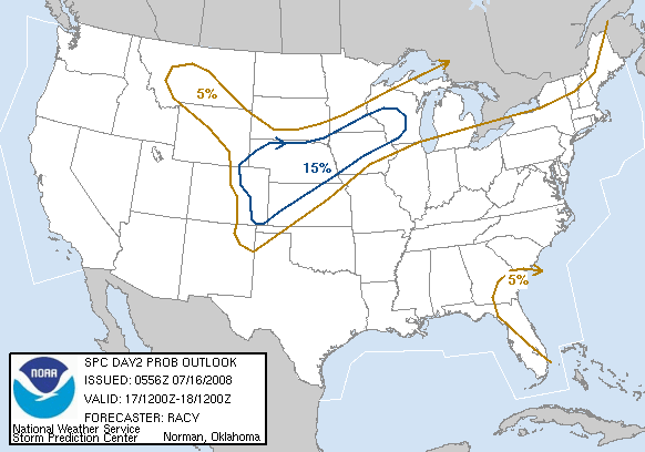
Even though temps made it easily into the mid 90’s Wednesday, the humidity wasn’t very high so it was much more comfortable than last week. Thursday will be a hot day with increasing humidity and temperatures very near 100 degrees. We’ll see increasing chances for thunderstorms by late afternoon and evening. Some storms may become severe. The most likely areas are outlined below:

.DAY ONE…TODAY AND TONIGHT

SCATTERED TO NUMEROUS THUNDERSTORMS CAN BE EXPECTED TODAY AND
TONIGHT. SOME OF THE THUNDERSTORMS MAY BE SEVERE…WITH DAMAGING
WINDS AND LARGE HAIL THE PRIMARY THREATS. GIVEN THE WIND FIELD IN
THE ATMOSPHERE…AN ISOLATED TORNADO MAY ALSO BE POSSIBLE. THE MOST
LIKELY TIME FOR ORGANIZED SEVERE WEATHER WILL BE DURING THE
AFTERNOON AND EVENING.

The biggest severe threat is from straight line thunderstorm winds, but an isolated tornado is possible, especially points north and east of Nelson.

Tropical storm Dean is now Hurricane Dean and continues to peak interest in the Atlantic as it heads toward the gulf. I am not in crisis mode over this storm yet, let’s see how he turns by Sunday. He could go toward Texas / Mexico or get kicked up the Eastern Seaboard. If it still holds together and starts tracking our way by late weekend, then I’ll pay attention more, and so should you, otherwise no worries yet.
Here’s the latest tracking map:

The numbers as of 11:59 PM EDT Monday night

*NCL-Nelson County Life Magazine : Greenfield / Afton
Wed High: 95.5 degrees @ 3:06 PM
0.00″ of rain

*NCL-Wintergreen Nature Foundation : Devil’s Knob
Wed High: 84.6 degrees @ 1:18 PM
0.00″ of rain

*NCL-Wintergreen Winery @ the foot of Wintergreen Mountain in Beech Grove
Wed High: 95.9 degrees @ 2:01 PM
0.00″ of rain

*NCL-Delfosse Vineyard & Winery near Hickory Creek : Faber
Wed High: N/A degrees @ 0:00 PM {STATION OFFLINE}
0.00″ of rain

*NCL-Tiger Fuel – Lovingston
Wed High: 96.1 degrees @ 4:01 PM
0.00″ of rain

*NCL-Mini Tara Vineyards : Arrington
Wed High: 96.1 degrees @ 1:48 PM
0.00″ of rain

On the current surface map, high pressure begins to weaken today as a cold front makes its way toward us.
Current-Sat Surface Map

On the National Forecast Map, the front makes its way into the area this afternoon and tonight. Cooler high pressure moves in for the weekend.
Today’s Forecast Map

Local forecast
*Thursday Partly sunny and hot. Thunderstorms (some severe) by late afternoon into the evening across 40% of the area.
*High temps in Stoney Creek, Rockfish Gap & Schuyler near 100.
*On the mountains above 2000 feet along the BRP, Wintergreen, Three Ridges, Devil’s Knob, and Love, Partly sunny and hot with afternoon & evening thunderstorms.
Highs top out around 88 degrees.
Winds SW 5-10 MPH

*Thursday night Mostly cloudy with showers and thunderstorms (some severe early) across 40% of the area.
*Lows valley around 70 degrees.
*On the mountains overnight low of 69 degrees.
*Winds SW 5-10

Friday Partly sunny with lingering showers or a t-storm early.
*Highs valley near 93
*On the mountains around 80 – Northerly winds.
*Friday night partly cloudy with lows generally in the low 60’s mountain and valley.

By the weekend cooler with highs on around 80 in the valley and near 70 on the mountains. Overnight lows in the 50’s to lower 60’s.

When severe weather or news breaks out, come here. We’ll have all of the latest watches, warnings, and coverage affecting Nelson County, Wintergreen, and nearby counties.

Have a great Thursday!

Know your Nelson
-T-

Datebook : Nellysford : Nelson Farmers’ Market September dates

0

9/1 – Nelson Farmers’ Market Co-op, 8am till noon. Music by Victor Cabas, sponsored by Ashley’s Market. The Farmers’ market is held every Saturday, rain or shine, thru October 13 and is located in Nellysford next to Wintergreen Real Estate. 434-244-2399

9/8 – Nelson Farmers’ Market Co-op, 8 am till noon. Music by Red Drum Ramblers, sponsored by GAIA Homes. The Farmers’ market is held every Saturday, rain or shine, thru October 13 and is located in Nellysford next to Wintergreen Real Estate. 434-244-2399

9/15 – Nelson Farmers’ Market Co-op, 8 am till noon. Music by Warmed Over Boys, sponsored by Mountain Area Realty. The Farmers’ market is held every Saturday, rain or shine, thru October 13 and is located in Nellysford next to Wintergreen Real Estate. 434-244-2399

9/22 – Nelson Farmers’ Market Co-op, 8 am till noon. Music by Ralph Rush, sponsored by American National Bank & Trust in Lovingston. The Farmers’ market is held every Saturday, rain or shine, thru October 13 and is located in Nellysford next to Wintergreen Real Estate. 434-244-2399

9/29
– Nelson Farmers’ Market Co-op, 8 am till noon. Music by Eli Cook, sponsored by Tuckahoe Antique Mall. The Farmers’ market is held every Saturday, rain or shine, thru October 13 and is located in Nellysford next to Wintergreen Real Estate. 434-244-2399

Datebook : Wintergreen : Performing Arts : Wine Fest / Oktoberfest : Sept 1st / 22nd

0

Wintergreen Performing Arts International Wine Festival
Saturday, September 1, 2007
12 noon – 5:30 pm
Evans Center at Wintergreen Resort

Travel the wine world without leaving Central Virginia! Wintergreen Performing Arts presents an International Wine Festival atop the cool mountain at Wintergreen Resort. Taste, compare, learn, enjoy. Taste wine from around the world. Don’t miss this rare opportunity to test your pallet and compare wines from Australia, New Zealand, South Africa, Chile, Argentina, France, Italy, Spain, Germany, and others. Other activities also available for kids and adults – bungee jumping, skateboard park, hikes, miniature golf. Tickets: $15 (adults only) includes a souvenir wine glass and 10 wine tastes. Additional tastes available. For information and tickets: (434) 325-8292, www.wintergreenperformingarts.org; info@wintergreenperformingarts.org. The festival is in the Evans Center on the mountain at Wintergreen. For detailed driving directions, consult the Wintergreen Resort website (www.wintergreenresort.com ).

Wintergreen Performing Arts
Oktoberfest
Saturday, September 22,2007
12 noon – 5:30 pm
Evans Center at Wintergreen Resort

Oktoberfest is a celebration of German culture and food – a family event in a beer garden setting. Enjoy traditional “om-pah” band music by Shippensburg Blaskapelle and taste local microbrewery beers. Food available for purchase will be brats, other wursts, German potato salad, and kraut, along with American hot dogs and hamburgers. Tickets: $15 (adults with drinks) includes mug and 5 “beer coupons,” $5 (non-drinkers) includes 2 Root Beers (no mug); under 18 admitted free. For information and tickets: (434) 325-8292, www.wintergreenperformingarts.org; info@wintergreenperformingarts.org. The festival is in the Evans Center on the mountain at Wintergreen. For detailed driving directions, consult the Wintergreen Resort website (www.wintergreenresort.com ).

Wednesday Weather : Wintergreen & Nelson County, VA : Hot then big cool down!

0

REFRESH Nelson County Life Magazine HERE for the latest updates:

Weathercast by Tommy Stafford, Nelson County Life Magazine

NEW! AUDIO VERSION OF TODAY’S FORECAST

Photography by Diana Garland
Nelson County Life Magazine – Copyright 2007
Bug on the Window
Lovingston, Virginia

Bug on the Window

This guy above must know hot weather is back in the picture. Our NCL photographer, Diana Garland, got this shot of the cute little fellow cooling himself on the glass!

Did you feel how nice it was Monday night and Tuesday morning? We ate supper on the mountain last night with a friends of ours up on Devil’s Knob at The Levels, it was actually chilly by the time we left there. Overnight lows here in the valley even fell to the low 50’s. On the mountain it was warmer with a low of 63. Many times we have that when an inversion sets up.

We’ll have a short burst of a very hot weather over the next 48 hours before we have some almost Fallish temperatures this weekend. We also have a slight chance of severe weather on Thursday afternoon as a frontal boundary makes its way through the area. You can see the areas outlined below, along the references from the NWS:

A HEAT INDEX NEAR 100 DEGREES IS EXPECTED THURSDAY AFTERNOON AS HEAT
AND HUMIDITY INCREASES ACROSS THE MID ATLANTIC.

A FEW SEVERE THUNDERSTORMS WILL BE POSSIBLE THURSDAY EVENING AND
THURSDAY NIGHT AS A COLD FRONT APPROACHES THE REGION FROM THE OHIO
VALLEY.

There is a slight risk for a tornado or two on Thursday afternoon, but I think the better chances of widespread severe weather are slightly north of Nelson County. And what about old tropical depression # 4, now named Tropical Storm Dean. It’s still holding together and by Sunday peaks my interest. By then we’ll have to start watching him to see what’s really going to happen. Here’s the latest tracking map:

Here are the numbers as of 11:59 PM EDT Monday night

*NCL-Nelson County Life Magazine : Greenfield / Afton
Tues High: 89.4 degrees @ 4:35 PM
Morn Low: 53.2 degrees @ 6:36 AM
0.00″ of rain

*NCL-Wintergreen Nature Foundation : Devil’s Knob
Tues High: 77.9 degrees @ 1:43 PM
Morn Low: 63.0 degrees @ 2:10 AM
0.00″ of rain

*NCL-Wintergreen Winery @ the foot of Wintergreen Mountain in Beech Grove
Tues High: N/A degrees @ 0:00 PM
Morn Low: N/A degrees @ 0:00 AM {STATION OFFLINE AS OF TUES MORNING}
0.00″ of rain

*NCL-Delfosse Vineyard & Winery near Hickory Creek : Faber
Tues High: 89.4 degrees @ 3:45 PM
Morn Low: N/A degrees @ 0:00 AM
0.00″ of rain
NCL-Tiger Fuel – Lovingston
Tues High: 89.1 degrees @ 3:31 PM
Morn Low: 55.9 degrees @ 6:22 AM
0.00″ of rain
NCL-Mini Tara Vineyards : Arrington
Tues High: 88.7 degrees @ 4:37 PM
Morn Low: N/A degrees @ 0:00 AM
0.00″ of rain
Current-Sat Surface Map

On the National Forecast Map, a cold front is approaching from our north. It will provide chances for thunderstorms in the forecast by Thursday.
Today’s Forecast Map

Local forecast
*Wednesday Mostly sunny and warmer.
*High temps in Lovingston, Batesville & Tyro 94 degrees.
*On the mountains above 2000 feet along the BRP, Wintergreen, Three Ridges, Devil’s Knob, and Love, Sunny & nice!
Highs top out around 80 degrees.
Winds SW 4-8 MPH

*Wednesday night Mostly clear.
*Lows valley around 62 degrees.
*On the mountains overnight low of 65.
*Winds SW 2-4 MPH becoming northerly after midnight.

Thursday Mostly sunny early, then partly cloudy, hot. Thunderstorms late in the day into the evening.
*Highs valley near 100
*On the mountains around 87
Thursday night muggy with lows generally around 70 degrees.

By the weekend look for a big cool down with a highs on Sunday in the mid to upper 70’s in the valley and upper 60’s on the mountains. Overnight lows in the mid to lower 50’s.

When severe weather or news breaks out, come here. We’ll have all of the latest watches, warnings, and coverage affecting Nelson County, Wintergreen, and nearby counties.

Have a great Wednesday!

Know your Nelson
-T-

- Advertisement -