The Nelson County Jazz Band along with the concert chorus, recently entertained folks with their mix of swing, jazz, gospel, and Christmas favorites. The 9-12th graders were also accompanied on their Christmas songs by senior vocalist, Hannah White. Heidi Crandall of Roseland sent these to us from one of their most recent performances.
Thanks for the pics Heidi! I’ve heard this group before and they are very good!
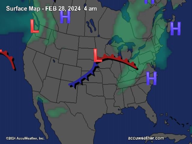
The National Weather Service in Sterling Virginia has issued a
Wind Advisory…which is in effect from 1 PM Sunday to 10 am EST
Monday.
West winds will begin to gust up to 50 mph Sunday afternoon…as a
deep low pressure system moves up the New England coast. These
strong wind gusts are expected to continue through mid morning
Monday. Sporadic power outages may result from downed trees and
power lines.
A Wind Advisory means that wind gusts up to 50 mph are expected.
Winds this strong can make driving difficult…especially for high
profile vehicles. Use extra caution.
The skies have finally opened up and light rain began falling Saturday afternoon just before dark. Upon the mountain, NCL Weather Watcher, John Taylor sent us this note about the weather up there:
Subject: WG WX
Date: December 15, 2007 4:14:07 PM EST
To: weather -at- nelsoncountylife.com
John Taylor wrote:
Foggy, misty, occasion light rain here on top. 24 degrees. Roads just now
getting slick — reports of Blue Ridge Drive (near golf and condos) starting to
ice — but they have units out working.
You can check out all of the various Winter Storm / Advisories and Ice Storm Warnings by checking out the graphic above and clicking on the associated hyperlinks that are highlighted. As just mentioned, much of the day higher elevations have been seeing freezing rain and sleet on the mountains. The temperature at NCL-Wintergreen Nature Foundation hovered around the 20° mark for most of the day, while valley temps hung around the mid 30’s. Obviously on the mountains they are the most prone to more serious icing because of the temperatures. You can see the estimated ice & snowfall amounts in the lower graphics for the next several hours. As I mentioned in earlier updates, this unfortunately appears to be more of an icing event vs a snow event. There’s going to be a critical period from roughly 6 PM Saturday until 6AM Sunday where we could pick up some ice.
There’s a period in there where valley temperatures may briefly dip to or slightly below freezing, but then rebound after midnight. Dewpoints in the valley are in the mid 20’s right now, so we could drop temperature wise to around 30° or so as the air moistens up. (Air temperatures can never drop below the dewpoint, so that is a good indicator as to how low the temps can drop – when dewpoint and temps are the same you have 100% humidity or saturation = rain or some kind of precip) That would allow for a few hours of icing as the rain moves in. On the mountains, you are already getting freezing rain and are essentially under a Winter Storm Warning until 1PM Sunday. The actual line ends at Augusta and the converts to a Winter Weather Advisory in Nelson, but since the Blue Ridge Parkway, Wintergreen, and Montebello all are on that BRP ridge, that skews things a bit.
Again, the bottom line on it all. Look for rain to begin changing to freezing rain in the valley of Nelson. The mountains stand to have the greatest impact from this event. Little snow is going to fall there. As of 5:00 PM as this forecast was being prepared, our NCL-Nelson County Life Weathernet station is indicating 33.6°. About a 1 degree drop in the past hour. We should hit the freezing mark in the next few hours and hover there until after midnight. That’s when temps should begin rising again and inch above the freezing mark. Look for this to last much longer on the mountains since they are much much colder there.
This will linger into the early morning daylight hours Sunday, then look for sunny conditions to return by afternoon. It will be very windy with speeds gusting to 50+ MPH on the mountains and around 40 MPH at times in the valley.
Should conditions worsen overnight I will be updating here with any bulletins, road conditions, and the like.
And for those of you keeping score at home check the detailed numbers below at any of our reporting NCL-Weathernet Stations for real up to the minute live weather data and detailed information including highs, lows, wind speeds, rainfall and much, much more.
Your Nelson County Life custom area forecast including: Wintergreen, Lovingston, & Tyro
TonightWinter Weather Advisory until 7 AM – snow, sleet, and freezing rain, eventually changing to rain after midnight.
* Lows Valley: 30-33° then slowly rising after midnight.
*On the mountains: 21-24° – Winter Storm Warning until 1PM Sunday : Sleet and freezing rain likely, 1/4 inch ice accumulations possible. Temps rising after midnight then rain.
*Winds: NE 10-15 MPH
SundayWinter Weather Advisory expires 7AM – Light freezing rain early then sunny by afternoon. Windy & cold.
* Highs Valley: 44-47°
*On the mountains: 30-33° Winter Storm Warning until 1PM – Rain and freezing rain early then partly sunny afternoon. Windy & cold, with snow showers
*Winds: NW 15-25 MPH by afternoon with gusts to 40 MPH valley and 50 MPH mountains.
Sunday night Partly cloudy, windy and colder with valley lows mid 20’s and mountains upper teens to near 20. Again gusty winds to near 40 MPH early decreasing to 15-20 MPH after midnight with gusts to near 30 MPH.
The start of next week continues cold, but sunny with valley highs in the mid 40’s and mountains low 30’s with occasional gusty winds.
There’s a chance of rain back in the forecast by Thursday.
Again, continue to check back here often for the latest updates.
Breaking news, breaking weather, whatever the case, we’ll have it all here.
We went from the feeling of the tropics to the tundra in about 24 hours as cold has moved back into Central Virginia, Before I get too far into all of the winter weather talk today, let me say a good morning to Helen, Louise and Alice Ferrall over in Batesville. Their mom, Elizabeth, tells me they have been hanging on our every word here in the NCL forecast center… okay, well more like a desk with a beagle asleep on the couch, but anyway … They have been looking every morning as the storm develops for our area and are wanting to know what everyone else does, will it snow?
It is becoming clearer as to how the winter storm will affect our area and we certainly will be able to define it as we go throughout the day today. I will be updating the information today and issuing new forecasts throughout the weekend as the storm progresses.
I wish I has better news, but it appears that our area could see more of an icing event vs snow, in particular in the valley. The mountains will see their share of it as well, but there is a better chance to see snow in the upper levels. It all boils down to how much warm air is aloft when the moisture arrives. I am pretty confident we will have freezing temperatures here at the surface, (Saturday night) but if the moisture falls down here as rain, you know what happens when it hits the surface, ice! As we go through Friday it will become more clear as to what conditions will be in place. As I mentioned yesterday and Wednesday, the bulk of the energy appears to be headed for NE of Virginia, but we should see a a significant winter event, at least from weather data available now.
Friday will be a fantastic day with sunny skies and mild temperatures, but clouds roll in Friday night in advance of snow, sleet and freezing rain that will start Saturday. We’ll see chances of frozen precip Saturday morning, but it will increase in intensity Saturday afternoon and Saturday night. The most likely time for intense snow, sleet and freezing rain is from roughly 3PM Saturday afternoon through Sunday morning. That’s not to say we won’t see it before that, but it is most likely to become intense in that time frame.
Right now I still see nothing that would prevent at least a fairly significant icing event, and as far as snow goes, 1-3 inches seems reasonable at the moment, but again I will update this later today.
And for those of you keeping score at home check the detailed numbers below at any of our reporting NCL-Weathernet Stations for real up to the minute live weather data and detailed information including highs, lows, wind speeds, rainfall and much, much more.
Your Nelson County Life custom area forecast including: Wintergreen at Black Rock Market, Faber at Delfosse Winery & The Arrington Post Office
*Today Sunny and pleasant.
* Highs Valley: 54-57°
*On the mountains: 44-47°
*Winds: SW-5 MPH
Tonight Partly cloudy early evening then mostly cloudy late.
* Lows Valley: 31-34°
*On the mountains: 24-27°
*Winds: N 5-10 MPH
Saturday Cloudy with rain, freezing rain and sleet developing by afternoon.
* Highs Valley: 36-39°
*On the mountains: 29-32° Snow, sleet, and freezing rain developing
*Winds: NE 5-10 MPH
Saturday night Rain, freezing rain and sleet likely. Significant ice accumulation possible.
* Lows Valley: 29-32°
*On the mountains: 24-27° – Snow sleet and freezing rain likely, significant accumulations possible
*Winds: NE 5-10 MPH
Sunday Rain, freezing rain, and snow likely in the morning, tapering off in the afternoon and becoming very windy – High Sun valley near 40° – On the mountains: Lower 30’s
Sunday night Partly cloudy and colder with valley lows low 20’s and mountains mid teens.
The start of next week continues cold, but sunny with valley highs in the low 40’s and mountains mid 30’s
Again, continue to check back here often for the latest updates on the developing winter storm this weekend. Any change in the path of this storm can dramatically affect what kind and how much wintry weather we get.
Breaking news, breaking weather, whatever the case, we’ll have it all here.
The National Weather Service continues to watch a developing winter storm system this evening. Below the snowfall map you will see the afternoon hazardous weather outlook for the Nelson / Central Virginia area. Interesting parts are highlighted in bold print.
The complete forecast out at 12:01 AM Friday morning.
-T-
HAZARDOUS WEATHER OUTLOOK – UPDATED
NATIONAL WEATHER SERVICE BALTIMORE MD/WASHINGTON DC
904 PM EST THU DEC 13 2007
THIS HAZARDOUS WEATHER OUTLOOK IS FOR MARYLAND WEST OF THE
EASTERN SHORE INCLUDING THE CHESAPEAKE BAY AND EAST OF GARRETT
COUNTY…EASTERN WEST VIRGINIA…NORTHERN AND CENTRAL VIRGINIA…
WASHINGTON DC AND THE TIDAL POTOMAC RIVER.
.DAY ONE…THIS AFTERNOON AND TONIGHT
NO HAZARDOUS WEATHER IS EXPECTED AT THIS TIME.
.DAYS TWO THROUGH SEVEN…FRIDAY THROUGH WEDNESDAY
A SIGNIFICANT WINTER STORM WILL IMPACT THE REGION BEGINNING
SATURDAY AND CONTINUING THROUGH SUNDAY. THE EXACT TIMING…TRACK
AND STRENGTH DETAILS ASSOCIATED WITH THIS STORM REMAIN UNCERTAIN
AT THIS TIME…HOWEVER IT IS LIKELY THAT AT LEAST A PORTION OF
THE REGION WILL EXPERIENCE SIGNIFICANT WINTRY PRECIPITATION.
CLIMATOLOGICALLY FAVORED LOCATIONS FOR WINTRY PRECIPITATION ARE
AREAS WEST OF INTERSTATE 81…WITH A VERY TIGHT GRADIENT OF A
WINTRY MIX OF PRECIPITATION ALONG THE I-95 CORRIDOR ASSOCIATED
WITH THE COASTAL FRONT…AND RAIN CLOSER TO SOUTHERN MARYLAND AND
KING GEORGE COUNTY VIRGINIA. CONFIDENCE ON WHERE THE COASTAL FRONT
SETS UP WILL LIKELY NOT BE HIGHER UNTIL FRIDAY…BUT ALL INTERESTS
IN THE REGION SHOULD BE ON ALERT FOR FUTURE UPDATES ON THIS
WEEKEND WINTER STORM.
GUSTY NORTHWEST WINDS BEHIND THIS WINTER STORM MAY REQUIRE GALE
WARNINGS ACROSS THE MARINE WATERS LATE SATURDAY NIGHT THROUGH
SUNDAY NIGHT AND GUSTS TO 40 MPH WILL BE POSSIBLE OVER THE LAND
AREAS.
From Thursday morning’s 11:15 AM National Weather Service Forecaster Discussion:
As is common across our County Warning Area…the rain/snow line will set up across
the County Warning Area…but exactly where it sets up and/or how it moves during
the storm is yet to be determined. This will will dictate who gets
how much of what precipitation type. Regardless…quantitative precipitation forecast is forecast to
be Bountiful with this storm. In addition…at least a portion of
our County Warning Area will receive wintry precipitation. Therefore…this storm
has the potential to be a high impact event across the County Warning Area. The most
likely scenario based on climatology…experience and GFS/ECMWF/sref
blends is for snow (or snow/sleet) at the onset…then for areas
west of the Blue Ridge to remain mostly snow for the duration while
other places experience a messy wintry mix that would include
freezing rain. The best chance of a total changeover to rain would
occur across lower southern Maryland and the Middle Bay. As the storm
re-develops of the middle Atlantic coast…mixed precipitation would
likely transition back to snow toward the end of the event Sunday
morning.
Because of a potential major winter storm headed our way, we’re foregoing weather pictures We’ve been talking about a developing winter storm over the weekend for the past day or so with lots of changing weather in between, so let’s get right into it shall we! First, how about Wednesday, wow, what a nice day, but a really warm one. Here at NCL-Nelson County Life Magazine in Greenfield we reached an afternoon high of 80° at 12:46 PM. Upon the mountain at NCL-Wintergreen Nature Foundation at Devil’s Knob, the afternoon high made it to a mild 62° at 10:43 AM. Other reporting NCL Weathernet stations were in the upper 70’s to near 80 as well. We can say good-bye to those temperatures and by this weekend we will be back in the deep freeze into early next week.
In the graphic above you can see we have the shot at some wintry weather this weekend. Early models show much of the energy concentrating to the NE of Virginia, but as the models continue to run we’ll have to see. It still looks like Central Virginia has the chance for a significant winter weather event. Unfortunately, the valley may actually see an icing event in addition to snow. Upon the mountains you have a better chance of seeing just plain snow. Though a little change in the warm air layer above could make it ice on the mountains as well. It’s way to soon to know right now, you just can’t predict this far out, but a 1-3 inch probability of snow is a good bet. BUT, a slight variation in the track of the storm could mean double or even triple that amount, or none. It’s why you always hear me laugh about these extended predictions, it just changes way too much to be accurate more than 12-24 hours out. As we get closer to the weekend I will more closely examine the snow / ice potential.
The mountains will have a shot at some wintry weather even as early as tonight. Some areas even saw some frozen precip last night, but nothing major. As colder air works in the area a snow / rain mix may occur on the mountains at places like Wintergreen Thursday night, again this won’t be much, but the weekend is a much different picture. Colder air already started filtering in last night, we get very cold by Saturday, Sunday into Monday.
As I said I’ll be watching this much more closely now as we get to within 48 hours of the possible storm event, check here often for updates.
And for those of you keeping score at home check the detailed numbers below at any of our reporting NCL-Weathernet Stations for real up to the minute live weather data and detailed information including highs, lows, wind speeds, rainfall and much, much more.
Your Nelson County Life custom area forecast including: Lovingtson, Wintergreen & Greenwood
*Today Cloudy with rain showers more likely in the afternoon. Much cooler than yesterday!
* Highs Valley: 44-47°
*On the mountains: 39-41° – Rain possibly mixed with sleet early morning.
Winds: SE 5-10 MPH becoming SW in the afternoon.
Tonight Early evening showers then becoming partly cloudy. Colder
* Lows Valley: 34-37°
*On the mountains: 28-31° – Some snow may mix with rain before ending
Winds: W 5-10 MPH
Friday night Partly cloudy early evening, then becoming mostly cloudy.
* Lows Valley: 30-33°
*On the mountains: 25-28°
*Winds: NE-5 MPH
Saturday Rain, freezing rain, and snow likely in the valley, beginning around noon and increasing afternoon. More snow likely mountains, but ice cannot be ruled out at this time. THIS COULD BE A SIGNIFICANT ICING EVENT – FORECASTS SHOULD BE CLOSELY MONITORED FOR CHANGES High Sat valley upper 30’s – On the mountains: Lower 30’s
Saturday night look for the wintry mix to continue with valley lows around 30° and mountains low to mid 20’s.
By Sunday look for the snow, rain and freezing rain mix to continue tapering off by late afternoon. Highs in the upper 30’s valley and highs around 30 mountains.
Next week look for very cold temperatures to move back in with overnight lows in the mid teens on the mountains and around 20 valley.
Again, continue to check back here often for the latest updates on the developing winter storm this weekend.
Breaking news, breaking weather, whatever the case, we’ll have it all here.
Hang on folks, it’s going to be an interesting couple of days leading up to the weekend. This is where the weather guys earn their money trying to figure out what will take place with a developing winter storm for the weekend. I remember when I was doing television weather some years ago. This was always a time of great anxiety and anticipation as we tried to figure out what would happen a few days out. There’s not much reason to get too detailed this far out, but it’s worth saying that most weather folks are keeping an eye on this potential storm for the weekend.
We have one more day of mild weather before we begin to see significant changes taking place. Wednesday will be fairly mild, warmer than Tuesday. Clouds hung in there and kept temps in the upper 50’s to near 60 yesterday. We’ll warm a little more today before starting a cool down as we head toward the weekend. Rain chances increase as we go through the day Wednesday, with best chances Wednesday night into Thursday when the best chance of rain looms. Friday will be a relatively quiet day before winter changes start happening Friday night into the remainder of the weekend. Right now it appears Saturday and Sunday have a decent shot at snow and or ice, with the best chances for snow at Wintergreen, The BRP, Montebello, and other areas along or near the parkway. Depending on temps we could see a significant icing event in the valley. AGAIN, I emphasize , it’s still a long way out to know exactly what will happen. But at least initially, it looks favorable for a significant winter storm this coming weekend. You can click here to see my post from yesterday that has a couple of AccuWeather.com predictions on amounts for Saturday. These will be updated later today as well.
Keep checking back here from time to time over the next couple of days as I will be updating when information and forecasts become available.
And for those of you keeping score at home check the detailed numbers below at any of our reporting NCL-Weathernet Stations for real up to the minute live weather data and detailed information including highs, lows, wind speeds, rainfall and much, much more.
Your Nelson County Life custom area forecast including: Nellysford, Faber & Crozet
*Today Patchy dense fog early, then partly sunny with isolated showers, then cloudy in the afternoon with scattered rain showers. Mild.
* Highs Valley: 67-70°
*On the mountains: 57-60°
Winds: W 10-15 MPH
Tonight Cloudy with showers early evening then better chances of rain after midnight.
* Lows Valley: 38-41°
*On the mountains: 34-37° (Some light wet snow may occur overnight, but no accumulation expected)
Winds: NE 5-10 MPH
Tomorrow Cloudy and rainy throughout the day.
* Highs Valley: 46-49°
*On the mountains: 40-43°
*Winds: E 3-5 MPH
Tomorrow night Mostly cloudy with rain ending by midnight, becoming partly cloudy and cold.
* Lows Valley: 34-37°
*On the mountains: 28-31° (again some frozen precip may occur mountains as the rain ends)
*Winds: W-5 MPH
The remainder of the week Friday looks mostly sunny with highs in the lower 50’s valley and lower 40’s mountains.
By Saturday and Sunday look for snow to develop. Freezing rain is a possibility in lower elevations and points south. Snow should continue into Sunday morning. At this point a decent snow / ice event is possible. Continue to check back here often for the latest updates.
Breaking news, breaking weather, whatever the case, we’ll have it all here.
Above, crews out of Roanoke hoist antenna cables to the top of a newly installed monopole behind the Wintergreen Fire Department in Stoney Creek. The structure will greatly improve cellular service for AT&T wireless users in the area.
NCL can confirm that improved cellular service is on the way for at least part of Nelson County with a much greater improvement coming in 2008. Crews have been working to get a new monopole structure and the electronics completed for AT&T Wireless. The transmitter will be located behind the Wintergreen Fire Department in Stoney Creek with an expected competition date at the end of December. “They are telling it will be active and ready for use by the end of this month,” says Curtis Sheets, Chief of Wintergreen Fire & Rescue. Curtis is coordinating the installation of the equipment and making sure every modification is signed off by him before any work is completed. “This is significant for the fire and rescue as well. We will finally be able to put a much needed repeater on this monopole that will increase our radio coverage here in the valley. Right now we have several radio dead spots up near the mountain and this will help eliminate those,” Curtis continues.
Bad cellular service is something most Nelson County residents have grown accustomed to, knowing their signal will drop out sometime, somewhere. The AT&T wireless system will help improve service for their customers in the Nellysford area, but in other parts of the county it won’t be much help. However, Verizon Wireless is undertaking an aggressive plan to install numerous sites across Nelson County to essentially cover the entire area with reliable cellular service. If the system is like other Verizon Wireless systems in the country, it would have Verizon Broadband wireless capability when completed.
Verizon Wireless has been negotiating with various land owners across the county to secure long term leases for placement of equipment. All of the sites including the AT&T site in Nellysford are using low profile monopole (a slim pole with no tension wires attached) structures to better blend into the area and be less conspicuous. NCL knows of several land owners from Piney River to Afton and beyond that have been contacted by Verizon Wireless to work out land leases. Several have already made their way through regulatory channels.
Once completed the system should provide much more reliable wireless service to customers in the Nelson area in the valley and on the mountains.
There’s a lot of discussion going on in the background today about a possible developing winter storm for the weekend here in Central Virginia. As I mentioned in today’s forecast, the potential exists for snow this weekend.
Forecasters in the NWS office in Sterling made this mention in their morning weather discussion:
Guidance now in very good agreement in developing a potentially sig
winter storm during the second half of the weekend in response to
deepening trough over the middle of the country Friday. However…guidance
remains somewhat split with gefs/NCEP means indicating a more of a
southern track (snow)from the southeast coast to cape hatteas and out to
sea while European model (ecmwf) is more robust and much slower indicating a 500 mb
closed low and a track further inland suggesting the possibility of
more of a mixed precipitation/rain event.
As I always say, if you are predicting more than 12-24 hours don’t depend on it, but this does at least raise my eyebrows and much of the data I see right now supports it. I’ll have more in the Wednesday weathercast out at 12:01 AM Wednesday. This event could last into Sunday as well.