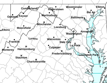
Via NWS: The areas highlighted in orange are under a heat advisory Thursday afternoon until 8PM.
Heat Advisory – CANCELED
Statement as of 7:58 PM EDT on July 26, 2012
…Heat advisory is cancelled…
The National Weather Service in Baltimore MD/Washington has
cancelled the heat advisory.
HEAT ADVISORY NOON THURSDAY UNTIL 8 PM THURSDAY URGENT – WEATHER MESSAGE
NATIONAL WEATHER SERVICE BALTIMORE MD/WASHINGTON DC
345 PM EDT WED JUL 25 2012
…HEAT ADVISORY NOON THURSDAY UNTIL 8 PM THURSDAY…
NELSON-ALBEMARLE-GREENE-
INCLUDING THE CITY OF…CHARLOTTESVILLE
345 PM EDT WED JUL 25 2012
…HEAT ADVISORY IN EFFECT FROM NOON TO 8 PM EDT THURSDAY…
THE NATIONAL WEATHER SERVICE IN BALTIMORE MD/WASHINGTON HAS
ISSUED A HEAT ADVISORY…WHICH IS IN EFFECT FROM NOON TO 8 PM EDT
THURSDAY.
* HEAT INDEX VALUES…AROUND 105 DEGREES.
* MAXIMUM TEMPERATURES…UPPER 90S EAST OF THE BLUE RIDGE.
* IMPACTS…TAKE EXTRA PRECAUTIONS IF YOU WORK OR SPEND TIME
OUTSIDE. WHEN POSSIBLE…RESCHEDULE STRENUOUS ACTIVITIES TO
EARLY MORNING OR EVENING. KNOW THE SIGNS AND SYMPTOMS OF HEAT
EXHAUSTION AND HEAT STROKE. WEAR LIGHT WEIGHT AND LOOSE FITTING
CLOTHING WHEN POSSIBLE AND DRINK PLENTY OF WATER.
PRECAUTIONARY/PREPAREDNESS ACTIONS…
A HEAT ADVISORY MEANS THAT A PERIOD OF HOT TEMPERATURES IS
EXPECTED. THE COMBINATION OF HOT TEMPERATURES AND HIGH HUMIDITY
WILL COMBINE TO CREATE A SITUATION IN WHICH HEAT ILLNESSES ARE
POSSIBLE. DRINK PLENTY OF FLUIDS…STAY IN AN AIR-CONDITIONED
ROOM…STAY OUT OF THE SUN…AND CHECK IN ON RELATIVES AND
NEIGHBORS.
Afton
Nelson County, VA As we first reported this past Sunday July 22, 2012 a serious traffic accident on Route 151 at Tanbark Drive caused the death of one person that day. We began learning Tuesday night the news was probably not good for the husband of the person killed on Sunday. His wife Rita Beaulieu was killed at the scene.
An inquiry to NCL from television station WJAR NBC-10 in Rhode Island was trying to confirm that husband, 76 year old Alphonse Beaulieu had also passed away on Tuesday. They received unofficial confirmation that night. We worked to confirm the information but were unable to until Wednesday afternoon. VSP told CBS -19 there were no changes Tuesday evening, and our inquires to both Nelson Commonwealth Attorney Anthony Martin and Nelson Sheriff Brooks were not able to immediately confirm the information.
According to our media partners at CBS-19 in Charlottesville Wednesday:
The driver of the motorcycle involved in Sunday’s Nelson County crash passed away Tuesday afternoon (July 24) at UVa Hospital.
The crash remains under investigation and charges are still pending.
As storms moved south and east out of Wisconsin a Derecho formed Tuesday, but never made it to Nelson. Isolated severe storms broke out, but nothing organized here.
Be sure to follow us on Facebook and Twitter for additional updates as well.
Nelson County, VA
After a fairly mild weekend with rain showers on Saturday, (the high temp on Saturday only reached 74°) then some sunshine on Sunday, we will head back to a chance for those afternoon showers and thunderstorms starting Monday. Temps will be heading back up as well with everyday this week with temps generally 90° or above.
There’s a better than average chance of severe weather on Tuesday afternoon. Listen Below to hear Tommy discuss Tuesday’s forecast.
Lovingston
Nelson County, VA
Despite the rain falling outside, folks got a great meal and had a good time inside at the Lovingston Volunteer Fire Department’s Community Picnic. “The purpose of the picnic was to reach out to the community and get more people involved in firefighting,” Fire Chief Bruce Johnson told Paul when he was there snapping pics.
The LVFD will be holding other events in the month of August, including their 13th Annual Dice Run & Bike Show & 1st Annual Swap Meet, along with a
Dinner and a Square Dance.You can click here to see more details and check them out!
One woman was killed and four others were injured in a two-vehicle crash Sunday afternoon in Nelson County. Virginia State Police Trooper R. Sachno III is investigating the crash.
The driver of the motorcycle, Alphonse R. Beaulieu, 76, of North Smithfield, Rhode Island, is currently being treated at UVa Hospital for life-threatening injuries. His wife and passenger, Rina I. Beaulieu, 75, of North Smithfield, Rhode Island, died at the scene. Both were wearing helmets.
The investigation into the crash remains ongoing at this time. Alcohol was not a factor in the crash. Charges are pending consultation with the Commonwealth’s Attorney.
One person is dead and several others were treated after an accident at the intersection of Tanbark Drive and Route 151 in Afton. The wreck between a motorcycle and a car happened around 4PM Sunday afternoon.
A woman, who was a passenger on the motorcycle, died in the crash. A man, who was also on the motorcycle, was airlifted to the U.Va. Medical Center. We are told they are not from Virginia.
There were also injuries from the passengers in the car.
A Virginia State Police crash reconstruction team is working to determine the exact cause of the crash
Via NWS: A Flash Flood Watch remins in effect into Friday evening for the areas highlighted in green.
Flood Watch / Flood Statement
Statement as of 9:30 PM EDT on July 20, 2012
…Flash Flood Watch is cancelled…
The Flash Flood Watch for portions of Maryland…the District of
Columbia…Virginia and northeast West Virginia has been
cancelled.
Showers…some briefly heavy…will continue through the evening
but widespread heavy rainfall is not expected.
FLOOD WATCH
NATIONAL WEATHER SERVICE BALTIMORE MD/WASHINGTON DC
1108 AM EDT FRI JUL 20 2012
DISTRICT OF COLUMBIA-WASHINGTON-FREDERICK MD-CARROLL-
NORTHERN BALTIMORE-HARFORD-MONTGOMERY-HOWARD-SOUTHERN BALTIMORE-
PRINCE GEORGES-ANNE ARUNDEL-CHARLES-ST. MARYS-CALVERT-
EXTREME WESTERN ALLEGANY-CENTRAL AND EASTERN ALLEGANY-AUGUSTA-
ROCKINGHAM-SHENANDOAH-FREDERICK VA-PAGE-WARREN-CLARKE-NELSON-
ALBEMARLE-GREENE-MADISON-RAPPAHANNOCK-LOUDOUN-ORANGE-CULPEPER-
PRINCE WILLIAM/MANASSAS/MANASSAS PARK-FAIRFAX-
ARLINGTON/FALLS CHURCH/ALEXANDRIA-STAFFORD-SPOTSYLVANIA-
KING GEORGE-NORTHERN FAUQUIER-SOUTHERN FAUQUIER-WESTERN HIGHLAND-
EASTERN HIGHLAND-HAMPSHIRE-MORGAN-BERKELEY-JEFFERSON-HARDY-
WESTERN GRANT-EASTERN GRANT-WESTERN MINERAL-EASTERN MINERAL-
WESTERN PENDLETON-EASTERN PENDLETON-
INCLUDING THE CITIES OF…WASHINGTON…HAGERSTOWN…FREDERICK…
WESTMINSTER…GAITHERSBURG…COLUMBIA…BALTIMORE…ANNAPOLIS…
WALDORF…ST MARYS CITY…FROSTBURG…CUMBERLAND…STAUNTON…
WAYNESBORO…HARRISONBURG…WINCHESTER…FRONT ROYAL…
CHARLOTTESVILLE…LEESBURG…CULPEPER…MANASSAS…
MANASSAS PARK…FAIRFAX…ALEXANDRIA…FALLS CHURCH…
FREDERICKSBURG…WARRENTON…HIGHTOWN…MONTEREY…MARTINSBURG…
CHARLES TOWN…MOOREFIELD…BAYARD…MOUNT STORM…PETERSBURG…
ELK GARDEN…KEYSER…FORT ASHBY…CIRCLEVILLE…FRANKLIN
1108 AM EDT FRI JUL 20 2012
…FLASH FLOOD WATCH REMAINS IN EFFECT UNTIL 11 PM EDT THIS
EVENING…
* UNTIL 11 PM EDT THIS EVENING
* WIDESPREAD RAINFALL RATES OF ONE TO TWO INCHES PER HOUR CAN BE
EXPECTED FROM AFTERNOON AND EVENING THUNDERSTORMS.
* EXCESSIVE RAINFALL COULD CAUSE CREEKS AND STREAMS TO RISE
QUICKLY OUT OF THEIR BANKS AND COULD FLOOD LOW-LYING AND URBAN
AREAS…PARTICULARLY THOSE THAT HAVE HAD RECENT SIGNIFICANT
RAINFALL.
PRECAUTIONARY/PREPAREDNESS ACTIONS…
A FLASH FLOOD WATCH MEANS THAT CONDITIONS MAY DEVELOP THAT LEAD
TO FLASH FLOODING. FLASH FLOODING IS A VERY DANGEROUS SITUATION.
YOU SHOULD MONITOR LATER FORECASTS AND BE PREPARED TO TAKE ACTION
SHOULD FLASH FLOOD WARNINGS BE ISSUED.
Via NWS: A Severe Thunderstorm Watch is in effect for much of Central and Northern Virginia, including Nelson & Wintergreen until 9PM Wednesday night.
Cancellation
Severe Thunderstorm Watch
Statement as of 8:38 PM EDT on July 18, 2012
The National Weather Service has cancelled Severe Thunderstorm
Watch 491 for the following areas
In Virginia this cancels 11 counties
In central Virginia
Albemarle Greene Nelson
In northwest Virginia
Madison Page Rappahannock
Shenandoah Warren
In western Virginia
Augusta Highland Rockingham
In West Virginia this cancels 3 counties
In northeast West Virginia
Grant Hardy Pendleton
In Virginia this cancels 4 independent cities
In central Virginia
Charlottesville
In northwest Virginia
City of Harrisonburg
In western Virginia
City of Staunton City of Waynesboro
SEVERE THUNDERSTORM WATCH NUMBER 491 URGENT – IMMEDIATE BROADCAST REQUESTED
SEVERE THUNDERSTORM WATCH NUMBER 491
NWS STORM PREDICTION CENTER NORMAN OK
1245 PM EDT WED JUL 18 2012
THE NWS STORM PREDICTION CENTER HAS ISSUED A
SEVERE THUNDERSTORM WATCH FOR PORTIONS OF
DISTRICT OF COLUMBIA
DELAWARE
MARYLAND
NEW JERSEY
SOUTHEAST NEW YORK
CENTRAL AND EASTERN PENNSYLVANIA
NORTHERN VIRGINIA
EASTERN WEST VIRGINIA PANHANDLE
COASTAL WATERS
EFFECTIVE THIS WEDNESDAY AFTERNOON AND EVENING FROM 1245 PM UNTIL
900 PM EDT.
HAIL TO 1.5 INCHES IN DIAMETER…THUNDERSTORM WIND GUSTS TO 70
MPH…AND DANGEROUS LIGHTNING ARE POSSIBLE IN THESE AREAS.
THE SEVERE THUNDERSTORM WATCH AREA IS APPROXIMATELY ALONG AND 80
STATUTE MILES EAST AND WEST OF A LINE FROM 55 MILES EAST OF
STAUNTON VIRGINIA TO 25 MILES EAST NORTHEAST OF WILKESBARRE
PENNSYLVANIA. FOR A COMPLETE DEPICTION OF THE WATCH SEE THE
ASSOCIATED WATCH OUTLINE UPDATE (WOUS64 KWNS WOU1).
REMEMBER…A SEVERE THUNDERSTORM WATCH MEANS CONDITIONS ARE
FAVORABLE FOR SEVERE THUNDERSTORMS IN AND CLOSE TO THE WATCH
AREA. PERSONS IN THESE AREAS SHOULD BE ON THE LOOKOUT FOR
THREATENING WEATHER CONDITIONS AND LISTEN FOR LATER STATEMENTS
AND POSSIBLE WARNINGS. SEVERE THUNDERSTORMS CAN AND OCCASIONALLY
DO PRODUCE TORNADOES.
OTHER WATCH INFORMATION…CONTINUE…WW 490…
DISCUSSION…TSTMS ARE EXPECTED TO INCREASE IN COVERAGE AND
INTENSITY THIS AFTERNOON AHEAD OF COLD FRONT AND LEE TROUGH.
AMBIENT WARM SECTOR IS HOT AND HUMID WITH MLCAPE VALUES OF
2000-3000+ J/KG. WHEN COUPLED WITH STEEPENING LOW-LEVEL LAPSE RATES
AND HIGH PW VALUES…SETUP WILL FAVOR THE DEVELOPMENT OF INTENSE WET
MICROBURSTS CAPABLE OF DAMAGING WINDS.
AVIATION…A FEW SEVERE THUNDERSTORMS WITH HAIL SURFACE AND ALOFT
TO 1.5 INCHES. EXTREME TURBULENCE AND SURFACE WIND GUSTS TO 60
KNOTS. A FEW CUMULONIMBI WITH MAXIMUM TOPS TO 500. MEAN STORM
MOTION VECTOR 31020.
County City Outline Area SEVERE THUNDERSTORM WATCH OUTLINE UPDATE FOR WS 491
NWS STORM PREDICTION CENTER NORMAN OK
1245 PM EDT WED JUL 18 2012
SEVERE THUNDERSTORM WATCH 491 IS IN EFFECT UNTIL 900 PM EDT
FOR THE FOLLOWING LOCATIONS
ALBEMARLE ARLINGTON AUGUSTA
CLARKE CULPEPER FAIRFAX
FAUQUIER FREDERICK GREENE
HIGHLAND KING GEORGE LOUDOUN
MADISON NELSON ORANGE
PAGE PRINCE WILLIAM RAPPAHANNOCK
ROCKINGHAM SHENANDOAH SPOTSYLVANIA
STAFFORD WARREN
VIRGINIA INDEPENDENT CITIES INCLUDED ARE
ALEXANDRIA CHARLOTTESVILLE FAIRFAX
FALLS CHURCH FREDERICKSBURG HARRISONBURG
MANASSAS MANASSAS PARK STAUNTON
WAYNESBORO WINCHESTER
$$
Via NWS: The areas shaded in orange are under a heat advisory for most of Wednesday. This includes Nelson & Wintergreen.
HEAT ADVISORY IN EFFECT FROM 11 AM TO 9 PM EDT WEDNESDAY
URGENT – WEATHER MESSAGE
NATIONAL WEATHER SERVICE BALTIMORE MD/WASHINGTON DC
140 PM EDT TUE JUL 17 2012
DISTRICT OF COLUMBIA-FREDERICK MD-CARROLL-NORTHERN BALTIMORE-
HARFORD-MONTGOMERY-HOWARD-SOUTHERN BALTIMORE-PRINCE GEORGES-
ANNE ARUNDEL-CHARLES-ST. MARYS-CALVERT-NELSON-ALBEMARLE-GREENE-
MADISON-RAPPAHANNOCK-LOUDOUN-ORANGE-CULPEPER-
PRINCE WILLIAM/MANASSAS/MANASSAS PARK-FAIRFAX-
ARLINGTON/FALLS CHURCH/ALEXANDRIA-STAFFORD-SPOTSYLVANIA-
KING GEORGE-NORTHERN FAUQUIER-SOUTHERN FAUQUIER-
INCLUDING THE CITIES OF…WASHINGTON…FREDERICK…WESTMINSTER…
GAITHERSBURG…COLUMBIA…BALTIMORE…ANNAPOLIS…WALDORF…
ST MARYS CITY…CHARLOTTESVILLE…LEESBURG…CULPEPER…
MANASSAS…MANASSAS PARK…FAIRFAX…ALEXANDRIA…FALLS CHURCH…
FREDERICKSBURG…WARRENTON
140 PM EDT TUE JUL 17 2012
…HEAT ADVISORY IN EFFECT FROM 11 AM TO 9 PM EDT WEDNESDAY…
THE NATIONAL WEATHER SERVICE IN BALTIMORE MD/WASHINGTON HAS
ISSUED A HEAT ADVISORY…WHICH IS IN EFFECT FROM 11 AM TO 9 PM
EDT WEDNESDAY.
* HEAT INDEX VALUES…AROUND 105 DEGREES.
* MAXIMUM TEMPERATURES…AROUND 100 IN THE CITIES…UPPER 90S
ELSEWHERE EAST OF THE MOUNTAINS.
PRECAUTIONARY/PREPAREDNESS ACTIONS…
A HEAT ADVISORY MEANS THAT A PERIOD OF HOT TEMPERATURES
IS EXPECTED. THE COMBINATION OF HOT TEMPERATURES AND HIGH
HUMIDITY WILL COMBINE TO CREATE A SITUATION IN WHICH HEAT
ILLNESSES ARE POSSIBLE. DRINK PLENTY OF FLUIDS…STAY IN AN
AIR-CONDITIONED ROOM…STAY OUT OF THE SUN…AND CHECK ON ELDERLY
RELATIVES AND NEIGHBORS. WEAR LIGHT WEIGHT AND LOOSE FITTING
CLOTHING WHEN POSSIBLE.
NEVER LEAVE SMALL CHILDREN OR PETS UNATTENDED IN VEHICLES.
TEMPERATURES INSIDE THE VEHICLE CAN RAPIDLY CLIMB TO 130 DEGREES.
TAKE EXTRA PRECAUTIONS IF YOU WORK OR SPEND TIME OUTSIDE.
WHEN POSSIBLE…RESCHEDULE STRENUOUS ACTIVITIES TO EARLY
MORNING OR EVENING. KNOW THE SIGNS AND SYMPTOMS OF HEAT
EXHAUSTION AND HEAT STROKE.
TO REDUCE RISK DURING OUTDOOR WORK…THE OCCUPATIONAL SAFETY
AND HEALTH ADMINISTRATION RECOMMENDS SCHEDULING FREQUENT
REST BREAKS. ANYONE OVERCOME BY HEAT SHOULD BE MOVED TO A COOL
AND SHADED LOCATION. HEAT STROKE IS AN EMERGENCY – CALL 9 1 1.
Afton
Nelson County, VA
The biking world lost one of its angels today. June Curry, known to cyclists around the world as “The Cookie Lady,” died Monday afternoon. She was born on February 8, 1921. June was best know for providing a place for cyclists to stop for a break, or stay overnight as they rode across the country.
Our story from the July 2005 issue of Nelson County Life Magazine on The Cookie Lady. Click photo to enlarge. Our son Adam placed a small vase of simple flowers at The Bike House Monday evening to remember June.
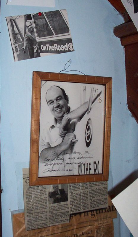
The subject of one of Charles Kuralt’s “On the Road” segments for CBS Sunday Morning, Curry gained fame and love for offering cyclists cookies and other treats as they passed her house along Afton Mountain Road.
A photo from our 2005 story on June Curry. Charles Kuralt autographed a picture for her after doing the story on The Cookie Lady. A nearby building, known as "The Bike House," became a favorite stopping point along US Bike Route 76, aka the Transamerica Route. The Bike House offered shelter for weary cyclists and , in turn, became a shrine to the sport.
Just a few of the thousands of postcards that hang in The Bike House from cyclists who have stayed with The Cookie Lady. What started it all. Cookies. When cyclists first came through decades ago, June first offered them cookies. The name stuck!
No word yet from June’s family on a service, but as for the bike house at 3240 Afton Mountain Road, the property’s owner, Hope Wood, plans to keep it as it is for cyclists.