
Wednesday: More Scattered T-Storms Near 90° : Dry Weekend – Tommy’s Weather

Wednesday: More Scattered T-Storms Near 90° : Dry Weekend – Tommy’s Weather
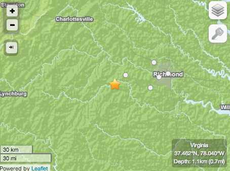
Near Powhatan, Virginia
The USGS is confirming that a 3.2 magitude earthquake hit in the Central Virginia region near Powhatan. According to the readings it was about 8 miles southwest of there.
“Heard and felt the rumbling here in Lovingston,” Laura Canody reported on our BRL Facebook page. Kelsey Vergin of Scottsville sent us a text saying she felt it there near the James River. “Rattled/Rumbled the doors here in Andersonville, Buckingham County,” Bobby Hudgins added on our Facebook timeline.
More as we know.

Devils Knob / Wintergreen
Nelson County, VA
For years and years The Nature Foundation At Wintergreen has been holding their very popular Spring Wildflower Symposium along with their Native Plant Sale. (Trivia: their 2005 symposium was the cover on our May issue of that year! – our second issue when we were just starting) Instructors for the weekend included well known botanists, authors, and artists, each prepared with a full weekend of activities and lectures.
To see more of Paul’s photos click on our Facebook album below.


Afton
Nelson County, VA
For years BandFair has been an annual event held at Cardinal Point Vineyard & Winery. It’s a main fundraiser for North Branch School in Afton. This past weekend with clear blue skies and perfect spring temperatures, the 2014 event went off without a hitch.
And our Shay Munroe grabbed some of the photos from there. Check all of them out in our Facebook album below!

Tyro
Nelson County, VA
The first in a series of events planned for this summer finished up over the weekend at Pharsalia in Tyro, Virginia. As we told you in this story earlier, the plantation was holding their Folk Life Festival to look back at what life was line in 1814 when it was founded.
See all of Shay’s photos above in our Facebook album.
To see the entire list of events planned for the 200 year celebration this summer, click on this link.

Tyro
Nelson County, VA
It takes a long time to get to where you can celebrate 200 years of anything! This weekend Pharsalia in Tyro will do just that. As we told you in our April 2014 cover story the plantation will hold its bicentennial Folk Life Festival starting Saturday – May 17th at 10AM and continuing on Sunday from 10AM until 4PM. This weekend’s festival is just one of several summer and fall events being held to celebrate the 200 year anniversary.
Blue Ridge Life Magazine is one of the sponsors for the celebration that ends up in October with Family Apple Harvest Day Spring

To read our April 2014 cover story on the 200 year celebration at Pharsalia click on our magazine article above.
For more information on the 200th birthday celebration at Pharsalia, click here.


Severe Thunderstorm Watch
Statement as of 3:50 PM EDT on May 15, 2014
The National Weather Service has cancelled Severe Thunderstorm
Watch 157 for the following areas
In Virginia this cancels 8 counties
In central Virginia
Albemarle Greene Nelson
In northwest Virginia
Madison Page Shenandoah
In western Virginia
Augusta Rockingham
In West Virginia this cancels 2 counties
In northeast West Virginia
Hampshire Hardy
In Virginia this cancels 4 independent cities
In central Virginia
Charlottesville
In northwest Virginia
City of Harrisonburg
In western Virginia
City of Staunton City of Waynesboro
This includes the cities of…Charlottesville…Greenfield…
Harrisonburg…Luray…Madison…Moorefield…Romney…
Stanardsville…Staunton…Strasburg…Waynesboro and Woodstock.
SEVERE THUNDERSTORM WATCH
The NWS Storm Prediction Center has issued a
* Severe Thunderstorm Watch for portions of
central Maryland
central and eastern North Carolina
central Virginia
eastern West Virginia Panhandle
coastal waters
* effective this Thursday morning and evening from 1155 am until
800 PM EDT.
* Primary threats include…
scattered damaging wind gusts to 70 mph possible
a tornado or two possible
The Severe Thunderstorm Watch area is approximately along and 60
statute miles east and west of a line from 10 miles west
northwest of Hagerstown Maryland to 40 miles west of Wilmington
North Carolina. For a complete depiction of the watch see the
associated watch outline update (wous64 kwns wou7).
Precautionary/preparedness actions…
Remember…a Severe Thunderstorm Watch means conditions are
favorable for severe thunderstorms in and close to the watch
area. Persons in these areas should be on the lookout for
threatening weather conditions and listen for later statements
and possible warnings. Severe thunderstorms can and occasionally
do produce tornadoes.
Discussion…a line of ongoing thunderstorms will intensify this
afternoon while shifting eastward through the Piedmont. Other storms
may form ahead of the squall line across the Piedmont and coastal
plains as the environment becomes moderately unstable. Wind shear
profiles will be supportive of embedded bowing structures and
supercells capable of damaging wind gusts and perhaps a tornado or
two.
Aviation…a few severe thunderstorms with hail surface and aloft
to 0.5 inch. Extreme turbulence and surface wind gusts to 60
knots. A few cumulonimbi with maximum tops to 500. Mean storm
motion vector 21025.

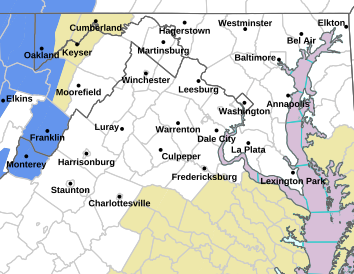
Flood Watch / Flood Statement
Statement as of 5:01 AM EDT on May 16, 2014
…Flash Flood Watch is cancelled…
The Flash Flood Watch for portions of central Virginia…northern
Virginia and northwest Virginia has been cancelled.
FLASH FLOOD WATCH IN EFFECT THROUGH FRIDAY
FLOOD WATCH
NATIONAL WEATHER SERVICE BALTIMORE MD/WASHINGTON DC
404 PM EDT THU MAY 15 2014
…FLASH FLOOD WATCH IN EFFECT THROUGH FRIDAY…
WASHINGTON-EXTREME WESTERN ALLEGANY-CENTRAL AND EASTERN ALLEGANY-
AUGUSTA-ROCKINGHAM-SHENANDOAH-FREDERICK VA-PAGE-WARREN-CLARKE-
WESTERN HIGHLAND-EASTERN HIGHLAND-HAMPSHIRE-MORGAN-BERKELEY-
JEFFERSON-HARDY-WESTERN GRANT-EASTERN GRANT-WESTERN MINERAL-
EASTERN MINERAL-WESTERN PENDLETON-EASTERN PENDLETON-
INCLUDING THE CITIES OF…HAGERSTOWN…FROSTBURG…CUMBERLAND…
STAUNTON…WAYNESBORO…HARRISONBURG…WINCHESTER…FRONT ROYAL…
HIGHTOWN…MONTEREY…MARTINSBURG…CHARLES TOWN…MOOREFIELD…
BAYARD…MOUNT STORM…PETERSBURG…ELK GARDEN…KEYSER…
FORT ASHBY…CIRCLEVILLE…FRANKLIN
404 PM EDT THU MAY 15 2014
…FLASH FLOOD WATCH REMAINS IN EFFECT THROUGH FRIDAY AFTERNOON…
THE FLASH FLOOD WATCH CONTINUES FOR
* THE FOLLOWING COUNTIES…IN MARYLAND…ALLEGANY AND WASHINGTON.
IN VIRGINIA…AUGUSTA…CLARKE…HIGHLAND…FREDERICK VA…
PAGE…ROCKINGHAM…SHENANDOAH…WARREN. IN NORTHEAST WEST
VIRGINIA…BERKELEY…GRANT…MINERAL…PENDLETON…HAMPSHIRE…
HARDY…JEFFERSON…MORGAN.
* THROUGH FRIDAY AFTERNOON
* SHOWERS AND SCATTERED THUNDERSTORMS WILL CONTINUE INTO FRIDAY
AFTERNOON. THE HEAVIEST RAIN WILL BE INTO TONIGHT. RAINFALL
AMOUNTS OF 2 TO 4 INCHES ARE EXPECTED…WITH LOCALLY HIGHER
AMOUNTS POSSIBLE. THIS AMOUNT OF RAINFALL HAS THE POTENTIAL TO
PRODUCE FLASH FLOODING… ESPECIALLY ALONG CREEKS AND STREAMS.
PRECAUTIONARY/PREPAREDNESS ACTIONS…
A FLASH FLOOD WATCH MEANS THAT CONDITIONS MAY DEVELOP THAT LEAD
TO FLASH FLOODING. FLASH FLOODING IS A VERY DANGEROUS SITUATION.
YOU SHOULD MONITOR LATER FORECASTS AND BE PREPARED TO TAKE ACTION
SHOULD FLASH FLOOD WARNINGS BE ISSUED.
FLOOD WATCH
NATIONAL WEATHER SERVICE BALTIMORE MD/WASHINGTON DC
404 PM EDT THU MAY 15 2014
…FLASH FLOOD WATCH IN EFFECT THIS AFTERNOON THROUGH FRIDAY…
NELSON-ALBEMARLE-GREENE-MADISON-RAPPAHANNOCK-ORANGE-CULPEPER-
SPOTSYLVANIA-NORTHERN FAUQUIER-SOUTHERN FAUQUIER-
INCLUDING THE CITIES OF…CHARLOTTESVILLE…WASHINGTON…
CULPEPER…FREDERICKSBURG…WARRENTON
404 PM EDT THU MAY 15 2014
…FLASH FLOOD WATCH NOW IN EFFECT THROUGH FRIDAY AFTERNOON…
THE FLASH FLOOD WATCH IS NOW IN EFFECT FOR
* THE FOLLOWING COUNTIES IN VIRGINIA…ALBEMARLE…GREENE…
NELSON…ORANGE… SPOTSYLVANIA…FAUQUIER…MADISON AND
RAPPAHANNOCK.
* THROUGH FRIDAY AFTERNOON
* LINES OF THUNDERSTORMS…WITH PERIODS OF HEAVY RAIN…ARE
EXPECTED TO CONTINUE THROUGH INTO FRIDAY AFTERNOON. THE
HEAVIEST RAIN WILL BE TONIGHT INTO FRIDAY MORNING. RAINFALL
AMOUNTS OF 2 TO 4 INCHES ARE EXPECTED…WITH LOCALLY HIGHER
AMOUNTS POSSIBLE. THIS AMOUNT OF RAINFALL HAS THE POTENTIAL TO
PRODUCE FLASH FLOODING…ESPECIALLY IN URBAN AREAS AND ALONG
SMALLER RIVERS AND STREAMS.
PRECAUTIONARY/PREPAREDNESS ACTIONS…
A FLASH FLOOD WATCH MEANS THAT CONDITIONS MAY DEVELOP THAT LEAD
TO FLASH FLOODING. FLASH FLOODING IS A VERY DANGEROUS SITUATION.
YOU SHOULD MONITOR LATER FORECASTS AND BE PREPARED TO TAKE ACTION
SHOULD FLASH FLOOD WARNINGS BE ISSUED.
FLOOD WATCH
NATIONAL WEATHER SERVICE BLACKSBURG VA
350 PM EDT THU MAY 15 2014
…FLASH FLOODING IS POSSIBLE THIS EVENING THROUGH TONIGHT…
.SHOWERS AND WIDELY SCATTERED THUNDERSTORMS WILL CONTINUE TO
DEVELOP ACROSS THE AREA THIS EVENING AS A STRONG COLD FRONT MOVES
IN FROM THE WEST. POCKETS OF HEAVY RAIN REMAIN POSSIBLE WITH
THESE SHOWERS AND STORMS…WITH SOME OF THIS RAIN FALLING OVER
AREAS THAT RECEIVED 1.0 TO 1.5 INCHES OF RAIN EARLIER TODAY.
ADDITIONAL RAINFALL AMOUNTS AREA EXPECTED TO VARY FROM MORE THAN
0.5 INCH ACROSS THE MOUNTAIN EMPIRE TO AROUND 1.5 INCHES ACROSS
THE PIEDMONT THROUGH LATE THIS EVENING.
BLAND-GILES-WYTHE-PULASKI-CRAIG-ALLEGHANY VA-BATH-BOTETOURT-
ROCKBRIDGE-BEDFORD-AMHERST-MERCER-SUMMERS-MONROE-GREENBRIER-
INCLUDING THE CITIES OF…BLAND…PEARISBURG…WYTHEVILLE…
RADFORD…PULASKI…NEW CASTLE…CLIFTON FORGE…COVINGTON…
HOT SPRINGS…FINCASTLE…LEXINGTON…BUENA VISTA…BEDFORD…
AMHERST…BLUEFIELD…FLAT TOP…HINTON…HIX…UNION…
LEWISBURG…QUINWOOD…DUO…RAINELLE
350 PM EDT THU MAY 15 2014
…FLASH FLOOD WATCH REMAINS IN EFFECT THROUGH LATE TONIGHT…
THE FLASH FLOOD WATCH CONTINUES FOR
* PORTIONS OF VIRGINIA AND SOUTHEAST WEST VIRGINIA…INCLUDING
THE FOLLOWING AREAS…IN VIRGINIA…ALLEGHANY VA…AMHERST…
BATH…BEDFORD…BLAND…BOTETOURT…CRAIG…GILES…PULASKI…
ROCKBRIDGE AND WYTHE. IN SOUTHEAST WEST VIRGINIA…
GREENBRIER…MERCER…MONROE AND SUMMERS.
* THROUGH LATE TONIGHT
* AN AVERAGE OF 1.5 TO 3 INCHES OF RAIN IS EXPECTED WITH LOCALLY
HIGHER AMOUNTS LIKELY.
* FLASH FLOODING OF SMALL CREEKS…STREAMS AND URBAN AREAS WILL
BE POSSIBLE. FLOODING OF LARGER RIVER BASINS MAY OCCUR TONIGHT
INTO FRIDAY.
PRECAUTIONARY/PREPAREDNESS ACTIONS…
A FLASH FLOOD WATCH MEANS THAT CONDITIONS MAY DEVELOP THAT LEAD
TO FLASH FLOODING. FLASH FLOODING IS A VERY DANGEROUS SITUATION.
YOU SHOULD MONITOR LATER FORECASTS AND BE PREPARED TO TAKE ACTION
SHOULD FLASH FLOOD WARNINGS BE ISSUED.
THE PUBLIC IS ENCOURAGED TO REPORT FLOODING OR RAINFALL AMOUNTS


