Home Blog Page 199

Severe Thunderstorm Watch – ! EXPIRED !

0

Severe Thunderstorm Watch
Statement as of 7:42 PM EDT on May 27, 2014

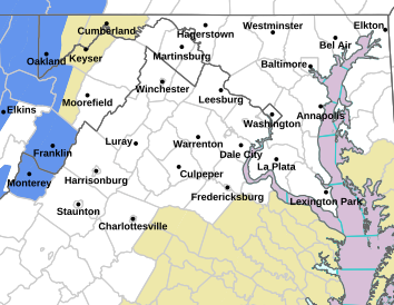
The National Weather Service has cancelled Severe Thunderstorm
Watch 190 for the following areas

In Maryland this cancels 8 counties

In central Maryland

Howard Montgomery

In north central Maryland

Carroll Frederick Washington

In northern Maryland

Baltimore Harford

In western Maryland

Allegany

In Virginia this cancels 14 counties

In central Virginia

Albemarle Greene Nelson

In northern Virginia

Loudoun

In northwest Virginia

Clarke Frederick Madison
Page Rappahannock Shenandoah
Warren

In western Virginia

Augusta Highland Rockingham

In West Virginia this cancels 8 counties

In northeast West Virginia

Berkeley Grant Hampshire
Hardy Jefferson Mineral
Morgan Pendleton

In Maryland this cancels 1 independent city

In northern Maryland

Baltimore City

In Virginia this cancels 5 independent cities

In central Virginia

Charlottesville

In northwest Virginia

City of Harrisonburg City of Winchester

In western Virginia

City of Staunton City of Waynesboro

This includes the cities of…Aberdeen…Bayard…Bel Air…
Berryville…Charles Town…Charlottesville…Columbia…
Cumberland…Edgewood…Elk Garden…Fallston…Fort Ashby…
Franklin…Frederick…Front Royal…Gaithersburg…Greenfield…
Hagerstown…Harrisonburg…Havre de Grace…Joppatowne…
Keyser…Leesburg…Luray…Madison…Martinsburg…Monterey…
Moorefield…Mount Storm…Paw Paw…Petersburg…Romney…
Stanardsville…Staunton…Sterling…Strasburg…Towson…
Washington…Waynesboro…Westminster…Winchester and Woodstock.

SEVERE THUNDERSTORM WATCH NUMBER 281
Scroll for city / county outlines

URGENT – IMMEDIATE BROADCAST REQUESTED
SEVERE THUNDERSTORM WATCH NUMBER 281
NWS STORM PREDICTION CENTER NORMAN OK
325 PM EDT WED JUN 11 2014

THE NWS STORM PREDICTION CENTER HAS ISSUED A

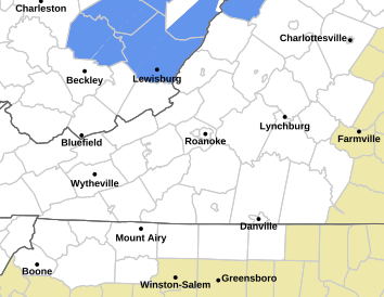
* SEVERE THUNDERSTORM WATCH FOR PORTIONS OF
SOUTHEAST MARYLAND
NORTHERN NORTH CAROLINA
VIRGINIA
FAR EASTERN WEST VIRGINIA
COASTAL WATERS

* EFFECTIVE THIS WEDNESDAY AFTERNOON AND EVENING FROM 325 PM
UNTIL 1000 PM EDT.

* PRIMARY THREATS INCLUDE…
SCATTERED DAMAGING WIND GUSTS TO 70 MPH POSSIBLE
ISOLATED VERY LARGE HAIL EVENTS TO 2 INCHES IN DIAMETER POSSIBLE

THE SEVERE THUNDERSTORM WATCH AREA IS APPROXIMATELY ALONG AND 75
STATUTE MILES NORTH AND SOUTH OF A LINE FROM 20 MILES WEST
NORTHWEST OF ROANOKE VIRGINIA TO 55 MILES EAST SOUTHEAST OF
RICHMOND VIRGINIA. FOR A COMPLETE DEPICTION OF THE WATCH SEE THE
ASSOCIATED WATCH OUTLINE UPDATE (WOUS64 KWNS WOU1).

PRECAUTIONARY/PREPAREDNESS ACTIONS…

REMEMBER…A SEVERE THUNDERSTORM WATCH MEANS CONDITIONS ARE
FAVORABLE FOR SEVERE THUNDERSTORMS IN AND CLOSE TO THE WATCH
AREA. PERSONS IN THESE AREAS SHOULD BE ON THE LOOKOUT FOR
THREATENING WEATHER CONDITIONS AND LISTEN FOR LATER STATEMENTS
AND POSSIBLE WARNINGS. SEVERE THUNDERSTORMS CAN AND OCCASIONALLY
DO PRODUCE TORNADOES.

&&

OTHER WATCH INFORMATION…CONTINUE…WW 279…WW 280…

DISCUSSION…SCATTERED MULTICELL/SOME SUPERCELL STORMS WILL CONTINUE
TO INCREASE WITHIN AN ENVIRONMENT CHARACTERIZED BY MODERATE TO
STRONG INSTABILITY AND MODEST VERTICAL SHEAR. DAMAGING WINDS AND
BOUTS OF LARGE HAIL ARE THE PRIMARY CONCERN.

AVIATION…A FEW SEVERE THUNDERSTORMS WITH HAIL SURFACE AND ALOFT
TO 2 INCHES. EXTREME TURBULENCE AND SURFACE WIND GUSTS TO 60
KNOTS. A FEW CUMULONIMBI WITH MAXIMUM TOPS TO 500. MEAN STORM
MOTION VECTOR 23020.

SEVERE THUNDERSTORM WATCH OUTLINE UPDATE FOR WS 281
NWS STORM PREDICTION CENTER NORMAN OK
325 PM EDT WED JUN 11 2014

SEVERE THUNDERSTORM WATCH 281 IS IN EFFECT UNTIL 1000 PM EDT
FOR THE FOLLOWING LOCATIONS

VA
. VIRGINIA COUNTIES INCLUDED ARE

ALBEMARLE ALLEGHANY AMELIA
AMHERST APPOMATTOX AUGUSTA
BATH BEDFORD BLAND
BOTETOURT BRUNSWICK BUCKINGHAM
CAMPBELL CAROLINE CARROLL
CHARLES CITY CHARLOTTE CHESTERFIELD
CRAIG CULPEPER CUMBERLAND
DINWIDDIE ESSEX FLOYD
FLUVANNA FRANKLIN GILES
GLOUCESTER GOOCHLAND GRAYSON
GREENE GREENSVILLE HALIFAX
HANOVER HENRICO HENRY
HIGHLAND ISLE OF WIGHT JAMES CITY
KING AND QUEEN KING GEORGE KING WILLIAM
LANCASTER LOUISA LUNENBURG
MADISON MATHEWS MECKLENBURG
MIDDLESEX MONTGOMERY NELSON
NEW KENT NORTHUMBERLAND NOTTOWAY
ORANGE PAGE PATRICK
PITTSYLVANIA POWHATAN PRINCE EDWARD
PRINCE GEORGE PULASKI RAPPAHANNOCK
RICHMOND ROANOKE ROCKBRIDGE
ROCKINGHAM SOUTHAMPTON SPOTSYLVANIA
STAFFORD SURRY SUSSEX
WESTMORELAND WYTHE YORK

VIRGINIA INDEPENDENT CITIES INCLUDED ARE

BUENA VISTA CHARLOTTESVILLE CHESAPEAKE
COLONIAL HEIGHTS COVINGTON DANVILLE
EMPORIA FRANKLIN FREDERICKSBURG
GALAX HAMPTON HARRISONBURG
HOPEWELL LEXINGTON LYNCHBURG
MARTINSVILLE NEWPORT NEWS NORFOLK
PETERSBURG POQUOSON RADFORD
RICHMOND ROANOKE SALEM
STAUNTON SUFFOLK WAYNESBORO
WILLIAMSBURG
$$

CBS-19 Chief Meteorologist Grabs Very Moving Photo On Parkway

0
Photo Courtesy of Travis Koshko : Chief Meteorologist Travis Koshko of CBS-19 in Charlottesville ran upon this remarkable photo opportunity last Friday evening while traveling the Blue Ridge Parkway. A group of individuals came to Ravens Roost Overlook to pay tribute to the soldiers who died seventy years ago on D-Day.

Ravens Roost
Blue Ridge Parkway

Our pal Chief Meteorologist Travis Koshko of CBS-19 in Charlottesville grabbed a very touching and moving photo not long ago when traveling the Blue Ridge Parkway. “They saluted while holding an American flag and played Taps while facing the sunset. It was a pretty neat moment to witness, and I’m glad I was able to capture it,” Travis told his Facebook followers.

We’re glad you captured it too Travis and allowed us to share it!

Tommy’s Weather Back On Daily Routine & Where’s Our Weather Station?

0


After a few days away for a move, Tommy’s back with his regular daily weather. Specifically for the Central Virginia Blue Ridge Area.

Nelson County, VA
After a few days away to do a move, we’re back with our daily weather!Thanks for hanging in there during the wait.

Many of you have asked about our BRL Weather Station that’s normally online in Greenfield of Nelson County. When we moved our offices that station has temporarily gone offline. We expect to have it back online on or before July 1st. We are working on an exciting partnership for that station that will keep it in Greenfield! More on that in the days to come.

In the meantime we encourage you to visit Idlebrink Farm. They were just down the road from where out office used to be in Greenfield. They are great friends to BRL! There station is just below:

Find more about Weather in Greenfield, VA
Click for weather forecast

You can also always visit our mountain weather station that’s a partnership between BRL and The Nature Foundation At Wintergreen.
Visit that one below:

Find more about Weather in 3500 Feet-Wintergreen Mtn, VA
Click for weather forecast

More details soon!

Nelson Residents Express Pipeline Concerns At Meeting Via CBS-19

0
Photo Courtesy of CBS-19 : Nelson Residents Packed  a meeting Sunday evening regarding a proposed pipeline through the county.
Photo Courtesy of CBS-19 : Nelson Residents packed a meeting Sunday evening regarding a proposed pipeline through the county.

Lovingston
Nelson County, VA

We are in relocation mode, but our media partners over at CBS19 have full coverage here.

And our Paul Purpura was there as well. More updates soon.

Citizens Concerned About Southern Reliability Project (Dominion Transmission) Meet This Weekend

0

Via Nelson County, VA Administrator's office: A Map showing the proposed pipeline that would run from West Virginia to North Carolina.
Via Nelson County, VA Administrator’s office: A Map showing the proposed pipeline that would run from West Virginia to North Carolina. Click photo to enlarge.
A more detailed map provided by the Nelson County, VA Administrator's office. Note disclaimer upper right.
A more detailed map provided by the Nelson County, VA Administrator’s office. Note disclaimer upper right. Click photo to enlarge.

Tornado Watch For Counties Amherst South / West Until 3AM – !Canceled!

0

As of 1:50 AM EDT June 5, 2014:

The National Weather Service has cancelled Tornado Watch 222 for
the following areas

In North Carolina this cancels 6 counties

In north central North Carolina

Surry

In northwest North Carolina

Alleghany NC Ashe Watauga
Wilkes Yadkin

In Virginia this cancels 20 counties

In central Virginia

Amherst

In south central Virginia

Bedford

In southwest Virginia

Bland Carroll Craig
Floyd Giles Grayson
Montgomery Patrick Pulaski
Smyth Tazewell Wythe

In west central Virginia

Alleghany VA Bath Botetourt
Franklin Roanoke Rockbridge

In West Virginia this cancels 4 counties

In southeast West Virginia

Greenbrier Mercer Monroe
Summers

In Virginia this cancels 7 independent cities

In southwest Virginia

Galax Radford

In west central Virginia

Buena Vista Covington Lexington
Roanoke Salem

URGENT – IMMEDIATE BROADCAST REQUESTED
TORNADO WATCH NUMBER 222
NWS STORM PREDICTION CENTER NORMAN OK
800 PM EDT WED JUN 4 2014

THE NWS STORM PREDICTION CENTER HAS ISSUED A

* TORNADO WATCH FOR PORTIONS OF
WESTERN NORTH CAROLINA
EASTERN TENNESSEE
WEST CENTRAL AND SOUTHWEST VIRGINIA
SOUTHERN WEST VIRGINIA

* EFFECTIVE THIS WEDNESDAY NIGHT AND THURSDAY MORNING FROM 800 PM
UNTIL 300 AM EDT.

* PRIMARY THREATS INCLUDE…
A COUPLE TORNADOES POSSIBLE
SCATTERED LARGE HAIL EVENTS TO 1.5 INCHES IN DIAMETER POSSIBLE
ISOLATED DAMAGING WIND GUSTS TO 70 MPH POSSIBLE

THE TORNADO WATCH AREA IS APPROXIMATELY ALONG AND 75 STATUTE
MILES EAST AND WEST OF A LINE FROM 30 MILES NORTHEAST OF WHITE
SULPHUR SPRINGS WEST VIRGINIA TO 25 MILES SOUTHWEST OF HOT
SPRINGS NORTH CAROLINA. FOR A COMPLETE DEPICTION OF THE WATCH
SEE THE ASSOCIATED WATCH OUTLINE UPDATE (WOUS64 KWNS WOU2).

PRECAUTIONARY/PREPAREDNESS ACTIONS…

REMEMBER…A TORNADO WATCH MEANS CONDITIONS ARE FAVORABLE FOR
TORNADOES AND SEVERE THUNDERSTORMS IN AND CLOSE TO THE WATCH
AREA. PERSONS IN THESE AREAS SHOULD BE ON THE LOOKOUT FOR
THREATENING WEATHER CONDITIONS AND LISTEN FOR LATER STATEMENTS
AND POSSIBLE WARNINGS.

&&

OTHER WATCH INFORMATION…CONTINUE…WW 218…WW 219…WW
220…WW 221…

DISCUSSION…CLUSTERS OF SEMI-DISCRETE STORMS/SUPERCELLS EXPECTED TO
PERSIST ALONG THE W SLOPES OF THE SRN APPALACHIANS THROUGH LATE
EVE…WITH ADDITIONAL STORMS POSSIBLY MOVING/DEVELOPING EWD INTO WRN
AND SW VA AS MID-LVL SPEED MAX AND ASSOCIATED UVV FIELD OVERSPREAD
MOIST/CONFLUENT LOW–LVL FLOW.

AVIATION…TORNADOES AND A FEW SEVERE THUNDERSTORMS WITH HAIL
SURFACE AND ALOFT TO 1.5 INCHES. EXTREME TURBULENCE AND SURFACE
WIND GUSTS TO 60 KNOTS. A FEW CUMULONIMBI WITH MAXIMUM TOPS TO
500. MEAN STORM MOTION VECTOR 30030.

TORNADO WATCH OUTLINE UPDATE FOR WT 222
NWS STORM PREDICTION CENTER NORMAN OK
800 PM EDT WED JUN 4 2014

TORNADO WATCH 222 IS IN EFFECT UNTIL 300 AM EDT FOR THE
FOLLOWING LOCATIONS

VAC005-009-017-019-021-023-035-045-063-067-071-077-105-121-141-
155-161-163-167-169-173-185-191-195-197-520-530-580-640-678-720-
750-770-775-050700-
/O.NEW.KWNS.TO.A.0222.140605T0000Z-140605T0700Z/

VA
. VIRGINIA COUNTIES INCLUDED ARE

ALLEGHANY AMHERST BATH
BEDFORD BLAND BOTETOURT
CARROLL CRAIG FLOYD
FRANKLIN GILES GRAYSON
LEE MONTGOMERY PATRICK
PULASKI ROANOKE ROCKBRIDGE
RUSSELL SCOTT SMYTH
TAZEWELL WASHINGTON WISE
WYTHE

VIRGINIA INDEPENDENT CITIES INCLUDED ARE

BRISTOL BUENA VISTA COVINGTON
GALAX LEXINGTON NORTON
RADFORD ROANOKE SALEM

Last Reminder Of BB&T Bank In Afton To Be Removed : ATM Taken Out This Week

0
Photo Courtesy Of Todd Rath : After years & years as a landmark on Route 151 In Afton of Northern Nelson County, the BB & T ATM will be removed this week. The bank itself closed months ago and the building is being sold.

Afton
Nelson County, VA

After years of presence in the Afton location, BB&T bank closed some months ago. The final reminder of that will go away this week after the ATM will go away. “I have been trying to work with BBT to leave the ATM on the property after our (real estate) closing Tuesday. They have decided its not worth it for their business,” Nelson businessman Todd Rath tell us. Todd and business partners are buying the old bank building for commercial interests.

“I tried, I know a ton of people use it and depend on it,” Todd added.

According to Todd, the ATM will be removed on Monday – June 2nd.

RIP Pat : Driving Force Behind Virginia Distillery Company In Lovingston Passes Away : Via VDC

0
Photos Courtesy of Virginia Distillery Company. Our thoughts are with everyone at VDC. We recently learned of the passing of Pat Jones-McCray. Pat was described as a driving force at VDC.

Lovingston
Nelson County, VA

Sadly we report the passing of a person that became a long time friend to BRL. Pat Jones-McCray died this past weekend.

Below is the pasted text from the VDC Facebook page. RIP Pat, we will miss you.

“Friends, our own Pat Jones-McCray passed away this past weekend. This is a difficult and shocking announcement to make because for so long, Pat has been a major driving force behind VDC. She had taken a well-deserved step back from the day-to-day operations of the company, but was still very involved in all of our lives.

For the first few years, she populated this and our other social media spaces. At first I was struck by how difficult it was to find a picture of her, but now it makes sense. She was the one behind the camera letting you all in on our world. She was the one behind the scenes pushing and guiding us in the right direction.

She is a huge reason we are here today, on the cusp of finishing this project, and it pains me to think that she will not see the result of so much of her own hard work. We ask that you keep her husband John and her family in your thoughts and prayers.

We will miss her and her tenacious spirit greatly.”

You can read more on the history of Pat and VDC by click here in our archives.

Dominion Proposes Gas Pipeline From W.Va. to NC : Via The State Journal In WV

0

Page 1 of the pipeline letter many area Nelson residents have been receiving via certified mail. Click on image to enlarge.
Page 2 of the pipeline letter many area Nelson residents have been receiving via certified mail. Click on image to enlarge.

A Few Hundred People Left Without Power After Storms Move Across Area Tuesday Evening

0

Click here for the latest updates to the power outage map from CVEC.

- Advertisement -