Nelson County, Virginia
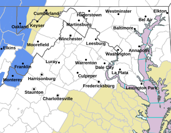
As expected, snow began falling late in the day across the Blue Ridge Mountains of Central Virginia. Winter Weather Advisories have been posted through Friday morning most of the area. In the higher elevations snow began sticking by 4PM.
The snow has arrived at SHD! Hopefully this will be the last time we see the white stuff this season. What do you think? Love the snow or hate it? ❄️❄️
The Brew Ridge Trail, Virginia’s Original Beer Destination, is coming together to celebrate award-winning local craft beer in Central Virginia with the first Brew Ridge Trail Week from March 14 – 19, 2016. Brewers from Blue Mountain Brewery, Blue Mountain Barrel House, Devils Backbone, South Street, Starr Hill and Wild Wolf collaborated on a Belgian-Style Quadrupel Ale to be released that week in each member’s tap room. A contest was held to name the collaboration beer and the name “Too Many Cooks” was selected.
“The latest Brew Ridge Trail collaboration beer is the first of this series created at South Street Brewery, and it completes the cycle of all six breweries on the trail having hosted a collaboration brew,” said Blue Mountain Brewery Founder and Brewmaster, Taylor Smack. “For such a momentous event, we chose one of the biggest beer styles out there, the Belgian Quad, which is also a fun beer to tackle because it lends itself to the addition of so many different ingredients.”
Brewed at South Street Brewery on January 20, each brewer provided different ingredients that went into the recipe for “Too Many Cooks.” Local honey, Belgian “candi” sugar made from sugar beets, dark German malts, Slovenian hops, star anise, orange peel and more were all part of this beer that features yeast from the Rochefort Trappist monastery brewery. “Too Many Cooks” promises to be a heady ale with deep, naturally spicy Belgian flavors, topping out at 12.55% alcohol by volume.
Special events are scheduled at each of the breweries during Brew Ridge Trail Week, including tap takeovers featuring the collaboration beer at select retail accounts around Virginia, as well as happenings at each of the trail members’ brewery locations. Brew Ridge Trail Week kicks off with an Industry Night and “Meet the Brewers” event at Starr Hill on March 15. The “Too Many Cooks” collaboration beer will be officially released at South Street on March 16.
Other highlights during the week include: Devils Backbone Mug Club event on March 14; Locals Night at Blue Mountain on March 16; Saint Patrick’s Day Parties at Blue Mountain Brewery and Wild Wolf on March 17; Whoa Nelly Launch Party at Wild Wolf and Friday Cheers at the Blue Mountain Barrel House on March 18; Reilly’s 5k Run at Devils Backbone and St. Patty’s Day event at Starr Hill on March 19. For a full list of events, visit www.BrewRidgeTrail.com/Events
Click on flier above to enlarge and read about the March events.
Via NWS : Various winter weather advisories go into effect Thursday evening until Friday morning for most of Central Virginia.
EXPIRED – EXPIRED – EXPIRED
URGENT – WINTER WEATHER MESSAGE
NATIONAL WEATHER SERVICE BALTIMORE MD/WASHINGTON DC
208 PM EST THU MAR 3 2016
VAZ025>027-029-036>040-050-051-503-504-507-508-WVZ055-502-505-506-
040315-
/O.CON.KLWX.WW.Y.0009.160303T2300Z-160304T1500Z/
AUGUSTA-ROCKINGHAM-SHENANDOAH-PAGE-NELSON-ALBEMARLE-GREENE-
MADISON-RAPPAHANNOCK-ORANGE-CULPEPER-WESTERN HIGHLAND-
EASTERN HIGHLAND-NORTHERN VA BLUE RIDGE-CENTRAL VA BLUE RIDGE-
HARDY-EASTERN GRANT-WESTERN PENDLETON-EASTERN PENDLETON-
208 PM EST THU MAR 3 2016
…WINTER WEATHER ADVISORY REMAINS IN EFFECT FROM 6 PM THIS
EVENING TO 10 AM EST FRIDAY…
* PRECIPITATION TYPE…SNOW
* ACCUMULATIONS…ONE TO THREE INCHES…UP TO FOUR INCHES AT
HIGHER ELEVATIONS.
* TIMING…PRECIPITATION WILL BEGIN AS A RAIN-SNOW MIX LATE THIS
AFTERNOON…TRANSITIONING TO ALL SNOW THIS EVENING. SNOW IS
EXPECTED THROUGH THE NIGHT…TAPERING OFF FRIDAY MORNING.
* IMPACTS…THE SNOW WILL CAUSE SLIPPERY ROADS…RESULTING IN
HAZARDOUS TRAVEL CONDITIONS.
* WINDS…EAST 5 TO 10 MPH.
* TEMPERATURES…IN THE LOWER 30S.
PRECAUTIONARY/PREPAREDNESS ACTIONS…
A WINTER WEATHER ADVISORY FOR SNOW MEANS THAT PERIODS OF SNOW
WILL CAUSE PRIMARILY TRAVEL DIFFICULTIES. BE PREPARED FOR SNOW
COVERED ROADS AND LIMITED VISIBILITIES…AND USE CAUTION WHILE
DRIVING.
&&
$$
URGENT – WINTER WEATHER MESSAGE
NATIONAL WEATHER SERVICE BLACKSBURG VA
332 PM EST THU MAR 3 2016
…SNOW EXPECTED THIS EVENING AND OVERNIGHT…
.A FAST MOVING AREA OF LOW PRESSURE WILL TRACK FROM THE
MISSISSIPPI VALLEY THIS EVENING TO THE COAST OF NORTH CAROLINA
FRIDAY MORNING. THIS WILL BRING SNOW TO THE REGION WITH THE
HEAVIEST AMOUNTS WEST OF THE BLUE RIDGE AND NORTH OF ROUTE 460.
VAZ032>034-045-046-059-040300-
/O.CAN.KRNK.WS.W.0004.160303T2300Z-160304T1500Z/
/O.EXA.KRNK.WW.Y.0010.160303T2300Z-160304T1500Z/
PATRICK-FRANKLIN-BEDFORD-CAMPBELL-APPOMATTOX-CHARLOTTE-
INCLUDING THE CITIES OF…STUART…ROCKY MOUNT…BEDFORD…
LYNCHBURG…APPOMATTOX…KEYSVILLE
332 PM EST THU MAR 3 2016
…WINTER WEATHER ADVISORY IN EFFECT UNTIL 10 AM EST FRIDAY…
…WINTER STORM WARNING IS CANCELLED…
THE NATIONAL WEATHER SERVICE IN BLACKSBURG HAS ISSUED A WINTER
WEATHER ADVISORY FOR SNOW…WHICH IS IN EFFECT UNTIL 10 AM EST
FRIDAY. THE WINTER STORM WARNING HAS BEEN DOWNGRADED.
* LOCATIONS…THE FOOTHILLS AND PIEDMONT OF SOUTHWEST VIRGINIA.
* HAZARD TYPES…SNOW.
* ACCUMULATIONS…SNOW ACCUMULATION OF 1 TO 3 INCHES.
* TIMING…THE MOST LIKELY TIME FOR ACCUMULATING SNOW WILL BE
FROM AROUND MIDNIGHT THROUGH 6AM.
* IMPACTS…TRAVEL DIFFICULTIES DUE TO SNOW ON ROADWAYS. THE
MORNING COMMUTE WILL BE IMPACTED.
* WINDS…NORTHEAST 5 MPH OR LESS.
* TEMPERATURES…LOWS TONIGHT IN THE LOWER 30S.
PRECAUTIONARY/PREPAREDNESS ACTIONS…
A WINTER WEATHER ADVISORY FOR SNOW MEANS THAT PERIODS OF SNOW
WILL CAUSE PRIMARILY TRAVEL DIFFICULTIES. BE PREPARED FOR SNOW
COVERED ROADS AND LIMITED VISIBILITIES…AND USE CAUTION WHILE
DRIVING.
&&
$$
URGENT – WINTER WEATHER MESSAGE
NATIONAL WEATHER SERVICE BLACKSBURG VA
332 PM EST THU MAR 3 2016
…SNOW EXPECTED THIS EVENING AND OVERNIGHT…
.A FAST MOVING AREA OF LOW PRESSURE WILL TRACK FROM THE
MISSISSIPPI VALLEY THIS EVENING TO THE COAST OF NORTH CAROLINA
FRIDAY MORNING. THIS WILL BRING SNOW TO THE REGION WITH THE
HEAVIEST AMOUNTS WEST OF THE BLUE RIDGE AND NORTH OF ROUTE 460.
NCZ001>004-018-019-VAZ007-009>020-022>024-035-043-044-047-058-
WVZ042>044-507-508-040300-
/O.CON.KRNK.WW.Y.0010.160303T2300Z-160304T1500Z/
ASHE-ALLEGHANY NC-SURRY-STOKES-WATAUGA-WILKES-TAZEWELL-SMYTH-
BLAND-GILES-WYTHE-PULASKI-MONTGOMERY-GRAYSON-CARROLL-FLOYD-CRAIG-
ALLEGHANY VA-BATH-ROANOKE-BOTETOURT-ROCKBRIDGE-AMHERST-HENRY-
PITTSYLVANIA-BUCKINGHAM-HALIFAX-MERCER-SUMMERS-MONROE-
EASTERN GREENBRIER-WESTERN GREENBRIER-
INCLUDING THE CITIES OF…WEST JEFFERSON…SPARTA…DOBSON…
DANBURY…BOONE…WILKESBORO…TAZEWELL…MARION…BLAND…
PEARISBURG…WYTHEVILLE…RADFORD…PULASKI…BLACKSBURG…
INDEPENDENCE…WHITETOP…TROUTDALE…VOLNEY…GALAX…FLOYD…
NEW CASTLE…CLIFTON FORGE…COVINGTON…HOT SPRINGS…ROANOKE…
SALEM…FINCASTLE…LEXINGTON…BUENA VISTA…AMHERST…
MARTINSVILLE…DANVILLE…SOUTH BOSTON…BLUEFIELD…HINTON…
HIX…UNION
332 PM EST THU MAR 3 2016
…WINTER WEATHER ADVISORY REMAINS IN EFFECT UNTIL 10 AM EST
FRIDAY…
* LOCATIONS…SOUTHEAST WEST VIRGINIA…SOUTHEAST WEST VIRGINIA AND
THE NORTHWEST NORTH CAROLINA MOUNTAINS AND FOOTHILLS.
* HAZARD TYPES…SNOW.
* ACCUMULATIONS…SNOW ACCUMULATION OF 1 TO 3 INCHES…WITH
LOCALLY HIGH AMOUNTS IN THE HIGHER ELEVATIONS OF WESTERN
GREENBRIER COUNTY WEST VIRGINIA…AND FROM GRAYSON COUNTY
VIRGINIA TO WATAUGA COUNTY NORTH CAROLINA.
* TIMING…THE MOST LIKELY TIME FOR ACCUMULATING SNOW WILL BE FROM
AROUND 7PM THROUGH 4AM.
* IMPACTS…TRAVEL DIFFICULTIES DUE TO SNOW ON ROADWAYS. THIS
EVENINGS COMMUTE WILL BE IMPACTED ALONG AND WEST OF I-81.
* WINDS…NORTHEAST 5 TO 10 MPH WITH GUSTS UP TO 20 MPH.
* TEMPERATURES…LOWS IN THE UPPER 20S TO THE LOWER 30S.
PRECAUTIONARY/PREPAREDNESS ACTIONS…
A WINTER WEATHER ADVISORY FOR SNOW MEANS THAT PERIODS OF SNOW
WILL CAUSE PRIMARILY TRAVEL DIFFICULTIES. BE PREPARED FOR SNOW
COVERED ROADS AND LIMITED VISIBILITIES…AND USE CAUTION WHILE
DRIVING.
Image courtesy of pivotalweather.com : One of the weather models that shows the potential for some snow by Friday morning around 7AM. As of late Wednesday models indicate anywhere from an inch or so to 3-4+ inches is possible across portions of Virginia. This and a small late weekend burst of will most likely be the last of significant snow for the season as much warmer weather takes a seat next week.
Central Virginia Blue Ridge
In what’s probably the last of the snow for the 2015-2016 season may begin falling late Thursday evening into the morning hours Friday. There’s still a lot our there to be determined on exactly where this system will put the most snowfall, but as of late Wednesday, the potential is there for enough snow in some locations that might disrupt travel early Friday morning. At least initially.
Here is the latest on accumulating snow Thursday evening into Friday morning that could impact your Friday AM commute!
Regardless, it won’t be around long as temps will rise into the mid 40’s on Friday. There’s another chance for some light snow late in the weekend, then temps rise to around 70° several days next week. A major pattern change is coming and it doesn’t look like conditions will be favorable for much, if any, more snow this season.
Spring officially starts on March 20th at 12:30 AM.
Via NWS : A WIND ADVISORY is in effect for many areas along and near the Blue Ridge Parkway in Central Virginia from Tuesday night until Wednesday afternoon.
URGENT – WEATHER MESSAGE
NATIONAL WEATHER SERVICE BALTIMORE MD/WASHINGTON DC
331 AM EST TUE MAR 1 2016
MDZ501-VAZ025-026-503-504-507-508-WVZ055-501>503-505-506-011645-
/O.NEW.KLWX.WI.Y.0007.160302T0200Z-160302T1700Z/
EXTREME WESTERN ALLEGANY-AUGUSTA-ROCKINGHAM-WESTERN HIGHLAND-
EASTERN HIGHLAND-NORTHERN VA BLUE RIDGE-CENTRAL VA BLUE RIDGE-
HARDY-WESTERN GRANT-EASTERN GRANT-WESTERN MINERAL-
WESTERN PENDLETON-EASTERN PENDLETON-
INCLUDING THE CITIES OF…FROSTBURG…STAUNTON…WAYNESBORO…
STUARTS DRAFT…HARRISONBURG…HIGHTOWN…MONTEREY…
BIG MEADOWS…WINTERGREEN…MOOREFIELD…BAYARD…MOUNT STORM…
PETERSBURG…ELK GARDEN…CIRCLEVILLE…FRANKLIN
331 AM EST TUE MAR 1 2016
…WIND ADVISORY IN EFFECT FROM 9 PM THIS EVENING TO NOON EST
WEDNESDAY…
THE NATIONAL WEATHER SERVICE IN BALTIMORE MD/WASHINGTON HAS
ISSUED A WIND ADVISORY…WHICH IS IN EFFECT FROM 9 PM THIS
EVENING TO NOON EST WEDNESDAY.
* TIMING…LATE THIS EVENING THROUGH WEDNESDAY MORNING. THE
STRONGEST WINDS WILL BE BETWEEN MIDNIGHT AND 10 AM WEDNESDAY.
* WINDS…SOUTHWEST 20 TO 35 MPH WITH GUSTS AROUND 50
MPH…BECOMING NORTHWEST OVERNIGHT INTO WEDNESDAY.
* IMPACTS…SCATTERED TREE AND POWER LINE DAMAGE. DIFFICULTY
DRIVING HIGH PROFILE VEHICLES.
PRECAUTIONARY/PREPAREDNESS ACTIONS…
A WIND ADVISORY MEANS THAT WIND GUSTS OF 45 TO 55 MPH ARE
EXPECTED. SECURE OUTDOOR FURNITURE AND TAKE CARE DRIVING HIGH
PROFILE VEHICLES.
&&
$$
URGENT – WEATHER MESSAGE
NATIONAL WEATHER SERVICE BLACKSBURG VA
250 PM EST TUE MAR 1 2016
…STRONG WESTERLY WINDS TONIGHT INTO WEDNESDAY…
.A COLD FRONT WILL CROSS THE REGION TONIGHT PRODUCING SHOWERS AND
A FEW THUNDERSTORMS. WINDS WILL INCREASE OUT OF THE WEST BEHIND
THE FRONT…AND WILL BE ESPECIALLY GUSTY ALONG THE RIDGE CRESTS.
STRONG WIND GUSTS WILL BE POSSIBLE UNTIL NOON WEDNESDAY BEFORE
DIMINISHING.
NCZ002-VAZ007-009>014-016>020-022>024-WVZ042>044-507-508-020400-
/O.EXT.KRNK.WI.Y.0006.160302T0000Z-160302T1700Z/
ALLEGHANY NC-TAZEWELL-SMYTH-BLAND-GILES-WYTHE-PULASKI-MONTGOMERY-
CARROLL-FLOYD-CRAIG-ALLEGHANY VA-BATH-ROANOKE-BOTETOURT-
ROCKBRIDGE-MERCER-SUMMERS-MONROE-EASTERN GREENBRIER-
WESTERN GREENBRIER-
INCLUDING THE CITIES OF…SPARTA…TAZEWELL…MARION…BLAND…
PEARISBURG…WYTHEVILLE…RADFORD…PULASKI…BLACKSBURG…
GALAX…FLOYD…NEW CASTLE…CLIFTON FORGE…COVINGTON…
HOT SPRINGS…ROANOKE…SALEM…FINCASTLE…LEXINGTON…
BUENA VISTA…BLUEFIELD…FLAT TOP…HINTON…HIX…UNION…
LEWISBURG…WHITE SULPHUR SPRINGS…ALDERSON…QUINWOOD…DUO…
RAINELLE
250 PM EST TUE MAR 1 2016
…WIND ADVISORY NOW IN EFFECT FROM 7 PM THIS EVENING TO NOON EST
WEDNESDAY…
* LOCATIONS…PART OF THE HIGH COUNTRY OF NORTH CAROLINA…HIGHLANDS
OF VIRGINIA AND WEST VIRGINIA…INCLUDING THE GREENBRIER…NEW
RIVER…ROANOKE AND SOUTHERN SHENANDOAH VALLEYS.
* HAZARDS…STRONG GUSTY WINDS.
* WINDS…WEST 20 TO 30 MPH WITH GUSTS UP TO 50 MPH. GUSTS NEAR 55
MPH ARE POSSIBLE FOR ELEVATIONS ABOVE 3500 FEET.
* TIMING…BEGINNING WITH THE FRONTAL PASSAGE THIS EVENING…
WITH THE STRONGEST GUSTS OCCURRING DURING THE OVERNIGHT HOURS.
* IMPACTS…STRONG WINDS MAY BLOW DOWN TREES AND POWER LINES.
CROSS WINDS ALONG INTERSTATE 77 AND 81 WILL MAKE DRIVING A
CHALLENGE…ESPECIALLY FOR HIGH PROFILE VEHICLES.
PRECAUTIONARY/PREPAREDNESS ACTIONS…
A WIND ADVISORY MEANS THAT WINDS OF 35 MPH ARE EXPECTED. WINDS
THIS STRONG CAN MAKE DRIVING DIFFICULT…ESPECIALLY FOR HIGH
PROFILE VEHICLES. USE EXTRA CAUTION.
Nellysford
Nelson County, Virginia
Thursday night was the launch party, but next weekend is the main event! The Be Bold Weekend At Wintergreen will be held from March 4tth thru the 6th. It’s the inaugural event. Thursday night’s launch included the screening of Warren Miller’s most recent ski and snowboard documentary, Chasing Shadows, along with a ski/snowboard raffle and pre-registration for the exciting Wintergreen Tread & Trail Mountain Bike Race & Trail Run Series sponsored by Bold Rock Hard Cider coming this Summer and Fall to Wintergreen Resort. (more on that series in the near future)
Bold Rock says, “Be Bold Weekend is intended to encourage an active lifestyle, pushing your limits and breaking down barriers, no matter the skill level. Be Bold Weekend will feature multiple Bold Rock related activities including Steal The Pint Night’s at The Edge Restaurant, the annual Double Cross Race, daily parties on the Blue Ridge Terrace, and great giveaways throughout!”
Scroll down below our Facebook Album for a complete outline of the weekend’s activities.
Folks got together this past Thursday evening for the launch party of the Be Bold Weekend At Wintergreen that takes…
Be Bold Weekend Day 1
Friday, March 4
The Edge Restaurant at Wintergreen Resort – Wintergreen, VA
The weekend kicks off with a Steal The Pint Night starting at 7 PM at The Edge Restaurant at Wintergreen Resort! Hit the slopes in the afternoon and then unwind with 4 different Bold Rock Hard Ciders on tap, live music, branded merchandise giveaways and of course a complimentary commemorative pint glass.
Be Bold Weekend Day 2
Saturday, March 5
Blue Ridge Terrace/The Edge Restaurant at Wintergreen Resort – Wintergreen, VA
Day 2 of the Be Bold Weekend is all about the Blue Ridge Terrace and annual Freestyle Double Cross Races. Starting at 10 AM, compete in the exciting Freestyle Double Cross Races, a speed trial broken up into age groups and ski/snowboard categories. Then join us on the Blue Ridge Terrace for a day long party featuring cold cider, hot chocolate, burgers and hot dogs. Double Cross winner’s podium participants to receive prize packages and bragging rights across the mountain and beyond. The evening features another Steal The Pint Night at The Edge Restaurant starting at 7 PM with more live music, MoxBox Photo Booth and 4 different Bold Rock Hard Ciders on tap!
Be Bold Weekend Day 3
Sunday, March 6
Blue Ridge Terrace at Wintergreen Resort – Wintergreen, VA
Day 3 of the Be Bold Weekend at Wintergreen Resort features a full day of slope-side partying from 11 AM – 6 PM on the Blue Ridge Terrace with merchandise raffles throughout the afternoon. Carve up the slopes and then swing on by for cold Bold Rock, discount vouchers for our Nellysford Cider Barn and to chat it up with Bold Rock and Wintergreen brand ambassadors.
Evergreen
Appomattox County, Virginia
Images continue to come in from the destruction of Wednesday’s killer tornadoes across Virginia. Central Virginia Aerial Solutions provided the above footage to WSET – ABC-13 in Lynchburg of the damage in the Evergreen community of Appomattox County. One man was killed there from the tornado strike.
The footage shows the incredible destructive strength of the twister.
Photo courtesy of Central Virginia Electric Coop : A downed transformer in the foreground where a killer tornado hit in the Evergreen area of Appomattox County on Wednesday – February 24, 2016.
Appomattox County, Virginia As we first reported yesterday, killer tornadoes spread out across Virginia on Wednesday afternoon killing at least 4 and injuring dozens, some critically. One of the dead was in neighboring Appomattox County.
On Thursday, Central Virginia Electric continued assessing the damage to their circuits. Most of the problems are now tied to a major Dominion transmission line still out of service.
“Central Virginia Electric Cooperative saw 3500 members without service due to the storm / tornado that passed through central Virginia yesterday. That number was reduced in an efficient manner as line crews worked on the distribution system. That left more than 1600 members, served by the Appomattox Metering Point, without service due to damage on the Dominion Virginia Power transmission line that delivers energy to CVEC in that area.Dominion continues to work on the transmission line under difficult conditions and projects that power will not be restored until this afternoon. Having patrolled the distribution lines, CVEC anticipates that most if not all members will see electric service restored once the Appomattox Metering Point is re-energized. CVEC advises it members to make appropriate plans until repairs are completed. Around 10 AM-CVEC has received word that Dominion Virginia Power has made good progress with repairs to their transmission line. They will now move to complete the necessary switching to re-energize the Appomattox Metering Point. If all goes well power will then flow to CVEC members.”
said Greg Kelly, CVEC’s Member Services Manager.
DRONE: Central Virginia Aerial Solutions provided this incredible aerial view of the tornado aftermath. http://wset.com/news/local/video-drone-captures-damage-in-appomattox
The damage and death didn’t stop in Appomattox, it went beyond to Essex and Sussex Counties east of our area. In Waverly 3 people were killed when their mobile home was toppled. In Tappahannock, Virginia in Essex County easily over a dozen peope have been injured, two of those critically.
Damage in Essex just outside of Tappahannock NBC12
Photo courtesy of ABC-13 Lynchburg : Photo taken By Shantell Brooks : What’s believed to be a tornado ripped part of the roof from these homes along Old Evergreen Road in Appomattox County – Wednesday afternoon – February 24, 2016.
Appomattox County, Virginia As Tommy had been hinting for the past day or so, a line of severe storms spawning tornadoes moved across the area Wednesday afternoon. The line of storms caused death & damage in neighboring Appomattox County, and fatalities in the town of Waverly, VA.
Via Virginia State Police
11 p.m. Update on Virginia Storms…Appomattox County & Essex County/Tappahannock
Appomattox County:
At approximately 10:30 p.m., Wednesday (Feb. 24), the missing adult male in the Evergreen community of Appomattox County was located. His residence was destroyed by the reported funnel cloud that swept through the region of Evergreen and Red House. His remains will be transported to the Office of the Medical Examiner for positive identification. Total injured in Appomattox County remain at 7.
This now brings TOTAL deaths in Virginia to 4 – 3 in Waverly; 1 in Appomattox County
Essex County/Town of Tappahannock:
At approximately 7:30 p.m., Wednesday (Feb. 24), the storm passed through Essex County and the Town of Tappahannock. At least 30 structures were damaged, with 15 completely destroyed. A total of 25 injuries reported, ranging from minor to serious. There are no confirmed fatalities.
At this time several local roads are closed due to downed trees, power lines and debris. Local residents are being asked to avoid driving as it is dangerous due to the many road hazards and closures.
Corinne N. Geller
Public Relations Director
Virginia State Police”
From Virginia State Police at 7:00 PM:
Town of Waverly:
Latest tornado / storm Virginia storm update via Virginia State Police at 7PM Eastern:
“Town of Waverly:
At approximately 2:40 p.m., Virginia State Police began responding to incidents of severe storm damage in the Town of Waverly along Route 40.
A 50-year-old male, 26-year-old male and 2-year-old male were killed when their mobile home was destroyed in the storm. All three were found approximately 300 yards from the mobile home. The bodies were transported to the Office of the Medical Examiner in Norfolk for positive identification.
In addition, there are at least 4 other structures damaged within the town limits damaged as a result of this storm. There are no reports of any missing persons.
There were reports in the area of seeing a funnel cloud, but there has been no official declaration of it being a tornado.
A second band of storm warnings are moving through the region at this time…and area residents are advised to take shelter and stay tuned to weather alerts and warnings.
Closer to home in Appomattox County, a significant amount of damage has occurred there as well. As of late afternoon Wednesday the district office of the Virginia State Police was without phone service due to downed lines in the area.
Via VSP at 7:00 PM
Appomattox County:
Virginia State Police are responding to reports of severe storm damage in Appomattox County at this time. Numerous reports of downed trees, but no reports of any injuries at this time. As a result of the storm damage, the Virginia State Police Appomattox Division is STILL unable to receive emergency calls at this time. State police hope to have the phone lines restored as soon as possible.
Motorists in Appomattox County are advised to be alert to downed trees and power lines due to the storm damage.
Photos & Videos are still rolling in, send us yours! (Please exercise extreme safety – stay covered- if the storm is near you)