Home Blog Page 148

WILDFIRE UPDATES : Latest Maps Showing Area Of FIres In Nelson & Amherst

0
Mt. Pleasant wildfire area map via Virginia Department of Forestry. Click on image above to enlarge.

Mt. Pleasant
Amherst County, Virginia

BRL was the first news outlet to break the information last weekend about the massive wildfire that’s been sweeping across the Mt. Pleasant and Thrasher’s Creek areas of Amherst County. As of Wednesday morning 4400 acres has been affected with only 5% contained.

Below is the latest release from the US Forest Service as of Wednesday morning:

Current Status: The Mount Pleasant Fire is located on the George Washington and Jefferson National Forests within the Mount Pleasant National Scenic Area in Amherst County, VA approximately 12 miles northwest of the town of Amherst.
Counties: Amherst County, VA
Estimated Acreage: 4,400 acres
Containment: 5%
Cause and Date Started: The cause of this fire is under investigation. The fire was first reported at approximately 5:30 PM on Saturday, November 19, 2016.
Resources on the Fire: 122 firefighters and support staff including engines, dozers and three aircraft are assigned to this incident with additional resources being mobilized.
Cooperators: Virginia Department of Forestry and Amherst County
Use caution and obey all road and trail closures for your safety.
Road Closures:
North Fork Road (SR 635) closed at Panther Mountain (FR #1286)
Thrasher’s Creek Road (SR) 617 is closed at Molly’s Mountain due to firefighting activities. Local traffic will be permitted
The Mount Pleasant National Scenic Area is temporarily closed due to fire activities. All roads and trails within the Scenic Area are temporarily closed including
Hog Camp Gap Road (FR #48) from Hog Camp Gap to Salt Log Gap
Coon Bridge Road (FR #1167)
Cow Camp Road (FR #520)
Fletcher Mountain Road (FR #507)

Trail Closures:
Appalachian National Scenic Trail (FT #1) from Long Mountain Wayside to Salt Log Gap
Old Hotel Trail (FT #515)
Henry Lanum Trail (FT #702)
Mt. Pleasant Trail (FT #704)

Plans for Today: Firefighters have begun line construction efforts in addition to structure and property protection. Additional firefighters are being mobilized to assist with the fire suppression operations.
Public meeting is scheduled for this evening at the Central Baptist Church in Arrington at 7 pm.
Fire weather: Lighter winds are forecast for today which should continue to aid in fire containment efforts. Fuel conditions remain dry. There is a slight possibility of showers later this evening.
Other Fire Information: The top priority of fire managers is firefighter and public safety.
Driving visibility may be limited in the fire vicinity due to smoky conditions.
Area residents and visitors may smell smoke overnight and for several days.
There is currently a fire ban on the entire George Washington & Jefferson National Forests.

Please take donations to firefighters to the Pedlar Fire Department at 4893 Lexington Turnpike.
We appreciate the public’s concerns for the safety of our firefighters. We are equally concerned for the public’s safety as well. We continue to work with local residents to minimize impacts to their homes and properties. We are requesting that non-residents respect those property owners and avoid the area.

Additional Information:
Inciweb: www.inciweb.nwcg.gov
Firewise: www.firewise.org

Near Lovingston
Nelson County, VA

Eades Hollow area wildfire map courtesy of Virginia Department of Forestry.
Eades Hollow area wildfire map courtesy of Virginia Department of Forestry. Click on image to enlarge.

The Eades Hollow fire that’s been underway since last Sunday night is now said to be fully contained (as stated in an email we received Wednesday just before noon – but local authorities say they are being told it’s 70% contained) though smoke continues to rise from that location. The fire near Lovingston has affected 1207 total acres as of Wednesday morning, according to VDOF.

Nelson : Lovingston : Eades Hollow Wildfire Update : Photo Updates 3PM

0
Photo Courtesy of Frank Wood : Fire continues burning on the mountainside above St. Mary's Catholic Church just north of Lovingston around noon Tuesday - November 22, 2016.
Photo Courtesy of Frank Wood : Fire continues burning on the mountainside above St. Mary’s Catholic Church just north of Lovingston around noon Tuesday – November 22, 2016. The fire originally started on the other side in Eades Hollow on Sunday night – November 20, 2016

Lovingston
Nelson County, Virginia

As we first reported in this post from Sunday evening, a wildfire has been burning on the mountainous area in Eades Hollow just north of Lovingston.

Tuesday just before noon, Nelson County’s Emergency Services Coordinator Jaime Miller went to the scene to get updates. The Virginia Department of Forestry is in charge of the scene.

Here’s Jaime’s update, verbatim, below:

“I have just returned from the Command Post from speaking with Martha and other Senior DOF officials on site regarding the Eades Lane fire. The fire is currently 450 acres and 20% contained. The fire advanced up Peebles Mountain overnight, and crews are working to establish the line up and over that area this morning. As you know, Peebles Mountain is directly visible from the town of Lovingston and that is increasing the visibility and public interest of the fire.

There are currently no significant threats to any homes in the area, and fire managers are confident that evacuations will not be necessary and that the current actions will protect all homes adjacent to the fire.

VDOF will have a Public Information Officer working from the Incident Command Post of the fire around mid-day today, to better respond to the local need for fire related information. As previously stated, VDOF already has crews on scene working to establish fire lines up and over the area this morning and they will have additional crews arriving later today to assist in the efforts.

If you need further information please feel free to let me know and I will do my best to obtain it for you.

Jaime D. Miller
Emergency Services Coordinator
County of Nelson”

AMHERST WILDFIRE UPDATE : Now Just Under 3000 Acres : O% Contained : Updated 4:12 PM (Photos)

0
The latest release from the US Dept Of Forestry in Roanoke regarding the Mt. Pleasant wildfire in Amherst County, Virginia. Click image to enlarge.

Mt. Pleasant
Amherst County, Virginia

BRL first broke the story of the Amherst wildfire over the weekend in this story.

Information released early Tuesday morning on November 22, 2016 reveals the wildfire on Mt. Pleasant in Amherst County has consumed 2700 acres so far.

Additional Update at 11:20 AM to include community meeting Tuesday night. (scroll for that update)

“Wildfire Burning in Mount Pleasant National Scenic Area
Buena Vista, Va. – November 22 – The USDA Forest Service is working with the Virginia
Department of Forestry to contain a wildfire burning on the George Washington National Forest
and private land in and around the Mount Pleasant National Scenic Area in Amherst County. A
Montana Type 3 Incident Management Team arrived last evening and was in briefed for the fire.
The fire is being managed under a unified command between Incident Commanders David
Hamilton and Virginia Department of Forestry Incident Commander Steve Counts.

The fire is estimated to be 2700 acres in size. Strong winds and low humidity contributed to the
rapid spread of the fire on Sunday. More favorable conditions are forecast for the next couple of
days which should be beneficial to firefighters struggling with containment efforts.

Firefighters continue to build hand and dozer lines to contain the fire. Helicopters are assigned
to the fire and are dropping water within the priority areas as needed. Additional ground
firefighting resources are continuing to arrive at the Incident Command Post which is located at
the Buena Visit Work Station.

Thrasher’s Creek Road (SR) 617 is closed at Molly’s Mountain due to firefighting activities.
Local traffic will be permitted.

As a result of the fire the Mount Pleasant National Scenic Area has been closed to public entry including the following roads and trails:
 Hog Camp Gap Road (FR #48) from Hog Camp Gap to Salt Log Gap
 North Fork of Buffalo Road (FR #51)
 Coon Bridge Road (FR #1167)
 Appalachian Trail (FT #1) from Long Mountain Wayside to Salt Log Gap
 Old Hotel Trail (FT #515)
 Henry Lanum Trail (FT #702)
 Mt. Pleasant Trail (FT #704)
 and trailheads associated with these trails.
– more –

The fire was discovered on Saturday evening. The cause is under investigation.

There is currently a fire ban on the George Washington & Jefferson National Forests to maintain public safety and protect forest resources during extreme drought.

Building, maintaining, or
using a fire, campfire or stove fire is prohibited on National Forest lands outside of developed recreation areas. For more information regarding the fire ban contact your local Ranger District office or visit the forest website at www.fs.usda.gov/gwj.

A public meeting has been scheduled for the evening at the following location at 7 pm.

Central Baptist Church
103 Central Church Lane
Amherst, VA”

Monday evening Amherst County BOS Claudia Tucker siad she felt the fire was well in excess of 2000 acres at that time.

More updates as we have them.

Nelson : Open Air Outdoor Burn Ban In Effect Until Significant Rainfall Occurs

0

no-burning

November 21, 2016
COUNTY OF NELSON
NOTICE OF COUNTY WIDE BURN BAN

Earlier today on our BRL Facebook page (shown below) we told you about an open air outdoor ban that’s been implemented until significant rainfall occurs. The entire message is below here and on our FB pages.

November 21, 2016
COUNTY OF NELSON
NOTICE OF COUNTY WIDE BURN BAN

 
Because of the dangerously dry conditions throughout the county, Nelson County has declared a Local Emergency and implemented a ban on all open air outdoor burning pursuant to §44-146.21 of the Code of Virginia. Open air outdoor burning is defined as the burning of any brush, grass, leaves, or other vegetation or any other combustible material that is not contained in an approved container or commercially constructed device that has a metal mesh spark arresting screen in place. 
Dry conditions currently exist outdoors that are favorable for rapid fire spread due to the lack of measurable rainfall throughout the county.   

The burn ban is effective beginning at 2:00 p.m. today, Monday, November 21, 2016, and will remain in effect until the area receives a significant rainfall that decreases fire risk. 

Jaime D. Miller
Emergency Services Coordinator

NELSON : Area Fire Crews Battle Large Wildfire Near Lovingston – Contained (Update 9:00 AM 11.21.16)

0
Photo By Jeff Hellerman : Early Monday morning smoke could still be seen billowing from a mountain just north of Lovingston in Nelson County. Jeff took this photo of Lovingston fire smoke seen from Afton at 8:30am : November 21, 2016.

Eades Lane
Near Lovingston
Nelson County, Virginia

Updated at 7:10 am 11.21.16:

Photo By Don Staver : Lovingston, Faber, Piney River, Gladstone, Rockfish Fire companies along with rescue units from Roseland and Rockfish continue to attempt to contain a forest fire on Eades Lane. Sunday evening November 20, 2016

Original post at 9:35 PM – Sunday – November 20, 2016
Late Sunday evening area fire crews were on the scene battling a large brushfire on Eades Lane just north of Lovingston in Nelson County. This is the same road that Virginia Distillery Company is on. As of this post at 9:30 pm Sunday, that business is not in danger.

Photo by Chrissy Huber : Around 10 PM Sunday night fire can be seen on the mountaintop above Virginia Distillery Company in the background of this photo shot from US 29 looking toward Eades Lane north of  Lovingston, Virginia.
Photo by Chrissy Huber : Around 10 PM Sunday night fire can be seen on the mountaintop above Virginia Distillery Company in the background of this photo shot from US 29 looking toward Eades Lane north of Lovingston, Virginia.
Multiple fire departments have been battling the blaze for several hours. A fight made increasingly difficult due to high winds and very dry conditions.

Several structures have been threatened by the fire. The fire has jumped a line, at least once, made to stop it from spreading.

More updates as we have them.

Devils Backbone Brewing Celebrates 8 Year Anniversary

0
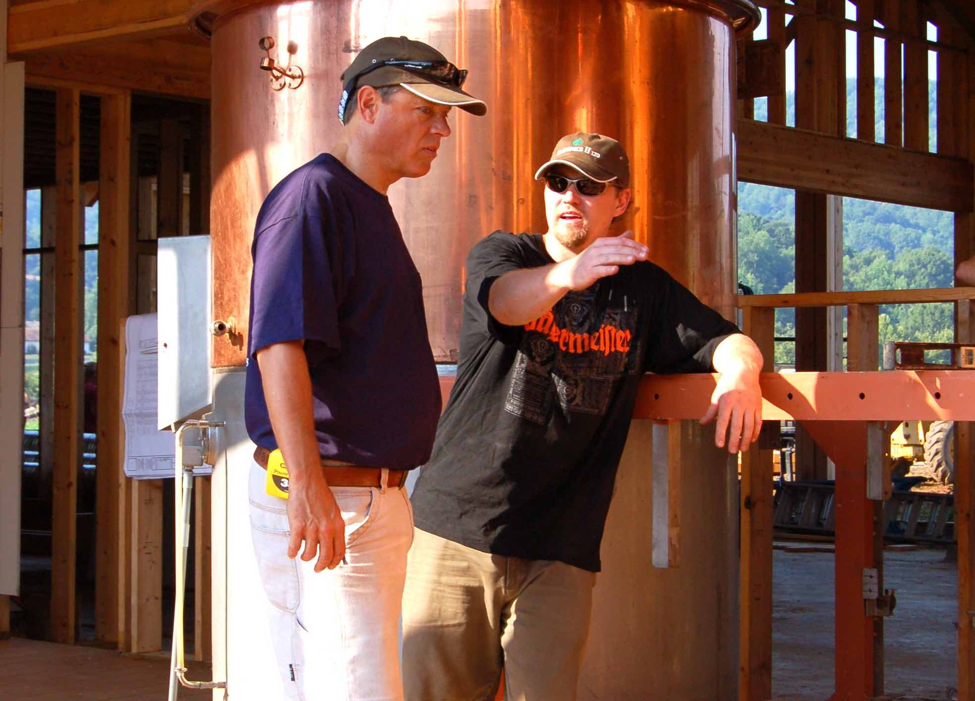
©™2008-2016 Nelson County Life Magazine & Blue Ridge Life Magazine : Photos By Tommy Stafford : Back in August of 2008 Devils Backbone Founder Steve Crandall (left) listens as Head Brewmaster Jason Oliver discusses placement of brewing pots in what's now Devils Backbone Brewpub & Meadows. In the shot above the walls of the brewery and restaurant hadn't even been put on yet. :
©™2008-2016 Nelson County Life Magazine & Blue Ridge Life Magazine : Photos By Tommy Stafford : Back in August of 2008 Devils Backbone Founder Steve Crandall (left) listens as Head Brewmaster Jason Oliver discusses placement of brewing pots in what’s now Devils Backbone Brewpub & Meadows. In the shot above the walls of the brewery and restaurant hadn’t even been put on yet.

Roseland
Nelson County, Virginia

Eight years ago in November 2008 Devils Backbone Brewing opened their doors for business. Even long before the building started we showed you the tanks coming over from Japan in
this post.

This past Saturday night – November 19, 2016 many of the original crew and founders celebrated the 8th anniversary of the restaurant that’s now expanded into many states. It sold to ABInBev within the past six months as well.

To see more photos from the 8th Anniversary at DBBC, click on our Facebook album above.

Congrats to DBBC on 8 great years!

Juky 2008. The construction crew of Devils Backbone Brewing poses in front of the shell of the building before completion.

More here on the history of DBBC.

Amherst : Crews Continue Battling Wildfire Against Brisk Winds : Updated : 12 Noon – 11.21.16 with US Forest Service Info

1

Photo Courtesy of Jake Campbell : Heavy smoke blankets an area near Big Mt. Pleasant easily Sunday morning. Crews have been battling the blaze there since Saturday evening.
Photo Courtesy of Jake Campbell : Heavy smoke blankets an area near Big Mt. Pleasant early Sunday morning. Crews have been battling the blaze there since Saturday evening.


Near Thrasher’s Lake
Amherst County, Virginia

Updated 12 noon – November 21, 2016 

Information from US Forest Service in Roanoke regarding Mt Pleasant fire in Amherst:

Via US Forest Service regarding Amherst wildfire:

Wildfire Burning in Mount Pleasant National Scenic Area

Natural Bridge, Va. – 11/21/2016 – The USDA Forest Service is working with the Virginia Department of Forestry to contain a wildfire burning on the George Washington National Forest and private land in and around the Mount Pleasant National Scenic Area in Amherst County.
The fire is estimated to be 1200 acres in size. Strong winds and low humidity contributed to the rapid spread of the fire on Sunday. The fire is located north of Thrashers Creek.
Firefighters are building hand and dozer lines to contain the fire and a helicopter is dropping water with the priority on areas south of the fire where structures are threatened. Approximately 70 firefighters and support staff including two wildland engines, a dozer and 2 aircraft are assigned to this incident with additional resources being mobilized.
Thrasher’s Creek Road (SR) 617 is closed at Molly’s Mountain due to firefighting activities. Local traffic will be permitted.
As a result of the fire the Mount Pleasant National Scenic Area is closed to public entry including the following roads and trails:
• Hog Camp Gap Road (FR #48) from Hog Camp Gap to Salt Log Gap
• North Fork of Buffalo Road (FR #51)
• Coon Bridge Road (FR #1167)
• Appalachian Trail (FT #1) from Long Mountain Wayside to Salt Pond Gap
• Old Hotel Trail (FT #515)
• Henry Lanum Trail (FT #702)
• Mt. Pleasant Trail (FT #704)
• and trailheads associated with these trails.
The fire was discovered on Saturday evening. The cause is under investigation.
There is currently a fire ban on the George Washington & Jefferson National Forests to maintain public safety and protect forest resources during extreme drought. Building, maintaining, or using a fire, campfire or stove fire is prohibited on National Forest lands outside of developed recreation areas. For more information regarding the fire ban contact your local Ranger District office or visit the forest website at www.fs.usda.gov/gwj.
-USFS-

Crews continue their fight this Sunday against a wildfire in Amherst County. Many of our Facebook friends have posted saying they still see thick smoke Sunday morning as far north as Lowesville and continue seeing fire on the mountainside.

Photo By Stephanie Madison : The orange glow of a wildfire burning in Amherst County in the general vicinity of Thrashers Lake can be seen off in the distance above the roofline of this house. Saturday - November 19, 2016
Photo By Stephanie Madison : The orange glow of a wildfire burning in Amherst County in the general vicinity of Thrashers Lake can be seen off in the distance above the roofline of this house. Saturday – November 19, 2016
According to a story posted by ABC-13 on Saturday evening:

“When firefighters arrived, they located the fire on Big Mt. Pleasant, in a remote area of the US Forest Service property. The Amherst County fire department warns that residents in the area along with people traveling on Route 60 will see a great deal of smoke due to the fire and windy conditions.”

Extremely high winds and very dry conditions are working against firefighters as they battle the blaze.

A RED FLAG WARNING is in effect all day ask day for very high fire danger across the area.

Snowmaking Begins At Wintergreen

0
Photo courtesy of Wintergreen Resort : With temps dropping well into the 20s at Wintergreen, that has allowed crews there to start making snow.

Wintergreen Resort
Nelson County, Virginia

With the winds howling and temps dropping like a rock the snow fans at Wintergreen Resort have kicked in and snowmaking has started.

By early Saturday evening temps had already dropped into the upper 20s at Wintergreen with wind gusts of just over 70 MPH recorded.

While the slopes are a very long way from being ready, this was the official first step.

If conditions work in their favor, Wintergreen could open the slopes in the not too distant future.

Stay tuned!

Red Flag Warning : CANCELLED

0
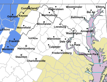
Via NWS : The areas highlighted in read are at a high risk for wildfires into early evening Sunday 11.20.15
Via NWS : The areas highlighted in red are at a high risk for wildfires into early evening Sunday 11.20.15

AUGUSTA-ROCKINGHAM-SHENANDOAH-PAGE-WARREN-NELSON-ALBEMARLE-GREENE-
MADISON-RAPPAHANNOCK-ORANGE-CULPEPER-STAFFORD-SPOTSYLVANIA-
KING GEORGE-NORTHERN VIRGINIA BLUE RIDGE-
CENTRAL VIRGINIA BLUE RIDGE-
425 PM EST SUN NOV 20 2016

…RED FLAG WARNING IS CANCELLED FOR CENTRAL VIRGINIA…

THE NATIONAL WEATHER SERVICE IN STERLING VIRGINIA HAS CANCELLED
THE RED FLAG WARNING FOR THIS EVENING.

WHILE GUSTY WINDS CONTINUE…RELATIVE HUMIDITIES HAVE RISEN ABOVE
CRITERIA.

RED FLAG WARNING – CANCELLED
URGENT – FIRE WEATHER MESSAGE
NATIONAL WEATHER SERVICE BALTIMORE MD/WASHINGTON DC
346 AM EST SUN NOV 20 2016

AUGUSTA-ROCKINGHAM-SHENANDOAH-FREDERICK VA-PAGE-WARREN-CLARKE-
NELSON-ALBEMARLE-GREENE-MADISON-RAPPAHANNOCK-ORANGE-CULPEPER-
STAFFORD-SPOTSYLVANIA-KING GEORGE-NORTHERN VIRGINIA BLUE RIDGE-
CENTRAL VIRGINIA BLUE RIDGE-
346 AM EST SUN NOV 20 2016

…RED FLAG WARNING IN EFFECT FROM 8 AM THIS MORNING TO 7 PM EST
THIS EVENING FOR STRONG WINDS AND LOW HUMIDITIES FOR CENTRAL
AND WESTERN VIRGINIA AND THE PIEDMONT…

THE NATIONAL WEATHER SERVICE IN STERLING VIRGINIA HAS ISSUED A
RED FLAG WARNING FOR STRONG WINDS AND LOW HUMIDITIES…WHICH IS
IN EFFECT FROM 8 AM THIS MORNING TO 7 PM EST THIS EVENING. THE
FIRE WEATHER WATCH IS NO LONGER IN EFFECT.

* HUMIDITY…25 TO 30 PERCENT.

* WINDS…WEST 20 TO 30 MPH WITH GUSTS UP TO 50 MPH.

* FUEL MOISTURE…5 TO 8 PERCENT.

* IMPACTS…ANY FIRES THAT DEVELOP MAY QUICKLY GET OUT OF
CONTROL AND BECOME DIFFICULT TO CONTAIN.

PRECAUTIONARY/PREPAREDNESS ACTIONS…

A RED FLAG WARNING MEANS THAT CRITICAL FIRE WEATHER CONDITIONS
ARE EITHER OCCURRING NOW….OR WILL SHORTLY. A COMBINATION OF
STRONG WINDS…LOW RELATIVE HUMIDITY…AND WARM TEMPERATURES CAN
CONTRIBUTE TO EXTREME FIRE BEHAVIOR.

URGENT – FIRE WEATHER MESSAGE
NATIONAL WEATHER SERVICE BLACKSBURG VA
209 AM EST SUN NOV 20 2016

…RED FLAG WARNING TODAY MAINLY EAST OF THE BLUE RIDGE…
INCLUDING THE ROANOKE AND SOUTHERN SHENANDOAH VALLEYS…

.VERY DRY AIR WILL BE POURING IN ON GUSTY NORTHWEST WINDS TODAY.
THE COMBINATION OF WINDS…LOW HUMIDITY AND DRY FUELS WILL
INCREASE THE RISK OF WILDFIRE SPREAD.

ROANOKE-BOTETOURT-ROCKBRIDGE-PATRICK-FRANKLIN-BEDFORD-AMHERST-
HENRY-PITTSYLVANIA-CAMPBELL-APPOMATTOX-BUCKINGHAM-HALIFAX-
CHARLOTTE-
209 AM EST SUN NOV 20 2016

…RED FLAG WARNING IN EFFECT FROM 8 AM THIS MORNING TO 7 PM EST
THIS EVENING FOR WIND AND LOW HUMIDITY FOR THE VIRGINIA FOOTHILLS
AND PIEDMONT…AS WELL AS THE SOUTHERN SHENANDOAH AND ROANOKE
VALLEYS….

THE NATIONAL WEATHER SERVICE IN BLACKSBURG HAS ISSUED A RED FLAG
WARNING FOR WIND AND LOW HUMIDITY…WHICH IS IN EFFECT FROM 8 AM
THIS MORNING TO 7 PM EST THIS EVENING. THE FIRE WEATHER WATCH IS
NO LONGER IN EFFECT.

* AFFECTED AREA…IN VIRGINIA…FIRE WEATHER ZONE 022 ROANOKE…
FIRE WEATHER ZONE 023 BOTETOURT…FIRE WEATHER ZONE 024
ROCKBRIDGE…FIRE WEATHER ZONE 032 PATRICK…FIRE WEATHER ZONE
033 FRANKLIN…FIRE WEATHER ZONE 034 BEDFORD…FIRE WEATHER
ZONE 035 AMHERST…FIRE WEATHER ZONE 043 HENRY…FIRE WEATHER
ZONE 044 PITTSYLVANIA…FIRE WEATHER ZONE 045 CAMPBELL…FIRE
WEATHER ZONE 046 APPOMATTOX…FIRE WEATHER ZONE 047
BUCKINGHAM… FIRE WEATHER ZONE 058 HALIFAX AND FIRE WEATHER
ZONE 059 CHARLOTTE.

* TIMING…MAINLY THIS AFTERNOON.

* WINDS…WEST 10 TO 20 MPH WITH GUSTS 35 TO 50 MPH.

* RELATIVE HUMIDITY…AS LOW AS 20 TO 30 PERCENT.

* TEMPERATURES…IN THE 40S.

* IMPACTS…ANY FIRES THAT START WILL SPREAD RAPIDLY.

PRECAUTIONARY/PREPAREDNESS ACTIONS…

A RED FLAG WARNING MEANS THAT CRITICAL FIRE WEATHER CONDITIONS
ARE EITHER OCCURRING NOW….OR WILL SHORTLY. A COMBINATION OF
STRONG WINDS…LOW RELATIVE HUMIDITY…AND WARM TEMPERATURES CAN
CONTRIBUTE TO EXTREME FIRE BEHAVIOR.

FOR MORE INFORMATION FROM NOAA/NATIONAL WEATHER SERVICE VISIT…
HTTP://WWW.ERH.NOAA.GOV/ER/RNK/EMER/EMER_FIRE.PHP (ALL LOWER CASE)

Fire Weather Watch – Replaced With Red Flag Warning

0
Via NWS : A FIRE WEATHER WATCH will be in effect from Sunday morning through Sunday evening for much of the Blue Ridge.

A RED FLAG WARNING (HIGH FIRE DANGER) NOW COVERS THE AREA. CLICK HERE FOR THAT UPDATE

FIRE WEATHER WATCH REMAINS IN EFFECT FROM SUNDAY MORNING THROUGH SUNDAY EVENING
URGENT – FIRE WEATHER MESSAGE
NATIONAL WEATHER SERVICE BALTIMORE MD/WASHINGTON DC
252 PM EST SAT NOV 19 2016

DISTRICT OF COLUMBIA-PRINCE GEORGES-ANNE ARUNDEL-CHARLES-
ST. MARYS-CALVERT-NORTHWEST MONTGOMERY-
CENTRAL AND SOUTHEAST MONTGOMERY-NORTHWEST HOWARD-
CENTRAL AND SOUTHEAST HOWARD-AUGUSTA-ROCKINGHAM-SHENANDOAH-
FREDERICK VA-PAGE-WARREN-CLARKE-NELSON-ALBEMARLE-GREENE-MADISON-
RAPPAHANNOCK-ORANGE-CULPEPER-
PRINCE WILLIAM/MANASSAS/MANASSAS PARK-FAIRFAX-
ARLINGTON/FALLS CHURCH/ALEXANDRIA-STAFFORD-SPOTSYLVANIA-
KING GEORGE-NORTHERN FAUQUIER-SOUTHERN FAUQUIER-WESTERN LOUDOUN-
EASTERN LOUDOUN-NORTHERN VIRGINIA BLUE RIDGE-
CENTRAL VIRGINIA BLUE RIDGE-
252 PM EST SAT NOV 19 2016

…FIRE WEATHER WATCH REMAINS IN EFFECT FROM SUNDAY MORNING
THROUGH SUNDAY EVENING FOR STRONG WINDS AND LOW HUMIDITY…WHICH
IS IN EFFECT FOR NORTHERN AND CENTRAL VIRGINIA…CENTRAL AND
SOUTHERN MARYLAND AND THE WASHINGTON METROPOLITAN AREA.

* HUMIDITY…25 TO 30 PERCENT.

* WINDS…NORTHWEST 20 TO 30 MPH WITH GUSTS AROUND 50 MPH.

* FUEL MOISTURE…5 TO 8 PERCENT

* IMPACTS…ANY FIRES THAT DEVELOP MAY QUICKLY GET OUT OF CONTROL
AND BECOME DIFFICULT TO CONTAIN.

PRECAUTIONARY/PREPAREDNESS ACTIONS…

A FIRE WEATHER WATCH MEANS THAT CRITICAL FIRE WEATHER CONDITIONS
ARE FORECAST TO OCCUR. LISTEN FOR LATER FORECASTS AND POSSIBLE
RED FLAG WARNINGS.

URGENT – FIRE WEATHER MESSAGE
NATIONAL WEATHER SERVICE BLACKSBURG VA
207 PM EST SAT NOV 19 2016

…FIRE WEATHER WATCH FOR SUNDAY EAST OF THE BLUE
RIDGE…INCLUDING THE ROANOKE AND SOUTHERN SHENANDOAH VALLEYS…

.VERY DRY AIR WILL BE POURING IN ON GUSTY NORTHWEST WINDS SUNDAY.
THE COMBINATION OF WINDS…LOW HUMIDITY AND DRY FUELS WILL
INCREASE THE RISK OF WILDFIRE SPREAD.

ROANOKE-BOTETOURT-ROCKBRIDGE-PATRICK-FRANKLIN-BEDFORD-AMHERST-
HENRY-PITTSYLVANIA-CAMPBELL-APPOMATTOX-BUCKINGHAM-HALIFAX-
CHARLOTTE-
207 PM EST SAT NOV 19 2016

…FIRE WEATHER WATCH IN EFFECT SUNDAY FOR WIND AND LOW RELATIVE
HUMIDITY FOR THE VIRGINIA FOOTHILLS AND PIEDMONT…AS WELL AS THE
SOUTHERN SHENANDOAH AND ROANOKE VALLEY…

THE NATIONAL WEATHER SERVICE IN BLACKSBURG HAS ISSUED A FIRE
WEATHER WATCH FOR WIND AND LOW RELATIVE HUMIDITY…WHICH IS IN
EFFECT FROM SUNDAY MORNING THROUGH SUNDAY EVENING.

* AFFECTED AREA…VIRGINIA FOOTHILLS AND PIEDMONT…INCLUDING THE
SOUTHERN SHENANDOAH AND ROANOKE VALLEYS.

* WINDS…NORTHWEST 10 TO 20 MPH WITH GUSTS 35 TO 50 MPH.

* RELATIVE HUMIDITY…AS LOW AS 20 TO 30 PERCENT.

* IMPACTS…ANY FIRES THAT START WILL SPREAD RAPIDLY.

PRECAUTIONARY/PREPAREDNESS ACTIONS…

A FIRE WEATHER WATCH MEANS THAT CRITICAL FIRE WEATHER CONDITIONS
ARE FORECAST TO OCCUR. LISTEN FOR LATER FORECASTS AND POSSIBLE
RED FLAG WARNINGS.

- Advertisement -