WINTER WEATHER ADVISORY
URGENT – WINTER WEATHER MESSAGE
National Weather Service Baltimore MD/Washington DC
619 AM EST Fri Mar 1 2019
Augusta-Western Highland-Eastern Highland-
Central Virginia Blue Ridge-
619 AM EST Fri Mar 1 2019
…WINTER WEATHER ADVISORY REMAINS IN EFFECT UNTIL 10 AM EST THIS
MORNING…
* WHAT…Freezing drizzle with an additional light glaze of ice,
mainly across the higher elevations above 1000 feet.
* WHERE…Augusta and Highland Counties, and the Central
Virginia Blue Ridge.
* WHEN…Through 10 AM EST this morning. The widespread
precipitation has ended, however areas of freezing drizzle
remain, mainly above 1000 feet.
* ADDITIONAL DETAILS…Plan on slippery road conditions.
PRECAUTIONARY/PREPAREDNESS ACTIONS…
A Winter Weather Advisory means that periods of snow, sleet or
freezing rain will cause travel difficulties. Expect slippery
roads and limited visibilities, and use caution while driving.
When venturing outside, watch your first few steps taken on
steps, sidewalks, and driveways, which could be icy and slippery,
increasing your risk of a fall and injury.
Zone Forecast Product
National Weather Service Baltimore MD/Washington DC
636 AM EST Fri Mar 1 2019
VAZ508-011500-
Central Virginia Blue Ridge-
Including the city of Wintergreen
637 AM EST Fri Mar 1 2019
…WINTER WEATHER ADVISORY IN EFFECT UNTIL 10 AM EST THIS
MORNING…
.TODAY…Cloudy with patchy drizzle and freezing drizzle. A
chance of light freezing rain or light rain or light sleet this
morning, then freezing rain or light rain likely this afternoon.
Little or no sleet accumulation. Ice accumulation of up to a
tenth of an inch. Highs in the lower 30s. East winds 5 to 10 mph.
Chance of precipitation 60 percent.
.TONIGHT…Freezing rain or rain, mainly in the evening. Ice
accumulation of up to a tenth of an inch. Lows in the lower 30s.
Northeast winds 5 to 10 mph, becoming northwest after midnight.
Chance of precipitation 90 percent.
.SATURDAY…Partly sunny. Highs in the upper 40s. West winds 5 to
10 mph.
.SATURDAY NIGHT…Mostly cloudy. Lows in the lower 30s. Northwest
winds 5 to 10 mph.
.SUNDAY…Cloudy. A chance of rain or freezing rain in the
morning, then rain in the afternoon. Highs in the upper 30s.
Southeast winds 5 to 10 mph. Chance of precipitation 90 percent.
.SUNDAY NIGHT…Rain or a chance of snow. Lows in the upper 20s.
Chance of precipitation 90 percent.
.MONDAY…Mostly sunny. Highs in the mid 30s.
.MONDAY NIGHT…Mostly clear. Cold with lows around 20.
.TUESDAY…Mostly sunny. Highs in the lower 30s.
.TUESDAY NIGHT…Mostly clear. Cold with lows 10 to 15. Wind
chill values as low as zero.
.WEDNESDAY…Sunny. Highs around 30. Wind chill values as low as
zero.
.WEDNESDAY NIGHT…Mostly clear. Cold with lows around 20.
.THURSDAY…Mostly sunny. Highs in the upper 30s.
URGENT – WINTER WEATHER MESSAGE
National Weather Service Blacksburg VA
544 AM EST Fri Mar 1 2019
Bath-Rockbridge-Amherst-
Including the cities of Hot Springs, Lexington, Buena Vista,
and Amherst
544 AM EST Fri Mar 1 2019
…WINTER WEATHER ADVISORY REMAINS IN EFFECT UNTIL NOON EST
TODAY…
* WHAT…Light freezing rain or freezing drizzle. Trace of ice
along the higher ridges.
* WHERE…Rockbridge, Amherst and Bath Counties.
* WHEN…Until noon EST today.
* ADDITIONAL DETAILS…The hazardous conditions could impact the
morning commute, mainly on roads in the higher ridges.
PRECAUTIONARY/PREPAREDNESS ACTIONS…
This Winter Weather Advisory means that light freezing rain and
freezing drizzle will cause travel difficulties, mainly in the
higher ridges. Use caution while driving.
The latest road conditions for the state you are calling from can
be obtained by calling 5 1 1.
Click on the image above for the absolute latest updates and additional weather alert products from NWS.
HIGH WIND WARNING
URGENT – WEATHER MESSAGE
National Weather Service Baltimore MD/Washington DC
1058 AM EST Sun Feb 24 2019
Western Highland-Eastern Highland-Northern Virginia Blue Ridge-
Central Virginia Blue Ridge-Western Grant-Eastern Grant-
Western Mineral-Western Pendleton-Eastern Pendleton-
Including the cities of Hightown, Monterey, Big Meadows,
Wintergreen, Bayard, Mount Storm, Petersburg, Elk Garden,
Riverton, Brandywine, Franklin, Oak Flat, Ruddle, and Sugar Grove
1058 AM EST Sun Feb 24 2019
…HIGH WIND WARNING REMAINS IN EFFECT UNTIL 10 AM EST MONDAY…
* TIMING…Late this morning through Monday morning. The
strongest winds are expected tonight through daybreak Monday.
* WINDS…West 35 to 45 mph with gusts up to 65 mph.
* IMPACTS…Damaging winds will blow down trees, especially
given the saturated ground and prolonged nature of the winds.
Power outages are expected. Travel will be difficult,
especially for high profile vehicles. Minor structural damage
is possible.
PRECAUTIONARY/PREPAREDNESS ACTIONS…
A High Wind Warning means a hazardous high wind event is expected
or occurring. Sustained wind speeds of at least 40 mph or gusts
of 58 mph or more can lead to property damage.
Zone Forecast Product
National Weather Service Baltimore MD/Washington DC
1237 PM EST Sun Feb 24 2019
VAZ508-242100-
Central Virginia Blue Ridge- Including the city of Wintergreen
1237 PM EST Sun Feb 24 2019
…HIGH WIND WARNING IN EFFECT UNTIL 10 AM EST MONDAY…
.THIS AFTERNOON…Mostly sunny and very windy. Not as cool with
highs in the upper 50s. Temperature falling into the upper 40s.
West winds 30 to 40 mph with gusts up to 60 mph.
.TONIGHT…Clear and very windy. Lows in the upper 20s. West
winds 30 to 40 mph, diminishing to 20 to 30 mph after midnight.
Gusts up to 60 mph.
.MONDAY…Sunny, windy with highs in the lower 40s. Northwest
winds 20 to 30 mph. Gusts up to 60 mph, decreasing to 45 mph in
the afternoon.
.MONDAY NIGHT…Clear. Lows in the upper 20s. West winds 15 to
20 mph with gusts up to 30 mph.
.TUESDAY…Sunny. Highs in the mid 40s. West winds 5 to 10 mph.
URGENT – WEATHER MESSAGE
National Weather Service Blacksburg VA
852 AM EST Sun Feb 24 2019
…Strong Gusty Winds Expected today into Monday Morning…
NCZ003-004-019-020-VAZ032>035-043-242200-
/O.CON.KRNK.HW.W.0005.190224T1700Z-190225T1700Z/
Surry-Stokes-Wilkes-Yadkin-Patrick-Franklin-Bedford-Amherst-Henry-
Including the cities of Dobson, Danbury, Wilkesboro, Yadkinville,
Stuart, Rocky Mount, Bedford, Amherst, and Martinsville
852 AM EST Sun Feb 24 2019
…HIGH WIND WARNING REMAINS IN EFFECT FROM NOON TODAY TO NOON
EST MONDAY…
* Winds…West 15 to 25 mph with gusts up to 50 mph.
* Timing…this afternoon into Monday morning.
* Impacts…Tree limbs will be blown down. Trees in waterlogged
soil will topple over, increasing the potential for power
outages. Driving high profile vehicles will be very difficult.
* Locations…East of the Blue Ridge into the foothills.
* Hazards…Strong wind gusts.
PRECAUTIONARY/PREPAREDNESS ACTIONS…
A High Wind Warning means a hazardous high wind event is expected
or occurring. Sustained wind speeds are likely to cause power
outages…fallen trees… property damage…and dangerous driving
conditions for high profile vehicles. Move unfastened items…
such as garbage cans and deck furniture…indoors.
For the absolute latest updates from NWS – click on the image above.
URGENT – WINTER WEATHER MESSAGE
National Weather Service Baltimore MD/Washington DC
257 PM EST Fri Feb 22 2019
Western Highland-Eastern Highland-Central Virginia Blue Ridge-
Western Pendleton-Eastern Pendleton-
257 PM EST Fri Feb 22 2019
…WINTER WEATHER ADVISORY IN EFFECT FROM 3 AM TO NOON EST
SATURDAY…
* WHAT…Freezing rain expected. Total ice accumulations around
one-tenth of an inch expected.
* WHERE…In Virginia, Western Highland and Eastern Highland
Counties, and Central Virginia Blue Ridge. In West Virginia,
Western Pendleton and Eastern Pendleton Counties.
* WHEN…From 3 AM to noon EST Saturday.
* ADDITIONAL DETAILS…Ice may create slippery travel and walking
conditions in some areas.
PRECAUTIONARY/PREPAREDNESS ACTIONS…
A Winter Weather Advisory means that periods of freezing rain
will cause travel difficulties. Expect slippery roads. Slow down
and use caution while driving.
When venturing outside, watch your first few steps taken on
steps, sidewalks, and driveways, which could be icy and slippery,
increasing your risk of a fall and injury.
Zone Forecast Product
National Weather Service Baltimore MD/Washington DC
336 PM EST Fri Feb 22 2019
Central Virginia Blue Ridge- Including the city of Wintergreen
336 PM EST Fri Feb 22 2019
…WINTER WEATHER ADVISORY IN EFFECT FROM 3 AM TO NOON EST
SATURDAY…
…FLOOD WATCH IN EFFECT FROM SATURDAY AFTERNOON THROUGH LATE
SATURDAY NIGHT…
…HIGH WIND WATCH IN EFFECT FROM SUNDAY MORNING THROUGH MONDAY
MORNING…
.REST OF THIS AFTERNOON…Cloudy with a 50 percent chance of
rain. Highs in the lower 40s. Southeast winds around 5 mph.
.TONIGHT…A chance of rain in the evening, then rain or freezing
rain likely after midnight. Ice accumulation around a trace. Lows
in the lower 30s. East winds around 5 mph. Chance of
precipitation 70 percent.
.SATURDAY…Rain or freezing rain in the morning, then rain in
the afternoon. Ice accumulation of up to a tenth of an inch.
Highs in the upper 30s. Southeast winds 5 to 10 mph. Chance of
precipitation near 100 percent.
.SATURDAY NIGHT…Rain. Lows in the upper 30s. South winds 5 to
10 mph, increasing to southwest 15 to 20 mph after midnight.
Chance of rain near 100 percent.
.SUNDAY…Mostly cloudy with showers likely in the morning, then
mostly sunny in the afternoon. Very windy and much warmer with
highs in the lower 60s. Temperature falling into the lower 50s in
the afternoon. Southwest winds 15 to 25 mph with gusts up to
50 mph, increasing to west 25 to 35 mph with gusts up to 60 mph
in the afternoon. Chance of rain 60 percent.
.SUNDAY NIGHT…Mostly clear and windy. Lows in the lower 30s.
.MONDAY…Sunny, breezy with highs in the lower 40s.
.MONDAY NIGHT…Mostly clear. Lows in the upper 20s.
.TUESDAY…Mostly sunny. Highs in the mid 40s.
.TUESDAY NIGHT…Partly cloudy. Lows in the upper 20s.
.WEDNESDAY…Partly sunny. Highs in the mid 40s.
.WEDNESDAY NIGHT…Mostly cloudy. Lows in the upper 20s.
.THURSDAY…Mostly sunny. Highs in the lower 40s.
URGENT – WEATHER MESSAGE
National Weather Service Baltimore MD/Washington DC
139 PM EST Fri Feb 22 2019
Extreme Western Allegany-Western Highland-Eastern Highland-
Northern Virginia Blue Ridge-Central Virginia Blue Ridge-
Western Grant-Eastern Grant-Western Mineral-Western Pendleton-
Eastern Pendleton-
Including the cities of Frostburg, Hightown, Monterey,
Big Meadows, Wintergreen, Bayard, Mount Storm, Petersburg,
Elk Garden, Riverton, Brandywine, Franklin, Oak Flat, Ruddle,
and Sugar Grove
139 PM EST Fri Feb 22 2019
…HIGH WIND WATCH IN EFFECT FROM SUNDAY MORNING THROUGH MONDAY
MORNING…
The National Weather Service in Baltimore MD/Washington has
issued a High Wind Watch, which is in effect from Sunday morning
through Monday morning.
* TIMING…10 AM Sunday morning through 10 AM Monday morning.
* WINDS…Southwest late Sunday morning becoming west to northwest
Sunday afternoon through Monday morning around 25 to 40 mph
with the potential for gusts around 60 mph. The strongest winds
are most likely over the higher elevations above 1500 feet.
* IMPACTS…There is the potential for downed trees, powerlines,
and minor structural damage. Driving high profile vehicles in
these conditions is dangerous.
PRECAUTIONARY/PREPAREDNESS ACTIONS…
A High Wind Watch means there is the potential for a hazardous
high wind event. Sustained winds of at least 40 mph, or gusts of
58 mph or stronger may occur. Continue to monitor the latest
forecasts.
Flood Watch
National Weather Service Baltimore MD/Washington DC
258 PM EST Fri Feb 22 2019
Augusta-Nelson-Western Highland-Eastern Highland-
Central Virginia Blue Ridge-
Including the cities of Staunton, Waynesboro, Stuarts Draft,
Lovingston, Hightown, Monterey, and Wintergreen
258 PM EST Fri Feb 22 2019
…FLOOD WATCH IN EFFECT FROM SATURDAY AFTERNOON THROUGH LATE
SATURDAY NIGHT…
The National Weather Service in Sterling Virginia has issued a
* Flood Watch for Augusta, Highland, Nelson, and the central
Virginia Blue Ridge Mountains.
* From Saturday afternoon through late Saturday night.
* Rain is expected through Saturday night, and the steadiest rain
is expected Saturday afternoon and night. Most likely rainfall
amounts will be around around three quarters of an inch to one
and one-half inches.
* Excess runoff due to saturated soil from recent snow melt and
the rain that is expected may cause creeks and streams to rise
out of their banks as well as the potential of flooding in low
lying urban areas.
PRECAUTIONARY/PREPAREDNESS ACTIONS…
A Flood Watch means there is a potential for flooding based on
current forecasts.
You should monitor later forecasts and be alert for possible
Flood Warnings. Those living in areas prone to flooding should be
prepared to take action should flooding develop.
Flood Watch
National Weather Service Blacksburg VA
250 PM EST Fri Feb 22 2019
…Additional Moderate to Heavy Rainfall Possible Late Tonight
into Saturday Night…
.A slow moving warm front lifts northward from the Southeast U.S.
into the mid-Atlantic through Sunday morning followed quickly by a
cold front. An extended period of rain, moderate to heavy at times
will impact the area late tonight into Saturday night.
Surry-Stokes-Rockingham-Caswell-Wilkes-Yadkin-Roanoke-Botetourt-
Rockbridge-Patrick-Franklin-Bedford-Amherst-Henry-Pittsylvania-
Campbell-Appomattox-Buckingham-Halifax-Charlotte-
Including the cities of Dobson, Danbury, Eden, Yanceyville,
Wilkesboro, Yadkinville, Roanoke, Salem, Fincastle, Lexington,
Buena Vista, Stuart, Rocky Mount, Bedford, Amherst, Martinsville,
Danville, Lynchburg, Appomattox, South Boston, and Keysville
250 PM EST Fri Feb 22 2019
…FLOOD WATCH REMAINS IN EFFECT THROUGH SUNDAY MORNING…
The Flood Watch continues for
* Portions of North Carolina and Virginia, including the
following areas, in North Carolina, Caswell, Rockingham,
Stokes, Surry, Wilkes, and Yadkin. In Virginia, Amherst,
Appomattox, Bedford, Botetourt, Buckingham, Campbell,
Charlotte, Franklin, Halifax, Henry, Patrick, Pittsylvania,
Roanoke, and Rockbridge.
* Through Sunday morning
* Periods of moderate to at times heavy rain. Rainfall totals of 1
to 2 inches are expected through Sunday, with locally higher
amounts possible.
* Flooding of low-lying, poor drainage, and normally flood prone
areas. Small creeks and streams will be subject to flooding as
well as larger mainstem rivers.
* Those living along creeks, streams and rivers should be alert
to possible flooding.
PRECAUTIONARY/PREPAREDNESS ACTIONS…
A Flood Watch means there is a potential for flooding based on
current forecasts.
You should monitor later forecasts and be alert for possible
Flood Warnings. Those living in areas prone to flooding should be
prepared to take action should flooding develop.
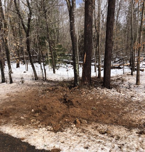
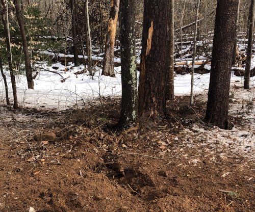
Photo By John Holman : Lots of people reported hearing an extremely loud boom of thunder on Wednesday night during the rain / sleet event near Nellysford. John Holman of Stoney Creek found where the lightning hit during the storm. This was Stoney Creek West near Wood Nettle. John says it hit two trees. February 21, 2019
Stoney Creek / Nellysford
Nelson County, VA
Though thunder and lightning are rare during the winter months it does occur. The last couple of nights folks living in Nelson and nearby have experienced lightning and thunder during snow, sleet and freezing rain. Wednesday night people were surprised to hear a loud boom. Some thinking it was an explosion. Actually, it was thunder after a large lightning strike in Stoney Creek of Nellysford.
A closer look reveals where the lightning struck Wednesday night while sleet and freezing rain were falling. This is in Stoney Creek of Nellysford. The photo was taken the next morning on Thursday – February 21, 2019.
“Rocks and dirt were blown out 30 feet,” John Holman of Stoney Creek told us when he sent these photos along.
Thankfully we get a brief break from rain but more is on the way arrive
The northbound lane of Route 151 near Goodwin Creek (that’s just north of Silverback Distillery and just south of the old Small’s / Patrick Brother’s Grocery) was blocked early Wednesday afternoon when a semi jackknifed at that location. This was just one of several accidents across the area due to ice and snow that fell overnight.
A crew from Wintergreen Fire & Rescue directs traffic around the semi accident on 151 in Afton – Wednesday afternoon – February 20, 2019The northbound lane of 151 was blocked from the jackknifed semi early Wednesday afternoon – February 20, 2019.
No work on how long the cleanup and delays will be. We will keep you updated as we know.
For the absolute latest updates from NWS, click on the image above.
Not much to change on this graphic. Here's a timeline of what to expect and when to expect it across the region. Temperatures do climb above freezing later Wednesday evening, but pockets of freezing rain will be possible, especially in the mountains. #vawx#Charlottesvillepic.twitter.com/3gVXcF4n9y
WINTER STORM WARNING
URGENT – WINTER WEATHER MESSAGE
National Weather Service Baltimore MD/Washington DC
207 PM EST Tue Feb 19 2019
Augusta-Rockingham-Nelson-Albemarle-Greene-Western Highland-
Eastern Highland-Northern Virginia Blue Ridge-
Central Virginia Blue Ridge-Western Pendleton-Eastern Pendleton–
207 PM EST Tue Feb 19 2019
…WINTER STORM WARNING REMAINS IN EFFECT FROM 10 PM THIS EVENING
TO 10 PM EST WEDNESDAY…
* WHAT…Heavy mixed precipitation expected. Total snow
accumulations of 4 to 6 inches and ice accumulations of one
tenth to two tenths of an inch expected.
* WHERE…Portions of central and western Virginia as well as
portions of eastern West Virginia.
* WHEN…From 10 PM this evening to 10 PM EST Wednesday. Snow will
overspread the area late this evening, and mix with and change
to sleet and freezing rain Wednesday morning. The heaviest snow
is likely in the pre-dawn hours Wednesday morning.
* ADDITIONAL DETAILS…Travel could be very difficult. The
hazardous conditions could impact the morning or evening
commute.
PRECAUTIONARY/PREPAREDNESS ACTIONS…
A Winter Storm Warning means significant amounts of snow, sleet
and ice will make travel very hazardous or impossible.
When venturing outside, watch your first few steps taken on
steps, sidewalks, and driveways, which could be icy and slippery,
increasing your risk of a fall and injury.
URGENT – WINTER WEATHER MESSAGE
National Weather Service Blacksburg VA
324 PM EST Tue Feb 19 2019
…Expect winter weather this evening into late Wednesday…
.A strong area of high pressure will shift into the northeastern
United States, allowing cold air to wedge south along the eastern
face of the Appalachians. A winter storm approaching from the
west Gulf region will spread precipitation over this shallow dome
of cold air, producing a wintry mixture of snow, sleet and
freezing rain for large part of the Mid Atlantic region and
central Appalachians.
Alleghany VA-Bath-Botetourt-Rockbridge-Bedford-Amherst-Campbell-
Appomattox-Buckingham-Eastern Greenbrier-Western Greenbrier-
Including the cities of Clifton Forge, Covington, Hot Springs,
Fincastle, Lexington, Buena Vista, Amherst, Lynchburg,
Appomattox, Lewisburg, White Sulphur Springs, Quinwood, Duo,
and Rainelle
324 PM EST Tue Feb 19 2019
…WINTER STORM WARNING REMAINS IN EFFECT UNTIL MIDNIGHT EST
WEDNESDAY NIGHT…
* WHAT…Heavy mixed precipitation expected. Total snow and sleet
accumulations of 3 to 5 inches and ice accumulations of up to
one quarter of an inch expected.
* WHERE…Portions of central, south central and west central
Virginia and southeast West Virginia.
* WHEN…Until midnight EST Wednesday night.
* ADDITIONAL DETAILS…Plan on slippery road conditions. The
hazardous conditions could impact the morning or evening
commute.
For the absolute latest updates from NWS, click on the image above.
WINTER STORM WARNING IN EFFECT FROM 6 PM TUESDAY TO MIDNIGHT EST WEDNESDAY NIGHT
URGENT – WINTER WEATHER MESSAGE
National Weather Service Blacksburg VA
333 PM EST Mon Feb 18 2019
…Expect wintry weather to impact the area late Tuesday
afternoon into late Wednesday…
.A strong area of high pressure will shifts east into the
Northeast United States, this will result in cold air wedging
down the Appalachians. As a winter storm lifts northeast across
our region, precipitation will spread north over this shallow
dome of cold air, producing a wintry mixture of snow, sleet and
freezing rain.
Alleghany VA-Bath-Botetourt-Rockbridge-Bedford-Amherst-Campbell-
Appomattox-Buckingham-Eastern Greenbrier-Western Greenbrier-
Including the cities of Clifton Forge, Covington, Hot Springs,
Fincastle, Lexington, Buena Vista, Amherst, Lynchburg,
Appomattox, Lewisburg, White Sulphur Springs, Quinwood, Duo,
and Rainelle
333 PM EST Mon Feb 18 2019
…WINTER STORM WARNING IN EFFECT FROM 6 PM TUESDAY TO MIDNIGHT
EST WEDNESDAY NIGHT…
* WHAT…Heavy mixed precipitation expected. Total snow and sleet
accumulations of 1 to 3 inches…with locally higher amounts across
the Alleghanys and Blue Ridge. Ice accumulations of one tenth
to three tenths of an inch expected.
* WHERE…Portions of central, south central and west central
Virginia and southeast West Virginia.
* WHEN…From 6 PM Tuesday to midnight EST Wednesday night.
* ADDITIONAL DETAILS…Power outages and tree damage are likely
due to the ice. Travel could be nearly impossible. The
hazardous conditions could impact the morning or evening
commute.
PRECAUTIONARY/PREPAREDNESS ACTIONS…
A Winter Storm Warning means significant amounts of snow, sleet
and ice will make travel very hazardous or impossible.
The latest road conditions for the state you are calling from can
be obtained by calling 5 1 1.
URGENT – WINTER WEATHER MESSAGE
National Weather Service Baltimore MD/Washington DC
126 PM EST Mon Feb 18 2019
District of Columbia-Washington-Frederick MD-Carroll-
Northern Baltimore-Southern Baltimore-Prince Georges-Anne Arundel-
Extreme Western Allegany-Central and Eastern Allegany-
Northwest Montgomery-Central and Southeast Montgomery-
Northwest Howard-Central and Southeast Howard-Northwest Harford-
Southeast Harford-Augusta-Rockingham-Shenandoah-Frederick VA-Page-
Warren-Clarke-Nelson-Albemarle-Greene-Madison-Rappahannock-Orange-
Culpeper-Prince William/Manassas/Manassas Park-Fairfax-
Arlington/Falls Church/Alexandria-Stafford-Spotsylvania-
Northern Fauquier-Southern Fauquier-Western Highland-
Eastern Highland-Western Loudoun-Eastern Loudoun-
Northern Virginia Blue Ridge-Central Virginia Blue Ridge-
Hampshire-Morgan-Berkeley-Jefferson-Hardy-Western Grant-
Eastern Grant-Western Mineral-Eastern Mineral-Western Pendleton-
Eastern Pendleton-
126 PM EST Mon Feb 18 2019
…WINTER STORM WATCH REMAINS IN EFFECT FROM TUESDAY EVENING
THROUGH WEDNESDAY EVENING…
* WHAT…Heavy snow, mixing with and eventually changing to
sleet and then freezing rain. Snow accumulations of 5 or more
inches and ice accumulations of a quarter-inch or greater are
possible.
* WHERE…The District of Columbia, Maryland east of the
Alleghany Front and west of the Chesapeake Bay, central and
northern Virginia, and the eastern West Virginia panhandle.
* WHEN…From Tuesday evening through Wednesday evening.
* ADDITIONAL DETAILS…Travel could be very difficult. The
hazardous conditions could impact the morning and evening
commute.
PRECAUTIONARY/PREPAREDNESS ACTIONS…
A Winter Storm Watch means there is potential for significant
snow, sleet or ice accumulations that may impact travel. Continue
to monitor the latest forecasts.
WINTER STORM WATCH IN EFFECT FROM TUESDAY EVENING THROUGH WEDNESDAY EVENING
URGENT – WINTER WEATHER MESSAGE
National Weather Service Baltimore MD/Washington DC
338 AM EST Mon Feb 18 2019
District of Columbia-Washington-Frederick MD-Carroll-
Northern Baltimore-Southern Baltimore-Prince Georges-Anne Arundel-
Extreme Western Allegany-Central and Eastern Allegany-
Northwest Montgomery-Central and Southeast Montgomery-
Northwest Howard-Central and Southeast Howard-Northwest Harford-
Southeast Harford-Augusta-Rockingham-Shenandoah-Frederick VA-Page-
Warren-Clarke-Nelson-Albemarle-Greene-Madison-Rappahannock-Orange-
Culpeper-Prince William/Manassas/Manassas Park-Fairfax-
Arlington/Falls Church/Alexandria-Stafford-Spotsylvania-
Northern Fauquier-Southern Fauquier-Western Highland-
Eastern Highland-Western Loudoun-Eastern Loudoun-
Northern Virginia Blue Ridge-Central Virginia Blue Ridge–
Hampshire-Morgan-Berkeley-Jefferson-Hardy-Western Grant-
Eastern Grant-Western Mineral-Eastern Mineral-Western Pendleton-
Eastern Pendleton-
338 AM EST Mon Feb 18 2019
…WINTER STORM WATCH IN EFFECT FROM TUESDAY EVENING THROUGH
WEDNESDAY EVENING…
* WHAT…Heavy snow, mixing with and eventually changing to sleet
and then freezing rain. Snow accumulations of 5 or more inches
and ice accumulations of a quarter-inch or greater are possible.
* WHERE…The District of Columbia, Maryland east of the
Appalachians and west of the Chesapeake Bay, central and
northern Virginia, and the eastern West Virginia panhandle.
* WHEN…From Tuesday evening through Wednesday evening.
* ADDITIONAL DETAILS…Travel could be very difficult. The
hazardous conditions could impact the morning or evening
commute.
PRECAUTIONARY/PREPAREDNESS ACTIONS…
A Winter Storm Watch means there is potential for significant
snow, sleet or ice accumulations that may impact travel. Continue
to monitor the latest forecasts.
URGENT – WINTER WEATHER MESSAGE
National Weather Service Blacksburg VA
328 AM EST Mon Feb 18 2019
…Winter weather expected from Tuesday afternoon into Wednesday
afternoon…
.A strong area of high pressure will shifts east into the
Northeast United States, this will result in cold air wedging
down the Appalachians. As a winter storm lifts northeast across
our region, precipitation will spread north over this shallow dome
of cold air, producing a wintery mixture of snow, sleet and
freezing rain across our region. The storm is still evolving and
the amounts and precipitation types will likely change over time.
Ashe-Alleghany NC-Surry-Watauga-Wilkes-Tazewell-Smyth-Bland-Giles-
Wythe-Pulaski-Montgomery-Grayson-Carroll-Floyd-Craig-Alleghany VA-
Bath-Roanoke-Botetourt-Rockbridge-Patrick-Franklin-Bedford-
Amherst-Henry-Pittsylvania-Campbell-Appomattox-Buckingham-Mercer-
Summers-Monroe-Eastern Greenbrier-Western Greenbrier-
Including the cities of West Jefferson, Sparta, Dobson, Boone,
Wilkesboro, Tazewell, Marion, Bland, Pearisburg, Wytheville,
Radford, Pulaski, Blacksburg, Independence, Whitetop, Troutdale,
Volney, Galax, Floyd, New Castle, Clifton Forge, Covington,
Hot Springs, Roanoke, Salem, Fincastle, Lexington, Buena Vista,
Stuart, Rocky Mount, Amherst, Martinsville, Danville, Lynchburg, Appomattox, Bluefield, Hinton, Hix, Union, Lewisburg,
White Sulphur Springs, Quinwood, Duo, and Rainelle
328 AM EST Mon Feb 18 2019
…WINTER STORM WATCH IN EFFECT FROM TUESDAY AFTERNOON THROUGH
WEDNESDAY AFTERNOON…
* WHAT…Heavy mixed precipitation possible. Total snow
accumulations will vary from light amounts in the piedmont to
heavy snows in Southeast West Virginia and Alleghany highlands
of Virginia. The highest amounts of snow will occur in western
Greenbrier where 4 to 8 inches are possible. Ice accumulations
will range from a light glaze to around one quarter of an inch.
* WHERE…Portions of southwest Virginia, northwest North
Carolina and southeast West Virginia.
* WHEN…From Tuesday afternoon through Wednesday afternoon.
* ADDITIONAL DETAILS…Power outages and tree damage are likely
due to the ice. Travel could be nearly impossible. The hazardous
conditions could impact the morning and evening commutes.
PRECAUTIONARY/PREPAREDNESS ACTIONS…
A Winter Storm Watch means there is potential for significant
snow, sleet or ice accumulations that may impact travel. Continue
to monitor the latest forecasts.
Northern Virginia Blue Ridge-Central Virginia Blue Ridge-
904 PM EST Sun Feb 17 2019
…WINTER WEATHER ADVISORY IN EFFECT UNTIL MIDNIGHT EST TONIGHT…
* WHAT…Freezing rain. Additional ice accumulations of a light
glaze.
* WHERE…Northern Virginia Blue Ridge and Central Virginia Blue
Ridge.
* WHEN…Until midnight EST tonight.
* ADDITIONAL DETAILS…Plan on slippery road conditions.
PRECAUTIONARY/PREPAREDNESS ACTIONS…
A Winter Weather Advisory means that periods of freezing rain
will cause travel difficulties. Expect slippery roads. Slow down
and use caution while driving.
When venturing outside, watch your first few steps taken on
steps, sidewalks, and driveways, which could be icy and slippery,
increasing your risk of a fall and injury.
CANCELED
Nelson-Northern Virginia Blue Ridge-Central Virginia Blue Ridge-
750 PM EST Sun Feb 17 2019
…WINTER WEATHER ADVISORY IS CANCELLED…
Temperatures have risen above freezing. The threat for freezing
rain is ending.
WINTER WEATHER ADVISORY
URGENT – WINTER WEATHER MESSAGE
National Weather Service Baltimore MD/Washington DC
354 AM EST Sun Feb 17 2019
Nelson
354 AM EST Sun Feb 17 2019
…WINTER WEATHER ADVISORY IN EFFECT FROM 11 AM THIS MORNING TO
9 PM EST THIS EVENING…
* WHAT…Freezing rain mixed with sleet. Total sleet accumulation
of less than an inch. Ice accumulations of a light glaze
expected.
* WHERE…Nelson County.
* WHEN…From 11 AM this morning to 9 PM EST this evening.
* ADDITIONAL DETAILS…Plan on slippery road conditions.
PRECAUTIONARY/PREPAREDNESS ACTIONS…
A Winter Weather Advisory means that periods of snow, sleet or
freezing rain will cause travel difficulties. Expect slippery
roads and limited visibilities, and use caution while driving.
When venturing outside, watch your first few steps taken on
steps, sidewalks, and driveways, which could be icy and slippery,
increasing your risk of a fall and injury.
URGENT – WINTER WEATHER MESSAGE
National Weather Service Baltimore MD/Washington DC
354 AM EST Sun Feb 17 2019
Augusta-Rockingham-Western Highland-Eastern Highland-
Northern Virginia Blue Ridge-Central Virginia Blue Ridge-
Western Pendleton-Eastern Pendleton-
354 AM EST Sun Feb 17 2019
…WINTER WEATHER ADVISORY REMAINS IN EFFECT FROM 11 AM THIS
MORNING TO 9 PM EST THIS EVENING…
* WHAT…Freezing rain mixed with sleet. Total sleet accumulation
of less than an inch. Ice accumulations of up to one tenth of
an inch expected.
* WHERE…The Central Shenandoah Valley, northern and central Blue
Ridge, Highland County Virginia, and Pendleton County West
Virginia.
* WHEN…From 11 AM this morning to 9 PM EST this evening.
* ADDITIONAL DETAILS…Plan on slippery road conditions.
PRECAUTIONARY/PREPAREDNESS ACTIONS…
A Winter Weather Advisory means that periods of snow, sleet or
freezing rain will cause travel difficulties. Expect slippery
roads and limited visibilities, and use caution while driving.
When venturing outside, watch your first few steps taken on
steps, sidewalks, and driveways, which could be icy and slippery,
increasing your risk of a fall and injury.
URGENT – WINTER WEATHER MESSAGE
National Weather Service Blacksburg VA
517 AM EST Sun Feb 17 2019
…Freezing Rain Expected Sunday…
.An area of low pressure will move east through the Tennesse and
Ohio Valleys today. A swath of precipitation will overspread the
region from southwest to northeast ahead of this system. Freezing
rain is likely primarily across the higher elevations from the New
River Valley northeast into the Shenandoah Valley and Highlands
of Virginia, and the Greenbrier Valley and Highlands of West
Virgina.
VAZ018>020-023-024-034-035-171900-
/O.CON.KRNK.WW.Y.0014.190217T1400Z-190218T0000Z/
Craig-Alleghany VA-Bath-Botetourt-Rockbridge-Bedford-Amherst-
Including the cities of New Castle, Clifton Forge, Covington,
Hot Springs, Fincastle, Lexington, Buena Vista, and Amherst
517 AM EST Sun Feb 17 2019
…WINTER WEATHER ADVISORY REMAINS IN EFFECT FROM 9 AM THIS
MORNING TO 7 PM EST THIS EVENING…
* WHAT…Freezing rain expected. Total ice accumulations of a
light glaze expected, up to two-tenths of an inch on the
highest ridges.
* WHERE…Portions of central, south central, southwest and west
central Virginia.
* WHEN…From 9 AM this morning to 7 PM EST this evening.
* ADDITIONAL DETAILS…Most of the ice accretion will be on
elevated surfaces.
PRECAUTIONARY/PREPAREDNESS ACTIONS…
A Winter Weather Advisory means that periods of freezing rain
will cause travel difficulties. Expect slippery roads. Slow down
and use caution while driving.
The latest road conditions for the state you are calling from can
be obtained by calling 5 1 1.
Copyright 2019 Blue Ridge Life Magazine : Photo By Tommy Stafford : Crime scene tape surrounds a car in front of Wintergreen Fire Department Station 2 in Stoney Creek of Nellysford. A woman who had been shot multiple times drove the car to the fire station seeking help after the shooting. She was airlifted to UVA Medical Center in Charlottesville. February 14, 2019
Nellysford
Nelson County, Virginia
UPDATE in Nelson County Shootings Investigation from VSP : 4:45 PM-Deceased shooter identified
“The Virginia State Police investigation continues into the shootings that occurred overnight at a residence in Nellysford.
The first shooting occurred shortly after 9 p.m. Thursday (Feb. 14) when James C. Saunderson, 47, and a 45-year-old female got into an argument at their residence in the 800 block of Rodes Valley Drive. During the course of the argument, Saunderson began firing a handgun at the female, who was able to flee the residence in her vehicle.
She drove herself to a Wintergreen Fire Department station and was transported to UVA Medical Center. She is still being treated for serious, but non-life threatening, injuries.
The Nelson County Sheriff’s Office immediately responded to the residence on Rodes Valley Drive. As the deputies approached the residence, they heard gunshots fired from inside the house.
The Virginia State Police was requested to respond to the scene and set up a perimeter around the house to contain the scene. Despite numerous attempts throughout the night by state police, no contact was made with the individual inside the residence.
A search warrant was obtained for the residence. Upon making entry into the residence Friday morning, the Virginia State Police Tactical Team located Saunderson inside and deceased. A handgun was recovered at the scene. His remains have been transported to the Office of the Medical Examiner for autopsy and examination.
There was no one else inside the residence when Saunderson was found. No law enforcement personnel discharged their weapons during the course of the incident.
The investigation remains ongoing at this time.
Corinne N. Geller
Public Relations Director
Virginia State Police”
Updated 7:45 AM
VSP release verbatim below:
“The Virginia State Police Bureau of Criminal Investigation’s Appomattox Field Office is investigating two shootings that took place at a residence in the Stoney Creek community of Nelson County.
The incident began shortly after 9 p.m. Thursday (Feb. 14) when an adult female drove herself to a Wintergreen Fire Department station. The woman had been shot and was transported to UVA Medical Center. She is still being treated for serious injuries.
The Nelson County Sheriff’s Office immediately responded to a nearby residence on Rodes Valley Drive. As the deputies approached the residence, they heard gunshots fired from inside the house.
The Virginia State Police was requested to respond to the scene and set up a perimeter around the house to contain the subject inside. Despite numerous attempts by state police overnight, no contact was made with the individual inside the residence.
A search warrant was obtained for the residence. Upon making entry into the residenceFriday morning, the Virginia State Police Tactical Team located a deceased adult male inside. A firearm was recovered at the scene.
The male subject is believed to be the individual who shot the woman several hours earlier. The investigation remains ongoing at this time.”
Updated 6:15 AM – 2.15.19
Area safe. Apparent shooter found dead. More details to released by VSP soon.
Updated at 2:30 AM : 2.15.19
The investigation continues into a bizarre scenario that unfolded Thursday night between and 8 and 9:00 PM. BRL first broke the story (in this post) about a woman that showed up at the front entrance of WFD Station 2 in Stoney Creek after being shot multiple times. Once emergency personnel found out the woman was there she was treated, transported to a waiting helicopter and flown to UVa Medical Center.
“A woman in her mid 40’s drove to the Wintergreen Fire Station in Stoney Creek. She had been shot multiple times. She is not a resident of Stoney Creek. We do not know the exact shooting location. She was flown to UVA Medical Center. The suspect is still at large as far as we know,” Jay Roberts – Executive Director of Wintergreen Property Owners Association told us Thursday night shortly after the shooting. Roberts and WPOA oversee police and fire operations in Stoney Creek and Wintergreen.
Above our original video post shortly after learning of the shooting
In the very early morning hours on Friday – February 15, 2019 BRL learned that law enforcement had gathered around a house in Stoney Creek where the suspect is believed to have possibly been inside. Neighbors in the area reported an extremely heavy police presence consisting of large numbers of Virginia State Police as well as Nelson Sheriff’s officers and additional officers from Wintergreen Police. As of 2:30 AM when this post was made on our site, no law enforcement updates had been given as to whether a suspect was at large or if the situation had been secured.
We will continue to update this story as we have additional information.