Davis Creek Land
North of Lovingston
Nelson County, Virginia
Verbatim press release from Virginia State Police
Updated from VSP 8.10.19 5 PM
“Virginia State Police Trooper T.A. Hackenbracht is investigating a fatal crash in Nelson County. The crash occurred Aug. 9, 2019 at 7:19 p.m. on Route 623, west of Route 29.
A 2014 Nissan Pathfinder was traveling west on Route 623 when it ran off the right side of the road and struck a tree. The impact of the crash caused the vehicle to catch fire.
The driver, Tiffany A. Spencer, 44, of Lovingston, Va., did not survive the crash.
She was not wearing a seat belt.
The crash remains under investigation.
Corinne N. Geller
Public Relations Director
Virginia State Police“
At 7:32 p.m. Friday (Aug. 9), Virginia State Police responded to a single-vehicle crash in Nelson County. The crash occurred in the 1600 block of Davis Creek Lane and there is one confirmed fatality. The crash remains under investigation.
Corinne N. Geller
Public Relations Director
Virginia State Police”
Photo By Michelle Ashwell : Traffic was backed up on US 29 late Friday morning after a vehicle accident involving a Virginia State Trooper occurred at the traffic light. August 9, 2019
Lovingston
Nelson County, Virginia
Verbatim press release from VSP at 3:13 PM Friday afternoon :
“At approximately 10:47 a.m. (Aug. 9), Virginia State Police Trooper B.W. Stanley was traveling south on Route 29 and approaching the intersection at Front Street in Lovingston. The stoplight at the intersection turned red but the vehicle traveling in front of the trooper ran the red light. The trooper activated his lights and sirens and was proceeding through the intersection to stop the violator when a 2015 Chrysler 500 came through the intersection. The Chrysler was traveling west on Front Street and struck the trooper’s car in the side.
Trooper Stanley was transported to UVA Medical Center for treatment of non-life threatening injuries. The trooper was wearing a seat belt. He was driving a marked Ford Taurus.
The driver of the Chrysler, Robert O. Banks, 80, of Shipman, Va., was not injured in the crash. He was wearing a seat belt.
The crash remains under investigation.
Corinne N. Geller
Public Relations Director
Virginia State Police“
Original post:
A late morning traffic accident in Lovingston stopped drivers on US 29 at the traffic light. A Virginia State Trooper was involved in the accident.
File photo : Publicity – file Nelson CA Daniel Rutherford pictured above.
Lovingston
Nelson County, VA
Verbatim release from Nelson CA’s office
FROM:DANIEL L RUTHERFORD, NELSON COUNTY COMMONWEALTH’S ATTORNEY.
Thursday morning, Nelson County Commonwealth’s Attorney Daniel Rutherford announced that on August 7, 2019, a jury in Nelson County convicted Leslie Bishop Sr, from Staunton, of racketeering. The jury recommended a total of 5 years incarceration for the charge.
Leslie Bishop Sr. was charged with one count of racketeering for his involvement in a corrupt organization of individuals that trafficked drugs into Nelson County and Central Virginia from November 1, 2016 through November 1, 2018. This charge stems from a lengthy investigation by the Virginia State Police Bureau of Criminal Investigation’s Appomattox Field Office, the Skyline Drug Task Force, the Jefferson Area Drug Enforcement (J.A.D.E.) Task Force, the Nelson County Sheriff’s Office and the Office of the Commonwealth’s Attorney for Nelson County.
The jury deliberated for three hours before returning a guilty verdict. After further deliberation on sentencing, including evidence of the defendant’s previous convictions, the jury recommended a sentence of 5 years for the racketeering.
Daniel Rutherford, the Commonwealth’s Attorney and Erik Laub, the Deputy Commonwealth’s Attorney, prosecuted this case. Dana Cormier from Staunton, Virginia represented Leslie Bishop, Sr.
“The jury’s finding represents a unique accomplishment by the Nelson County Commonwealth’s Attorney Office. We have used a legal tool by which those that participate in complex criminal organizations trafficking drugs can be prosecuted for their participation both inside and outside of Nelson County.”
Formal sentencing is scheduled for 3:00 p.m. on November 12, 2019 in the Nelson County Circuit Court.
Virginia State Police is investigating a two-vehicle crash in Amherst County. The crash occurred Sunday (Aug. 4) at 4:56 p.m. on the Route 29 Bypass near the Route 210 on-ramp.
A Suzuki motorcycle was traveling north in the right lane on the Route 29 Bypass. According to witnesses, as the motorcycle was attempting to merge into the left lane, it rear-ended a tractor-trailer traveling ahead of it in the right, northbound lane.
The adult, male motorcyclist died at the scene. State police is still in the process of locating and notifying the next of kin.
The tractor-trailer driver was not injured in the crash.
The Virginia State Police Appomattox Division’s Crash Reconstruction Team and the state police Motor Carrier Safety Team responded to the scene to assist with the ongoing investigation.
Corinne N. Geller
Public Relations Director
Virginia State Police
The scene in Lovingston Tuesday afternoon where a fatal semi / car accident occurred. One NB lane remains closed in the location of the accident as of 7:45 PM – July 30, 2019
Lovingston Nelson County, Virginia
The following information was received from VSP on 8.6.19 identifying the victim in the crash.
“Virginia State Police Trooper B. Stanley is investigating a two-vehicle fatal crash in Nelson County. The crash occurred July 30, 2019 at 5:31 p.m. on Route 29 at the intersection of Northside Lane.
A 2018 Chevrolet Cruze was traveling south on Route 29 when it attempted to make a left turn onto Northside Lane. The Chevrolet pulled across the northbound lanes of Route 29 and the path of a northbound tractor-trailer. The tractor-trailer was unable to stop in time and struck the Chevrolet in the side.
The driver of the Chevrolet, Gail J. Mankie, 70, of Norwood, Va., died at the scene. She was wearing a seat belt.
The driver of the tractor-trailer, Nathan L. Creason, 33, of Russiaville, Ind., was not injured in the crash. He was wearing a seat belt.
The crash remains under investigation.
Corinne N. Geller
Public Relations Director
Virginia State Police“
Updated: 7:45 PM : BRL has learned the accident is being worked as a fatal. More info as we know.
“At 5:36 p.m. Tuesday, Virginia State Police responded to a crash in Nelson County. The crash occurred in the northbound lanes of Route29 near Front Street in Lovingston. There is one confirmed fatality. The crash remains under investigation.
Corinne N. Geller
Public Relations Director
Virginia State Police”
Updated: 6:05 PM : To add VDOT info: One lane of US 29 NB closed now at scene
Updated: 5:55 PM : US 29 NB from Front Street & Main Streets will remain closed for an extended period of time. Use an alternate route.
TRAFFIC ALERT: One lane of US29N near 29B, Lovingston area of Nelson County is closed due to a crash. Expect delays and please watch out for emergency responders. #MoveOver#FlashingRedBlueandAmber
Photo By BRLM Photog Kat Turner : Northbound 29 in Lovingston as seen from the southbound side at the scene of a serious tractor trailer accident near the car wash on US 29 NB. July 30, 2019
US 29 northbound in Lovington north of the traffic light in the vicinity of the car wash remains closed at this hour due to a tractor trailer accident.
Photo By BRLM Photographer Katherine Turner : Traffic was at a standstill Monday afternoon on US 29 near the Apple Shed after strong winds associated with severe thunderstorms brought down numerous trees. July 22, 2019
Nelson County, VA
Severe thunderstorms that moved into Nelson County from adjoining counties to the south caused widespread wind damage late Monday afternoon. Areas along US 29 from the Amherst / Nelson line were especially hard it.
A screenshot from the CVEC outage site showed over 3000 people across the region without power when this image was saved at 7:04 PM – Monday evening : July 22, 2019. Click on image above for the latest outage information.
Numerous trees reported down in Nelson US 29 near St Mary’s Church 29 SB & Nelson High. 29 SN Another on Craigtown Rd blocking entries road. @DurkinWeather@CBS19Weather
Both trees and power lines were down across US 29 in multiple locations. Fire and road crews were working into the evening hours Monday to clear the highway and get it back open to traffic.
Photo By BRLM Photographer Katherine Turner : Crews from Lovingston Volunteer Fire Department stop to help clear trees from US 29 late Monday afternoon – July 22, 2019.
At 7:15 PM crews were still working to clear many roads across Northeast Nelson.
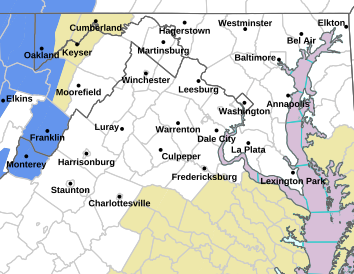
From the Storm Prediction Center : A Severe Thunderstorm Watch continues for all of the areas shaded in blue until 10 PM – Monday night July 22, 2019. Some Central Virginia counties (including Nelson) are in the watch. Click on the image above for the latest watches and warnings affecting the State of Virginia.
The areas highlighted in pink are under a Severe Thunderstorm Watch until 10 PM Monday night. The adjacent green area are under a Flood Watch. July 22, 2019. Click image above for the latest updates from NWS.
URGENT - IMMEDIATE BROADCAST REQUESTED
   Severe Thunderstorm Watch Number 538
   NWS Storm Prediction Center Norman OK
   215 PM EDT Mon Jul 22 2019

   The NWS Storm Prediction Center has issued a

   * Severe Thunderstorm Watch for portions of
     Connecticut
     District Of Columbia
     Delaware
     Eastern Maryland
     New Jersey
     Southern New York
     Southeast Pennsylvania
     Rhode Island
     Eastern Virginia
     Coastal Waters

   * Effective this Monday afternoon and evening from 215 PM until
     1000 PM EDT.

   * Primary threats include...
     Scattered damaging wind gusts to 70 mph likely
     A tornado or two possible

   SUMMARY...Scattered thunderstorms will continue to develop and
   intensify within a moist/moderately unstable air mass to the east of
   a cold front. Winds aloft should be sufficient for organized
   multicells, with a couple of transient supercells also possible.
   Damaging winds are the most likely risk as storms progress
   east-northeastward through late afternoon and evening.

   The severe thunderstorm watch area is approximately along and 70
   statute miles north and south of a line from 15 miles north
   northwest of Charlottesville VA to 20 miles south southeast of
   Providence RI. For a complete depiction of the watch see the
   associated watch outline update (WOUS64 KWNS WOU8).

   PRECAUTIONARY/PREPAREDNESS ACTIONS...

   REMEMBER...A Severe Thunderstorm Watch means conditions are
   favorable for severe thunderstorms in and close to the watch area.
   Persons in these areas should be on the lookout for threatening
   weather conditions and listen for later statements and possible
   warnings. Severe thunderstorms can and occasionally do produce
   tornadoes.


   BULLETIN - IMMEDIATE BROADCAST REQUESTED
   SEVERE THUNDERSTORM WATCH OUTLINE UPDATE FOR WS 538
   NWS STORM PREDICTION CENTER NORMAN OK
   215 PM EDT MON JUL 22 2019

   SEVERE THUNDERSTORM WATCH 538 IS IN EFFECT UNTIL 1000 PM EDT
   FOR THE FOLLOWING LOCATIONS

   CTC001-003-005-007-009-011-013-015-230200-
   /O.NEW.KWNS.SV.A.0538.190722T1815Z-190723T0200Z/

   CT
   .    CONNECTICUT COUNTIES INCLUDED ARE

   FAIRFIELD            HARTFORD            LITCHFIELD
   MIDDLESEX            NEW HAVEN           NEW LONDON
   TOLLAND              WINDHAM


   DCC001-230200-
   /O.NEW.KWNS.SV.A.0538.190722T1815Z-190723T0200Z/

   DC
   .    DISTRICT OF COLUMBIA COUNTIES INCLUDED ARE

   DISTRICT OF COLUMBIA


   DEC001-003-005-230200-
   /O.NEW.KWNS.SV.A.0538.190722T1815Z-190723T0200Z/

   DE
   .    DELAWARE COUNTIES INCLUDED ARE

   KENT                 NEW CASTLE          SUSSEX


   MDC003-005-009-011-013-015-017-019-021-025-027-029-031-033-035-
   037-039-041-045-047-510-230200-
   /O.NEW.KWNS.SV.A.0538.190722T1815Z-190723T0200Z/

   MD
   .    MARYLAND COUNTIES INCLUDED ARE

   ANNE ARUNDEL         BALTIMORE           CALVERT
   CAROLINE             CARROLL             CECIL
   CHARLES              DORCHESTER          FREDERICK
   HARFORD              HOWARD              KENT
   MONTGOMERY           PRINCE GEORGES      QUEEN ANNE'S
   SOMERSET             ST. MARYS           TALBOT
   WICOMICO             WORCESTER


   MARYLAND INDEPENDENT CITIES INCLUDED ARE

   BALTIMORE CITY


   NJC001-003-005-007-009-011-013-015-017-019-021-023-025-027-029-
   031-033-035-037-039-041-230200-
   /O.NEW.KWNS.SV.A.0538.190722T1815Z-190723T0200Z/

   NJ
   .    NEW JERSEY COUNTIES INCLUDED ARE

   ATLANTIC             BERGEN              BURLINGTON
   CAMDEN               CAPE MAY            CUMBERLAND
   ESSEX                GLOUCESTER          HUDSON
   HUNTERDON            MERCER              MIDDLESEX
   MONMOUTH             MORRIS              OCEAN
   PASSAIC              SALEM               SOMERSET
   SUSSEX               UNION               WARREN


   NYC005-027-047-059-061-071-079-081-085-087-103-119-230200-
   /O.NEW.KWNS.SV.A.0538.190722T1815Z-190723T0200Z/

   NY
   .    NEW YORK COUNTIES INCLUDED ARE

   BRONX                DUTCHESS            KINGS
   NASSAU               NEW YORK            ORANGE
   PUTNAM               QUEENS              RICHMOND
   ROCKLAND             SUFFOLK             WESTCHESTER


   PAC001-011-017-025-029-043-045-071-075-077-089-091-095-101-107-
   133-230200-
   /O.NEW.KWNS.SV.A.0538.190722T1815Z-190723T0200Z/

   PA
   .    PENNSYLVANIA COUNTIES INCLUDED ARE

   ADAMS                BERKS               BUCKS
   CARBON               CHESTER             DAUPHIN
   DELAWARE             LANCASTER           LEBANON
   LEHIGH               MONROE              MONTGOMERY
   NORTHAMPTON          PHILADELPHIA        SCHUYLKILL
   YORK


   RIC001-003-005-007-009-230200-
   /O.NEW.KWNS.SV.A.0538.190722T1815Z-190723T0200Z/

   RI
   .    RHODE ISLAND COUNTIES INCLUDED ARE

   BRISTOL              KENT                NEWPORT
   PROVIDENCE           WASHINGTON


   VAC003-013-033-047-057-059-061-065-075-079-085-097-099-101-107-
   109-113-125-133-137-153-157-159-177-179-193-510-540-600-610-630-
   683-685-230200-
   /O.NEW.KWNS.SV.A.0538.190722T1815Z-190723T0200Z/

   VA
   .    VIRGINIA COUNTIES INCLUDED ARE

   ALBEMARLE            ARLINGTON           CAROLINE
   CULPEPER             ESSEX               FAIRFAX
   FAUQUIER             FLUVANNA            GOOCHLAND
   GREENE               HANOVER             KING AND QUEEN
   KING GEORGE          KING WILLIAM        LOUDOUN
   LOUISA               MADISON             NELSON
   NORTHUMBERLAND       ORANGE              PRINCE WILLIAM
   RAPPAHANNOCK         RICHMOND            SPOTSYLVANIA
   STAFFORD             WESTMORELAND


   VIRGINIA INDEPENDENT CITIES INCLUDED ARE

   ALEXANDRIA           CHARLOTTESVILLE     FAIRFAX
   FALLS CHURCH         FREDERICKSBURG      MANASSAS
   MANASSAS PARK


   ANZ235-236-237-256-330-335-338-340-345-350-353-355-430-431-450-
   451-452-453-454-455-530-531-532-533-534-535-536-537-538-539-540-
   541-542-543-230200-
   /O.NEW.KWNS.SV.A.0538.190722T1815Z-190723T0200Z/

   CW

   .    ADJACENT COASTAL WATERS INCLUDED ARE

   RHODE ISLAND SOUND

   NARRAGANSETT BAY

   BLOCK ISLAND SOUND

   COASTAL WATERS FROM MONTAUK NY TO MARTHAS VINEYARD EXTENDING OUT
   TO 20 NM SOUTH OF BLOCK ISLAND

   LONG ISLAND SOUND EAST OF NEW HAVEN CT/PORT JEFFERSON NY

   LONG ISLAND SOUND WEST OF NEW HAVEN CT/PORT JEFFERSON NY

   NEW YORK HARBOR

   PECONIC AND GARDINERS BAYS

   SOUTH SHORE BAYS FROM JONES INLET THROUGH SHINNECOCK BAY

   MORICHES INLET NY TO MONTAUK POINT NY OUT 20 NM

   FIRE ISLAND INLET NY TO MORICHES INLET NY OUT 20 NM

   SANDY HOOK NJ TO FIRE ISLAND INLET NY OUT 20 NM

   DELAWARE BAY WATERS NORTH OF EAST POINT NJ TO SLAUGHTER BEACH DE

   DELAWARE BAY WATERS SOUTH OF EAST POINT NJ TO SLAUGHTER BEACH DE

   COASTAL WATERS FROM SANDY HOOK TO MANASQUAN INLET NJ OUT 20 NM

   COASTAL WATERS FROM MANASQUAN INLET TO LITTLE EGG INLET NJ OUT 20
   NM

   COASTAL WATERS FROM LITTLE EGG INLET TO GREAT EGG INLET NJ OUT 20
   NM

   COASTAL WATERS FROM GREAT EGG INLET TO CAPE MAY NJ OUT 20 NM

   COASTAL WATERS FROM CAPE MAY NJ TO CAPE HENLOPEN DE OUT 20 NM

   COASTAL WATERS FROM CAPE HENLOPEN TO FENWICK ISLAND DE OUT 20 NM

   CHESAPEAKE BAY NORTH OF POOLES ISLAND MD

   CHESAPEAKE BAY FROM POOLES ISLAND TO SANDY POINT MD

   CHESAPEAKE BAY FROM SANDY POINT TO NORTH BEACH MD

   CHESAPEAKE BAY FROM NORTH BEACH TO DRUM POINT MD

   CHESAPEAKE BAY FROM DRUM POINT MD TO SMITH POINT VA

   TIDAL POTOMAC FROM KEY BRIDGE TO INDIAN HEAD MD

   TIDAL POTOMAC FROM INDIAN HEAD TO COBB ISLAND MD

   TIDAL POTOMAC FROM COBB ISLAND MD TO SMITH POINT VA

   PATAPSCO RIVER INCLUDING BALTIMORE HARBOR

   CHESTER RIVER TO QUEENSTOWN MD

   EASTERN BAY

   CHOPTANK RIVER TO CAMBRIDGE MD AND THE LITTLE CHOPTANK RIVER

   PATUXENT RIVER TO BROOMES ISLAND MD

   TANGIER SOUND AND THE INLAND WATERS SURROUNDING BLOODSWORTH
   ISLAND
Via NWS : HEAT ADVISORY or EXCESSIVE HEAT WARNING continues into the evening. Click on image above for absolute latest updates from NWS.
URGENT - WEATHER MESSAGE
National Weather Service Baltimore MD/Washington DC
549 AM EDT Sun Jul 21 2019

MDZ502-VAZ025>030-WVZ050-051-055-502-504-211800-
/O.CON.KLWX.HT.Y.0004.190721T1500Z-190722T0100Z/
Central and Eastern Allegany-Augusta-Rockingham-Shenandoah-
Frederick VA-Page-Warren-Hampshire-Morgan-Hardy-Eastern Grant-
Eastern Mineral-
Including the cities of Cumberland, Staunton, Waynesboro,
Stuarts Draft, Harrisonburg, Strasburg, Woodstock, Mount Jackson,
New Market, Winchester, Luray, Shenandoah, Stanley, Front Royal,
Romney, Paw Paw, Moorefield, Petersburg, Antioch, Keyser,
New Creek, Ridgeville, Russelldale, Headsville, and Fort Ashby
549 AM EDT Sun Jul 21 2019

...HEAT ADVISORY REMAINS IN EFFECT FROM 11 AM THIS MORNING TO
9 PM EDT THIS EVENING...

* HEAT INDEX VALUES..Around 100 degrees to temperatures in the
  mid 90s, and dewpoints in the lower 70s.

* IMPACTS...The heat and humidity may cause heat stress during
  outdoor exertion or extended exposure.

PRECAUTIONARY/PREPAREDNESS ACTIONS...

A Heat Advisory means that a period of high temperatures is
expected. The combination of high temperatures and high humidity
will create a situation in which heat illnesses are possible.

Take extra precautions if you work or spend time outside. When
possible, reschedule strenuous activities to early morning or
evening. Know the signs and symptoms of heat exhaustion and heat
stroke. Wear light weight and loose fitting clothing when
possible and drink plenty of water.

To reduce risk during outdoor work, the Occupational Safety and
Health Administration recommends scheduling frequent rest breaks
in shaded or air conditioned environments. Anyone overcome by
heat should be moved to a cool and shaded location. Heat stroke
is an emergency - call 911.

&&

$$
URGENT - WEATHER MESSAGE
National Weather Service Baltimore MD/Washington DC
549 AM EDT Sun Jul 21 2019

VAZ036>040-211800-
/O.CON.KLWX.HT.Y.0004.190721T1500Z-190722T0100Z/
Nelson-Albemarle-Greene-Madison-Rappahannock-
Including the cities of Lovingston, Charlottesville,
Stanardsville, Madison, and Washington
549 AM EDT Sun Jul 21 2019

...HEAT ADVISORY REMAINS IN EFFECT FROM 11 AM THIS MORNING TO
9 PM EDT THIS EVENING...

* HEAT INDEX VALUES...Around 105 degrees due to temperatures in
  the upper 90s, and dewpoints in the lower 70s.

* IMPACTS...The heat and humidity may cause heat stress during
  outdoor exertion or extended exposure.

  PRECAUTIONARY/PREPAREDNESS ACTIONS...

A Heat Advisory means that a period of high temperatures is
expected. The combination of high temperatures and high humidity
will create a situation in which heat illnesses are possible.

Take extra precautions if you work or spend time outside. When
possible, reschedule strenuous activities to early morning or
evening. Know the signs and symptoms of heat exhaustion and heat
stroke. Wear light weight and loose fitting clothing when
possible and drink plenty of water.

To reduce risk during outdoor work, the Occupational Safety and
Health Administration recommends scheduling frequent rest breaks
in shaded or air conditioned environments. Anyone overcome by
heat should be moved to a cool and shaded location. Heat stroke
is an emergency - call 911.
URGENT - WEATHER MESSAGE
National Weather Service Blacksburg VA
553 AM EDT Sun Jul 21 2019

...Excessive Heat Expected This Afternoon...

.Strong high pressure aloft will remain across the region through
this evening resulting in another afternoon and evening of above
normal temperatures. High temperatures will once again climb into
the mid to upper 90s. Combine this with dewpoints in the lower to
mid 70s and the heat index will rise to values in the 105 to 110
degree range.


NCZ005-006-VAZ034-035-044-045-212100-
/O.CON.KRNK.HT.Y.0002.000000T0000Z-190722T0300Z/
Rockingham-Caswell-Bedford-Amherst-Pittsylvania-Campbell-
Including the cities of Eden, Yanceyville, Bedford, Amherst,
Danville, and Lynchburg
553 AM EDT Sun Jul 21 2019

...HEAT ADVISORY REMAINS IN EFFECT UNTIL 11 PM EDT THIS EVENING...

* Heat Index Values...103 to 108 degrees due to temperatures in
  the mid to upper 90s, and dewpoints around 70.

* Timing...Highest heat indices are expected during the afternoon
  with lingering effects into the evening.

* Impacts...Prolonged exposure or any strenuous activity may
  lead to heat related illnesses that require immediate medical
  attention.

* Locations...Parts of the Virginia and North Carolina Piedmont
  and foothills.

* Hazards...Elevated heat indices.

PRECAUTIONARY/PREPAREDNESS ACTIONS...

A Heat Advisory means high humidities are expected to combine
with hot temperatures to make it feel like it is 105 degrees or
greater. This combination will increase the likelihood of heat
illnesses. Drink plenty of fluids...stay in an air-conditioned
room...stay out of the sun...check on relatives and neighbors...
and provide shade and fresh water for outdoor animals.

Take extra precautions...if you work or spend time outside.  When
possible...reschedule strenuous activities to early morning or
evening. Know the signs and symptoms of heat exhaustion and heat
stroke. Wear lightweight and loose fitting clothing when possible
and drink plenty of water.

To reduce risk during outdoor work...the Occupational Safety and
Health Administration recommends scheduling frequent rest breaks
in shaded or air conditioned environments. Anyone overcome by
heat should be moved to a cool and shaded location.   Heat stroke
is an emergency...call 9 1 1.
URGENT - WEATHER MESSAGE
National Weather Service Blacksburg VA
553 AM EDT Sun Jul 21 2019

...Excessive Heat Expected This Afternoon...

.Strong high pressure aloft will remain across the region through
this evening resulting in another afternoon and evening of above
normal temperatures. High temperatures will once again climb into
the mid to upper 90s. Combine this with dewpoints in the lower to
mid 70s and the heat index will rise to values in the 105 to 110
degree range.


VAZ046-047-058-059-212100-
/O.CON.KRNK.EH.W.0001.000000T0000Z-190722T0300Z/
Appomattox-Buckingham-Halifax-Charlotte-
Including the cities of Appomattox, South Boston, and Keysville
553 AM EDT Sun Jul 21 2019

...EXCESSIVE HEAT WARNING REMAINS IN EFFECT UNTIL 11 PM EDT THIS
EVENING...

* Heat Index Values...Up to around 110 degrees due to
  temperatures in the upper 90s, and dewpoints in the mid 70s.

* Timing...Excessively high heat indices are expected for the
  afternoon and evening.

* Impacts...Prolonged exposure or any strenuous activity may
  lead to heat related illnesses that require immediate medical
  attention.

* Locations...Parts of the Virginia Piedmont.

* Hazards...Excessively high heat indices.

PRECAUTIONARY/PREPAREDNESS ACTIONS...

Take extra precautions...if you work or spend time outside. When
possible...reschedule strenuous activities to early morning or
evening. Know the signs and symptoms of heat exhaustion and heat
stroke. Wear light weight and loose fitting clothing when
possible and drink plenty of water.

To reduce risk during outdoor work...the Occupational Safety and
Health Administration recommends scheduling frequent rest breaks
in shaded or air conditioned environments. Anyone overcome by
heat should be moved to a cool and shaded location. Heat stroke
is an emergency...call 9 1 1.

An Excessive Heat Warning means that a prolonged period of
dangerously hot temperatures will occur. The combination of hot
temperatures and high humidity will combine to create a DANGEROUS
SITUATION in which heat illnesses are likely. Drink plenty of
fluids...stay in an air-conditioned room...stay out of the sun...
and check up on relatives and neighbors.

Young children and pets should never be left unattended in
vehicles under any circumstances. This is especially true during
warm or hot weather when car interiors can reach lethal
temperatures in a matter of minutes.
Via NWS : The areas highlighted in orange under a heat advisory on Friday – July 19, 2019. An EXCESSIVE HEAT WATCH goes into effect over the weekend. Click on the image above for the latest updates.
HEAT ADVISORY TODAY : EXCESSIVE HEAT WATCH OVER WEEKEND
Nelson-Albemarle-Greene-Madison-Rappahannock-Orange-Culpeper- Including the cities of Lovingston, Charlottesville, Stanardsville, Madison, Washington, Orange, Gordonsville, and Culpeper 352 AM EDT Fri Jul 19 2019
…HEAT ADVISORY REMAINS IN EFFECT FROM 11 AM THIS MORNING TO 9 PM EDT THIS EVENING… …EXCESSIVE HEAT WATCH IN EFFECT FROM SATURDAY MORNING THROUGH SATURDAY EVENING… …EXCESSIVE HEAT WATCH IN EFFECT FROM SUNDAY MORNING THROUGH SUNDAY EVENING…
The National Weather Service in Baltimore MD/Washington has issued an Excessive Heat Watch, which is in effect from Saturday morning through Saturday evening. An Excessive Heat Watch has also been issued from Sunday morning through Sunday evening.
* HEAT INDEX VALUES…105 to 109 degrees this afternoon, then potentially around 110 degrees or greater Saturday and Sunday due to temperatures in the upper 90s to around 100 degrees and dewpoints in the lower to middle 70s.
* IMPACTS…Dangerously high temperatures and humidity could quickly cause heat stress or heat stroke if precautions are not taken.
PRECAUTIONARY/PREPAREDNESS ACTIONS…
A Heat Advisory means that a period of high temperatures is expected. The combination of high temperatures and high humidity will create a situation in which heat illnesses are possible.
An Excessive Heat Watch means that a prolonged period of dangerously high temperatures is possible. Prepare for extreme temperatures and high humidity which would create a situation in which heat illnesses are expected.
Take extra precautions if you work or spend time outside. When possible, reschedule strenuous activities to early morning or evening. Know the signs and symptoms of heat exhaustion and heat stroke. Wear light weight and loose fitting clothing when possible and drink plenty of water.
To reduce risk during outdoor work, the Occupational Safety and Health Administration recommends scheduling frequent rest breaks in shaded or air conditioned environments. Anyone overcome by heat should be moved to a cool and shaded location. Heat stroke is an emergency – call 911.
Photo by Nikki Chambers :Smoke can be seen rising from a fully involved house fire near the intersection of Rhue Hollow Road and Horseshoe Mountain Road on Monday afternoon – July 15, 2019. Severe thunderstorms with intense lightning were in the area minutes before. But the cause is not known yet.
Beech Grove
Nelson County, Virginia
Fire crews from area departments responded to the scene of a full involved house fire near the intersection of Horseshoe Mountain Road just off of Rhue Hollow Road. Multiple fire departments responded.
Fire crews stage to battle a fully involved house fire Monday afternoon – July 15, 2019 in Beech Grove of Nelson County, Virginia.
Severe thunderstorms with intense lightning were in the area minutes before. But the cause is not known yet.