In what’s become our annual tradition here at BRL, enjoy this special radio interview from the December 2011 Christmas season as Nelson native Earl Hamner, Jr. talks with BRL Publisher Tommy Stafford and Memphis KWAM 990 Radio host, Earle Farrell. Press the orange play button above and listen for over an hour as Earl reminisces about his career, life in the Virginia Blue Ridge and more.
And be sure to check out one of our favorite recipes for the Christmas season. Applesauce cake made by Earl’s mother. Click here to view that.
Be sure to listen toward the end as Earl reads a special Christmas tribute remarking about the late Will Geer who played Grandpa Walton.
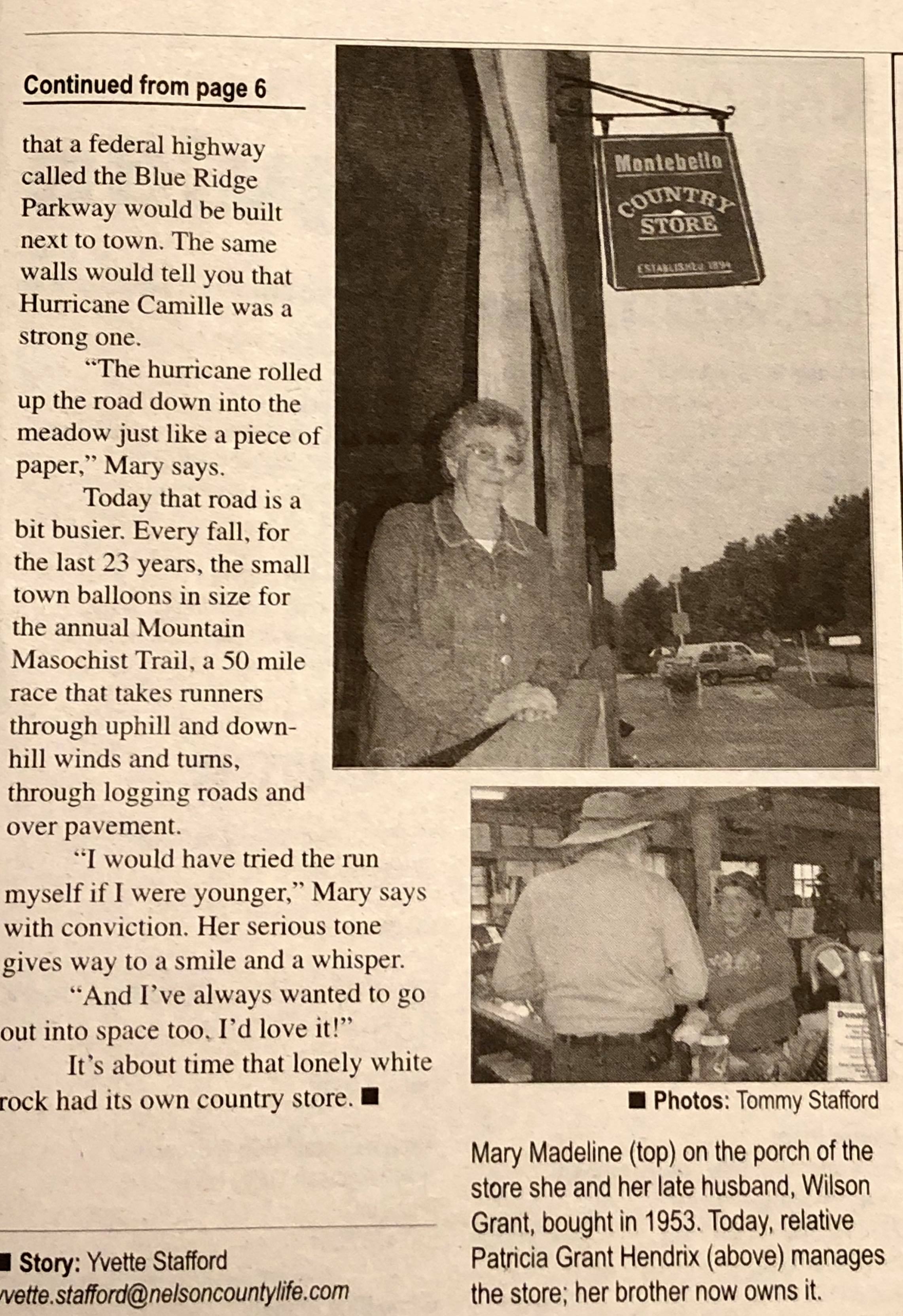
Copyright : Nelson County Life / Blue Ridge Life 2005-2019 : Mrs. Madeline Grant in our November 2005 cover story about the Montebello Country Story. Mrs. Grant passed away within the past day or so.
Montebello
Nelson County, Virginia
Back in the fall of 2005 just months after launching our charter magazine, Nelson County Life, we did a story on one of the most notable landmarks in Central Virginia not far off of the Blue Ridge Parkway. Montebello Country Store has been around for more than a century! Sadly, we learned about the passing of the store’s matriarch, Mrs. Madeline Grant. Though she retired back in the early 90s, Mrs. Grant was still a fixture at the store and would be seen there often in the following years.
Below, Montebello Camping & Fishing Resort made the announcement of Mrs. Grant’s passing on their Facebook page.
The cover from our November 2005 story about the Montebello Country Store and Mrs Grant.Copyright : Nelson County Life / Blue Ridge Life 2005-2019 : Mrs. Madeline Grant in our November 2005 cover story about the Montebello Country Store. Mrs. Grant passed away within the past day or so. Click on image above to enlarge and read.
The remainder of our story on Mrs. Grant in the November 2005 issue of then Nelson County Life Magazine long before we became Blue Ridge Life. Click on image above to enlarge and read.
RIP Mrs. Grant, we will miss you, along with thousands of others that got to know you over the decades. Our deepest thoughts and hugs to everyone at the country store.
At 3:55 p.m. Friday (Dec. 20), Virginia State Police Trooper J.P. Campbell responded to a crash involving a horse-drawn buggy in Buckingham County. The crash occurred on Route 60 near High School Road.
The buggy was traveling east on Route 60 when it was struck from the rear by an eastbound 2015 Chevrolet Silverado pickup.The buggy was equipped with flashing lights and a reflective triangle.
The driver of the Silverado, George M. Lee, 67, of Buckingham, Va., was not injured in the crash.
There was a Buckingham County family of six riding in the enclosed, two-horse buggy. John Yoder, 36, who was seated outside, was thrown from the buggy when it was struck. Four children – two boys and two girls ranging in age from 2 years to 10 years old were transported to UVA Medical Center for treatment of serious injuries. Sylvia Yoder, 31, was transported to UVA Medical Center and succumbed to her injuries Saturday morning (Dec. 21).
Lee was charged with reckless driving. Alcohol was not a factor in the crash, which remains under investigation.
One of the two horses had to be euthanized at the scene. The other horse was transported from the scene by a vet for treatment of injuries sustained in the crash.
Corinne N. Geller
Public Relations Director
Virginia State Police
For the absolute latest updates from NWS, click on the image above.
WINTER WEATHER ADVISORY
URGENT – WINTER WEATHER MESSAGE
NATIONAL WEATHER SERVICE BALTIMORE MD/WASHINGTON DC
941 PM EST THU DEC 12 2019
AUGUSTA-ROCKINGHAM-NELSON-ALBEMARLE-GREENE-WESTERN HIGHLAND-
EASTERN HIGHLAND-CENTRAL VIRGINIA BLUE RIDGE-WESTERN PENDLETON-
EASTERN PENDLETON-
941 PM EST THU DEC 12 2019
…WINTER WEATHER ADVISORY REMAINS IN EFFECT FROM 4 AM TO 3 PM
EST FRIDAY…
* WHAT…FREEZING RAIN EXPECTED. TOTAL ICE ACCUMULATIONS OF UP
TO ONE TENTH OF AN INCH.
* WHERE…PORTIONS OF THE POTOMAC HIGHLANDS IN WEST VIRGINIA AND
VIRGINIA, AND THE CENTRAL SHENANDOAH VALLEY OF VIRGINIA.
* WHEN…FROM 4 AM TO 3 PM EST FRIDAY.
* IMPACTS…VERY SLIPPERY SIDEWALKS, ROADS AND BRIDGES ARE
POSSIBLE. THE HAZARDOUS CONDITIONS COULD IMPACT THE MORNING
COMMUTE.
* ADDITIONAL DETAILS…FREEZING RAIN DURING THE MORNING WILL
GRADUALLY CHANGE TO RAIN THROUGHOUT THE AFTERNOON.
PRECAUTIONARY/PREPAREDNESS ACTIONS…
SLOW DOWN AND USE CAUTION WHILE TRAVELING.
WHEN VENTURING OUTSIDE, WATCH YOUR FIRST FEW STEPS TAKEN ON
STEPS, SIDEWALKS, AND DRIVEWAYS, WHICH COULD BE ICY AND SLIPPERY,
INCREASING YOUR RISK OF A FALL AND INJURY.
URGENT – WINTER WEATHER MESSAGE
National Weather Service Blacksburg VA
335 PM EST Thu Dec 12 2019
…Freezing rain is expected tonight into Friday morning…
Ashe-Alleghany NC-Surry-Stokes-Watauga-Wilkes-Yadkin-Tazewell-
Smyth-Bland-Giles-Wythe-Pulaski-Montgomery-Grayson-Carroll-Floyd-
Craig-Alleghany VA-Bath-Roanoke-Botetourt-Rockbridge-Patrick-
Franklin-Bedford-Amherst-Henry-Mercer-Summers-Monroe-
Eastern Greenbrier-Western Greenbrier-
Including the cities of West Jefferson, Sparta, Dobson, Danbury,
Boone, Wilkesboro, Yadkinville, Tazewell, Marion, Bland,
Pearisburg, Wytheville, Radford, Pulaski, Blacksburg,
Independence, Whitetop, Troutdale, Volney, Galax, Floyd,
New Castle, Clifton Forge, Covington, Hot Springs, Roanoke,
Salem, Fincastle, Lexington, Buena Vista, Stuart, Rocky Mount,
Amherst, Martinsville, Bluefield, Hinton, Hix, Union, Lewisburg,
White Sulphur Springs, Quinwood, Duo, and Rainelle
335 PM EST Thu Dec 12 2019
…WINTER WEATHER ADVISORY NOW IN EFFECT FROM MIDNIGHT TONIGHT TO
3 PM EST FRIDAY…
* WHAT…Freezing rain. Freezing rain will start with a brief mix
of sleet and snow. Total snow and sleet accumulations less than
one inch. Ice accumulations of up to two tenths of an inch.
Locally higher amounts are likely along the Blue Ridge.
* WHERE…The mountains and foothills of southwest Virginia,
northwest North Carolina and southeast West Virginia.
* WHEN…From midnight tonight to 3 PM EST Friday.
* IMPACTS…Travel will be hazardous. Isolated power outages and
tree damage. Bridges, overpasses, untreated roads and sidewalks,
and lesser used secondary roads will be slippery. The hazardous
conditions will impact the Friday morning commute.
PRECAUTIONARY/PREPAREDNESS ACTIONS…
Slow down and use extra caution while traveling. Prepare for
possible power outages.
The latest road conditions for the state you are calling from can
be obtained by calling 5 1 1.
Thanks to Scott Folsom for the photo : A cold rain was falling early Sunday morning down in the valley, but up top in the higher elevations ice was forming as temperatures hovered around the freezing mark. December 1, 2019
Devils Knob
Wintergreen Resort
Nelson County, Virginia
December started off with a cold rain for most people across the Blue Ridge, but if you are in the higher elevations ice has been forming on exposed surfaces like trees and railings. Scott Folsom sent us this photo Sunday morning. He tells us it’s, “Devils Knob near Summit Lane at 08:45.” Devils Knob is anywhere from 3200′ to nearly 4000′ depending on the location up there.
Around 7:25 am, Albemarle County Police Officers responded to a call of a male discovered trapped under an ATV off Parsons Green Lane in the Crozet area. Chad D. Ervin, 44 years old, of Charlottesville, was declared dead on-scene. The cause of the crash is not known at this time.
This is an ongoing investigation. No further information will be released at this time.
For several years during the infancy of Blue Ridge Life Magazine(back then Nelson County Life) Earl Hamner wrote poems and stories for us that we luckily got to include in the pages of the magazine. We remained dear friends with Earl until his death back in March of 2016.
One of our favorites Earl shared with us back in 2006 was his Thanksgiving Memory. We share it with you this Thanksgiving 2019.
A THANKSGIVING MEMORY
By
Earl Hamner
In the beginning Schuyler was a company town, the home of The Alberene Stone Corporation, which quarried and milled soapstone. We lived in company built houses and bought our goods from the company store. Schuyler had been a prosperous little village but when the Great Depression came the mill closed. My father found work in Waynesboro and could only be home with his family on holidays and weekends.
I remember a Thanksgiving from those years. Mornings were strangely quiet because the whistle calling the workers to the mill no longer sounded. On this Thanksgiving morning the sound that woke us was that of my father, home for the holiday, building a fire in the wood-burning cook stove. He drenched the wood with kerosene and when he lit it with a match the flames mad a whooshing sound as they roared up the chimney.
Shortly, he called down the hall to my mother, “Sweetheart,” which was his name for her till his dying day. My mother answered, “I’m on my way,” and joined him in the kitchen. They spoke quietly to each other, sharing private moments. Soon the sound of coffee percolating and the aroma of sizzling bacon would drift up to our rooms.
We descended upon them, eight red headed brothers and sisters, crowding around the stove to warm up. Breakfast was served at a long wooden trestle table my father had built and while we ate he would admire his brood and call us his “thoroughbreds.”
Each of us was assigned chores. The girls helped our mother wash and dry the dishes, make the beds, washing and iron the clothes. The boys tended to outside chores. There was the cow to be milked. She was a brown and white Guernsey. My father had bought her from Miss Dolly Hall for forty dollars. Miss Dolly had named her Chance because she gave a “good chance” of butter. The chickens had been up before us and were waiting for the grain we tossed to them on the frosty ground. Feeding the pigs was a melancholy chore. They had intelligent eyes and looked up trustingly as we poured slops into their tough. I knew, and it pained me, but they were unaware that they did not have long to live.
Our Father had brought home the turkey the day before. He had shot it over on Wales Mountain and my mother was already preparing it for the oven when company began to arrive.
We were part of two great clans. In addition to my mother’s family, most of whom lived close by, my father’s people, aunts and uncles and cousins would arrive from Richmond and Petersburg. We were in awe of the city cousins. They used slang words that were new to us such as “guy” “jerk” or “kiddo” which made us feel naïve and countrified. We children would travel in packs, playing the old games of Hide and Go Seek, Olly, Olly Oxen Free, and in the nearby school yard we would shoot baskets or play baseball, or find a plowed fiend where we searched for arrowheads and fools gold.
At home the conversation grew in pitch and volume as everybody talked at once. Hardly anybody heard what the other was saying but everybody knew what was going on. We are a family of story tellers. No event is without significance to us, and all that happens becomes a part of our history. We keep and share every detail. Our reunions become a verbal history of birth and death, of failures and accomplishments, of hardships and good times and just celebrating the joy of being together again. Being an aspiring writer I kept notes!
At one point everybody piled into cars and went to the graveyard where we paid respects to our dead. The more recent graves were marked by stones with names and dates carved or engraved on them. In the older section we came to earlier graves marked simply by a single primitive stone with no lettering to tell the name of who rested beneath it.
On the way home one of the uncles made a detour down to Esmont to visit the Staples Sisters who made bootleg apple brandy. He brought a bottle back with him and it was surreptitiously passed from one of the uncles to the other. If she caught sight of it one of the wives would disapprove but her scolding did not last long for someone moved to the piano and soon all the grown ups had their arms around each other, swaying back and forth while singing “In the Garden” or “Down by The Old Mill Stream” or “Let Me Call You Sweetheart.”
In the late afternoon dinner was served. If my grandmother was there she would say a proper grace, but if she was not my father said, “Look out, Lord, we’re gonna eat!” What a feast ensued! The turkey, golden brown, had a minimum of birdshot left in it. The applesauce was made from fruit we had gathered from an abandoned orchard down on Mt. Alto. The butter beans, the corn, and the peas came come from our summer garden and canned by my mother. The potatoes flavored with Chance’s rich butter were not mashed but creamed. Finally desserts. The sweet potato pie, still warm from the oven, was encased in a crust so crumbly and sweet that it alone could have been a dessert. And then came the pumpkin pie, steaming aromas of brown sugar and nutmeg, and all laced with generous portions of whipped cream. All of it was accompanied by milk for the children, coffee for the adults and if requested iced tea as sweet as sugar cane.
At sundown out-of-town guests drifted off to whatever relative had taken them in for the night. Others, sated with food and companionship, gathered around the radio for Franklin D. Roosevelt’s Thanksgiving message. Sleepy, exhausted children were carted off to bed. It was a family custom that we would call goodnight to each other from room to room and finally, we would drowse off to sleep secure in the knowledge that we were home, safe and loved.
They were challenging times, those Depression Years. They seem so distant now. We thought we were poor, but in them we were richer than we knew.
The house where we lived is quiet now. No one lives there any more except for a family of dirt daubers and ghosts that move from room to room behind the empty windows.
In memory I go there each night. I stand beside the gate, look up to the house, and once again I hear the voices of my mother and father, my brothers and sisters as we call goodnight to each before we rest.
For absolute latest updates from NWS click on image above.
Central Virginia Blue Ridge-
Including the city of Wintergreen
337 PM EST Wed Nov 27 2019

...WIND ADVISORY IN EFFECT UNTIL 6 PM EST THIS EVENING...
...HIGH WIND WARNING IN EFFECT UNTIL 1 PM EST THURSDAY...

TONIGHT...Mostly clear and windy. Lows in the upper 30s. West
winds 20 to 30 mph with gusts up to 60 mph.
.THANKSGIVING DAY...Sunny, breezy with highs in the mid 40s.
Northwest winds 15 to 25 mph. Gusts up to 60 mph, decreasing to
35 mph in the afternoon.
.THURSDAY NIGHT...Mostly clear in the evening, then becoming
mostly cloudy. Lows in the lower 30s. Northwest winds 10 to
15 mph with gusts up to 25 mph.
URGENT - WEATHER MESSAGE
National Weather Service Blacksburg VA
236 PM EST Wed Nov 27 2019

Ashe-Alleghany NC-Watauga-Tazewell-Smyth-Bland-Giles-Wythe-
Pulaski-Montgomery-Grayson-Carroll-Floyd-Craig-Alleghany VA-Bath-
Roanoke-Botetourt-Rockbridge-Amherst-Western Greenbrier-
Including the cities of West Jefferson, Sparta, Boone, Tazewell,
Marion, Bland, Pearisburg, Wytheville, Radford, Pulaski,
Blacksburg, Independence, Whitetop, Troutdale, Volney, Galax,
Floyd, New Castle, Clifton Forge, Covington, Hot Springs,
Roanoke, Salem, Fincastle, Lexington, Buena Vista, Amherst,
Quinwood, Duo, and Rainelle
236 PM EST Wed Nov 27 2019

...HIGH WIND WARNING REMAINS IN EFFECT UNTIL 1 PM EST THURSDAY...

* WHAT...West winds 15 to 30 mph with gusts 55 to 60 mph
  possible.

* WHERE...Tazewell, Smyth, Bland, Giles, Wythe, Pulaski,
  Montgomery, Craig and Alleghany VA Counties.

* WHEN...Until 1 PM EST Thursday.

* IMPACTS...Damaging winds could blow down trees and power
  lines. Widespread power outages are possible. Travel could be
  difficult, especially for high profile vehicles on north to
  south roadways.

PRECAUTIONARY/PREPAREDNESS ACTIONS...

People should avoid being outside in forested areas and around
trees and branches. If possible, remain in the lower levels of
your home during the windstorm, and avoid windows. Use caution if
you must drive.
URGENT - WEATHER MESSAGE National Weather Service Baltimore MD/Washington DC 156 PM EST Wed Nov 27 2019 Augusta-Rockingham-Western Highland-Eastern Highland- Northern Virginia Blue Ridge-Central Virginia Blue Ridge- Western Pendleton-Eastern Pendleton- Including the cities of Staunton, Waynesboro, Stuarts Draft, Harrisonburg, Hightown, Monterey, Big Meadows, Wintergreen, Riverton, Brandywine, Franklin, Oak Flat, Ruddle, and Sugar Grove 156 PM EST Wed Nov 27 2019 ...WIND ADVISORY REMAINS IN EFFECT UNTIL 6 PM EST THIS EVENING... ...HIGH WIND WARNING REMAINS IN EFFECT FROM 6 PM THIS EVENING TO 1 PM EST THURSDAY... * WHAT...For the High Wind Warning, west to northwest winds 25 to 35 mph with gusts around 60 mph expected. For the Wind Advisory, southwest winds 20 to 30 mph with around 50 mph expected. * WHERE...In Virginia, Augusta, Rockingham, Western Highland and Eastern Highland Counties, and Northern Virginia Blue Ridge and Central Virginia Blue Ridge. In West Virginia, Western Pendleton and Eastern Pendleton Counties. * WHEN...For the High Wind Warning, from 6 PM this evening to 1 PM EST Thursday. For the Wind Advisory, through 6 PM this evening. * IMPACTS...Damaging winds will blow down trees and power lines. Widespread power outages are expected. Travel will be difficult, especially for high profile vehicles. PRECAUTIONARY/PREPAREDNESS ACTIONS... People should avoid being outside in forested areas and around trees and branches. If possible, remain in the lower levels of your home during the windstorm, and avoid windows. Use caution if you must drive.
URGENT – WEATHER MESSAGE
National Weather Service Baltimore MD/Washington DC
916 PM EST Tue Nov 26 2019
Augusta-Rockingham-Northern Virginia Blue Ridge-
Central Virginia Blue Ridge-
Including the cities of Staunton, Waynesboro, Stuarts Draft,
Harrisonburg, Big Meadows, and Wintergreen
916 PM EST Tue Nov 26 2019
…WIND ADVISORY REMAINS IN EFFECT FROM 10 AM TO 6 PM EST
WEDNESDAY…
…HIGH WIND WATCH REMAINS IN EFFECT FROM WEDNESDAY EVENING
THROUGH THURSDAY AFTERNOON…
* WHAT…For the Wind Advisory, southwest winds 20 to 35 mph
with gusts around 50 mph expected for elevations above 2500
feet. For the High Wind Watch, winds west to northwest 25 to
35 mph with the potential for gusts around 60 mph.
* WHERE…Augusta and Rockingham Counties, and Northern Virginia
Blue Ridge and Central Virginia Blue Ridge.
* WHEN…For the Wind Advisory, from 10 AM to 6 PM EST
Wednesday. For the High Wind Watch, from Wednesday evening
through midday Thursday.
* IMPACTS…Damaging winds could blow down trees and power
lines. Widespread power outages are possible. Travel could be
difficult, especially for high profile vehicles.
PRECAUTIONARY/PREPAREDNESS ACTIONS…
Monitor the latest forecasts and warnings for updates on this
situation. Fasten loose objects or shelter objects in a safe
location prior to the onset of winds.
URGENT – WEATHER MESSAGE
National Weather Service Blacksburg VA
244 PM EST Tue Nov 26 2019
Ashe-Alleghany NC-Surry-Watauga-Wilkes-Wythe-Pulaski-Montgomery-
Grayson-Carroll-Floyd-Craig-Alleghany VA-Bath-Roanoke-Botetourt-
Rockbridge-Patrick-Franklin-Bedford-Amherst-Eastern Greenbrier-
Western Greenbrier-
Including the cities of West Jefferson, Sparta, Dobson, Boone,
Wilkesboro, Wytheville, Radford, Pulaski, Blacksburg,
Independence, Whitetop, Troutdale, Volney, Galax, Floyd,
New Castle, Clifton Forge, Covington, Hot Springs, Roanoke,
Salem, Fincastle, Lexington, Buena Vista, Stuart, Rocky Mount,
Bedford, Amherst, Lewisburg, White Sulphur Springs, Alderson,
Quinwood, Duo, and Rainelle
244 PM EST Tue Nov 26 2019
…HIGH WIND WATCH IN EFFECT FROM WEDNESDAY AFTERNOON THROUGH
THURSDAY AFTERNOON…
* WHAT…West winds 20 to 30 mph with gusts up to 65 mph
possible.
* WHERE…Portions of central, south central, southwest and west
central Virginia, north central and northwest North Carolina
and southeast West Virginia.
* WHEN…From Wednesday afternoon through Thursday afternoon.
* IMPACTS…Damaging winds could blow down trees and power
lines. Widespread power outages are possible. Travel could be
difficult, especially for high profile vehicles.
PRECAUTIONARY/PREPAREDNESS ACTIONS…
Monitor the latest forecasts and warnings for updates on this
situation. Fasten loose objects or shelter objects in a safe
location prior to the onset of winds.
Photo via Charlottesville Triathlon Club, David Lonnquest and Nelson Cycling. Mark Robbins (above) body was recovered Tuesday afternoon in Albermarle County.
South Fork Rivanna Reservoir
Albemarle County, Virginia
This is an update to a story we first posted on our BRL Facebook Page back on November 21st. Sadly the update this Tuesday evening is not good news. Below is the verbatim press release from ACPD.
At approximately 3:00 pm this afternoon, Albemarle County Police Officers and Fire Rescue personnel responded to a report of an unusual object in the South Fork Rivanna Reservoir in the vicinity of Lochridge Lane. The Underwater Recovery Team recovered a body at approximately 5:20 pm and were able to identify the man as Mark Kenneth Robbins. A cause of death determination will be made by the Medical Examiners Office in Richmond.
Mr. Robbins, 58 years old, of Charlottesville, had been missing since November 17.
This remains an active investigation. No further information will be released at this time.


")


 CANCELED")

 Wind Advisories & High Wind Watch – CANCELED")


