Graphic vis NWS Blacksburg : There is an increased fire danger today across part of the Blue Ridge. Sunday – March 27, 2022
Elevated Fire Weather Conditions This Afternoon
Special Weather Statement
National Weather Service Blacksburg VA
553 AM EDT Sun Mar 27 2022

Grayson-Carroll-Floyd-Patrick-Franklin-Bedford-Amherst-Henry-
Pittsylvania-Campbell-Appomattox-Buckingham-Halifax-Charlotte-
Including the cities of Independence, Whitetop, Troutdale,
Volney, Galax, Floyd, Stuart, Rocky Mount, Bedford, Amherst,
Martinsville, Danville, Lynchburg, Appomattox, South Boston,
and Keysville
553 AM EDT Sun Mar 27 2022


...Elevated Fire Weather Conditions This Afternoon...

A combination of dry and breezy conditions will create an
enhanced risk for the active spread of wildfires this afternoon.

West-northwest winds 10 to 20 mph, with gusts of 25 to 30 mph
will occur today. Humidity levels will fall to 20 to 25 percent
in the afternoon. This will result in elevated fire weather
conditions that would support rapid rates of spread for wildland
fires.

Residents are urged to exercise caution handling any potential
ignition source...including machinery... cigarettes...and matches.
Be sure to properly discard all smoking materials. Any dry
grasses and tree litter that ignite will have the potential to
spread quickly.
Photos By John Taylor up on Devils Knob at Wintergreen Resort : The calendar may say it’s officially spring, but winter returned Saturday morning in the mountains of Nelson County. March 26, 2022
Wintergreen
Devils Knob
Nelson County, Virginia
The calendar says we officially changed to spring last weekend, but winter still has a trick or two left in the bag. Folks living up in the higher elevations were greeted by some light snow and gusty winds Saturday morning around daylight. John Taylor up on Devils Knob (3500′) at Wintergreen Resort sent us these photos of what John’s calling a “very heavy dusting.”
It’s not unusual to see snow in the Blue Ridge Mountains in March or even into April. But, it will become less and less of a threat as the shift from winter to spring continues in the coming weeks.
This weekend will continue to be very chilly, especially in the higher elevations. Milder temps return to the area by the middle of next week.
Via NWS Blacksburg : A significant portion of our area is in an increased risk for wildfires this Sunday afternoon – March 20, 2022. Click image above for latest from NWS.
INCREASED FIRE DANGER THIS AFTERNOON
Special Weather Statement
National Weather Service Blacksburg VA
1036 AM EDT Sun Mar 20 2022

Ashe-Alleghany NC-Surry-Stokes-Rockingham-Caswell-Watauga-Wilkes-
Yadkin-Smyth-Wythe-Pulaski-Montgomery-Grayson-Carroll-Floyd-
Roanoke-Botetourt-Rockbridge-Patrick-Franklin-Bedford-Amherst-
Henry-Pittsylvania-Campbell-Appomattox-Buckingham-Halifax-
Charlotte-
Including the cities of West Jefferson, Sparta, Dobson, Danbury,
Eden, Yanceyville, Boone, Wilkesboro, Yadkinville, Marion,
Wytheville, Radford, Pulaski, Blacksburg, Independence, Whitetop,
Troutdale, Volney, Galax, Floyd, Roanoke, Salem, Fincastle,
Lexington, Buena Vista, Stuart, Rocky Mount, Bedford, Amherst,
Martinsville, Danville, Lynchburg, Appomattox, South Boston,
and Keysville
1036 AM EDT Sun Mar 20 2022

...INCREASED FIRE DANGER THIS AFTERNOON FOR SOUTHWEST VIRGINIA
AND NORTHWEST NORTH CAROLINA...

Winds will gust from the northwest at 20 to 30 mph this afternoon.
Humidity levels drop below 35 percent in the mountains and below
25 percent in the foothills and piedmont. These winds and low
relative humidity values will create an increased fire danger this
afternoon through around sunset. Wind speeds will decrease around
sunset.

Outdoor burning is discouraged. Please refer to your local burn
permitting authorities on whether you can burn. Use caution with
any potential ignition sources such as campfires and cigarettes.
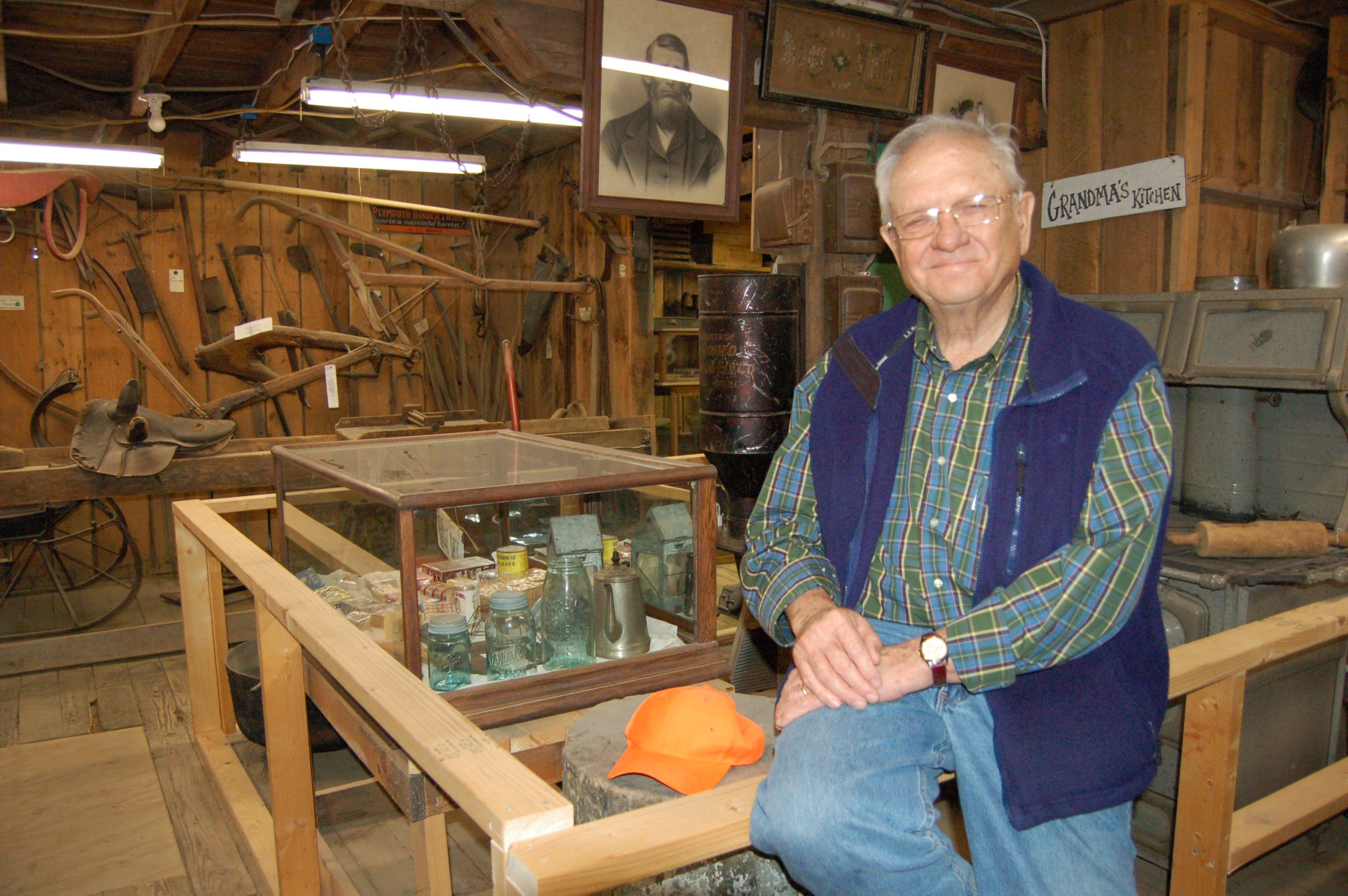
Photo By Tommy Stafford : Mr Paul Saunders seen here in this photo from 2006 in his farm museum located at the Saunders Brother Farm Market. Mr. Saunders passed away Friday, March 11, 2022
Piney River
Nelson County, Virginia
By Tommy Stafford
I knew the day would eventually come. I’d have to write this very story about the passing of the legendary Paul Saunders, Sr. What I know about Paul is just a tiny bit the native Nelsonians living here for generations already know. Mr. Paul, as I would call him, has so much history it’s hard to even know where to start. It’s safe to say that he and his family’s impact on the county predates a lot of us. (You can read the history of the Saunders family here from their webpage – at the bottom) So, I’m not going to go down the road of his personal history. It’s been written about often, even in the pages of our print magazine from years ago.
I am simply writing about the man Yvette and I came to know shortly after moving from Tennessee to Nelson County back in 2004. We met Mr. Paul and quickly became friends with many of his sons, grandchildren, wives, and more. Our friend, the late Steve Crandall initially introduced us and said, “You’ve got to meet all of these Saunders, they are an amazing family.” Steve was right. One of Mr. Paul’s sons, Tom, spent two hunting seasons teaching Yvette how to deer and turkey hunt. Something she still does every single year.
Probably one of the biggest compliments one could ever be given is when Mr. Paul asked Yvette to write the back cover to his Heartbeats of Nelson book released not long after we founded then Nelson County Life Magazine in 2005.
Mr. Paul back in April 2007 signing Yvette’s copy of Heartbeats of Nelson after a presentation at The Nature Foundation at Wintergreen.The back cover of Mr. Paul’s first book, Heartbeats of Nelson. Click on photo above to enlarge and read.
Mr. Paul would go on to write another book years later called, Down on the Farm.
If there was ever a man that loved Nelson County, it was Paul Saunders. He would often be seen at the Saunders Brothers Farm Market each season walking around and greeting people passing through. Anytime he’d see us in there with Adam or Peyton as little kids he’d stop us and say, “Come here, let me get those children a scoop of ice cream.” He’d never let us pay him. I don’t know how many scoops they had over the years, but more than I could count!
Above a video that was recently produced for Saunders about their legacy. It was actually done before Mr. Paul’s passing, but timely and the end reedited in light of his passing.
Mr. Paul pushing a cart of fruit at the Saunders Brothers Farm Market back in 2007. He loved each and every season when the market would get into full swing.
Over the years we got to know Mr. Paul and all of his family even more. They’d often invite us to get togethers and such, just to make us “come heres” feel welcome and a part of the Nelson he loved so much.
I don’t remember the last exact time I saw Mr. Paul in person. It might have been a few years ago when we went to his son Tom’s house and had supper while a football game was on TV. I just remember him as always being a man that was inclusive and kind. And, truly loving his family, and what he did.
Mr. Paul checking out peaches in one of his many orchards back in 2006.
To read Mr. Paul Saunders, Sr. complete obit and arrangements click on the photo above for more from Wells/Sheffield Funeral Chapel. A visitation will also be held for friends and family at Saunders Brothers Farm Market Wednesday March 16th, 2022 4:00pm – 7:00pm 2717 Tye Brook Highway Piney River , VA 22964
I’ll end this post with something Mr. Paul told me in an interview we did with him back in November 2006 as he was getting Heartbeats of Nelson ready to eventually distribute. It pretty much sums up how this great man felt about the county, and the people he loved so much.
“We think the almighty for making a place like Nelson County. The beauty we have here and the people we have here. It’s just been a blessing for people who have raised families here. It’s been a good life…it’s been a good life. You don’t have to go a hundred miles to have a good life, you’ve got it right here. Why run away from it.” Paul Saunders – November 2006
A good life indeed Mr. Paul. Well done. Now take a well much deserved rest. We’ll see you on the other side.
Photo By BRL Mountain Photographer Paul Purpura : Around 2-3 inches of snow fell early Saturday morning – March 12, 2022 – at Wintergreen Resort. This photo is at Three Ridges just above the Mountain Inn.
While areas to the east of the Blue Ridge Parkway down below had only light amounts of snowfall by late Saturday morning, Wintergreen Resort up around 2500 feet had about 2-3 inches of snow by 10 AM.
Via NWS : A Blizzard Warning is in effect for much of Saturday along the Blue Ridge Parkway & Skyline Drive. This includes Wintergreen and Big Meadows. This warning upgrades from the previously issued Winter Storm Warning earlier.
This replaces the earlier issued Winter Storm Warning
BLIZZARD WARNING
URGENT – WINTER WEATHER MESSAGE
National Weather Service Baltimore MD/Washington DC
910 PM EST Fri Mar 11 2022
Central Virginia Blue Ridge – Including The Blue Ridge Parkway & Wintergreen
910 PM EST Fri Mar 11 2022
…BLIZZARD WARNING IN EFFECT FROM 3 AM TO 3 PM EST SATURDAY…
* WHAT…Blizzard conditions expected. Total snow accumulations of
3 to 6 inches. Winds gusting as high as 55 mph.
* WHERE…Central Virginia Blue Ridge.
* WHEN…From 3 AM to 3 PM EST Saturday.
* IMPACTS…Travel could be very difficult to impossible. Strong
winds combined with heavy wet snow will cause tree damage.
* ADDITIONAL DETAILS…The combination of snow and blowing snow
will reduce visibility below one-quarter mile. Blizzard
conditions are most likely between 7 AM and Noon.
PRECAUTIONARY/PREPAREDNESS ACTIONS…
Travel should be restricted to emergencies only. If you must
travel, have a winter survival kit with you. If you get stranded,
stay with your vehicle.
When venturing outside, watch your first few steps taken on
steps, sidewalks, and driveways, which could be icy and slippery,
increasing your risk of a fall and injury.
URGENT – WINTER WEATHER MESSAGE
National Weather Service Baltimore MD/Washington DC
910 PM EST Fri Mar 11 2022
Northern Virginia Blue Ridge – (Including Skyline Drive & Big Meadows)
910 PM EST Fri Mar 11 2022
…BLIZZARD WARNING IN EFFECT FROM 3 AM TO 3 PM EST SATURDAY…
* WHAT…Blizzard conditions expected. Total snow accumulations of
5 to 10 inches. Winds gusting as high as 55 mph.
* WHERE…Northern Virginia Blue Ridge.
* WHEN…From 3 AM to 3 PM EST Saturday.
* IMPACTS…Travel could be very difficult to impossible. Strong
winds combined with heavy wet snow will cause tree damage.
* ADDITIONAL DETAILS…The combination of snow and blowing snow
will reduce visibility below one-quarter mile. Blizzard
conditions are most likely between 7 AM and Noon.
PRECAUTIONARY/PREPAREDNESS ACTIONS…
Travel should be restricted to emergencies only. If you must
travel, have a winter survival kit with you. If you get stranded,
stay with your vehicle.
When venturing outside, watch your first few steps taken on
steps, sidewalks, and driveways, which could be icy and slippery,
increasing your risk of a fall and injury.
Via NWS : A Winter Storm Warning is in effect Saturday for the Skyline Drive area. Winter Weather Advisories are in effect for lowlands and other areas. For the absolute latest updates click here for our weather alerts page.
Earlier post below, now replaced. WINTER STORM WARNING
URGENT – WINTER WEATHER MESSAGE
National Weather Service Baltimore MD/Washington DC
357 AM EST Fri Mar 11 2022
Northern Virginia Blue Ridge – Including Big Meadows
357 AM EST Fri Mar 11 2022
…WINTER STORM WARNING IN EFFECT FROM 3 AM TO 3 PM EST
SATURDAY…
* WHAT…Heavy snow expected. Total snow accumulations of 3 to 6
inches. Northwest winds will gust around 45 to 55 mph.
* WHERE…Northern Virginia Blue Ridge.
* WHEN…From 3 AM to 3 PM EST Saturday. Rain will change to snow
between 3 and 5 AM early Saturday. The steadiest snow will be
through Saturday morning.
* IMPACTS…Travel could be very difficult. Gusty winds could
bring down tree branches.
* ADDITIONAL DETAILS…The combination of snow and blowing snow
may reduce visibility below one-half mile at time. Near blizzard
conditions are possible.
PRECAUTIONARY/PREPAREDNESS ACTIONS…
If you must travel, keep an extra flashlight, food, and water in
your vehicle in case of an emergency.
When venturing outside, watch your first few steps taken on
steps, sidewalks, and driveways, which could be icy and slippery,
increasing your risk of a fall and injury.
WINTER WEATHER ADVISORY
URGENT – WINTER WEATHER MESSAGE
National Weather Service Baltimore MD/Washington DC
357 AM EST Fri Mar 11 2022
Augusta-Rockingham-Central Virginia Blue Ridge – (Including Wintergreen Resort)
357 AM EST Fri Mar 11 2022
…WINTER WEATHER ADVISORY IN EFFECT FROM 3 AM TO 1 PM EST
SATURDAY…
* WHAT…Snow expected. Total snow accumulations of 1 to 3 inches,
with localized amounts around 3 to 5 inches above 2000 feet.
Northwest winds will gust around 45 to 55 mph, especially over
the ridges.
* WHERE…Augusta and Rockingham Counties, and Central Virginia
Blue Ridge.
* WHEN…From 3 AM to 1 PM EST Saturday. Rain will change to snow
between 2 and 5 AM early Saturday morning. The steadiest snow
will be Saturday morning.
* IMPACTS…Plan on slippery road conditions.
* ADDITIONAL DETAILS…Visibility may be reduced to below one-
half mile at times.
PRECAUTIONARY/PREPAREDNESS ACTIONS…
Slow down and use caution while traveling.
When venturing outside, watch your first few steps taken on
steps, sidewalks, and driveways, which could be icy and slippery,
increasing your risk of a fall and injury.
WINTER WEATHER ADVISORY
URGENT – WINTER WEATHER MESSAGE
National Weather Service Blacksburg VA
339 AM EST Fri Mar 11 2022
Craig-Alleghany VA-Rockbridge-Amherst-
Including the cities of New Castle, Clifton Forge, Covington, Lexington, Buena Vista, and Amherst
339 AM EST Fri Mar 11 2022
…WINTER WEATHER ADVISORY IN EFFECT FROM 3 AM TO 1 PM EST
SATURDAY…
* WHAT…Snow expected. Total snow accumulations of up to two
inches. Winds gusting as high as 35 mph.
* WHERE…Craig, Alleghany VA, Rockbridge and Amherst Counties.
* WHEN…From 3 AM to 1 PM EST Saturday.
* IMPACTS…Plan on slippery road conditions.
* ADDITIONAL DETAILS…The wind and snow may bring limited
visibilities.
PRECAUTIONARY/PREPAREDNESS ACTIONS…
A Winter Weather Advisory for snow means that periods of snow
will cause travel difficulties. Be prepared for snow covered
roads and limited visibilities…and use caution while driving.
Please report snow and sleet accumulations via email at
rnk.skywarn@noaa.gov or by calling the National Weather Service
toll free at…1…866…2 1 5…4 3 2 4. Leave a message with
your observation and the specific location where it occurred. You
can also post your report to National Weather Service Blacksburg
Facebook page and on Twitter.
The latest road conditions for the state you are calling from can
be obtained by calling 5 1 1.
Daylight Saving Time begins at 2 AM this Sunday morning, so be sure to set your clock ahead 1 hour at bedtime Saturday night.
Central Virginia Blue Ridge
With a few warmer days here and there thoughts are turning to longer days. Daylight Saving Time begins this Sunday – March 13th at 2AM.
If you don’t party until that hour, your best bet is to move your clock ahead one hour before turning in on Saturday night. Then you’re all taken care of until when we go back to standard time on Sunday November 6, 2022.
Until then, enjoy those longer, carefree days of summer soon to come!!
The scene this morning o I-81 SB as seen from a VDOT camera. Tuesday – March 9, 2022
Update from VDOT 4:15 PM
I-81 SOUTHBOUND REOPENS IN ROCKBRIDGE COUNTY
STAUNTON – (4:15 p.m.) Both Interstate 81 southbound lanes have reopened in Rockbridge County following cleanup from a multi-vehicle crash near mile marker 198. The incident involved several tractor trailers and other vehicles shortly after 6 a.m. today (Wednesday, March 9). Southbound I-81 reopened about 4 p.m.
(Earlier posts below)
As of 11:30 AM the SB lanes are still closed due to cleanup. Traffic backups are about 8 miles. Traffic is being alternately routed to Exit 200, Route 710, US 11 SB and back onto I-81 at exit 195.
From VDOT 7AM
Both southbound lanes of Interstate 81 are closed in Rockbridge County due to a crash involving multiple tractor trailers and other vehicles. The crash was reported shortly after 6 this morning (Wednesday, March 9) near mile marker 198. This location is between exit 200 at Fairfield and exit 195 at Lexington.
The Virginia Department of Transportation advises motorists to avoid this area. Southbound I-81 traffic can divert onto Route 11 (Lee Highway) at either exit 200 at Fairfield or exit 205 at Raphine. Motorists can re-enter southbound I-81 at exit 195.
For updated traffic alerts and travel information, dial 511 or go to http://www.511Virginia.org. The VDOT Customer Service Center can assist with reporting road hazards, asking transportation questions, or getting information related to Virginia’s roads. Call 800-FOR- ROAD (800-367-7623) or use its mobile friendly website at https://my.vdot.virginia.gov/. Agents are available 24 hours-a-day, seven days a week.
The Staunton District Twitter feed is at @VaDOTStaunton. Follow VDOT on Facebook, Flickr, Twitter and YouTube. RSS feeds are also available for statewide information. The VDOT Web page is located at http://www.VirginiaDOT.org.
The VDOT Staunton District serves Frederick, Shenandoah, Clarke, Warren, Page, Rockingham, Augusta, Highland, Rockbridge, Alleghany and Bath counties.
Via NWS : A Winter Weather Advisory is in effect (in purple) for areas along the Blue Ridge Parkway and Skyline Drive. This includes, Wintergreen, Montebello, Humpback Rocks, Afton Mountain, and Big Meadows. For the absolute latest updates visit our weather alerts page by clicking here.
WINTER WEATHER ADVISORY Including Wintergreen Resort (see forecast below)
URGENT - WINTER WEATHER MESSAGE
National Weather Service Baltimore MD/Washington DC
637 PM EST Tue Mar 8 2022

Northern Virginia Blue Ridge-Central Virginia Blue Ridge-
637 PM EST Tue Mar 8 2022

...WINTER WEATHER ADVISORY IN EFFECT FROM 1 AM TO 1 PM EST
WEDNESDAY...

* WHAT...Snow and freezing rain expected. Total snow
  accumulations of 1 to 2 inches and ice accumulations of up to
  one tenth of an inch.

* WHERE...Northern Virginia Blue Ridge and Central Virginia Blue
  Ridge.

* WHEN...From 1 AM to 1 PM EST Wednesday.

* IMPACTS...Plan on slippery road conditions. The hazardous
  conditions will impact the morning commute.

PRECAUTIONARY/PREPAREDNESS ACTIONS...

Slow down and use caution while traveling.

When venturing outside, watch your first few steps taken on
steps, sidewalks, and driveways, which could be icy and slippery,
increasing your risk of a fall and injury.
Zone Forecast Product
National Weather Service Baltimore MD/Washington DC
639 PM EST Tue Mar 8 2022
Central Virginia Blue Ridge-
Including the city of Wintergreen
639 PM EST Tue Mar 8 2022
…WINTER WEATHER ADVISORY IN EFFECT FROM 1 AM TO 1 PM EST
WEDNESDAY…
.TONIGHT…A chance of rain this evening, then rain, freezing
rain with a slight chance of snow after midnight. Snow
accumulation up to 1 inch. Ice accumulation of up to a tenth of
an inch. Lows in the lower 30s. Southeast winds 10 to 15 mph.
Chance of precipitation near 100 percent.
.WEDNESDAY…Rain and freezing rain, mainly in the morning. Ice
accumulation of up to a tenth of an inch. Highs around 40.
Southeast winds 10 to 15 mph, becoming northwest 5 to 10 mph in
the afternoon. Chance of precipitation near 100 percent.
.WEDNESDAY NIGHT…Mostly cloudy. Lows in the lower 30s. North
winds 10 to 15 mph.
.THURSDAY…Partly sunny. Highs in the upper 40s. Northeast winds
5 to 10 mph, becoming east in the afternoon.
.THURSDAY NIGHT…Partly cloudy. Lows in the mid 30s. Southeast
winds 5 to 10 mph, becoming south after midnight.
.FRIDAY…Mostly sunny. Highs in the mid 50s.
.FRIDAY NIGHT…Rain. Lows in the lower 30s. Chance of rain
80 percent.
.SATURDAY…Partly sunny with a chance of rain. Breezy with highs
in the upper 30s. Temperature falling into the upper 20s in the
afternoon. Chance of rain 50 percent.
.SATURDAY NIGHT…Mostly clear and blustery, cold with lows 15 to
20.
.SUNDAY…Sunny. Highs in the lower 40s.
.SUNDAY NIGHT…Mostly clear. Lows around 30.
.MONDAY…Mostly sunny. Highs in the mid 50s.
.MONDAY NIGHT…Partly cloudy. Lows in the upper 30s.
.TUESDAY…Mostly sunny. Highs in the upper 50s.
")

 Spring>Winter>Spring>Winter>Spring : Winter Reboots In The Blue Ridge" title="Winter>Spring>Winter>Spring>Winter>Spring : Winter Reboots In The Blue Ridge" />


")

")


")

")


")

