Home Blog Page 311

TORNADO WATCH: ! Canceled – Canceled !

0
Via NWS: A New Tornado Watch has been issued for Nelson County, Wintergreen and most of Central Virginia (highllighted in red above) until 2AM EDT. For the latest updates look to your right under Nelson Weather Alerts and be sure to refresh your browser often.

! CANCELED – CANCELED – CANCELED!

THIS WATCH HAS BEEN REPLACED WITH A NEW WATCH #247 UNTIL 8 AM EDT ON APRIL 28TH, 2011

URGENT – IMMEDIATE BROADCAST REQUESTED
TORNADO WATCH NUMBER 240
NWS STORM PREDICTION CENTER NORMAN OK
615 PM EDT WED APR 27 2011

SCROLL DOWN FOR COUNTY AND CITY OUTLINE AREAS

THE NWS STORM PREDICTION CENTER HAS ISSUED A
TORNADO WATCH FOR PORTIONS OF

DISTRICT OF COLUMBIA
MARYLAND
NORTHERN NORTH CAROLINA
CENTRAL AND EASTERN VIRGINIA
EASTERN WEST VIRGINIA
COASTAL WATERS

EFFECTIVE THIS WEDNESDAY NIGHT AND THURSDAY MORNING FROM 615 PM
UNTIL 200 AM EDT.

TORNADOES…HAIL TO 2 INCHES IN DIAMETER…THUNDERSTORM WIND
GUSTS TO 70 MPH…AND DANGEROUS LIGHTNING ARE POSSIBLE IN THESE
AREAS.

THE TORNADO WATCH AREA IS APPROXIMATELY ALONG AND 70 STATUTE
MILES EAST AND WEST OF A LINE FROM 15 MILES NORTHEAST OF
MARTINSBURG WEST VIRGINIA TO 30 MILES WEST SOUTHWEST OF RALEIGH
NORTH CAROLINA. FOR A COMPLETE DEPICTION OF THE WATCH SEE THE
ASSOCIATED WATCH OUTLINE UPDATE (WOUS64 KWNS WOU0).

REMEMBER…A TORNADO WATCH MEANS CONDITIONS ARE FAVORABLE FOR
TORNADOES AND SEVERE THUNDERSTORMS IN AND CLOSE TO THE WATCH
AREA. PERSONS IN THESE AREAS SHOULD BE ON THE LOOKOUT FOR
THREATENING WEATHER CONDITIONS AND LISTEN FOR LATER STATEMENTS
AND POSSIBLE WARNINGS.

OTHER WATCH INFORMATION…THIS TORNADO WATCH REPLACES TORNADO
WATCH NUMBER 233. WATCH NUMBER 233 WILL NOT BE IN EFFECT AFTER
615 PM EDT. CONTINUE…WW 232…WW 234…WW 235…WW 236…WW
237…WW 238…WW 239…

DISCUSSION…TSTMS HAVE RAPIDLY INTENSIFIED THIS EVENING WITHIN A
MOIST AND MODERATELY UNSTABLE ENVIRONMENT WITH MLCAPE VALUES OF
1000-2000 J/KG. DEEP-LAYER VERTICAL SHEAR IS ALREADY SUPPORTIVE OF
SUPERCELLS…AND LOW-LEVEL SHEAR IS FORECAST TO STRENGTHEN THROUGH
THE REMAINDER OF THE EVENING WITH EFFECTIVE SRH VALUES APPROACHING
250-300 M2/S2. AS SUCH…THE POTENTIAL FOR TORNADOES WILL EXIST IN
ADDITION TO DAMAGING WINDS AND HAIL.

County / City Outline area.
The National Weather Service has issued Tornado Watch 240 until
2 am EDT Thursday which replaces a portion of Tornado Watch 233.
The new watch is valid for the following areas

The District of Columbia

In Maryland the new watch includes 13 counties

In central Maryland

Anne Arundel Howard Montgomery
Prince Georges

In north central Maryland

Carroll Frederick Washington

In northern Maryland

Baltimore Harford

In southern Maryland

Calvert Charles St. Marys

In western Maryland

Allegany

In Virginia the new watch includes 23 counties

In central Virginia

Albemarle Greene King George
Nelson Orange Spotsylvania

In northern Virginia

Arlington Culpeper Fairfax
Fauquier Loudoun Prince William
Stafford

In northwest Virginia

Clarke Frederick Madison
Page Rappahannock Shenandoah
Warren

In western Virginia

Augusta Highland Rockingham

In West Virginia the new watch includes 8 counties

In northeast West Virginia

Berkeley Grant Hampshire
Hardy Jefferson Mineral
Morgan Pendleton

In Maryland the new watch includes 1 independent city

In northern Maryland

Baltimore City

In Virginia the new watch includes 11 independent cities

In central Virginia

Charlottesville City of Fredericksburg

In northern Virginia

City of Alexandria City of Fairfax City of Falls Church
City of Manassas City of Manassas Park

In northwest Virginia

City of Harrisonburg City of Winchester

In western Virginia

City of Staunton City of Waynesboro

This includes the cities of…Aberdeen…Annapolis…Arlington…
Bayard…Bel Air…Berryville…Chantilly…Charles Town…
Charlottesville…Chesapeake Beach…Columbia…Culpeper…
Cumberland…Dahlgren…Edgewood…Elk Garden…Fallston…
Falmouth…Fort Ashby…Franklin…Frederick…Front Royal…
Gaithersburg…Greenfield…Hagerstown…Harrisonburg…
Havre de Grace…Joppatowne…Keyser…Laurel…Leesburg…
Luray…Madison…Martinsburg…McLean…Monterey…Moorefield…
Mount Storm…Orange…Paw Paw…Petersburg…Reston…Romney…
Spotsylvania courthouse…St Marys…Stanardsville…Staunton…
Sterling…Strasburg…Towson…Waldorf…Warrenton…
Washington…Washington…Waynesboro…Westminster…Winchester…
Woodbridge and Woodstock.

Convicted. No Actual Jail Time In Nelson Animal Cruelty Court Decision

1
Photo via Nelson County Sheriff's Dept : Robin Pfeifer was convicted in a Nelson County Court Wednesday, but her jail time was suspended.

Lovingston
Nelson County, Virginia

We first told you (here) and here about a troubling animal cruelty case back on March 14th of 2011. Wednesday, Robin Pfeifer who was charged with multiple counts of animal cruelty, made her court appearance in Nelson County. ” She was found guilty on all charges. She was also ordered to pay the county $3600.00, and she can’t own another companion animal,” Nelson County Sheriff David Brooks told NCL shortly after the decision was handed down. Pfeifer was also sentenced to one year in jail, with that sentence suspended by the court.

The Nelson County Office of Animal Control and The Nelson County Sheriff’s Office jointly worked on the case.

Robin Pfeifer’s husband, Bruce Pfeifer, was charged with the same crimes but is still on the run from lawmen as of April 27th.

Tornado Watch #233 – !CANCELED!

0
Via NWS: A Tornado Watch is in effect for virtually all of Central Virginia, including Nelson & Wintergreen until 8PM EDT tonight. Look to the right under Nelson Weather Alerts for the absolute latest updates and remember to refresh your browser often.

! CANCELED – CANCELED – CANCELED!

This watch has been replaced by a new Tornado Watch #240 until 2AM Thursday. Click here for new information on this watch.

URGENT – IMMEDIATE BROADCAST REQUESTED
TORNADO WATCH NUMBER 233 (REPLACED)
NWS STORM PREDICTION CENTER NORMAN OK
125 PM EDT WED APR 27 2011

SCROLL DOWN FOR COUNTY SPECIFIC INFORMATION

THE NWS STORM PREDICTION CENTER HAS ISSUED A
TORNADO WATCH FOR PORTIONS OF

CENTRAL MARYLAND
CENTRAL NORTH CAROLINA
CENTRAL VIRGINIA
EASTERN WEST VIRGINIA
COASTAL WATERS

EFFECTIVE THIS WEDNESDAY AFTERNOON AND EVENING FROM 125 PM UNTIL
800 PM EDT.

TORNADOES…HAIL TO 2 INCHES IN DIAMETER…THUNDERSTORM WIND
GUSTS TO 70 MPH…AND DANGEROUS LIGHTNING ARE POSSIBLE IN THESE
AREAS.

THE TORNADO WATCH AREA IS APPROXIMATELY ALONG AND 60 STATUTE
MILES EAST AND WEST OF A LINE FROM 25 MILES NORTH NORTHWEST OF
MARTINSBURG WEST VIRGINIA TO 25 MILES SOUTH OF SOUTHERN PINES
NORTH CAROLINA. FOR A COMPLETE DEPICTION OF THE WATCH SEE THE
ASSOCIATED WATCH OUTLINE UPDATE (WOUS64 KWNS WOU3).

REMEMBER…A TORNADO WATCH MEANS CONDITIONS ARE FAVORABLE FOR
TORNADOES AND SEVERE THUNDERSTORMS IN AND CLOSE TO THE WATCH
AREA. PERSONS IN THESE AREAS SHOULD BE ON THE LOOKOUT FOR
THREATENING WEATHER CONDITIONS AND LISTEN FOR LATER STATEMENTS
AND POSSIBLE WARNINGS.

OTHER WATCH INFORMATION…CONTINUE…WW 230…WW 231…WW 232…

DISCUSSION…SCATTERED THUNDERSTORMS ARE INCREASING ACROSS PORTIONS
OF NC/VA IN REGION OF WARM/MOIST AND UNSTABLE AIR MASS. INCREASING
MID AND LOW LEVEL WIND FIELDS THROUGH THE DAY SUGGEST A RISK OF
ORGANIZED/SUPERCELL STORMS CAPABLE OF LARGE HAIL AND DAMAGING WINDS.
THE TORNADO THREAT IS NOT PARTICULARLY HIGH…BUT SUFFICIENT LOW
LEVEL SHEAR IS PRESENT FOR A RISK OF ISOLATED SPIN UPS IN THE MOST
INTENSE SUPERCELLS.

County/City Outlines
TORNADO WATCH OUTLINE UPDATE FOR WT 233
NWS STORM PREDICTION CENTER NORMAN OK
125 PM EDT WED APR 27 2011

TORNADO WATCH 233 IS IN EFFECT UNTIL 800 PM EDT FOR THE
FOLLOWING LOCATIONS

VA
. VIRGINIA COUNTIES INCLUDED ARE

ALBEMARLE ALLEGHANY AMELIA
AMHERST APPOMATTOX AUGUSTA
BATH BEDFORD BOTETOURT
BRUNSWICK BUCKINGHAM CAMPBELL
CAROLINE CHARLOTTE CHESTERFIELD
CLARKE CULPEPER CUMBERLAND
DINWIDDIE FAUQUIER FLUVANNA
FRANKLIN FREDERICK GOOCHLAND
GREENE HALIFAX HANOVER
HENRICO HENRY HIGHLAND
KING GEORGE LOUISA LUNENBURG
MADISON MECKLENBURG NELSON
NOTTOWAY ORANGE PAGE
PITTSYLVANIA POWHATAN PRINCE EDWARD
RAPPAHANNOCK ROCKBRIDGE ROCKINGHAM
SHENANDOAH SPOTSYLVANIA STAFFORD
WARREN

VIRGINIA INDEPENDENT CITIES INCLUDED ARE

BEDFORD BUENA VISTA CHARLOTTESVILLE
COVINGTON DANVILLE FREDERICKSBURG
HARRISONBURG LEXINGTON LYNCHBURG
MARTINSVILLE RICHMOND STAUNTON
WAYNESBORO WINCHESTER
$$

All Levels Yoga

0

Event Details:

Join us for All Levels Yoga, 6:15-7:15 pm at the Rockfish Valley Community Center. Visit the Guerrilla Yoga Project at www.gypcville.com for more details. By donation. All are welcome!

Event Date

Wednesday, April 27, 2011

Event Time

From: 18:00 – To: 19:30

Event Venue

Rockfish Valley Community Center

Event Contact Details:

434-466-1625

Website:

http://www.gypcville.com

Event TimeZone

US/Eastern

Event by:

Megan Atthowe

Board Of Supervisors’ Budget Work Session : 4.26.11

0

BOARD OF SUPERVISORS’ BUDGET WORK SESSION
Tuesday, April 26, 2011

Present: Mr. Joe Dan Johnson, Mr. Tommy Bruguiere, Mr. Allen Hale, Mr. Tommy Harvey and Ms. Connie Brennan

FY11-12 BUDGET WORK SESSION:

Ms. McCann reviewed the changes made in the previous work session, noting the remaining contingency from recurring revenue of $143,669 and from non-recurring revenue of $159,000.

Ms. McCann then reviewed the Other Fund Budgets as follows:

Debt Service Fund – General Fund total $1,018,658 and include all debt service payments and fees for convenience centers/construction & equipment; and the courthouse judicial center (including a pre-payment of $253,818 to shorten the 40-year debt service to 20 years if continued).

Debt Service related to the School Fund total $2,779,483 and include all debt service payments and fees for bus leases (only one lease remaining); Tye River Elementary; Rockfish River Elementary; VRS refinancing; and NCHS renovations/New Middle School.

Capital Fund contains a remaining available fund balance of approximately $1.1 million which could be used for capital projects.

Courthouse Project Fund anticipates remaining project costs for the second floor connector and the 10% construction retainage being held until project acceptance plus an interest-only payment due in July. Debt service payments also begin in July.

Broadband Project Fund includes grant funding to provide installation of a fiber optic network and towers from the north to the south end of the county. The budget includes network operational expenses of $48,112 for a partial year (3-6 months). The budget also includes the remaining local match of $391,662.

CDBG Fund contains grant funding for the Dental Center grant ($695,000); the Artisan Trail Planning Grant ($3,000) and the Broadband grant ($200,000).

Piney River Water/Sewer Fund with projected receipts of $100,000 and with expenses anticipated to exceed revenues by $92,614.

Mr. Harvey and Ms. Brennan reported on their committee meetings with members of the School Board and Administration. Mr. Harvey said that the committee is trying to identify and understand the issues causing stress, including the way employee insurance contributions are calculated, pay increases for employees and fuel budget estimates. Mr. Harvey said that changing the way the school employees’ insurance contribution is made could conceivably cost a lot of money and suggested leaving that issue alone. He said that the way pay increases are applied could result in some receiving less than 1% and others receiving more than 18%. Ms. Brennan suggested giving the School Board a percentage based on last year’s salaries and letting them decide how to apply it.

Supervisors discussed the budget estimates for fuel costs. Noting the unpredictability of fuel costs, Mr. Harvey suggested that the Supervisors have an agreement with the School Board that the fuel budget is to be used only for fuel, with an accounting every 3-4 months. The use of any remaining budget money in this line item would be decided by both boards.

Supervisors then discussed a salary increase for county staff. Mr. Hale suggested consideration of a one-time cost of living increase for employees. Ms. Brennan said she would agree if the increase resulted in an adjustment to the pay scale. Mr. Harvey agreed with Ms. Brennan, saying that the pay scales need to be adjusted. He said that the Board had previously agreed that when the budget looked better, they would increase salaries. He said that he thinks a 1% increase is the way to go. Mr. Johnson suggested a combination of a one-time and percentage increase.

Supervisors also discussed utilizing the money set aside for TJPDC work on the Comp Plan update to pay for a new Planner position in Planning & Zoning beginning 3-4 months into the budget year.

Supervisors tabled further discussion and decisions on the budget until their April 28th meeting (7:00pm at the Courthouse).

Meeting adjourned.

Minutes courtesy of www.ruralnelson.org

Renovations Continue At Wintergreen Resort

0
Photos By Paul Purpura : ©2011 www.nelsoncountylife.com : Scaffolding rises along the outer walls of The Mountain Inn at Wintergreen Resort as part of a huge renovation prigram underway at the resort.

Wintergreen Resort
Nelson County, Virginia

Lots of work continues at Wintergreen Resort this spring as several portions of the resort are getting makeovers. Black Rock Market which had been leased out to third party operators for years, will now be operated by the resort itself. Additional face lifts are underway at The Mountain Inn and The Edge Restaurant.

A closer look at the scaffolding outside of The Mountain Inn at Wintergreen Resort.
A banner out front at the old Black Rock Market tells patrons of its grand opening scheduled for May 7th.
The inside of Black Rock Market has been gutted and new flooring, ceilings and more are being put in just in time for summer. The market is slated to reopen on May 7th.
The inside of The Edge Restaurant at Wintergreen Resort is getting a total makeover.

The Market, as it’s now being referred to, continues to have pay at the pump gasoline, but the store itself is still under renovation until early May.

All of the work is scheduled to be completed in time for the start of the summer season!

Blue Mountain Brewery Has A Deal For Helping On Hop Stringin’

0

Afton
Nelson County, Virginia

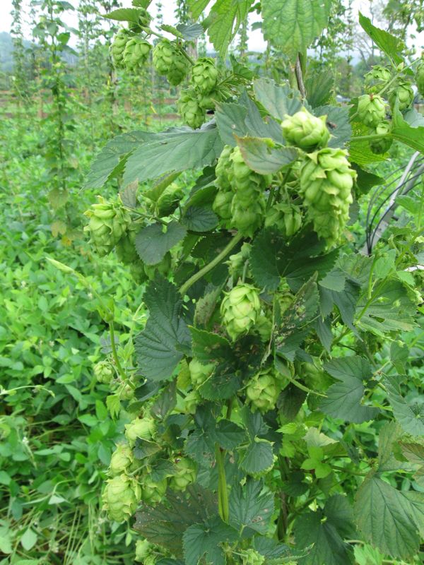
Bring a pair of good yard scissors and help Blue Mountain Brewery string, trim and train their Cascade and Centennial hops! On Tuesday, April 26th · 3:00pm – 6:00pm Give them an hour of good work and they’ll hook you up with a “hop-hand” sandwich–carnivore or vegetarian style–and a side. They’ll be wrapping up the stringin’ by 6PM, so last check in time is precisely 5PM for this event. Co-owner and brewmaster Taylor Smack laughingly has a suggestion. “Basically, what we’re saying is fake a stomach ache at work sometime between 2:30 and 4:30 and get on out here for some good, beery, country fun!” Brewers Chad, Mitch, Matt and Taylor and Stan “the hop man” Driver will be out in the field working and chatting it up with all comers. Hope to see you!

(Seriously, don’t forget your scissors or a good box-knife or the like.)

Blue Ridge Oyster Festival 2011

0
©2011 www.nelsoncountylife.com : Folks lounged into Saturday afternoon at the 1st Annual Blue Ridge Oyster Festival in Roseland, Virginia. (4.23.11)

Roseland
Nelson County, Virginia

It was a perfect afternoon for the 1st Annual Blue Ridge Oyster Festival held in Roseland at Devils Backbone Brewing. The new event featured steamed and raw Mobjack Bay Oysters along with a lots of local food and entertainment.

Families and friends danced into the sunset at the 2011 Blue Ridge Oyster Festival this past Saturday (4.23.11)

To learn more about the BROF, head on over to their website: http://blueridgeoysterfest.com/

NCL Web Reader Captures Photo Of Possible Funnel Cloud Aloft

0
Photo By Sean Phillips : Sean captured what is most likely a funnel cloud aloft along Davis Creek Road north of Lovingston. This was taken with a camera phone in mid-April.

David Creek Road
North Of Lovingston
Nelson County, Virginia

Sean Phillips (most of you know him from Stoney Creek Pharmacy in Nellysford) recently sent us this picture he shot from his camera phone earlier in mid April. Sean said he snapped this shot right after the funnel started going back up in the sky along Davis Creek Road, In all likelihood, it was a real funnel, what you see in this picture is a dissipating phase. This was during a period of very active severe weather across the area.

Good get Sean!

NCPRD Annual Egg Hunt

0

Event Details:

Boys & Girls ages 10 & under.
Join us at 9:30 for crafts & activities. The HUNT begins promptly at 10 am. Bring a basket or bag per child.

Event Date

Saturday, April 23, 2011

Event Time

From: 09:30 – To: 10:30

Event Venue

Nelson Center

Event Contact Details:

434-263-7130

Website:

http://www.nelsoncounty.com

Event TimeZone

US/Eastern

Event by:

Nelson Recreation

- Advertisement -