Present: Mr. Joe Dan Johnson, Mr. Tommy Bruguiere, Mr. Allen Hale, Ms. Connie Brennan and Mr. Tommy Harvey
VDOT SECONDARY SIX-YEAR PLAN: Mr. Randy Hamilton presented the draft six-year plan which included maintenance; signage; traffic studies; a left-turn lane at Rt. 634 East off Rt. 6 (River Road); a turn lane for Rt. 639 off Rt. 6 (Irish Road); .10 route 681 Pigeon Hill Road; .50 miles Rt. 662 S. Powell’s Island. Supervisors tabled further discussion.
FY11-12 BUDGET: Ms. McCann presented a budget of –
General Fund $32,862,782
School Fund $24,403,800
Textbook Fund $578,859
Debt Service Fund $3,798,141
Capital Fund $600,000
Courthouse Project $2,267,115
Broadband Project $2,206,420
CDBG Grant Fund $898,000
Piney River Water/Sewer $220,314
With no public comment, Supervisors tabled further action.
Supervisors met in closed session on a personnel matter.
A SEVERE THUNDERSTORM WATCH is in effect for Nelson, Wintergreen and most of Central Virginia until 8PM EDT Friday night. Look to the right under NELSON WEATHER BULLETINS for the latest text updates. SEVERE THUNDERSTORM WATCH
Scroll for specific county and city area information.
Severe Thunderstorm Watch
Statement as of 7:36 PM EDT on May 27, 2011
The National Weather Service has cancelled Severe Thunderstorm
Watch 388 for the following areas
In Virginia this cancels 19 counties
In central Virginia
Albemarle Greene King George
Nelson Orange Spotsylvania
In northern Virginia
Culpeper Fauquier Stafford
In northwest Virginia
Clarke Frederick Madison
Page Rappahannock Shenandoah
Warren
In western Virginia
Augusta Highland Rockingham
In West Virginia this cancels 5 counties
In northeast West Virginia
Grant Hampshire Hardy
Mineral Pendleton
In Virginia this cancels 6 independent cities
In central Virginia
Charlottesville City of Fredericksburg
In northwest Virginia
City of Harrisonburg City of Winchester
In western Virginia
City of Staunton City of Waynesboro
This includes the cities of…Bayard…Berryville…
Charlottesville…Culpeper…Dahlgren…Elk Garden…Falmouth…
Fort Ashby…Franklin…Front Royal…Greenfield…Harrisonburg…
Keyser…Luray…Madison…Monterey…Moorefield…Mount Storm…
Orange…Petersburg…Romney…Spotsylvania courthouse…
Stanardsville…Staunton…Strasburg…Warrenton…Washington…
Waynesboro…Winchester and Woodstock.
URGENT – IMMEDIATE BROADCAST REQUESTED
SEVERE THUNDERSTORM WATCH NUMBER 388
NWS STORM PREDICTION CENTER NORMAN OK
1255 PM EDT FRI MAY 27 2011
THE NWS STORM PREDICTION CENTER HAS ISSUED A
SEVERE THUNDERSTORM WATCH FOR PORTIONS OF
DISTRICT OF COLUMBIA
CENTRAL MARYLAND
CENTRAL NEW YORK
CENTRAL AND EASTERN PENNSYLVANIA
NORTHERN VIRGINIA
EASTERN WEST VIRGINIA PANHANDLE
COASTAL WATERS
EFFECTIVE THIS FRIDAY AFTERNOON AND EVENING FROM 1255 PM UNTIL
800 PM EDT.
HAIL TO 2 INCHES IN DIAMETER…THUNDERSTORM WIND GUSTS TO 70
MPH…AND DANGEROUS LIGHTNING ARE POSSIBLE IN THESE AREAS.
THE SEVERE THUNDERSTORM WATCH AREA IS APPROXIMATELY ALONG AND 75
STATUTE MILES EAST AND WEST OF A LINE FROM 20 MILES SOUTH OF
CHARLOTTESVILLE VIRGINIA TO 50 MILES NORTHEAST OF ITHACA NEW
YORK. FOR A COMPLETE DEPICTION OF THE WATCH SEE THE ASSOCIATED
WATCH OUTLINE UPDATE (WOUS64 KWNS WOU8).
REMEMBER…A SEVERE THUNDERSTORM WATCH MEANS CONDITIONS ARE
FAVORABLE FOR SEVERE THUNDERSTORMS IN AND CLOSE TO THE WATCH
AREA. PERSONS IN THESE AREAS SHOULD BE ON THE LOOKOUT FOR
THREATENING WEATHER CONDITIONS AND LISTEN FOR LATER STATEMENTS
AND POSSIBLE WARNINGS. SEVERE THUNDERSTORMS CAN AND OCCASIONALLY
DO PRODUCE TORNADOES.
OTHER WATCH INFORMATION…CONTINUE…WW 387…
DISCUSSION…SCATTERED THUNDERSTORMS WILL FORM THIS AFTERNOON IN
CORRIDOR OF MODERATE INSTABILITY FROM NORTHERN VA INTO PORTIONS OF
PA/NY. RATHER STRONG MID LEVEL WINDS AND STEEP LOW/MID LEVEL LAPSE
RATES WILL PROMOTE ORGANIZED STORMS INCLUDING A FEW SUPERCELLS.
LOCALLY DAMAGING WINDS AND HAIL ARE THE MAIN THREATS.
AVIATION…A FEW SEVERE THUNDERSTORMS WITH HAIL SURFACE AND ALOFT
TO 2 INCHES. EXTREME TURBULENCE AND SURFACE WIND GUSTS TO 60
KNOTS. A FEW CUMULONIMBI WITH MAXIMUM TOPS TO 500. MEAN STORM
MOTION VECTOR 23035.
City & county outline areas below:
SEVERE THUNDERSTORM WATCH OUTLINE UPDATE FOR WS 388
NWS STORM PREDICTION CENTER NORMAN OK
1255 PM EDT FRI MAY 27 2011
SEVERE THUNDERSTORM WATCH 388 IS IN EFFECT UNTIL 800 PM EDT
FOR THE FOLLOWING LOCATIONS
VA
. VIRGINIA COUNTIES INCLUDED ARE
ALBEMARLE ARLINGTON AUGUSTA
CLARKE CULPEPER FAIRFAX
FAUQUIER FREDERICK GREENE
HIGHLAND KING GEORGE LOUDOUN
MADISON NELSON ORANGE
PAGE PRINCE WILLIAM RAPPAHANNOCK
ROCKINGHAM SHENANDOAH SPOTSYLVANIA
STAFFORD WARREN
VIRGINIA INDEPENDENT CITIES INCLUDED ARE
ALEXANDRIA CHARLOTTESVILLE FAIRFAX
FALLS CHURCH FREDERICKSBURG HARRISONBURG
MANASSAS MANASSAS PARK STAUNTON
WAYNESBORO WINCHESTER
Afton
Nelson County, Virginia Update 5.28.11 – 10:30 AM EDT
NCL has been able to verify that the calls being placed are by someone identify themselves as the The Nelson Guide and they are trying to get people to by magnets of some sort. Via a mutual client of The Nelson Guidebook and NCL , we were told about the information Saturday morning. NCL and the legitimate Nelson County Guidebook are not related, but they are nice folks and very legitimate. The people posing as them are not.
So obviously is someone calls with posing as The Nelson Guide and is trying to sell you magnets, and obtain any personal financial info, don’t fall for it!
Original Post from 5.27.11 @ 11:41 AM EDT
It’s come to our attention here at NCL that phone scammers are at it again in Nelson County. This time they may be calling in the name of Nelson County Life Magazine, or other Nelson County organizations or businesses. The say they are soliciting ad money. If you receive such a call it IS NOT us. We know for sure such calls have been made in the past 24 hours using names such as Nelson County Guidebook, which is a legitimate publication like ours, though there is no business connection between the two.
The caller may be using a variety of legitimate business names with Nelson County in the title. This is very similar to scams in the past that have used police or sheriff organizations to trick people into donating or revealing sensitive bank information. Don’t fall for it. If it sounds suspicious, it is. One person we talked to this morning reports the call, obviously, came from a telephone number that was blocked or unavailable on caller ID.
Local banks reports having such inquires as well. Nelson County Life NEVER makes unsolicited telephone calls requesting ad money. If you are an established customer, you know how we operate, and new clients would never receive such a call.
We highly encourage you to report any such phone calls to the Nelson County Sheriff’s Department at(434) 263-7050 and your local bank, if you did reveal any account information.
Get in some golf and tennis, time at the spa, beach play down at Lake Monocan and don’t forget to head to Discovery Ridge for exciting family adventures!
Via NWS & SPC : A Severe Thunderstorm Watch is in effect until 8PM EDT for all of the areas shaded in blue. Virtually all of Central Virginia is under this watch or adjoining other watches. Look to the right under Nelson Weather Bulletins for the latest updates.
Severe Thunderstorm Watch
Statement as of 4:42 PM EDT on May 24, 2011
The National Weather Service has cancelled Severe Thunderstorm
Watch 355 for the following areas
In Virginia this cancels 14 counties
In central Virginia
Albemarle Greene King George
Nelson Orange Spotsylvania
In northern Virginia
Culpeper Stafford
In northwest Virginia
Madison Page Rappahannock
In western Virginia
Augusta Highland Rockingham
In Virginia this cancels 5 independent cities
In central Virginia
Charlottesville City of Fredericksburg
In northwest Virginia
City of Harrisonburg
In western Virginia
City of Staunton City of Waynesboro
This includes the cities of…Charlottesville…Culpeper…
Dahlgren…Falmouth…Greenfield…Harrisonburg…Luray…
Madison…Monterey…Orange…Spotsylvania courthouse…
Stanardsville…Staunton…Washington and Waynesboro.
SEVERE THUNDERSTORM WATCH NUMBER 355 Rebroadcast – Original watch issued at 12:40 PM EDT Scroll for county / city outline updates.
URGENT – IMMEDIATE BROADCAST REQUESTED
SEVERE THUNDERSTORM WATCH NUMBER 355
NWS STORM PREDICTION CENTER NORMAN OK
1240 PM EDT TUE MAY 24 2011
THE NWS STORM PREDICTION CENTER HAS ISSUED A
SEVERE THUNDERSTORM WATCH FOR PORTIONS OF
SOUTHEAST MARYLAND
NORTHERN NORTH CAROLINA
CENTRAL AND EASTERN VIRGINIA
COASTAL WATERS
EFFECTIVE THIS TUESDAY AFTERNOON AND EVENING FROM 1240 PM UNTIL
800 PM EDT.
HAIL TO 1.5 INCHES IN DIAMETER…THUNDERSTORM WIND GUSTS TO 70
MPH…AND DANGEROUS LIGHTNING ARE POSSIBLE IN THESE AREAS.
THE SEVERE THUNDERSTORM WATCH AREA IS APPROXIMATELY ALONG AND 100
STATUTE MILES EAST AND WEST OF A LINE FROM 55 MILES WEST
NORTHWEST OF PATUXENT RIVER MARYLAND TO 30 MILES SOUTHEAST OF
ROCKY MOUNT NORTH CAROLINA. FOR A COMPLETE DEPICTION OF THE
WATCH SEE THE ASSOCIATED WATCH OUTLINE UPDATE (WOUS64 KWNS WOU5).
REMEMBER…A SEVERE THUNDERSTORM WATCH MEANS CONDITIONS ARE
FAVORABLE FOR SEVERE THUNDERSTORMS IN AND CLOSE TO THE WATCH
AREA. PERSONS IN THESE AREAS SHOULD BE ON THE LOOKOUT FOR
THREATENING WEATHER CONDITIONS AND LISTEN FOR LATER STATEMENTS
AND POSSIBLE WARNINGS. SEVERE THUNDERSTORMS CAN AND OCCASIONALLY
DO PRODUCE TORNADOES.
OTHER WATCH INFORMATION…CONTINUE…WW 352…WW 353…WW 354…
DISCUSSION…NOCTURNAL MCS CURRENTLY EMERGING FROM THE BLUE RIDGE
HAS SHOWN A RAPID INCREASE IN STORM COVERAGE AND INTENSITY ALONG
ERN/SRN PERIPHERY OF SYSTEM COLD POOL. AMBIENT INFLOW AIR MASS HAS
WARMED INTO THE 80S. WHEN COUPLED WITH BOUNDARY LAYER DEWPOINTS IN
THE 60S…ENVIRONMENT HAS BECOME MODERATELY UNSTABLE WITH MLCAPE
VALUES OF 1000-2000 J/KG. GIVEN 40-50 KT WLY FLOW OBSERVED IN THE
700-500 MB LAYER /PER REGIONAL VAD DATA/…SETUP WILL FAVOR
ORGANIZED STORM MODES INCLUDING LINE SEGMENTS AND SUPERCELLS CAPABLE
OF DAMAGING WINDS AND HAIL.
AVIATION…A FEW SEVERE THUNDERSTORMS WITH HAIL SURFACE AND ALOFT
TO 1.5 INCHES. EXTREME TURBULENCE AND SURFACE WIND GUSTS TO 60
KNOTS. A FEW CUMULONIMBI WITH MAXIMUM TOPS TO 500. MEAN STORM
MOTION VECTOR 28035.
Cities and counties included in watch.
Severe Thunderstorm Watch
Statement as of 12:40 PM EDT on May 24, 2011
Severe Thunderstorm Watch 355 is in effect until 800 PM EDT
VA
. Virginia counties included are
Accomack Albemarle Amelia
Augusta Brunswick Caroline
Charles City Chesterfield Culpeper
Cumberland Dinwiddie Essex
Fluvanna Gloucester Goochland
Greene Greensville Hanover
Henrico Highland Isle of Wight
James City King And Queen King George
King William Lancaster Louisa
Lunenburg Madison Mathews
Mecklenburg Middlesex Nelson
New Kent Northampton Northumberland
Nottoway Orange Page
Powhatan Prince Edward Prince George
Rappahannock Richmond Rockingham
Southampton Spotsylvania Stafford
Surry Sussex Westmoreland
York
Gone are the stainless steel accent panels and particle board wall treatments. Immediately you notice the design and architectural touches which evoke a warm, rustic, mountain-top lodge environment.Natural wood. Reclaimed and refinished planks from old barns. New tables, chairs, and booths. Wooden beams and trusses across the ceiling, and new chandeliers to light the way to your table.A totally new look and feel of the seating that overlooks the slopes at Wintergreen.
The menu has been totally revamped to focus on regional Southern dishes. They’ve kept the popular items, of course. But in addition to our renown burgers and wings, you’ll also find Stuffed Sweet Potato Skins, a fresh Catfish Po’ Boy, a Green Tomato BLT Panini, and Mountain Jambalaya. If this all sounds intriguing, click here (pdf) to take a look at the complete menu.
The face lift also includes newly renovated bathrooms featuring tiled walls and a granite top on the vanity.
Wintergreen says: “You’ll recognize the faces of our staff—they haven’t changed. But that’s about the only thing that hasn’t at the new Edge. Please join us soon to celebrate a whole new way to enjoy the views on the mountain!”
Cannery Loop & US 29
Near Lovingston
Nelson County, Virginia
VDOT workers made a gruesome discovery Monday afternoon just north of Lovingston. “This was the body of a 42 year old white male that was found by a VDOT worker cutting the right of way near Cannery Loop and US Route 29. The call came into our department around 2:15 PM,” said Nelson County Sheriff, David Brooks.
View Larger Map The general area above where lawmen were investigating the scene along Cannery Loop.
Sheriff Brooks said he does not suspect foul play in the investigation and did say the person had been reported missing several days earlier. The name has not been released pending notification of kin. The body has been sent to the medical examiner’s office for an autopsy.
Via NWS : A Severe Thunderstorm Watch is in effect for all of the areas shaded in pink until 6PM EDT Monday evening. Look to your right under Nelson Weather Alerts for the latest bulletin updates.
SEVERE THUNDERSTORM WATCH #338
Scroll down for counties and cities included in the watch area
URGENT – IMMEDIATE BROADCAST REQUESTED
SEVERE THUNDERSTORM WATCH NUMBER 338
NWS STORM PREDICTION CENTER NORMAN OK
1050 AM EDT MON MAY 23 2011
THE NWS STORM PREDICTION CENTER HAS ISSUED A
SEVERE THUNDERSTORM WATCH FOR PORTIONS OF
DISTRICT OF COLUMBIA
MARYLAND
CENTRAL PENNSYLVANIA
NORTHERN VIRGINIA
EASTERN WEST VIRGINIA PANHANDLE
COASTAL WATERS
EFFECTIVE THIS MONDAY MORNING AND EVENING FROM 1050 AM UNTIL 600
PM EDT.
HAIL TO 1.5 INCHES IN DIAMETER…THUNDERSTORM WIND GUSTS TO 70
MPH…AND DANGEROUS LIGHTNING ARE POSSIBLE IN THESE AREAS.
THE SEVERE THUNDERSTORM WATCH AREA IS APPROXIMATELY ALONG AND 70
STATUTE MILES EAST AND WEST OF A LINE FROM 50 MILES EAST
NORTHEAST OF STATE COLLEGE PENNSYLVANIA TO 25 MILES EAST OF
CHARLOTTESVILLE VIRGINIA. FOR A COMPLETE DEPICTION OF THE WATCH
SEE THE ASSOCIATED WATCH OUTLINE UPDATE (WOUS64 KWNS WOU8).
REMEMBER…A SEVERE THUNDERSTORM WATCH MEANS CONDITIONS ARE
FAVORABLE FOR SEVERE THUNDERSTORMS IN AND CLOSE TO THE WATCH
AREA. PERSONS IN THESE AREAS SHOULD BE ON THE LOOKOUT FOR
THREATENING WEATHER CONDITIONS AND LISTEN FOR LATER STATEMENTS
AND POSSIBLE WARNINGS. SEVERE THUNDERSTORMS CAN AND OCCASIONALLY
DO PRODUCE TORNADOES.
OTHER WATCH INFORMATION…CONTINUE…WW 337…
DISCUSSION…TSTMS CURRENTLY DEVELOPING AHEAD OF MCV FROM WRN PA TO
ERN VA SHOULD CONTINUE TO INCREASE IN COVERAGE AND INTENSITY THIS
AFTERNOON AS ACTIVITY ENCOUNTERS A DESTABILIZING AIR MASS E OF THE
BLUE RIDGE. THE COMBINATION OF MLCAPE INCREASING TO 1000-2000 J/KG
AND STRONG WLY MID-TROPOSPHERIC FLOW /REF. 12Z ILN SOUNDING/ WILL
PROMOTE UPSCALE GROWTH OF STORMS INTO AN MCS CAPABLE OF LARGE HAIL
AND DAMAGING WIND GUSTS.
AVIATION…A FEW SEVERE THUNDERSTORMS WITH HAIL SURFACE AND ALOFT
TO 1.5 INCHES. EXTREME TURBULENCE AND SURFACE WIND GUSTS TO 60
KNOTS. A FEW CUMULONIMBI WITH MAXIMUM TOPS TO 500. MEAN STORM
MOTION VECTOR 27035.
…MEAD
COUNTY / CITY OUTLINE AREAS
SEVERE THUNDERSTORM WATCH OUTLINE UPDATE FOR WS 338
NWS STORM PREDICTION CENTER NORMAN OK
1050 AM EDT MON MAY 23 2011
SEVERE THUNDERSTORM WATCH 338 IS IN EFFECT UNTIL 600 PM EDT
FOR THE FOLLOWING LOCATIONS
VA
. VIRGINIA COUNTIES INCLUDED ARE
ALBEMARLE ARLINGTON AUGUSTA
CLARKE CULPEPER FAIRFAX
FAUQUIER FREDERICK GREENE
HIGHLAND KING GEORGE LOUDOUN
MADISON NELSON ORANGE
PAGE PRINCE WILLIAM RAPPAHANNOCK
ROCKINGHAM SHENANDOAH SPOTSYLVANIA
STAFFORD WARREN
VIRGINIA INDEPENDENT CITIES INCLUDED ARE
ALEXANDRIA CHARLOTTESVILLE FAIRFAX
FALLS CHURCH FREDERICKSBURG HARRISONBURG
MANASSAS MANASSAS PARK STAUNTON
WAYNESBORO WINCHESTER
$$
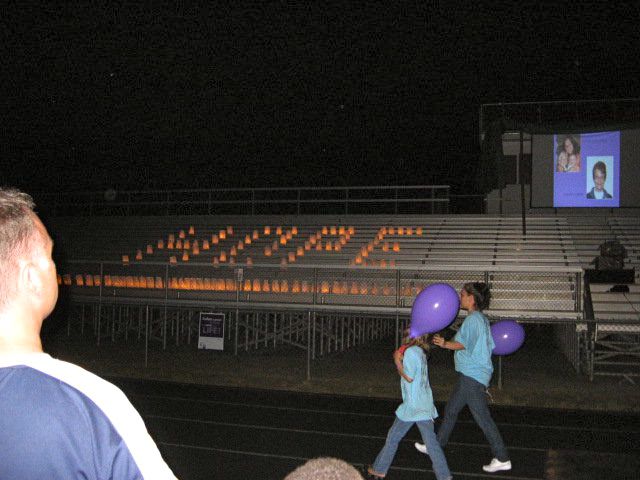
Photos Courtesy of Sherri Brooks : Luminaries light up the stands at Nelson County High School for the annual Relay For Life held this past Saturday 5.21.11
Lovingston
Nelson County, Virginia
It was a time of hope, reflection and fun for teams participating in the annual Relay For Life here in Nelson County. The event is held outdoors at Nelson County High School.
Amber Drumheller Mooney (right) who helped organize the 2011 event, takes a break for a lighter moment posing with one of the more colorful participants in the RFL held this past Saturday in Lovingston. Luminaries remember and honor those stricken with cancer.
According to the American Cancer Society’s Nelson page, there were 34 teams with 565 participants in the 2011 event raising just over $98,000.00 dollars.
Way to go and congrats on a very successful 2011 event!
In this two-day course, learn how to save a life when someone is injured in a wilderness area, or urban disaster zone. This course blends classroom and hands-on rescue scenario practice. 2-year SOLO WFA certification, also counts as recertification for WFR and wilderness part of W-EMT. More info, testimonials, and to register: www.outdoorsocial.com/wfa.htm or 434-760-4453. 10% of proceeds go to Ivy Creek Foundation. Course times: 8:30am – 5:30pm each day.
Event Date
Saturday, May 21, 2011
Event Time
From: 08:30 – To: 17:30
Event Venue
Ivy Creek Natural Area, 1780 Earlysville Road, Charlottesville, VA 22901