Home Blog Page 276

Wintergreen & Nelson : High Wind Watch Friday : Mountain Gusts to 60 MPH Possible

0
Via NWS: A High Wind Watch is is in effect for the areas shaded in brown from Friday morning into the afternoon. Wind gusts of up to 60 MPH are possible, especially in the mountainous areas of Nelson.

HIGH WIND WATCH
URGENT – WEATHER MESSAGE
NATIONAL WEATHER SERVICE BALTIMORE MD/WASHINGTON DC
140 PM EST THU FEB 23 2012

WASHINGTON-FREDERICK MD-CARROLL-EXTREME WESTERN ALLEGANY-
CENTRAL AND EASTERN ALLEGANY-AUGUSTA-ROCKINGHAM-SHENANDOAH-
FREDERICK VA-PAGE-WARREN-CLARKE-NELSON-ALBEMARLE-GREENE-MADISON-
RAPPAHANNOCK-LOUDOUN-NORTHERN FAUQUIER-WESTERN HIGHLAND-
EASTERN HIGHLAND-HAMPSHIRE-MORGAN-BERKELEY-JEFFERSON-HARDY-
WESTERN GRANT-EASTERN GRANT-WESTERN MINERAL-EASTERN MINERAL-
WESTERN PENDLETON-EASTERN PENDLETON-
INCLUDING THE CITIES OF…HAGERSTOWN…FREDERICK…WESTMINSTER…
FROSTBURG…CUMBERLAND…STAUNTON…WAYNESBORO…HARRISONBURG…
WINCHESTER…FRONT ROYAL…CHARLOTTESVILLE…WASHINGTON…
LEESBURG…WARRENTON…HIGHTOWN…MONTEREY…MARTINSBURG…
CHARLES TOWN…MOOREFIELD…BAYARD…MOUNT STORM…PETERSBURG…
ELK GARDEN…KEYSER…FORT ASHBY…CIRCLEVILLE…FRANKLIN
140 PM EST THU FEB 23 2012

…HIGH WIND WATCH IN EFFECT FROM FRIDAY MORNING THROUGH FRIDAY
AFTERNOON…

THE NATIONAL WEATHER SERVICE IN BALTIMORE MD/WASHINGTON HAS
ISSUED A HIGH WIND WATCH…IN EFFECT FROM FRIDAY MORNING THROUGH
FRIDAY AFTERNOON.

* TIMING…STRONGEST WINDS WILL BE FRIDAY AFTERNOON.

* WINDS…WEST 20 TO 30 MPH WITH GUSTS UP TO 60 MPH BY LATE
AFTERNOON.

PRECAUTIONARY/PREPAREDNESS ACTIONS…

A HIGH WIND WATCH MEANS THERE IS THE POTENTIAL FOR A HAZARDOUS
HIGH WIND EVENT. WIND GUSTS OF 58 MPH OR STRONGER MAY OCCUR.
CONTINUE TO MONITOR THE LATEST FORECASTS.

Spring Time Temps On Thursday!

0
©2012 Graphic via wunderground.com : Temperatures in the Mid-Atlantic area, including Nelson, will easily reach into the low and mid 70's Thursday.

Nelson County, Virginia
Last weekend we were talking 30’s and heavy snow. As we end this week, we are talking temps that are a preview of springtime! A very warm air mass will begin affecting the Nelson and Central Virginia area on Thursday and will continue into Friday before a strong cold front brings us back to reality by Saturday. The likelihood of thunderstorms is even in the forecast Friday afternoon and evening as the front passes through.

Between now and then look for scattered showers and possibly a thunderstorm across the area by late in the day Wednesday into Wednesday night with mild mid 60’s before the clouds move in.

With the approaching cold front picking up speed, temps on Friday, while mild, won’t be as warm as Thursday with highs in the lower and mid 60’s

UPDATE: Fire Damages Laurelwood Condo Units At Wintergreen Resort

1
©2012 www.nelsoncountylife.com : All Photos By NCL Mountain Photographer Paul Purpura : Charred wood shows the damage at the Laurelwood Condos at Wintergreen Resort. An early Monday morning fire damaged several units in the complex, one of the first two ever built at the resort decades ago.

Wintergreen Resort
Nelson County, Virginia

NCL first broke the news to you Monday morning in this post, a fire heavily damaged some of the condo units at Laurelwood. That’s at Wintergreen Resort. Numerous area fire departments backed up Wintergreen Fire for the early morning blaze that is believed to have started around the fireplace in one of the units, according to information given to NCL Mountain Photographer Paul Purpura at the scene.

The fire came on one of the busiest weekends of the year for the resort. President's Day Weekend is generally the last big weekend for the winter ski season. Every available unit on the mountain was nearly booked.

The blaze was brought under control just before 8AM Monday morning. Though only a unit or two had actual fire damage, smoke and water damage affected others. No one is believed to have been injured in the fire.

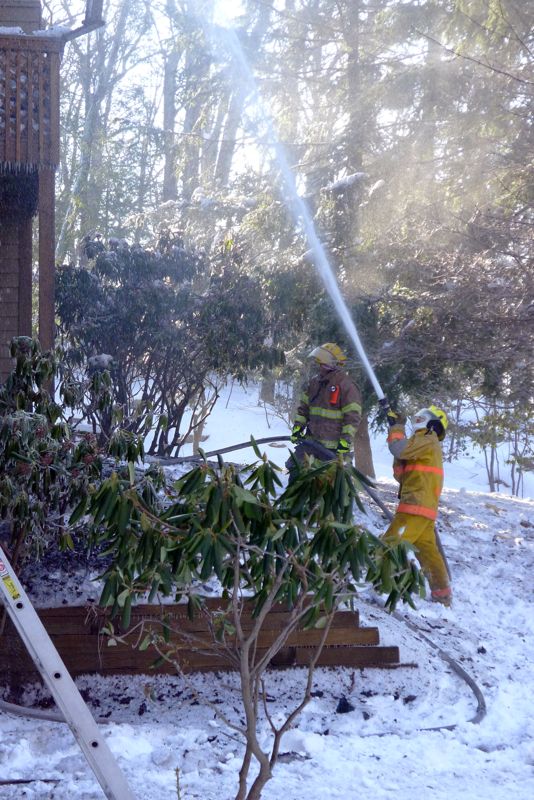
Wintergreen firemen spray water on the last remaining embers during a Monday morning fire at the Laurelwood Condos.
To make matters more difficult, a large snow fell the night before making the firefighting a little bit more of a slippery job!
All roads leading into the resort and condo units were reopened by mid-morning Monday.

More updates as we have them.

BREAKING: Firemen Battle Blaze At Laurelwood Condo Unit : Wintergreen Resort

0
©2012 www.nelsoncountylife.com : Photo By NCL Mountain Photographer Paul Purpura : Tired firefighters with Wintergreen Fire Department get a blaze under control just before 8AM Monday at The Laurelwood Condo units at Wintergreen Resort.

Wintergreen Resort
Nelson County, Virginia

Wintergreen Fire Department has been working a blaze this snowy Monday morning at one of the condo units at Wintergreen Resort. WFD Fire Chief Curtis Sheets confirms is The Laurelwoods condo unit near The Market. NCL Mountain Photographer Paul Purpura is on the scene and is sending us updates as well as photos like the one above.

Map via google.com : Just before 8AM Monday firefighters with WIntergreen FD say they have a blaze contained at The Laurelwoods Condos near The Market. This is the general area of the fire at on the mountain.

We do understand the blaze is under control at this time and WFD is now there in a cleanup capacity only.

Snow Day – Nelson Public Schools CLOSED on Monday 2.20.12

1
©2012 www.nelsoncountylife.com: For a snowstorm that almost didn't happen it was a hit with NCL Jr. Publisher Adam Stafford and mom Yvette as Adam made his first snowman ever!

Nelson County, Virginia
For awhile on Sunday it looked like a forecast holding promises of snow was nothing but a promise. However, around mid-afternoon the skies opened up and the snow started falling heavy across Nelson. First in the southern portions, then on to the north. Enough snow to officially close Nelson County Public Schools on Monday 2.20.12

Photo By Kim Smith: On the mountain at Wintergreen traffic was snarled after cars started piling up at Wintergreen Drive and Blue Ridge Drive.
Photo By Brandon Cox: Down below it wasn't any better. Traffic began piling up on Route 29 just north of Lovingston around mid-afternoon Sunday.

It’s a storm that looked like it wasn’t going to pan out. But it did! By early evening Sunday the National Weather Service out of Sterling, VA finally issued a Winter Storm Warning. One had already been in effect for neighboring Amherst for almost 24 hours.

Photo By Jenn Rhubright : But mostly the snow created beautiful scenes like these on the Tye River.
Tons of you shared your snow pics to our Facebook Timeline. Head on over there to see many more of them! That's facebook.com/NelsonCounty

More updates as we have them!

Wintergreen & Nelson : Winter Storm Warning : CANCELED

0
Via NWS: A Winter Storm Warning is in effect for Nelson & Wintergreen along with other areas shaded in pink, until 1AM Monday morning.

WINTER STORM WARNING
URGENT – WINTER WEATHER MESSAGE
NATIONAL WEATHER SERVICE BALTIMORE MD/WASHINGTON DC
522 PM EST SUN FEB 19 2012

AUGUSTA-NELSON-
INCLUDING THE CITIES OF…STAUNTON…WAYNESBORO
522 PM EST SUN FEB 19 2012

…WINTER STORM WARNING IN EFFECT UNTIL 1 AM EST MONDAY…

THE NATIONAL WEATHER SERVICE IN BALTIMORE MD/WASHINGTON HAS
ISSUED A WINTER STORM WARNING FOR SNOW…WHICH IS IN EFFECT UNTIL 1
AM EST MONDAY. THE WINTER WEATHER ADVISORY IS NO LONGER IN EFFECT.

* PRECIPITATION TYPE…SNOW.

* ACCUMULATIONS…5 TO 8 INCHES.

* TIMING…SNOW WILL CONTINUE THROUGH THE EVENING. SNOW MAY BE
MODERATE AT TIMES. SNOW IS EXPECTED TO END LATE THIS EVENING.

* TEMPERATURES…IN THE UPPER 20S.

* WINDS…NORTH 10 TO 15 MPH WITH GUSTS UP TO 20 MPH.

* IMPACTS…VISIBILITY RESTRICTIONS IN SNOW. ROADS MAY BECOME
SNOW COVERED…CREATING HAZARDOUS TRAVEL.

PRECAUTIONARY/PREPAREDNESS ACTIONS…

A WINTER STORM WARNING MEANS SIGNIFICANT AMOUNTS OF SNOW…
SLEET…AND ICE ARE EXPECTED OR OCCURRING. THIS WILL MAKE TRAVEL
VERY HAZARDOUS OR IMPOSSIBLE.

Wintergreen & Nelson : Winter Weather Advisory From 10AM Sunday Until 1AM Monday

0
Via NWS: A WINTER WEATHER ADVISORY begins for the areas shaded in purple at 10AM Sunday morning until 1AM Monday morning, this replaces the earlier issued Winter Storm Watch.

WINTER WEATHER ADVISORY
URGENT – WINTER WEATHER MESSAGE
NATIONAL WEATHER SERVICE BALTIMORE MD/WASHINGTON DC
312 AM EST SUN FEB 19 2012

AUGUSTA-NELSON-WESTERN HIGHLAND-EASTERN HIGHLAND-
INCLUDING THE CITIES OF…STAUNTON…WAYNESBORO…HIGHTOWN…
MONTEREY
312 AM EST SUN FEB 19 2012

…WINTER WEATHER ADVISORY REMAINS IN EFFECT FROM 10 AM THIS
MORNING TO 1 AM EST MONDAY…

* PRECIPITATION TYPE…SNOW…POSSIBLY MIXED WITH RAIN AT ONSET.

* ACCUMULATIONS…2 TO 4 INCHES.

* TIMING…PERIODS OF SNOW DEVELOPING THIS MORNING. SNOW MAY BE
MODERATE AT TIMES THIS AFTERNOON AND EARLY EVENING. SNOW IS
EXPECTED TO END LATE THIS EVENING.

* TEMPERATURES…IN THE LOWER 30S.

* WINDS…NORTHEAST 10 TO 15 MPH WITH GUSTS UP TO 20 MPH.

* IMPACTS…VISIBILITY RESTRICTIONS IN SNOW. ROADS MAY BECOME
SNOW COVERED…CREATING HAZARDOUS TRAVEL
.

PRECAUTIONARY/PREPAREDNESS ACTIONS…

A WINTER WEATHER ADVISORY FOR SNOW MEANS THAT PERIODS OF SNOW
WILL CAUSE PRIMARILY TRAVEL DIFFICULTIES. BE PREPARED FOR SNOW
COVERED ROADS AND LIMITED VISIBILITIES…AND USE CAUTION WHILE
DRIVING.

Updated: Snow Estimate Map For Sunday : Updated 10:00AM – 2.19.12

0
Via CBS-019 in Charlottesville: Possible snowfall throughout Sunday.

Nelson County, Virginia

Updated 10:00AM 2.19.12
Overnight Saturday into Sunday, it appears weather models and radar information indicate the expected intensity of snowfall will not be as great across our area. However, the threat does continue for some light snowfall. All in all this appears to be a bust folks. Simply put.

As we have been talking about for the past several days, some winter weather appears to be headed for Central Virginia, including Nelson County. It is a significant since it is hitting this late in the winter season with only a month of official winter left. Less for meteorologists. They pretty much consider it to be done at the end of February in this part of the country.

We may see 1-3″, incicated in the map above. Actually piling up? Doubtful. Technically, probably. It doesn’t take a rocket scientist to know we have been very warm the past two days, reaching a high of 62° here in Nelson on Saturday afternoon. So as the snow begins on Sunday, it will take a while, even with temps dropping throughout the day, to begin accumulating, particularly on roadways. But, we will have abundant moisture in place and the cold air will soon follow. Plus, this will be a very wet snow, so it will compact easily. By 10AM reports of the ground being lightly covered in Montebello and other areas along the BRP were coming in. Most of them southern Nelson.

As of 7AM eastern on Sunday, the NWS office covering Nelson (based in Sterling) has issued a WINTER WEATHER ADVISORY for the area. One county over, the NWS office out of Blacksburg covering Amherst continues to have a WINTER STORM WARNING in effect there..

More updates as needed throughout the weekend.

And if you get snow pics, send them to: snowpics@nelsoncountylife.com

Wintergreen & Nelson : Winter Storm Watch Begins Sunday : Updated 7:07PM – 2.18.12

0

WINTER STORM WATCH
URGENT – WINTER WEATHER MESSAGE
NATIONAL WEATHER SERVICE BALTIMORE MD/WASHINGTON DC
707 PM EST SAT FEB 18 2012

AUGUSTA-ROCKINGHAM-SHENANDOAH-PAGE-WARREN-NELSON-ALBEMARLE-GREENE-
MADISON-RAPPAHANNOCK-ORANGE-CULPEPER-WESTERN HIGHLAND-
EASTERN HIGHLAND-HARDY-WESTERN GRANT-EASTERN GRANT-
WESTERN PENDLETON-EASTERN PENDLETON-
INCLUDING THE CITIES OF…STAUNTON…WAYNESBORO…HARRISONBURG…
FRONT ROYAL…CHARLOTTESVILLE…WASHINGTON…CULPEPER…
HIGHTOWN…MONTEREY…MOOREFIELD…BAYARD…MOUNT STORM…
PETERSBURG…CIRCLEVILLE…FRANKLIN
1007 AM EST SAT FEB 18 2012

…WINTER STORM WATCH REMAINS IN EFFECT FROM SUNDAY MORNING
THROUGH LATE SUNDAY NIGHT…

* PRECIPITATION TYPE…SNOW.

* ACCUMULATIONS…5 OR MORE INCHES POSSIBLE. THIS STORM WILL
EXHIBIT A TIGHT GRADIENT OF SNOWFALL FROM SOUTH /GREATER/ TO
NORTH /LESSER/.

* TIMING…SNOW DEVELOPING SUNDAY MORNING. SNOW MAY BE HEAVY AT
TIMES SUNDAY AFTERNOON AND EARLY EVENING. SNOW IS EXPECTED TO
END BY LATE SUNDAY NIGHT.

* TEMPERATURES…LOWER TO MID 30S SUNDAY…FALLING INTO THE LOWER
TO MID 20S SUNDAY NIGHT.

* WINDS…NORTHEAST AROUND 10 MPH.

* IMPACTS…SIGNIFICANT VISIBILITY RESTRICTIONS ARE EXPECTED IN
SNOW. ROADS MAY BECOME SNOW COVERED…CREATING HAZARDOUS
TRAVEL.

PRECAUTIONARY/PREPAREDNESS ACTIONS…

A WINTER STORM WATCH MEANS THERE IS A POTENTIAL FOR SIGNIFICANT
SNOW ACCUMULATIONS THAT MAY IMPACT TRAVEL.

LISTEN TO NOAA WEATHER RADIO OR YOUR LOCAL MEDIA FOR THE LATEST
UPDATES ON THIS SITUATION.

Significant Winter Event Shaping Up For 2nd Half Of President’s Day Weekend : Update 12:30PM

0
Graphic via CBS-19 Charlottesville : As of noon Friday here's a general estimate of possible snow this weekend by NCL's news partners over at CBS-19.

Nelson County
And All of Central Virginia

As of noon Friday, all of the elements appear to be on track for a significant winter weather event over a part of the upcoming President’s Day weekend that extened through Monday. Numerous private weather services such as Accuweather.com and, closer to home, WxRisk.com based here in Virginia have been talking about the potential for this storm over the past several days. Forecasters at the NWS are beginning to make mention of this in their area forecast discussions, but not much else currently. Look for that to change dramatically in the coming hours.

Map image ©2012 accuweather.com : Accuweather seems to agree with significant snowfall across our region.

So how much snow are we talking about? Given current information, 5+ inches of snow Sunday night into Monday morning is not out of the question for Nelson proper. I have been consulting with Chief Meteorologist Travis Koshko over at our News Partner CBS-19 in Charlottesville Friday morning. Travis released his first estimate map today at noon. (See above)

Stay tuned, as this is very fluid at the moment, but again, it does appear to be a significant winter weather event, particularly as we are getting near the end of the real winter season in our area.

This post will be updated throughout the day so be sure to check it often, and we will feed those updates to our Facebook and Twitter feeds as well.

- Advertisement -