Home Blog Page 261

Wintergreen & Nelson : Severe Thunderstorm Watch – CANCELED @ 1:38AM

0

Via NWS: A Severe Thunderstorm Watch has been issued for the areas shaded in pink until 2AM Monday morning.

Severe Thunderstorm Watch
Statement as of 1:38 AM EDT on July 02, 2012

The National Weather Service has cancelled Severe Thunderstorm
Watch 452 for the following areas

In Maryland this cancels 1 County

In north central Maryland

Washington

In Virginia this cancels 8 counties

In central Virginia

Nelson

In northwest Virginia

Clarke Frederick Page
Shenandoah Warren

In western Virginia

Augusta Rockingham

In West Virginia this cancels 5 counties

In northeast West Virginia

Berkeley Hampshire Hardy
Jefferson Morgan

In Virginia this cancels 4 independent cities

In northwest Virginia

City of Harrisonburg City of Winchester

In western Virginia

City of Staunton City of Waynesboro

This includes the cities of…Berryville…Charles Town…
Front Royal…Greenfield…Hagerstown…Harrisonburg…Luray…
Martinsburg…Moorefield…Paw Paw…Romney…Staunton…
Strasburg…Waynesboro…Winchester and Woodstock.

SEVERE THUNDERSTORM WATCH
Scroll Down For City / County Outline

SEVERE THUNDERSTORM WATCH NUMBER 452
NWS STORM PREDICTION CENTER NORMAN OK
905 PM EDT SUN JUL 1 2012

THE NWS STORM PREDICTION CENTER HAS ISSUED A
SEVERE THUNDERSTORM WATCH FOR PORTIONS OF

EASTERN KENTUCKY
WESTERN MARYLAND
WESTERN AND SOUTHWESTERN VIRGINIA
EASTERN WEST VIRGINIA INCLUDING THE EASTERN PANHANDLE

EFFECTIVE THIS SUNDAY NIGHT AND MONDAY MORNING FROM 905 PM UNTIL
200 AM EDT.

HAIL TO 2 INCHES IN DIAMETER…THUNDERSTORM WIND GUSTS TO 70
MPH…AND DANGEROUS LIGHTNING ARE POSSIBLE IN THESE AREAS.

THE SEVERE THUNDERSTORM WATCH AREA IS APPROXIMATELY ALONG AND 80
STATUTE MILES EAST AND WEST OF A LINE FROM 50 MILES WEST
NORTHWEST OF MARTINSBURG WEST VIRGINIA TO 60 MILES SOUTHWEST OF
BLUEFIELD WEST VIRGINIA. FOR A COMPLETE DEPICTION OF THE WATCH
SEE THE ASSOCIATED WATCH OUTLINE UPDATE (WOUS64 KWNS WOU2).

REMEMBER…A SEVERE THUNDERSTORM WATCH MEANS CONDITIONS ARE
FAVORABLE FOR SEVERE THUNDERSTORMS IN AND CLOSE TO THE WATCH
AREA. PERSONS IN THESE AREAS SHOULD BE ON THE LOOKOUT FOR
THREATENING WEATHER CONDITIONS AND LISTEN FOR LATER STATEMENTS
AND POSSIBLE WARNINGS. SEVERE THUNDERSTORMS CAN AND OCCASIONALLY
DO PRODUCE TORNADOES.

OTHER WATCH INFORMATION…CONTINUE…WW 445…WW 446…WW
447…WW 448…WW 449…WW 450…WW 451…

DISCUSSION…SEVERAL CLUSTERS OF THUNDERSTORMS ARE SPREADING ACROSS
EASTERN KY/WESTERN WV AND EASTERN OH…PRODUCING LOCALLY DAMAGING
WINDS AND HAIL. THESE STORMS WILL MOVE ACROSS THE WW AREA THROUGH
THE MID-LATE EVENING. AS USUAL…THERE IS UNCERTAINTY WHETHER
STORMS CAN MAINTAIN INTENSITY AS THEY MOVE ACROSS THE APPALACHIAN
MOUNTAINS INTO WESTERN VA. HOWEVER…MODERATE INSTABILITY AND A
SUBTLE SHORTWAVE TROUGH MOVING THROUGH THE AREA SUGGEST THE
POTENTIAL THAT STORMS WILL PERSIST FOR SEVERAL MORE HOURS.

AVIATION…A FEW SEVERE THUNDERSTORMS WITH HAIL SURFACE AND ALOFT
TO 2 INCHES. EXTREME TURBULENCE AND SURFACE WIND GUSTS TO 60
KNOTS. A FEW CUMULONIMBI WITH MAXIMUM TOPS TO 500. MEAN STORM
MOTION VECTOR 30035.

County / City Outline
SEVERE THUNDERSTORM WATCH OUTLINE UPDATE FOR WS 452
NWS STORM PREDICTION CENTER NORMAN OK
905 PM EDT SUN JUL 1 2012

SEVERE THUNDERSTORM WATCH 452 IS IN EFFECT UNTIL 200 AM EDT
FOR THE FOLLOWING LOCATIONS

VAC005-009-015-017-019-021-023-027-035-043-045-051-063-067-069-
071-077-091-105-121-125-139-141-155-161-163-165-167-169-171-173-
185-187-191-195-197-515-520-530-580-660-678-680-720-770-775-790-
820-840-020600-
/O.NEW.KWNS.SV.A.0452.120702T0105Z-120702T0600Z/

VA
. VIRGINIA COUNTIES INCLUDED ARE

ALLEGHANY AMHERST AUGUSTA
BATH BEDFORD BLAND
BOTETOURT BUCHANAN CARROLL
CLARKE CRAIG DICKENSON
FLOYD FRANKLIN FREDERICK
GILES GRAYSON HIGHLAND
LEE MONTGOMERY NELSON
PAGE PATRICK PULASKI
ROANOKE ROCKBRIDGE ROCKINGHAM
RUSSELL SCOTT SHENANDOAH
SMYTH TAZEWELL WARREN
WASHINGTON WISE WYTHE

VIRGINIA INDEPENDENT CITIES INCLUDED ARE

BEDFORD BRISTOL BUENA VISTA
COVINGTON HARRISONBURG LEXINGTON
LYNCHBURG NORTON ROANOKE
SALEM STAUNTON WAYNESBORO
WINCHESTER
$$

Gas Lines Becoming Familiar Sight After Power Outages

0
Photo Courtesy of Heidi Crandall : This gas line was in Lexington, Virginia Sunday afternoon.

Central Virginia
Since Friday night’s storm hit much of the State of Virginia, people have been scurrying to find a place that had electricity to pump fuel. Lines have been forming all over Nelson and beyond. Heidi Crandall sent us this shot from Lexington, VA. “People as far as Covington coming north looking for gas. A lot of stations closed due to damage or ran out of gas,” she told us by email late Sunday.

Better keep that tank topped off for the next few days!

Latest Update From CVEC On Power Outages As of 3PM July 1st

0

Outage Update – July 1, 3 PM

CVEC has an estimated 6700 outage as of 3 PM with the vast majority of them in Nelson and Albemarle County. Here is a breakdown of the outages by Substation area:

Whitehall has 1344 while Red Hill has 253 in Albemarle. Whitehall is still waiting for Dominion to restore transmission service but there is also significaant damage on the distribution side of the substation.
In Nelson County, the Nellysford circuit out of Martins Store has 1433 without service, while the Woodsmill circuit has 246, down from 734.
The Schuyler substation has lost the transmission feed affecting 642 members. When APCO restores transmission service we expect power to flow to a good number of members.
Piney River substation has 1099 members without power on two circuits.
Gladstone and Colleen substations have a couple hundred out of service.
These and other substations in Division 1 count for the majority of the remaining outages. It is remarkable to tour these areas and see not only the downed trees and other damage but to view broken poles and cross arms that likely number in the hundreds.

Crews from Division 3, in Louisa, Orange, Fluvanna, Cumberland and Goochland are finishing up the known outages. There is a chance they will be done tonight and will be able to deploy to Nelson, Albemarle and Amherst Counties tomorrow. They will continue to respond to individual outages before assisting other divisions.

Crews in Division 2 are also making great progress in Prince Edward, Buckingham, and Appomattox. Reports from the field are optimistic and the goal is clear the outages before the end of the workday on Monday. Many outages will be resolved today.

In Division I, should have significantly reduce numbers by 10 PM tonight, will continue to focus on the remaining outages on Monday. We expect that any work that remains on Tuesday or Wednesday will be in response to small pockets, where we find a line section with six broken poles that service a dozen homes. That type of work is time consuming may push the outage restoration process into Wednesday for the final few hundred members.

Members are invited to visit our Facebook page at www.facebook.com/Mycvec for additional updates or to leave a comment.

Lots Of Virginia Still Without

0
From the Va Dept Of EMA

Much Of Nelson Still In The Dark

0

Nelson County, VA

As of 10AM Sunday there has been some improvement in the situation across Nelson, but only a tiny bit. Much of the county remains in the dark without electricity after huge storms tore down power lines all across the area.

Here at NCL we did get power back Saturday evening but our NTelos 3G Internet is almost non existent in the Rockfish Valley. Hence, we have only been able to update when we are near a site working. Thankfully our star reporter/writer Jennie Williams has been updating our site remotely from Northern Virginia. Where she was without power as well for a long time.

Wintergreen does have power but not Stoney Creek and points south. A small section of 151 north from Martins Store got power back Saturday night. This includes Ashley’s Market where gas was available Saturday night.

The county’s EMS Director, Jaime Miller had this to share Sunday morning.

If you have a phone or power and you are reading this. . .most of the County is still without power. Unknown restoration times. The primary roads are clear, they are doing what they can with secondary road. The Colleen Exxon has sold out of gas at this time. The County has established cooling stations: Roseland Rescue, Lovingston Fire, Nelson Rescue – Faber Station,… Nelson United Methodist Church, and the Rockfish Fire and Rescue Building. If you have any questions please call (434)263-7050. If you have an emergency call 911. Check on your neighbors, family members and friends and make sure that they have a cool place to go if they are without power. Drink lots of water!! We are likely looking at another round of severe storms tonight which will hinder recovery efforts. Please share this with your Nelson County friends and assure that we are reaching the most people possible with this information!! Thanks!! Your local Emergency Services Department 🙂

Jace Goodling, a member of the CVEC board from Afton told NCL Sunday morning that out of town electric crews have arrived and that will help immensely in speeding up repairs.

More updates as we know and can!

Power Outages Continue Across the Region

1

Nelson County, VA

Nelson County Administrator Steve Carter says emergency shelters are being set up across county now.

Shelters will provide air conditioning, food, water, and shelter. Locations include: Roseland Rescue, Lovingston Fire Dept, Faber Rescue, Gladstone Rescue, Nelson United Methodist Church across from Tye River Elementary, and Rockfish River Elementary School.

Transport to Rockfish River Elem., Lovingston Fire and Nelson UMC is being set up. PEople needing transport to those locations can call (434) 263-7050. Use 911 for emergencies only, please.

****************

On electricity: Jace Goodling, a member on the CVEC board, tells us that the damage is major. Transmission lines that serve system here are damaged. Crew from as far as Georgia are on the way to assist but won’t arrive until later today. Goodwin says it could be as long as 2-4 days before all power is restored. However, Steve Carter, county administrator, says he got information from CVEC that a portion of 151 north of Martin’s may be restored sometime today.

Chief Curtis Sheets reporting power restored to Wintergreen about noon on Saturday, June 30.

***************

The following release was received this morning from CVEC. It states that a large number of CVEC customers are, and may remain, without power and/or telecommunications.

****************

For Immediate Release:

A significant portion of the CVEC service territory remains without electric service as of 9:00 AM on Saturday, June 30th. Areas hit hardest extend from the Whitehall area, south through the Rockfish Valley, Wintergreen, Roseland, Massies Mill and Long Mountain. In addition, Appomattox and Buckingham Counties also saw extended outages, while the Louisa and Fluvanna Counties sections of the CVEC service territory

High winds created several issues that include:

* Transmission lines, owned and operated by Dominion and AEP were damaged, terminating the delivery of power to CVEC substations. Service to Mount Rush in Buckingham has been restored. * Internet and voice communications are not available to CVEC, preventing members from reporting outages and receiving information about the extent of the damage and the efforts to restore service. CVEC is waiting for the restoration of telecommunications service. * A transmission line owned by CVEC that delivers power to the the Martins Store Substation in Nelson County and to substations that service the Wintergreen community was knocked out of service. Repairs have been made and CVEC is attempting to re-energize that transmission line. * Once power begins flowing to the substations, CVEC crews will continue the repair work on the distribution system. There are numerous broken poles and downed lines between the CVEC substations and the homes and businesses served by CVEC.

CVEC crews are in the field and updates will be provided as additional information becomes available.

Major Storm Damage & Power Outages Across Nelson – Updated 1:20 AM Saturday

0
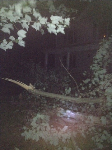
©™2012 Nelson County Life : Photo By Tommy Stafford : The above photo showing treetops blown down here at NCL during the Friday night round of severe thunderstorms.

Nelson County, VA

Updated at 1:20 AM 6.30.12

Nelson EMS Director Jaime Miller tells us her dispatch center was told by CVEC that crews would not come out until 5AM at the earliest. It appears as of this post at 1:20 AM Saturday that the online CVEC companion site showing outages has not been updated to reflect the total outage status. “Our biggest concern right now is making sure people use extreme caution around downed power lines. There are so many down across the county and we have seen people driving over them in some instances.” Miller told us early Saturday morning.

Original Post at 11:23 PM Friday evening June 29, 2012
We are in the dark here tonight at NCL filing this story from our iPhone. As best we can tell everyone in the county is without power and so many trees are down we can’t begin to give the number. Sarah Shelton the manager at Basic Necessities in Nellysford said she counted at least 10 trees or major sized limbs across 151 between their restaurant and Lodebar.

The storm system was not a tornado, though it produced damaging winds that are certainly similar in many respects. The meteorological term is derecho. From NOAA and the NWS:

A derecho (pronounced similar to “deh-REY-cho” in English, or pronounced phonetically as “”) is a widespread, long-lived wind storm that is associated with a band of rapidly moving showers or thunderstorms. Although a derecho can produce destruction similar to that of tornadoes, the damage typically is directed in one direction along a relatively straight swath. As a result, the term “straight-line wind damage” sometimes is used to describe derecho damage. By definition, if the wind damage swath extends more than 240 miles (about 400 kilometers) and includes wind gusts of at least 58 mph (93 km/h) or greater along most of its length, then the event may be classified as a derecho.

You can read more about derechos here.

Here at NCL in Greenfield we have numerous treetops down on the front of the office.

Photo Courtesy of Vickie Hensley : 3 men work to clear tree limbs from the Horseshoe Road near Colleen Friday evening.
Photo Courtesy of Heidi Crandall : Steve Crandall of Roseland, VA helps to clear a large tree from Route 151 Friday night.

Elsewhere in the county just east of Lovingston people were trapped in a home where a tree fell on their house.

Nelson EMS Director Jaime Miller tells us that emergency shelters were opened in both Roseland at the rescue squad and in Lovingston at the firehouse to give people a place to stay that couldn’t make it home.

Greg Kelly with Central Virginia Electric tells us hey are making an assessment now. He tells us it will be a large task making that assessment since so many trees are reported down.

We will update here as often as possible. We are efforting our backup power now and will be back up with all computers soon.

Adventure Challenge Kicks Off Saturday & Sunday At Wintergreen Resort

0
Adventure Challenge is this weekend at Wintergreen Resort!

Wintergreen Resort
Nelson County, VA

Adventure Challenge is here and kicks off this weekend. Over a thousand people will be converging at Wintergreen Resort for the 20 obstacles that will test your physical and mental strength! NCL Publisher, Yvette Stafford will be one of several local people participating in the challenge on Sunday. You may remember her and Team Nelson from other similar events in the past!

Recently we gave away several participant and spectator passes here.

©™ 2012 Nelson County Life : Photo By NCL Mountain Photographer Paul Purpura : The start gate of the Adventure Challenge at Wintergreen Resort can be seen in the distance. Adventure Challenge kicks of Saturday morning June 30th.
The Wintergreen Adventure Challenge features 20 obstacles over a 7 mile terrain. Image courtesy: WintergreenResort.com

The resort describes the challenge like this:

7 mile course
Over a mile of extreme elevation changes
20 obstacles that will test your physical and mental strength
Minimum 18 years of age
First Wave at 8am
Start groups every 20 minutes
Pick your registration time and coordinate with your friends and teammates

See you on the mountain!

Wintergreen & Nelson : Severe Thunderstorm Watch : !CANCELED!

0
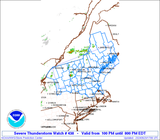
A Severe Thunderstorm Watch continues until 1AM Sunday morning for most of Central VA including Nelson and Wintergreen.

SEVERE THUNDERSTORM WATCH NUMBER 438

If this line of storms holds together coming out of West VA - storms will affect Nelson later tonight.

URGENT – IMMEDIATE BROADCAST REQUESTED
SEVERE THUNDERSTORM WATCH NUMBER 438
NWS STORM PREDICTION CENTER NORMAN OK
635 PM EDT FRI JUN 29 2012

THE NWS STORM PREDICTION CENTER HAS ISSUED A
SEVERE THUNDERSTORM WATCH FOR PORTIONS OF

DISTRICT OF COLUMBIA
EXTREME EASTERN KENTUCKY
WESTERN MARYLAND
SOUTHWEST PENNSYLVANIA
MUCH OF VIRGINIA
SOUTHERN AND EASTERN WEST VIRGINIA
COASTAL WATERS

EFFECTIVE THIS FRIDAY NIGHT AND SATURDAY MORNING FROM 635 PM
UNTIL 100 AM EDT.

HAIL TO 2 INCHES IN DIAMETER…THUNDERSTORM WIND GUSTS TO 80
MPH…AND DANGEROUS LIGHTNING ARE POSSIBLE IN THESE AREAS.

THE SEVERE THUNDERSTORM WATCH AREA IS APPROXIMATELY ALONG AND 110
STATUTE MILES NORTH AND SOUTH OF A LINE FROM 35 MILES SOUTH OF
PARKERSBURG WEST VIRGINIA TO 45 MILES NORTH NORTHEAST OF RICHMOND
VIRGINIA. FOR A COMPLETE DEPICTION OF THE WATCH SEE THE
ASSOCIATED WATCH OUTLINE UPDATE (WOUS64 KWNS WOU8).

REMEMBER…A SEVERE THUNDERSTORM WATCH MEANS CONDITIONS ARE
FAVORABLE FOR SEVERE THUNDERSTORMS IN AND CLOSE TO THE WATCH
AREA. PERSONS IN THESE AREAS SHOULD BE ON THE LOOKOUT FOR
THREATENING WEATHER CONDITIONS AND LISTEN FOR LATER STATEMENTS
AND POSSIBLE WARNINGS. SEVERE THUNDERSTORMS CAN AND OCCASIONALLY
DO PRODUCE TORNADOES.

OTHER WATCH INFORMATION…CONTINUE…WW 436…WW 437…

DISCUSSION…FAST MOVING AND DAMAGING DERECHO OVER OH HAS RESULTED
IN WIDESPREAD DAMAGING WINDS. THIS SYSTEM WILL CONTINUE TO TRACK
EAST-SOUTHEASTWARD ACROSS THE WATCH AREA THIS EVENING. STORMS MAY
LOSE SOME INTENSITY AS THEY MOVE ACROSS THE APPALACHIANS…BUT MOIST
AND VERY UNSTABLE AIR MASS OVER VA SUGGESTS THAT THREAT OF AT LEAST
SCATTERED SEVERE WIND GUSTS WILL CONTINUE.

AVIATION…A FEW SEVERE THUNDERSTORMS WITH HAIL SURFACE AND ALOFT
TO 2 INCHES. EXTREME TURBULENCE AND SURFACE WIND GUSTS TO 70
KNOTS. A FEW CUMULONIMBI WITH MAXIMUM TOPS TO 550. MEAN STORM
MOTION VECTOR 30045.

- Advertisement -