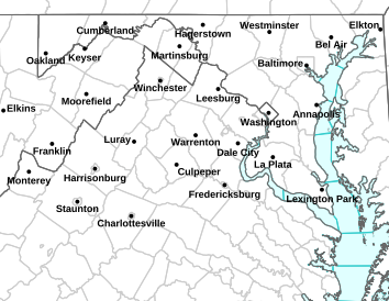
Numerous freeze watchers / warnings and frost advisories are in effect overnight Monday into Tuesday morning. Click on image above for the latest updates.
Winter Weather Statement
Statement as of 8:01 AM EDT on May 14, 2013
…Frost advisory has expired…
Temperatures will quickly warm into the 40s and 50s this morning.
FROST/FREEZE CONDITIONS POSSIBLE TONIGHT AND EARLY TUESDAY URGENT – WEATHER MESSAGE
NATIONAL WEATHER SERVICE BALTIMORE MD/WASHINGTON DC
315 PM EDT MON MAY 13 2013
NELSON-ALBEMARLE-GREENE-MADISON-RAPPAHANNOCK-LOUDOUN-ORANGE-
CULPEPER-NORTHERN FAUQUIER-SOUTHERN FAUQUIER-
INCLUDING THE CITIES OF…CHARLOTTESVILLE…WASHINGTON…
LEESBURG…CULPEPER…WARRENTON
315 PM EDT MON MAY 13 2013
…FROST ADVISORY IN EFFECT FROM 2 AM TO 8 AM EDT TUESDAY…
THE NATIONAL WEATHER SERVICE IN BALTIMORE MD/WASHINGTON HAS
ISSUED A FROST ADVISORY…WHICH IS IN EFFECT FROM 2 AM TO 8 AM
EDT TUESDAY.
* TEMPERATURES…MIDDLE 30S EARLY TUESDAY MORNING.
* IMPACTS…POTENTIAL DAMAGE TO UNPROTECTED COLD-SENSITIVE
VEGETATION.
PRECAUTIONARY/PREPAREDNESS ACTIONS…
A FROST ADVISORY MEANS THAT FROST IS POSSIBLE. SENSITIVE OUTDOOR
PLANTS MAY BE KILLED IF LEFT UNCOVERED.
URGENT – WEATHER MESSAGE
NATIONAL WEATHER SERVICE BLACKSBURG VA
400 PM EDT MON MAY 13 2013
…FROST/FREEZE CONDITIONS POSSIBLE TONIGHT AND EARLY TUESDAY…
.AS COLD HIGH PRESSURE SETTLES OVER THE REGION…WE WILL HAVE THE
POTENTIAL AGAIN FOR AREAS WITH LOW TEMPERATURES AT OR BELOW
FREEZING…AND SOME AREAS WITH TEMPERATURES IN THE MID 30S WITH
FROST.
VAZ034-035-045>047-059-140400-
/O.NEW.KRNK.FR.Y.0002.130514T0700Z-130514T1300Z/
BEDFORD-AMHERST-CAMPBELL-APPOMATTOX-BUCKINGHAM-CHARLOTTE-
INCLUDING THE CITIES OF…BEDFORD…AMHERST…LYNCHBURG…
APPOMATTOX…KEYSVILLE
400 PM EDT MON MAY 13 2013
…FROST ADVISORY IN EFFECT FROM 3 AM TO 9 AM EDT TUESDAY…
THE NATIONAL WEATHER SERVICE IN BLACKSBURG HAS ISSUED A FROST
ADVISORY…WHICH IS IN EFFECT FROM 3 AM TO 9 AM EDT TUESDAY.
* LOCATIONS… AREAS NORTH OF THE ROANOKE RIVER VALLEY AND EAST
OF ROUGHLY LEXINGTON TO BEDFORD.
* HAZARDS…AREAS OF FROST
* TEMPERATURES…IN THE MID 30S.
* TIMING…PRIMARILY 500 AM TO 800 AM.
* IMPACTS…SENSITIVE PLANTS MAY BE DAMAGED OR KILLED.
PRECAUTIONARY/PREPAREDNESS ACTIONS…
A FROST ADVISORY MEANS THAT FROST IS POSSIBLE. SENSITIVE OUTDOOR
PLANTS MAY BE KILLED IF LEFT UNCOVERED.
BlueRidgeLife™2013 – Photos By BRLM Mountain Photographer Paul Purpura : Every kind of car imaginable was on hand this past Saturday at The Waynesboro Motorsports show held May 11, 2013 in Constitution Park.
Waynesboro
Augusta County, VA
As far as the eye could see, autos from every category and every time period were on display this past Saturday – May 11, 2013 at the Waynesboro Motorsports Show. Our Mountain Photographer Paul Purpura headed over to grab some fantastic shots of some really pretty cars, and trucks! The annual show is part of the Waynesboro Downtown Development.
Here’s the winners:
Best In Show Cars
Bill Horn, Stuarts Draft
2012 Ford Mustang Shelby GT 500
Valley Mustangs Unlimited
Best In Show Trucks
Robert & Susan Gray, Waynesboro
1929 Model A Ford
Skyline Model A Club
Best In Show Motorcycles
Rudy & Susie Landis, Waynesboro
2008 Honda Goldwing
Celebrity’s Choice
Donnie Sweet & Linda Lipscomb, Stuarts Draft
1970 Plymouth Roadrunner
Shenandoah Valley Mopar Club
To see all of Paul’s pictures from the motorsports show in Waynesboro this past weekend, click on the image above to view our Facebook album.
BlueRidgeLife™2013 : Photos By Paul Purpura : It was tractors and trucks with plenty of horsepower this past Saturday – May 11, 2013 at the Rockfish Valley Volunteer Fire Department Truck & Tractor Pull.
Afton
Nelson County, VA
There was plenty of horsepower this past Saturday – May 11, 2013 at the Rockfish Valley Volunteer Fire & Rescue Truck & Tractor Pull. Our BRLM Mountain Photographer Paul Purpura came down off of the hill to grab a few shots.
To see all of Paul’s shots from the truck & tractor pull, click on the image above to head on over to our BRLM Facebook album.
BlueRidgeLife@2013 – Photos By Marcie Gates: A youngster tries out the hula hoop as Jennifer Stuart with The Design gets with the singing in the background at the 2013 Band Fair held at Cardinal Point Vineyard & Winery this past Saturday – May 11, 2013 in Afton, VA.
Afton
Nelson County, VA
Despite the threat of thunderstorms in the afternoon, mother nature cooperated for the most part at Band Fair 2013 held at Cardinal Point Vineyard & Winery in Afton this past Saturday – May 11, 2013. Band Fair is an annual fundraiser that benefits North Branch School.
To see more of Marcie’s pictures from BandFair 2013 head on over to our BRLM Facebook album by clicking on the image above.
Photo Courtesy of Gladstone Volunteer Fire & Rescue: Left to Right – Stephen Rea, Thomas Jefferson EMS Council Executive Director, Jennifer Burks, Gladstone Vol. Fire and Rescue Service, Member, Mary Kathryn Allen, GVF&RS Captain, Jim Allen, GVF&RS member, and Chief Curtis Sheets, Wintergreen F&R and President of TJEMS are all smiles this past Wednesday night – May 8, 2013 after Gladstone Fire & Rescue received Outstanding EMS Agency within the region. The award was presented during a ceremony at the Lake Monticello Fire Department in Fluvanna County. Gladstone is now in the running for the state award in November.
Gladstone
Nelson County, VA
Not long ago Gladstone was going through some dark times. After the old fire & rescue lost it’s charter a couple of years ago after some improprieties discovered, today they have emerged under a new charter and were just named Outstanding EMS Agency within the Thomas Jefferson Emergency Medical Services region. “Our community was in desperate need of local EMS service. The fire dept stepped up and decided to form a combined fire and EMS system,” said Mary Kathryn Allen, a captain with Gladstone Fire & Rescue.
“Gladstone Fire Department reincorporated last year so they could provide EMS services to their remote corner of the County. After the Gladstone Rescue Squad closed, the community of Gladstone went for nearly a year relying upon ambulance responses from Lovingston and beyond. Instead of an “okay we’ll do it” attitude, they charged forward with an attitude of “we’ll do it better.” They licensed the agency as an Advanced Life Support and acquired all of the associated equipment. Until this point, Gladstone had only been served at the Basic Life Support level,” said Curtis Sheets, President of TJEMS. Sheets is also the Chief of Wintergreen Fire & Rescue. He also received outstanding EMS Administrator in the region during the ceremony in Fluvanna County last Wednesday evening.
View Brents Fatal in a larger map According to Nelson County Sheriff David Brooks, one person is dead from an auto vs motorcycle crash near Brents Gap on Route 151 south of Route 664 in Nelson County, VA – Sunday May 12, 2013
Near Brents Gap
Roseland
Nelson County, VA
Around 9:00 PM VSP’s Public Relations Officer Corinne Gellar in Richmond sent us the following information on the Sunday accident. The investigation is ongoing:
“At 12:26 pm, VSP was called to the scene of a 2-vehicle crash on Route 151, less than a mile south of Route 628, in Nelson County. A 2012 Suzuki GSXR 750CC was southbound on Rte 151 when it crossed the double-solid center line and struck a 1999 Chrysler Town & Country minivan head-on. The motorcyclist, Bryan L. Gamber, 35, of Waynesboro, died at the scene. The cause of the crash remains under investigation.”
Original Post from 2:02 EDT 5.12.13 Nelson County Sheriff David Brooks confirms to BRLM that an accident around noon Sunday May 12, 2013 on Route 151 south of Route 664 was a fatality. “Sadly this is a fatal accident,” Sheriff Brooks confirmed early Sunday afternoon.
The accident was roughly one mile south of Route 664 on 151 in the first tight turn working up the mountain.
The Virginia State Police is the lead agency on the investigation. We will have additional details as they are released from VSP in Richmond on Monday.
Photo Courtesy of Eric Kullmann: The James River at Scottsville is running pretty high these days thanks to all of the rain upstream. Eric snapped this shot at the landing where folks normally would park their cars for tubing and rafting during the summer months.
Scottsville, VA
Mother nature has been giving people living near the James River a view seen only when heavy rains drive water levels up. Eric Kullmann of Scottsville sent us the shot above. Normally people drive through that area to park when they’re heading out to tube on the James.
Though chances for rain diminishes a bit Thursday and Friday, there’s still about a 50% chance for afternoon storms with heavy localized rain possible once again.
A new FLOOD WATCH has been issued for much of Central Virginia through Wednesday evening.
FLOOD WATCH
NATIONAL WEATHER SERVICE BALTIMORE MD/WASHINGTON DC
840 AM EDT WED MAY 8 2013
…FLOOD WATCH IN EFFECT THROUGH THIS EVENING…
MDZ501-502-VAZ025>031-036>040-050-051-055>057-501>504-WVZ050-055-
501>506-082045-
/O.NEW.KLWX.FA.A.0003.130508T1240Z-130509T0400Z/
/00000.0.ER.000000T0000Z.000000T0000Z.000000T0000Z.OO/
EXTREME WESTERN ALLEGANY-CENTRAL AND EASTERN ALLEGANY-AUGUSTA-
ROCKINGHAM-SHENANDOAH-FREDERICK VA-PAGE-WARREN-CLARKE-NELSON-
ALBEMARLE-GREENE-MADISON-RAPPAHANNOCK-ORANGE-CULPEPER-STAFFORD-
SPOTSYLVANIA-KING GEORGE-NORTHERN FAUQUIER-SOUTHERN FAUQUIER-
WESTERN HIGHLAND-EASTERN HIGHLAND-HAMPSHIRE-HARDY-WESTERN GRANT-
EASTERN GRANT-WESTERN MINERAL-EASTERN MINERAL-WESTERN PENDLETON-
EASTERN PENDLETON-
INCLUDING THE CITIES OF…FROSTBURG…CUMBERLAND…STAUNTON…
WAYNESBORO…HARRISONBURG…WINCHESTER…FRONT ROYAL…
CHARLOTTESVILLE…WASHINGTON…CULPEPER…FREDERICKSBURG…
WARRENTON…HIGHTOWN…MONTEREY…MOOREFIELD…BAYARD…
MOUNT STORM…PETERSBURG…ELK GARDEN…KEYSER…FORT ASHBY…
CIRCLEVILLE…FRANKLIN
840 AM EDT WED MAY 8 2013
…FLOOD WATCH IN EFFECT THROUGH THIS EVENING…
THE NATIONAL WEATHER SERVICE IN STERLING VIRGINIA HAS ISSUED A
* FLOOD WATCH FOR PORTIONS OF MUCH OF THE NORTH CENTRAL VIRGINA
FOOTHILLS AND PIEDMONT…THE HIGHLANDS OF THE EASTERN WEST
VIRGINIA PANHANDLE AND EXTREME WESTERN MARYLAND.
* THROUGH THIS EVENING
* SLOW MOVING LOW PRESSURE WILL REMAIN OVER THE REGION TODAY.
SCATTERED SHOWERS WITH MODERATE TO HEAVY RAIN ARE EXPECTED TO
DEVELOP AGAIN LATE THIS MORNING AND INTO THE EARLY AFTERNOON
HOURS. ANOTHER ONE TO TWO INCHES OF RAINFALL IS POSSIBLE
TODAY…WITH LOCALLY HIGHER AMOUNTS. SINCE THE GROUND IS ALREADY
SATURATED OVER MANY AREAS AND RIVERS ARE HIGH DUE TO YESTERDAYS
RAINFALL…THERE IS AN ENHANCED FLOODING POTENTIAL THROUGH THIS
EVENING.
* LOCALLY HEAVY RAINFALL MAY CAUSE SMALL STREAMS AND CREEKS TO
RISE OUT OF THEIR BANKS…OVERFLOWING LOW LYING ROADS. DO NOT
EVER DRIVE INTO FLOOD WATERS.
PRECAUTIONARY/PREPAREDNESS ACTIONS…
A FLOOD WATCH MEANS THERE IS A POTENTIAL FOR FLOODING BASED ON
CURRENT FORECASTS.
YOU SHOULD MONITOR LATER FORECASTS AND BE ALERT FOR POSSIBLE
FLOOD WARNINGS. THOSE LIVING IN AREAS PRONE TO FLOODING SHOULD BE
PREPARED TO TAKE ACTION SHOULD FLOODING DEVELOP.
Photo By Jennifer Wright: Heavy hail fell with a severe thunderstorm just after 3PM Tuesday afternoon – May 7, 2013. This is the porch of Jennifer Wright’s home in Shipman, VA.
Shipman
Nelson County, VA
Very intense storms moving across East and Central Nelson County Tuesday afternoon dropped very heavy flooding rains along with hail in many locations.
Photo By Tori Mininger : Tori measured 1/2″ of hail on the ground in Shipman Tuesday afternoon – May 7, 2013.Photo By BRLM Yvette Stafford: Dark storm clouds moved north from south of Nellysford along Route 151 Tuesday afternoon – May 7, 2013.Photo By John Taylor : The same storm clouds as seen in the pic by Yvette above, but as seen looking down from Devils Knob at Wintergreen Resort.Photo By Danny Johnson: Flooding rains cover the street near BB&T Bank in Lovingston Tuesday afternoon – May 7, 2013.Photo By Cliff Oliver: This is Dutch Creek Lane in Shipman. Cliff tells us it is generally only 3-4 feet wide, but flooding rains made it more like a lake Tuesday afternoon – May 7, 2013.
Nelson school students were held at NMS & NCHS until the storms passed before being let on buses to head home.
Many severe thunderstorm warnings along with flood watches and warnings remained in effect late Tuesday.
Via NWS: Flood Watches and other heavy rain related advisories are in effect for most of the area through Tuesday evening. Click on the map above to see the latest.
FLOOD WATCH
FLOOD WATCH
NATIONAL WEATHER SERVICE BALTIMORE MD/WASHINGTON DC
621 PM EDT TUE MAY 7 2013
VAZ025>031-036>040-050-051-501>504-WVZ050-055-502-504>506-080400-
/O.CON.KLWX.FA.A.0002.000000T0000Z-130508T0400Z/
/00000.0.ER.000000T0000Z.000000T0000Z.000000T0000Z.OO/
AUGUSTA-ROCKINGHAM-SHENANDOAH-FREDERICK VA-PAGE-WARREN-CLARKE-
NELSON-ALBEMARLE-GREENE-MADISON-RAPPAHANNOCK-ORANGE-CULPEPER-
NORTHERN FAUQUIER-SOUTHERN FAUQUIER-WESTERN HIGHLAND-
EASTERN HIGHLAND-HAMPSHIRE-HARDY-EASTERN GRANT-EASTERN MINERAL-
WESTERN PENDLETON-EASTERN PENDLETON-
INCLUDING THE CITIES OF…STAUNTON…WAYNESBORO…HARRISONBURG…
WINCHESTER…FRONT ROYAL…CHARLOTTESVILLE…WASHINGTON…
CULPEPER…WARRENTON…HIGHTOWN…MONTEREY…MOOREFIELD…
PETERSBURG…KEYSER…FORT ASHBY…CIRCLEVILLE…FRANKLIN
621 PM EDT TUE MAY 7 2013
…FLOOD WATCH REMAINS IN EFFECT UNTIL MIDNIGHT EDT TONIGHT…
THE FLOOD WATCH CONTINUES FOR
* PORTIONS OF THE POTOMAC HIGHLANDS OF EASTERN WEST VIRGINIA AND
VIRGINIA…CENTRAL AND NORTHERN PORTIONS OF THE SHENANDOAH
VALLEY…AND THE CENTRAL FOOTHILLS OF VIRGINIA.
* UNTIL MIDNIGHT EDT TONIGHT
* A SLOW-MOVING LOW PRESSURE SYSTEM WILL CONTINUE TO CAUSE
MODERATE TO LOCALLY HEAVY RAINFALL THIS EVENING. LOCATIONS NEAR
THE BLUE RIDGE MOUNTAINS AND IN THE CENTRAL SHENANDOAH VALLEY
HAVE ALREADY RECEIVED TWO TO FIVE INCHES OF RAIN. SHOWERS AND
THUNDERSTORMS WILL BE CAPABLE OF PRODUCING AN ADDITIONAL ONE TO
THREE INCHES.
* LOCALLY HEAVY RAINFALL WILL CONTINUE TO CAUSE SMALL STREAMS AND
CREEKS TO RISE OUT OF THEIR BANKS…OVERFLOWING LOW LYING ROADS.
NEVER DRIVE INTO FLOOD WATERS.
PRECAUTIONARY/PREPAREDNESS ACTIONS…
A FLOOD WATCH MEANS THERE IS A POTENTIAL FOR FLOODING BASED ON
CURRENT FORECASTS.
YOU SHOULD MONITOR LATER FORECASTS AND BE ALERT FOR POSSIBLE
FLOOD WARNINGS. THOSE LIVING IN AREAS PRONE TO FLOODING SHOULD BE
PREPARED TO TAKE ACTION SHOULD FLOODING DEVELOP.
&&
$$
FLOOD WATCH
NATIONAL WEATHER SERVICE BALTIMORE MD/WASHINGTON DC
621 PM EDT TUE MAY 7 2013
VAZ055>057-080400-
/O.EXA.KLWX.FA.A.0002.000000T0000Z-130508T0400Z/
/00000.0.ER.000000T0000Z.000000T0000Z.000000T0000Z.OO/
STAFFORD-SPOTSYLVANIA-KING GEORGE-
INCLUDING THE CITY OF…FREDERICKSBURG
621 PM EDT TUE MAY 7 2013
…FLOOD WATCH IN EFFECT UNTIL MIDNIGHT EDT TONIGHT…
THE NATIONAL WEATHER SERVICE IN STERLING VIRGINIA HAS EXPANDED
THE
* FLOOD WATCH TO INCLUDE PORTIONS OF CENTRAL AND NORTHERN VIRGINIA…
INCLUDING KING GEORGE…SPOTSYLVANIA AND STAFFORD COUNTIES.
* UNTIL MIDNIGHT EDT TONIGHT
* A SLOW-MOVING LOW PRESSURE SYSTEM WILL CAUSE MODERATE TO
LOCALLY HEAVY RAINFALL THIS EVENING IN THE NORTHERN PIEDMONT
REGION. SHOWERS AND THUNDERSTORMS WILL BE CAPABLE OF PRODUCING
AN ADDITIONAL ONE TO THREE INCHES.
* LOCALLY HEAVY RAINFALL MAY CAUSE SMALL STREAMS AND CREEKS TO
RISE OUT OF THEIR BANKS…OVERFLOWING LOW LYING ROADS. NEVER DRIVE
INTO FLOOD WATERS.
PRECAUTIONARY/PREPAREDNESS ACTIONS…
A FLOOD WATCH MEANS THERE IS A POTENTIAL FOR FLOODING BASED ON
CURRENT FORECASTS.
YOU SHOULD MONITOR LATER FORECASTS AND BE ALERT FOR POSSIBLE
FLOOD WARNINGS. THOSE LIVING IN AREAS PRONE TO FLOODING SHOULD BE
PREPARED TO TAKE ACTION SHOULD FLOODING DEVELOP.
&&
$$
FLOOD WATCH
NATIONAL WEATHER SERVICE BLACKSBURG VA
346 PM EDT TUE MAY 7 2013
…FLOODING REMAINS POSSIBLE THROUGH MIDNIGHT…
.A SLOW MOVING UPPER LEVEL LOW WILL DRIFT ACROSS NORTH CAROLINA
THIS AFTERNOON AND EVENING…PROVIDING SUPPORT FOR MODERATE TO
OCCASIONALLY HEAVY RAIN ACROSS THE REGION. WHILE BANDS OF
CONTINUOUS RAIN PASS ACROSS AREAS THAT ARE SATURATED FROM
RAINFALL EARLIER TODAY IN THE MOUNTAINS AND FOOTHILLS NORTH OF
INTERSTATE 81…SHOWERS AND THUNDERSTORMS ARE DEVELOPING ACROSS
THE MOUNTAINS SOUTH OF THE INTERSTATE. THESE SHOWERS AND
THUNDERSTORMS WILL BE SLOW MOVING…AND MAY BEGIN TO TRAIN…
PASSING ACROSS THE SAME LOCATIONS REPEATEDLY. RAIN WILL BE HEAVY
AT TIMES THIS AFTERNOON AREAWIDE…BUT ESPECIALLY ALONG THE BLUE
RIDGE…AS WELL AS THE EASTERN FACE OF OTHER PROMINENT RIDGES
ACROSS THE REGION.
VAZ013-014-016>020-022>024-032>035-080400-
/O.CON.KRNK.FA.A.0003.000000T0000Z-130508T0400Z/
/00000.0.ER.000000T0000Z.000000T0000Z.000000T0000Z.OO/
PULASKI-MONTGOMERY-CARROLL-FLOYD-CRAIG-ALLEGHANY VA-BATH-ROANOKE-
BOTETOURT-ROCKBRIDGE-PATRICK-FRANKLIN-BEDFORD-AMHERST-
INCLUDING THE CITIES OF…RADFORD…PULASKI…BLACKSBURG…
GALAX…FLOYD…NEW CASTLE…CLIFTON FORGE…COVINGTON…
HOT SPRINGS…ROANOKE…SALEM…FINCASTLE…LEXINGTON…
BUENA VISTA…STUART…ROCKY MOUNT…BEDFORD…AMHERST
346 PM EDT TUE MAY 7 2013
…FLOOD WATCH REMAINS IN EFFECT UNTIL MIDNIGHT EDT TONIGHT…
THE FLOOD WATCH CONTINUES FOR
* PORTIONS OF CENTRAL VIRGINIA…SOUTH CENTRAL VIRGINIA…
SOUTHWEST VIRGINIA AND WEST CENTRAL VIRGINIA…INCLUDING THE
FOLLOWING AREAS…IN CENTRAL VIRGINIA…AMHERST. IN SOUTH
CENTRAL VIRGINIA…BEDFORD. IN SOUTHWEST VIRGINIA…CARROLL…
CRAIG…FLOYD…MONTGOMERY…PATRICK AND PULASKI. IN WEST
CENTRAL VIRGINIA…ALLEGHANY VA…BATH…BOTETOURT…
FRANKLIN…ROANOKE AND ROCKBRIDGE.
* UNTIL MIDNIGHT EDT TONIGHT
* ADDITIONAL RAINFALL AMOUNTS AROUND AN INCH…WITH LOCALLY
HIGHER AMOUNTS…ARE POSSIBLE ALONG THE CREST OF THE BLUE
RIDGE…AND A HALF OF AN INCH OR SO OVER THE REST OF THE WATCH
AREA.
* THE MAIN THREAT WILL BE FLOODING ALONG CREEKS…STREAMS AND
RIVERS…ALTHOUGH ISOLATED FLASH FLOODING COULD OCCUR ALONG
STEEPER TERRAIN.
PRECAUTIONARY/PREPAREDNESS ACTIONS…
A FLOOD WATCH MEANS THERE IS A POTENTIAL FOR FLOODING BASED ON
CURRENT FORECASTS. YOU SHOULD MONITOR LATER FORECASTS AND BE
ALERT FOR POSSIBLE FLOOD WARNINGS. THOSE LIVING IN AREAS PRONE TO
FLOODING SHOULD BE PREPARED TO TAKE ACTION SHOULD FLOODING
DEVELOP.