


Lovingston
Nelson County, VA
Milder temps than we’ve seen lately made for a pleasant afternoon at the annual Lovingston Christmas Parade held this past Sunday afternoon – December 1, 2013. Our special thanks to Woody Greenberg for shooting and sharing these photos!


View past Christmas parades by clicking here.
See you next year!


Wintergreen Resort
Nelson County, VA
The calendar is barely past Thanksgiving and Wintergreen Resort opened the slopes Saturday for skiing and snowboarding! Yep about two weeks earlier than the projected December 14th opening.
The slopes were packed on Saturday with the same expected on Sunday.
Gets lots more info from here the Mountain Message at Wintergreen.
See you on the slopes!


Nellysford
Nelson County, VA
The Thanksgiving weekend for Clinton Hudson of Cincinnati, Ohio just got a little better! Clinton was in Nelson visiting relatives and friends. He dropped by Zestivities in the Wild Wolf Shopping Plaza Friday and bought a 5 dollar raffle ticket for a mini Big Green Egg. The BGE and it’s accessories are valued at around 460 dollars. Saturday afternoon, BRL Juniorette Publisher Peyton Stafford got the honor of drawing the winning ticket belonging to Clinton!

“It was a way for us to highlight the opening of our Zestivities expansion and to help out the Nelson Almost Home SPCA no kill facility. We raised just under 500 dollars with the tickets, so we’re making up the difference and giving them 500 dollars,” said Don Rich, owner of Zestivities and HomebrewZ. Don laughingly told us his most recent expansion is named 2 & 5/8 ths. They are almost done, but a few final touches remain. No one seemed to mind when we went by!
Congrats to Clinton! We suspect he’ll be cooking up something good real soon!

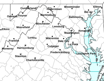
WINTER WEATHER ADVISORY
URGENT – WINTER WEATHER MESSAGE…CORRECTED
NATIONAL WEATHER SERVICE BALTIMORE MD/WASHINGTON DC
648 AM EST TUE NOV 26 2013
AUGUSTA-ROCKINGHAM-SHENANDOAH-FREDERICK VA-PAGE-WARREN-CLARKE-
EASTERN HIGHLAND-JEFFERSON-HARDY-EASTERN PENDLETON-
INCLUDING THE CITIES OF…STAUNTON…WAYNESBORO…HARRISONBURG…
WINCHESTER…FRONT ROYAL…MONTEREY…CHARLES TOWN…MOOREFIELD…
FRANKLIN
648 AM EST TUE NOV 26 2013
…WINTER WEATHER ADVISORY REMAINS IN EFFECT UNTIL 4 PM EST THIS
AFTERNOON…
* PRECIPITATION TYPE…PRECIPITATION WILL START AS A BRIEF PERIOD
OF SNOW AND SLEET THEN QUICKLY CHANGE TO FREEZING RAIN.
* ACCUMULATIONS…LESS THAN AN INCH OF SNOW AND SLEET. UP TO ONE
TENTH OF AN INCH OF FREEZING RAIN.
* TIMING…A LIGHT WINTRY MIX WILL DEVELOP EARLY THIS MORNING…
BEFORE CHANGING OVER TO FREEZING RAIN DURING THE MORNING
COMMUTE. PRECIPITATION WILL CHANGE OVER TO RAIN BUT POCKETS OF
FREEZING RAIN WILL PERSIST THROUGH THIS AFTERNOON.
* TEMPERATURES…IN THE LOWER 30S.
* WINDS…EAST 5 TO 10 MPH.
* IMPACTS…THE COMBINATION OF SNOW…SLEET AND FREEZING RAIN WILL
PRODUCE SLIPPERY CONDITIONS THROUGH THIS EVENING.
PRECAUTIONARY/PREPAREDNESS ACTIONS…
A WINTER WEATHER ADVISORY MEANS THAT PERIODS OF SNOW…SLEET…OR
FREEZING RAIN WILL CAUSE TRAVEL DIFFICULTIES. BE PREPARED FOR
SLIPPERY ROADS AND LIMITED VISIBILITIES…AND USE CAUTION WHILE
DRIVING.
&&
$$
URGENT – WINTER WEATHER MESSAGE…CORRECTED
NATIONAL WEATHER SERVICE BALTIMORE MD/WASHINGTON DC
648 AM EST TUE NOV 26 2013
MDZ009-VAZ036>040-042-501-262015-
/O.CON.KLWX.WW.Y.0031.000000T0000Z-131126T2100Z/
MONTGOMERY-NELSON-ALBEMARLE-GREENE-MADISON-RAPPAHANNOCK-LOUDOUN-
NORTHERN FAUQUIER-
INCLUDING THE CITIES OF…GAITHERSBURG…CHARLOTTESVILLE…
WASHINGTON…LEESBURG…WARRENTON
648 AM EST TUE NOV 26 2013
…WINTER WEATHER ADVISORY REMAINS IN EFFECT UNTIL 4 PM EST THIS
AFTERNOON…
* PRECIPITATION TYPE…PRECIPITATION WILL START AS A BRIEF WINTRY
MIX THEN QUICKLY CHANGING OVER TO FREEZING RAIN.
* ACCUMULATIONS…LESS THAN A HALF INCH OF SNOW AND SLEET. A FEW
HUNDREDTHS OF AN INCH OF ICE…WITH LOCALLY HIGHER AMOUNTS TO
AROUND ONE-TENTH INCH ALONG THE BLUE RIDGE.
* TIMING…A LIGHT WINTRY MIX WILL DEVELOP EARLY THIS MORNING…
BEFORE CHANGING OVER TO FREEZING RAIN DURING THE MORNING
COMMUTE. PRECIPITATION WILL CHANGE OVER TO RAIN BUT POCKETS OF
FREEZING RAIN WILL PERSIST THIS AFTERNOON ALONG THE BLUE RIDGE.
* TEMPERATURES…IN THE LOWER 30S.
* WINDS…SOUTHEAST 5 TO 10 MPH.
* IMPACTS…THE COMBINATION OF SNOW…SLEET AND FREEZING RAIN WILL
PRODUCE SLIPPERY CONDITIONS THROUGH THIS AFTERNOON.
PRECAUTIONARY/PREPAREDNESS ACTIONS…
A WINTER WEATHER ADVISORY MEANS THAT PERIODS OF SNOW…SLEET…OR
FREEZING RAIN WILL CAUSE TRAVEL DIFFICULTIES. BE PREPARED FOR
SLIPPERY ROADS AND LIMITED VISIBILITIES…AND USE CAUTION WHILE
DRIVING.
MOTORISTS SHOULD PREPARE FOR POSSIBLE ICY WEATHER
LYNCHBURG – The Virginia Department of Transportation (VDOT) is encouraging motorists to know the weather and road conditions before driving during the overnight hours of Tuesday and into the early hours of Wednesday morning.
VDOT crews are continuing to monitor the forecast and make plans to respond accordingly. Because the storm is supposed to begin as rain, pre-treating will not take place. However, should icing occur, abrasives will be applied to assist motorists with traction.
VDOT reminds drivers to use caution in winter weather, and;
· Check current weather, road conditions and traffic before traveling
· Slow down and allow for extra time to reach your destination
· Keep a safe distance of at least five seconds behind other vehicles, particularly trucks treating the road
· Be aware of potentially icy areas such as shady spots, bridges and overpasses


Roseland / Beech Grove
Nelson County, VA
Though chilly, it wasn’t bad for the Milestone 5K held at Devils Playground this past Saturday afternoon. The race was more of a fun run for adults and kids with the money going to the Nelson County Pantry. The pantry helps needy families with food throughout the year and especially during the holiday season. The race was also one of several events highlighting the 5 year anniversary of Devils Backbone just across the way from the trails.


Wintergreen Resort
Nelson County, VA
With temps dipping as low as 8 degrees as seen by our BRL Weather Station – The Nature Foundation at Wintergreen, it was perfect to kick off snowmaking at Wintergreen Resort. If Mother Nature cooperates, there will be plenty of areas open at the resort by Thanksgiving. And it does look like things will be staying cold.


As shown from the readings in the above photo, temps were brutally cold Sunday morning just after 8AM. No really significant warmup is head our way over the next 7 days. As a matter of fact, a good chance for winter weather is headed for us around Tuesday night through Wednesday evening. I’ll be talking more about those chances over on my forecast page Sunday evening.
But if there was any doubt, winter is arriving, full force!

RED FLAG WARNING – ENHANCED WILDFIRE THREAT
URGENT – FIRE WEATHER MESSAGE
NATIONAL WEATHER SERVICE BALTIMORE MD/WASHINGTON DC
1051 AM EST SUN NOV 24 2013
DCZ001-MDZ003>007-009>011-013-014-016>018-VAZ025>031-036>040-042-
050>057-501-502-WVZ052-053-242300-
/O.CON.KLWX.FW.W.0003.000000T0000Z-131124T2300Z/
DISTRICT OF COLUMBIA-WASHINGTON-FREDERICK MD-CARROLL-
NORTHERN BALTIMORE-HARFORD-MONTGOMERY-HOWARD-SOUTHERN BALTIMORE-
PRINCE GEORGES-ANNE ARUNDEL-CHARLES-ST. MARYS-CALVERT-AUGUSTA-
ROCKINGHAM-SHENANDOAH-FREDERICK VA-PAGE-WARREN-CLARKE-NELSON-
ALBEMARLE-GREENE-MADISON-RAPPAHANNOCK-LOUDOUN-ORANGE-CULPEPER-
PRINCE WILLIAM/MANASSAS/MANASSAS PARK-FAIRFAX-
ARLINGTON/FALLS CHURCH/ALEXANDRIA-STAFFORD-SPOTSYLVANIA-
KING GEORGE-NORTHERN FAUQUIER-SOUTHERN FAUQUIER-BERKELEY-
JEFFERSON-
1051 AM EST SUN NOV 24 2013
…RED FLAG WARNING REMAINS IN EFFECT UNTIL 6 PM EST THIS EVENING
FOR CENTRAL AND NORTHERN VIRGINIA…THE EXTREME EASTERN PANHANDLE
OF WEST VIRGINIA…SOUTHERN AND CENTRAL MARYLAND AND WASHINGTON
DC…
* HUMIDITY…FALLING TO 25 TO 30 PERCENT THIS AFTERNOON.
* WINDS…NORTHWEST 20 TO 25 MPH WITH GUSTS UP TO 40 MPH.
* FUEL MOISTURE…LESS THAN 8 PERCENT.
PRECAUTIONARY/PREPAREDNESS ACTIONS…
A RED FLAG WARNING MEANS THAT CRITICAL FIRE WEATHER CONDITIONS
ARE EITHER OCCURRING NOW…OR WILL SHORTLY. A COMBINATION OF
STRONG WINDS AND LOW RELATIVE HUMIDITY CAN CONTRIBUTE TO EXTREME
FIRE BEHAVIOR.
&&
$$
URGENT – FIRE WEATHER MESSAGE
NATIONAL WEATHER SERVICE BLACKSBURG VA
417 AM EST SUN NOV 24 2013
…DRY CONDITIONS…GUSTY WINDS AND LOW RELATIVE HUMIDITY
EXPECTED FOR SUNDAY…
.VERY DRY ARCTIC AIR OVER THE AREA TODAY WILL COMBINE WITH STRONG
WINDS AND DRY FUELS. THESE CONDITIONS WOULD SUPPORT THE RAPID
SPREAD OF WILDFIRES.
VAZ018>020-022>024-034-035-241800-
/O.UPG.KRNK.FW.A.0002.131124T1400Z-131124T2300Z/
/O.NEW.KRNK.FW.W.0002.131124T1400Z-131124T2300Z/
CRAIG-ALLEGHANY VA-BATH-ROANOKE-BOTETOURT-ROCKBRIDGE-BEDFORD-
AMHERST-
417 AM EST SUN NOV 24 2013
…RED FLAG WARNING IN EFFECT FROM 9 AM THIS MORNING TO 6 PM EST
THIS EVENING FOR WIND AND LOW RELATIVE HUMIDITY FOR PARTS OF THE
ALLEGHANY HIGHLAND AND ROANOKE VALLEY…
THE NATIONAL WEATHER SERVICE IN BLACKSBURG HAS ISSUED A RED FLAG
WARNING FOR WIND AND LOW RELATIVE HUMIDITY…WHICH IS IN EFFECT
FROM 9 AM THIS MORNING TO 6 PM EST THIS EVENING. THE FIRE WEATHER
WATCH HAS BEEN UPGRADED.
* AFFECTED AREA…IN VIRGINIA…FIRE WEATHER ZONE 018 CRAIG…
FIRE WEATHER ZONE 019 ALLEGHANY VA…FIRE WEATHER ZONE 020
BATH… FIRE WEATHER ZONE 022 ROANOKE…FIRE WEATHER ZONE 023
BOTETOURT… FIRE WEATHER ZONE 024 ROCKBRIDGE…FIRE WEATHER
ZONE 034 BEDFORD AND FIRE WEATHER ZONE 035 AMHERST.
* WINDS…NORTHWEST 10 TO 20 MPH WITH GUSTS UP TO 30 MPH.
* RELATIVE HUMIDITY…20 TO 24 PERCENT.
* IMPACTS…RAPID SPREAD OF WILD FIRES.
PRECAUTIONARY/PREPAREDNESS ACTIONS…
A RED FLAG WARNING MEANS THAT CRITICAL FIRE WEATHER CONDITIONS
ARE EITHER OCCURRING NOW…OR WILL SHORTLY. A COMBINATION OF
STRONG WINDS…LOW RELATIVE HUMIDITY WILL CREATE EXPLOSIVE FIRE
GROWTH POTENTIAL.


