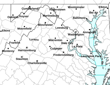
Via NWS: Many Central Virginia Blue Ridge counties are under a Red Flag Warning for increased wildfire danger today until 6PM
Expired and replaced with Fire Weather Watch on Friday. Click Here.
RED FLAG WARNING IN EFFECT FROM 9 AM THIS MORNING TO 6 PM EDT THIS EVENING
ENHANCED POTENTIAL OF FIRE SPREAD TODAY
URGENT – FIRE WEATHER MESSAGE
NATIONAL WEATHER SERVICE BALTIMORE MD/WASHINGTON DC
424 AM EDT THU MAR 13 2014
…ENHANCED POTENTIAL OF FIRE SPREAD TODAY…
NELSON-ALBEMARLE-GREENE-MADISON-RAPPAHANNOCK-LOUDOUN-ORANGE-
CULPEPER-PRINCE WILLIAM/MANASSAS/MANASSAS PARK-FAIRFAX-
ARLINGTON/FALLS CHURCH/ALEXANDRIA-STAFFORD-SPOTSYLVANIA-
KING GEORGE-NORTHERN FAUQUIER-SOUTHERN FAUQUIER-
424 AM EDT THU MAR 13 2014
…RED FLAG WARNING IN EFFECT FROM 9 AM THIS MORNING TO 6 PM EDT
THIS EVENING FOR HIGH WINDS AND LOW HUMIDITY FOR NORTHERN AND
CENTRAL VIRGINIA EAST OF THE BLUE RIDGE…
THE NATIONAL WEATHER SERVICE IN STERLING VIRGINIA HAS ISSUED A
RED FLAG WARNING FOR HIGH WINDS AND LOW HUMIDITY…WHICH IS IN EFFECT
FROM 9 AM THIS MORNING TO 6 PM EDT THIS EVENING. THE FIRE WEATHER
WATCH IS NO LONGER IN EFFECT.
* HUMIDITY…20 TO 25 PERCENT.
* WINDS…NORTHWEST 15 TO 25 MPH WITH GUSTS UP TO 45 MPH.
* FUEL MOISTURE…LESS THAN 10 PERCENT.
PRECAUTIONARY/PREPAREDNESS ACTIONS…
A RED FLAG WARNING MEANS THAT CRITICAL FIRE WEATHER CONDITIONS
ARE EITHER OCCURRING NOW…OR WILL SHORTLY. A COMBINATION OF
STRONG WINDS…LOW RELATIVE HUMIDITY…AND WARM TEMPERATURES CAN
CONTRIBUTE TO EXTREME FIRE BEHAVIOR.
Amherst South: HIGH WIND WARNING IN EFFECT FROM NOON TODAY TO NOON EDT THURSDAY
Nelson North: WIND ADVISORY IN EFFECT WEDNESDAY EVENING THROUGH THURSDAY MORNING
URGENT – WEATHER MESSAGE
NATIONAL WEATHER SERVICE BLACKSBURG VA
340 AM EDT WED MAR 12 2014
…STRONG DAMAGING WINDS LIKELY THIS AFTERNOON THROUGH THURSDAY
MORNING…
.A VERY STRONG COLD FRONT WILL CROSS THROUGH THE REGION LATER THIS
AFTERNOON INTO EARLY THIS EVENING. A QUICK SURGE IN ARCTIC AIR
FOLLOWING THE FRONT WILL COMBINE WITH A STRONG PRESSURE GRADIENT
TO RESULT IN VERY GUSTY…PERHAPS DAMAGING NORTHWEST WINDS.
ASHE-ALLEGHANY NC-SURRY-WATAUGA-WILKES-TAZEWELL-SMYTH-BLAND-GILES-
WYTHE-PULASKI-MONTGOMERY-GRAYSON-CARROLL-FLOYD-CRAIG-ALLEGHANY VA-
ROANOKE-BOTETOURT-ROCKBRIDGE-PATRICK-FRANKLIN-BEDFORD-AMHERST-
MONROE-
INCLUDING THE CITIES OF…WEST JEFFERSON…SPARTA…DOBSON…
BOONE…WILKESBORO…TAZEWELL…MARION…BLAND…PEARISBURG…
WYTHEVILLE…RADFORD…PULASKI…BLACKSBURG…INDEPENDENCE…
WHITETOP…TROUTDALE…VOLNEY…GALAX…FLOYD…NEW CASTLE…
CLIFTON FORGE…COVINGTON…ROANOKE…SALEM…FINCASTLE…
LEXINGTON…BUENA VISTA…STUART…ROCKY MOUNT…BEDFORD…
AMHERST…UNION
340 AM EDT WED MAR 12 2014
…HIGH WIND WARNING IN EFFECT FROM NOON TODAY TO NOON EDT
THURSDAY…
THE NATIONAL WEATHER SERVICE IN BLACKSBURG HAS ISSUED A HIGH WIND
WARNING…WHICH IS IN EFFECT FROM NOON TODAY TO NOON EDT
THURSDAY. THE HIGH WIND WATCH IS NO LONGER IN EFFECT.
* LOCATIONS…THE MOUNTAINS AND FOOTHILLS OF SOUTHWEST
VIRGINIA… SOUTHEAST WEST VIRGINIA AND NORTHWEST NORTH
CAROLINA.
* WINDS…NORTHWEST 25 TO 35 MPH WITH GUSTS UP TO 65 MPH.
* TIMING…FROM LATE THIS AFTERNOON INTO THURSDAY MORNING.
* IMPACTS…DOWNED TREES AND POWER LINES. HIGH PROFILE VEHICLES
WILL BE SUSCEPTIBLE TO THE STRONGER WIND GUSTS.
PRECAUTIONARY/PREPAREDNESS ACTIONS…
A HIGH WIND WARNING MEANS A HAZARDOUS HIGH WIND EVENT IS EXPECTED
OR OCCURRING. SUSTAINED WIND SPEEDS OF AT LEAST 40 MPH OR GUSTS
OF 58 MPH ARE LIKELY TO CAUSE SPORADIC POWER OUTAGES…FALLEN
TREES…MINOR PROPERTY DAMAGE…AND DANGEROUS DRIVING CONDITIONS
FOR HIGH PROFILE VEHICLES. RESIDENTS SHOULD MOVE UNFASTENED
ITEMS…SUCH AS GARBAGE CANS AND DECK FURNITURE…INDOORS.
URGENT – WEATHER MESSAGE
NATIONAL WEATHER SERVICE BALTIMORE MD/WASHINGTON DC
305 AM EDT WED MAR 12 2014
…WIND ADVISORY IN EFFECT WEDNESDAY EVENING THROUGH THURSDAY
MORNING…
DISTRICT OF COLUMBIA-WASHINGTON-FREDERICK MD-CARROLL-
NORTHERN BALTIMORE-HARFORD-MONTGOMERY-HOWARD-SOUTHERN BALTIMORE-
PRINCE GEORGES-ANNE ARUNDEL-CHARLES-ST. MARYS-CALVERT-
EXTREME WESTERN ALLEGANY-CENTRAL AND EASTERN ALLEGANY-AUGUSTA-
ROCKINGHAM-SHENANDOAH-FREDERICK VA-PAGE-WARREN-CLARKE-NELSON-
ALBEMARLE-GREENE-MADISON-RAPPAHANNOCK-LOUDOUN-CULPEPER-
PRINCE WILLIAM/MANASSAS/MANASSAS PARK-FAIRFAX-
ARLINGTON/FALLS CHURCH/ALEXANDRIA-NORTHERN FAUQUIER-
SOUTHERN FAUQUIER-WESTERN HIGHLAND-EASTERN HIGHLAND-HAMPSHIRE-
MORGAN-BERKELEY-JEFFERSON-HARDY-WESTERN GRANT-EASTERN GRANT-
WESTERN MINERAL-EASTERN MINERAL-WESTERN PENDLETON-
EASTERN PENDLETON-
INCLUDING THE CITIES OF…WASHINGTON…HAGERSTOWN…FREDERICK…
WESTMINSTER…GAITHERSBURG…COLUMBIA…BALTIMORE…ANNAPOLIS…
WALDORF…ST MARYS CITY…FROSTBURG…CUMBERLAND…STAUNTON…
WAYNESBORO…HARRISONBURG…WINCHESTER…FRONT ROYAL…
CHARLOTTESVILLE…LEESBURG…CULPEPER…MANASSAS…
MANASSAS PARK…FAIRFAX…ALEXANDRIA…FALLS CHURCH…WARRENTON…
HIGHTOWN…MONTEREY…MARTINSBURG…CHARLES TOWN…MOOREFIELD…
BAYARD…MOUNT STORM…PETERSBURG…ELK GARDEN…KEYSER…
FORT ASHBY…CIRCLEVILLE…FRANKLIN
305 AM EDT WED MAR 12 2014
…WIND ADVISORY IN EFFECT FROM 6 PM THIS EVENING TO 11 AM EDT
THURSDAY…
THE NATIONAL WEATHER SERVICE IN BALTIMORE MD/WASHINGTON HAS
ISSUED A WIND ADVISORY…WHICH IS IN EFFECT FROM 6 PM THIS
EVENING TO 11 AM EDT THURSDAY.
* TIMING…WEDNESDAY EVENING THROUGH THURSDAY MORNING.
* WINDS…NORTHWEST 20 TO 30 MPH WITH GUSTS UP TO 50 MPH.
* IMPACTS…SCATTERED TREE AND POWER LINE DAMAGE. DIFFICULTY
DRIVING HIGH PROFILE VEHICLES.
PRECAUTIONARY/PREPAREDNESS ACTIONS…
A WIND ADVISORY MEANS THAT WIND GUSTS OF 45 TO 55 MPH ARE
EXPECTED. SECURE OUTDOOR FURNITURE AND TAKE CARE DRIVING HIGH
PROFILE VEHICLES.
Lovingston
Nelson County, VA
The musical production of Grease ended as a huge success this past weekend at Nelson County High in Lovingston. Students with the drama department there cranked out several nights of the musical including a Sunday afternoon show as the finale. All of this in spite of Old Man Winter trying to put a stop to it with an early March snow.
Danny (Drew McCarter) tells the rest of the Greasers about the girl he met over the summerThe famous Drive Inn scene between Danny and Sandy.To see all of the pics from Paul’s shoot of Grease, click on the photo above to head on over to his gallery. He’s got dozens more shots over there to view!
Wintergreen
Nelson County, VA
A week long celebration of events was capped off this past Saturday – March 8, 2014 as the folks at The Nature Foundation At Wintergreen held a pancake breakfast using maple syrup harvested within the past few days from trees on the mountain. After breakfast people got the chance to go on a Sugarbush Sojourn taking a winter hike to Wintergreen’s sugarbushes. They saw first-hand the old-fashioned and new-fangled ways of collecting maple sap.
We first told you about the neat story of tapping the maple trees in our April 2010 issue of (then) Nelson County Life Magazine. Click above to read more about that.
These ladies taste what will eventually become maple syrup this past Saturday – March 8, 2013 at The Nature Foundation at Wintergreen.Diners enjoyed authentic maple syrup over their pancakes this past Saturday – March 8, 2013.Sap from maple trees that will eventually become syrup, boils in pots outside The Nature Foundation At Wintergreen this past Saturday – March 8, 2014
Paul tells us, “The sap as is comes out of the tree is clear and has the consistency of water. If you taste it (as I did) you will find it that it is just a hint of sweetness. As the sap is boiled over an extended period (about 8 hours) it then becomes the maple syrup we are all familiar with.”
Here’s our exclusive weather station at The Nature Foundation At Wintergreen. BRL in a partnership with The Nature Foundation maintains the station on Devils Knob, 24 hours a day, 7 days a week since 2007. Click on the graphic above to see more details from that station.
Daylight Saving Time Begins This Sunday Morning. Move Your Clock Forward One Hour Before Bed Saturday Night.
Central Virginia Blue Ridge
With the exception of a couple of places in the US, you’ll need to spring forward one hour before bedtime Saturday night. Daylight Saving Time begins at 2AM Sunday morning, so unless you are a total night owl you’ll want to make the clock adjustment as you turn in for bed Saturday.
The time stays that way until Sunday – November 2nd 2014 when we fall back again for the coming winter.
Enjoy your extra daylight as we look forward to those long summer days ahead!
Central Virginia Blue Ridge
As predicted a winter storm arrived in a major way Monday morning. By 8AM most roads across the area were completely covered in snow and ice with countless accidents happening all across the area.
Above this was the scene at an accident along Route 151 near Martins Store. You can see a truck over the embankment (left side) in the beginning of the video from the dashcam.
Snow, heavy at times, will continue falling through out the day with significant accumulations throughout the afternoon.
Via: A WINTER STORM WARNING has been issued for virtually all of the Virginia including the Central Virginia Blue Ridge.
CANCELED – CANCELED – CANCELED – CANCELED
WINTER STORM WARNING IN EFFECT FROM 3 AM TO 9 PM EST MONDAY URGENT – WINTER WEATHER MESSAGE
NATIONAL WEATHER SERVICE BALTIMORE MD/WASHINGTON DC
240 AM EST MON MAR 3 2014
CHARLES-ST. MARYS-CALVERT-NELSON-ALBEMARLE-ORANGE-STAFFORD-
SPOTSYLVANIA-KING GEORGE-
INCLUDING THE CITIES OF…WALDORF…ST MARYS CITY…
CHARLOTTESVILLE…FREDERICKSBURG
240 AM EST MON MAR 3 2014
…WINTER STORM WARNING REMAINS IN EFFECT UNTIL 9 PM EST THIS
EVENING…
* PRECIPITATION TYPE…FREEZING RAIN…SLEET…AND HEAVY SNOW.
* ACCUMULATIONS…UP TO ONE TENTH INCH OF ICE…THEN 6 TO 10
INCHES OF SNOW.
* TIMING…RAIN WILL CHANGE TO FREEZING RAIN AND SLEET LATE
TONIGHT… THEN WILL CHANGE TO HEAVY SNOW THIS MORNING AND
CONTINUE THROUGH EARLY EVENING.
* TEMPERATURES…DROPPING FROM THE LOWER 30S LATE TONIGHT INTO
THE MID 20S MONDAY.
* WINDS…NORTH 10 TO 15 MPH. GUSTS TO 25 MPH LATE TONIGHT AND
MONDAY.
* IMPACTS…HAZARDOUS TRAVEL DUE TO ICE AND SNOW OVERNIGHT AND
MONDAY. BOTH THE MONDAY MORNING AND AFTERNOON RUSH HOURS WILL
BE AFFECTED. POWER OUTAGES ARE POSSIBLE WITH THE COMBINATION
OF ICE AND HEAVY SNOW.
PRECAUTIONARY/PREPAREDNESS ACTIONS…
THIS WINTER STORM WARNING IS FOR HEAVY SNOW…SLEET…AND
FREEZING RAIN AND MEANS SEVERE WINTER WEATHER CONDITIONS ARE
EXPECTED. SIGNIFICANT AMOUNTS OF ICE AND SNOW ARE FORECAST THAT
WILL MAKE TRAVEL DANGEROUS AND POTENTIALLY CAUSE POWER OUTAGES.
ONLY TRAVEL IN AN EMERGENCY. IF YOU MUST TRAVEL…KEEP AN EXTRA
FLASHLIGHT… FOOD…AND WATER IN YOUR VEHICLE IN CASE OF AN
EMERGENCY.
URGENT – WINTER WEATHER MESSAGE
NATIONAL WEATHER SERVICE BALTIMORE MD/WASHINGTON DC
240 AM EST MON MAR 3 2014
DISTRICT OF COLUMBIA-PRINCE GEORGES-ANNE ARUNDEL-AUGUSTA-
ROCKINGHAM-GREENE-MADISON-CULPEPER-
PRINCE WILLIAM/MANASSAS/MANASSAS PARK-FAIRFAX-
ARLINGTON/FALLS CHURCH/ALEXANDRIA-SOUTHERN FAUQUIER-
WESTERN HIGHLAND-EASTERN HIGHLAND-WESTERN PENDLETON-
EASTERN PENDLETON-
INCLUDING THE CITIES OF…WASHINGTON…ANNAPOLIS…STAUNTON…
WAYNESBORO…HARRISONBURG…CULPEPER…MANASSAS…MANASSAS PARK…
FAIRFAX…ALEXANDRIA…FALLS CHURCH…HIGHTOWN…MONTEREY…
CIRCLEVILLE…FRANKLIN
240 AM EST MON MAR 3 2014
…WINTER STORM WARNING REMAINS IN EFFECT UNTIL 6 PM EST THIS
EVENING…
* PRECIPITATION TYPE…FREEZING RAIN…SLEET…AND HEAVY SNOW.
* ACCUMULATIONS…UP TO ONE TENTH INCH OF ICE…THEN 6 TO 10
INCHES OF SNOW…LOCALLY HIGHER AMOUNTS AROUND 12 INCHES IN
THE POTOMAC HIGHLANDS.
* TIMING…RAIN CHANGES TO FREEZING RAIN AND SLEET FROM NORTH TO
SOUTH…BECOMING HEAVY SNOW LATE TONIGHT AND CONTINUING THROUGH
MONDAY.
* TEMPERATURES…DROPPING INTO THE MID 20S LATE TONIGHT…THEN
LOWER 20S MONDAY.
* WINDS…NORTH 10 TO 15 MPH. GUSTS UP TO 25 MPH LATE TONIGHT
AND MONDAY.
* IMPACTS…HAZARDOUS TRAVEL DUE TO ICE AND SNOW OVERNIGHT AND
MONDAY. BOTH THE MONDAY MORNING AND AFTERNOON RUSH HOURS WILL
BE AFFECTED. POWER OUTAGES ARE POSSIBLE WITH THE COMBINATION
OF ICE AND HEAVY SNOW.
PRECAUTIONARY/PREPAREDNESS ACTIONS…
THIS WINTER STORM WARNING IS FOR HEAVY SNOW…SLEET…AND
FREEZING RAIN AND MEANS SEVERE WINTER WEATHER CONDITIONS ARE
EXPECTED. SIGNIFICANT AMOUNTS OF ICE AND SNOW ARE FORECAST THAT
WILL MAKE TRAVEL DANGEROUS AND POTENTIALLY CAUSE POWER OUTAGES.
ONLY TRAVEL IN AN EMERGENCY. IF YOU MUST TRAVEL…KEEP AN EXTRA
FLASHLIGHT… FOOD…AND WATER IN YOUR VEHICLE IN CASE OF AN
EMERGENCY.
URGENT – WINTER WEATHER MESSAGE
NATIONAL WEATHER SERVICE BLACKSBURG VA
401 AM EST MON MAR 3 2014
…COLD AIR TO CHANGE RAIN TO A QUICK ICY MIX THEN SNOW EARLY
THIS MORNING…
.AN ARCTIC FRONT WILL SLIP SOUTH OF US TODAY. AREAS OF LOW
PRESSURE WILL TRAVEL ALONG THIS FRONT WITH PRECIPITATION CHANGING
FROM RAIN…TO AN ICY MIX…TO SNOW BY MID MORNING. THE MAIN
UPPER LEVEL SYSTEM WILL HEAD EAST AND PRECIPITATION ENDS FROM
WEST TO EAST MONDAY AFTERNOON.
VAZ018-022>024-034-035-045>047-059-031715-
/O.CON.KRNK.WS.W.0005.140303T1200Z-140304T0000Z/ CRAIG-ROANOKE-BOTETOURT-ROCKBRIDGE-BEDFORD-AMHERST-CAMPBELL-
APPOMATTOX-BUCKINGHAM-CHARLOTTE-
INCLUDING THE CITIES OF…NEW CASTLE…ROANOKE…SALEM…
FINCASTLE…LEXINGTON…BUENA VISTA…BEDFORD…AMHERST…
LYNCHBURG…APPOMATTOX…KEYSVILLE
401 AM EST MON MAR 3 2014
…WINTER STORM WARNING REMAINS IN EFFECT FROM 7 AM THIS MORNING
TO 7 PM EST THIS EVENING…
* HAZARD TYPES…HEAVY SNOW AND SLEET.
* ACCUMULATIONS…SNOW ACCUMULATIONS OF 4 TO 8 INCHES NEAR HIGHWAY
460…INCREASING TO 6 TO 10 INCHES ALONG AND NORTH OF THE JAMES
RIVER. SLEET ACCUMULATIONS LESS THAN ONE INCH.
* TIMING…RAIN WILL CHANGE TO SLEET AND SNOW AROUND DAYBREAK
MONDAY…AND TO ALL SNOW BY 11 AM.
* IMPACTS…ROADS WILL BECOME SLICK AND HAZARDOUS. SOME POWER
OUTAGES ARE POSSIBLE.
* WINDS…NORTHEAST 5 TO 15 MPH WITH GUSTS UP TO 25 MPH.
* TEMPERATURES…FALLING INTO THE LOWER 20S DURING THE AFTERNOON.
PRECAUTIONARY/PREPAREDNESS ACTIONS…
A WINTER STORM WARNING FOR HEAVY SNOW MEANS SEVERE WINTER WEATHER
CONDITIONS ARE EXPECTED OR OCCURRING. SIGNIFICANT AMOUNTS OF SNOW
ARE FORECAST THAT WILL MAKE TRAVEL DANGEROUS. ONLY TRAVEL IN AN
EMERGENCY. IF YOU MUST TRAVEL…KEEP AN EXTRA FLASHLIGHT…FOOD…
AND WATER IN YOUR VEHICLE IN CASE OF AN EMERGENCY.
THE PUBLIC IS ENCOURAGED TO REPORT SNOW SLEET AND ICE
ACCUMULATIONS TO THE NATIONAL WEATHER SERVICE VIA EMAIL AT
RNK.SKYWARN@NOAA.GOV OR AT PHONE NUMBER 1…8 6 6…2 1 5…
4 3 2 4.FOR ADDITIONAL WEATHER INFORMATION…VISIT US ON THE WEB
AT HTTP://WWW.ERH.NOAA.GOV OR AT HTTP://WEATHER.GOV. ALSO REPORTS
CAN BE SENT TO OUR FACEBOOK AND TWITTER PAGES.
Central Virginia Blue Ridge Updated 4PM 3.2.14
Here’s the latest thinking on snowfall projections via Virginia Weather Network:
Richmond and Central Virginia has made it up to 70 degrees in spots this afternoon. I hope you enjoyed today, because you will be freezing tomorrow.
A cold front will cross the area Late Sunday and into the early morning hours on Sunday… with low pressure riding along the front. The gradient of very warm to very cold will likely spark a real intense burst of precipitation during the day Monday.
One of the biggest concerns will be a FLASH FREEZE. That’s when rain comes ahead of the frontal system and then temperatures drop rapidly below freezing as the colder air moves into the area. This will create chaos on the roadways. Rain would then changeover to sleet and freezing rain. This is a MAJOR concern over Central and Southern Virginia early Monday morning.
We have bumped snow totals up across Southern Virginia and Hampton roads from 1 to 3 inches, now 2 to 4 inches. Colder air seems to be working in a bit faster on the latest model data, so the changeover to sleet could even happen before Noon across the Southern counties. It will likely be rain around sunrise, but by mid-morning its sleet and freezing rain, then snow in the afternoon.
Tri-Cities is now in 4 to 6 inches of snow accumulation. Rain to freezing rain during the morning commute to sleet. Snow, heavy at times in the afternoon.
The most significant change in this forecast is an area of 6 to 9 inches that extends from Roanoke, Lynchburg, Farmville and right into Central Virginia. The transition from rain to sleet and freezing rain could happen BEFORE Sunrise Monday morning and then SNOW before the Noon hour, with several hours of moderate to heavy snow through early evening.
Charlottesville to Fredericksburg areas remain in the highest snow totals, anywhere from 9 to 12 inches. However, there could be locally higher amounts as labeled on the map of more than a foot. This area is expected to see mostly snow. Some sleet and freezing rain before Sunrise, but it will be very brief.
Far Northern Virginia and Washington D.C. has been bumped down a bit, but will still see a respectful amount of snow anywhere from 6 to 9 inches. Locally higher amounts up to 10 will still be possible.
SOIL TEMPERATURES are warmer because of the milder period we’ve been experiencing today, but quickly freezing temperatures will freeze the ground rather quickly for quickly accumulating ice and snow.
SUN ANGLE this time of year is pretty high, compared to October. Even through overcast conditions, you can get the slightest sun peaking through. Normally this HELPS roadways and keeps them wet and not white. However, with the flash freeze conditions and quickly dropping temperatures throughout the day, this will not help at all. The afternoon/evening commute will likely be a nightmare across much of the State. Tuesday’s morning commute will also be nasty as well with low temperatures dropping into the single digits and teens.
NORFOLK/HAMPTON ROADS
2 to 4 inches…. 2″ coastal… 4″ inland
EASTERN SHORE
2 to 4 inches…. Locally higher amounts possible of 5″
SOUTH HILL – DANVILLE – SOUTHERN VIRGINIA
2 to 4 inches…. closer to 2 along the NC/VA State line.
WILLIAMSBURG – GLOUCESTER
4 to 6″
TRI-CITIES – BLACKSTONE
5 to 7 inches
METRO RICHMOND – GOOCHLAND – ASHLAND
6 to 9 inches
NORTHERN NECK
5 to 8 inches…. lower end immediate coastal areas.
MIDDLE PENINSULA
4 to 7 inches…. lower end immediate coastal areas.
LYNCHBURG – ROANOKE – NEW RIVER VALLEY
6 to 8″
WYTHEVILLE – ABINGDON
3 to 6 inches… locally higher possible
HIGHLANDS
9 to 12 inches… locally higher possible
FREDERICKSBURG – CAROLINE – STAFFORD
9 to 12 inches… locally higher possible
CHARLOTTESVILLE – HARRISONBURG
9 to 12 inches… locally higher possible
LURAY – FRONT ROYAL – WINCHESTER
9 to 12 inches… locally higher possible
CULPEPER – WARRENTON – WASHINGTON METRO
7 to 10 inches
Original post from 3.1.14 Another round of winter weather with significant icing and snowfall is shaping up for a large part of Virginia including the Central Virginia Blue Ridge. The most likely time for the messy weather to begin is after midnight Sunday night into Monday.
Our friends at virginiaweathernetwork.com have been studying what the storm will do and the above graphic is their estimate as of 1PM Saturday. I concur and agree this has the potential to be a major storm. Depending on the exact track and where the temps get the coldest early on will depend on the types of precipitation a certain area will see.
Below is VAWX’s analysis as of Saturday afternoon:
UPDATED SNOW FORECAST…. MONDAY
**SIGNIFICANT CHANGES FOR MOST OF THE STATE**
After a very warm day in the 50s and 60s on Sunday, a cold front will cross the area Late Sunday and into the early morning hours on Sunday… with low pressure riding along the front. The gradient of very warm to very cold will likely spark even more precipitation across the area through the day on Monday.
I want to empathize that this is an arctic front with a very arctic airmass. With the snow accumulation, temperatures will be even colder, especially at night. Just to give you an idea… Most models have temperatures dropping to near ZERO Tuesday Morning across Richmond with many negative numbers North and West. We are talking about a 50+ degree difference in 24 hours.
When it starts snowing hard and temps are below freezing, the snow will stick almost on contact. Even with this mini period of warm temperatures, it will not reduce accumulations at all due to the very cold airmass moving into the area. The colder temperatures working in throughout the day will create higher snow ratios, providing dry, fluffy snow.
There will still be some mixing issues, especially in zones A and B.
Across Southern Virginia and Hampton Roads, these areas will be the last to see a changeover to all snow. Even the 1-3 could be a bit on the conservative side. It will all depend on how much rain falls first, which could create more of a “slush” over wet ground and not accumulate right away.
Across Tri-Cities, it will start as rain early Morning morning, but go over to a mix of freezing rain and sleet for several hours, then snow with snow accumulating quickly through the afternoon.
Richmond Area will see less mixing, probably sleet with MAYBE freezing rain at the onset, but this will probably be mostly sleet and snow, becoming all snow later in the morning and continuing into the afternoon.
Charlottesville to Fredericksburg and points North into Washington Metro will be a mess. It will start as snow and stay snow through the entire event. With temperatures starting on the very cold side and remaining that way, snow ratios will be very high. Locally higher amounts more than a foot would not be surprising at all.
Sun angle needs to be addressed. We are into March now. The sun angle is getting higher. Even through overcast conditions, you can get the slightest sun peaking through. Normally this HELPS roadways and keeps them wet and not white. At first, it will help… However, with hours of steady moderate to heavy snow, roads will become very slick, snow covered and treacherous…especially going into the afternoon and evening from Richmond and points South. Richmond and points North and West roads will probably become slick in the morning hours because the precipitation starts out as snow in these areas. Temperatures below freezing will cause anything that falls to freeze on the roadways. Tuesday morning commute will probably be really bad for at least 80 percent of the State.
Here is a more “narrow” range of what to expect in your area. Out of the most absolute respect, we do not have time to answer your questions on how much snow. Please try to find your location on the map, or use the following pinpoints below for an estimation for your area. Just pick the nearest City/town….. Also on the snow map, with the ranges, the southern end of each zone you go by the lesser number and the higher number on the most northern end of the zone.
NORFOLK/HAMPTON ROADS
1 to 3″….. but 2 to 4″ possible well inland
EASTERN SHORE
1 to 3″
SOUTH HILL – DANVILLE – SOUTHERN VIRGINIA
1 to 3″ near the NC line…. 2 to 4″ North
WILLIAMSBURG – GLOUCESTER
3 to 5″
TRI-CITIES – BLACKSTONE – FARMVILLE
4 to 6″
METRO RICHMOND – GOOCHLAND – ASHLAND
6 to 8″
NORTHERN NECK
3 to 5″ lower Northern Neck…. 5 to 8″ Upper Northern Neck
MIDDLE PENINSULA
3 to 5 lower Peninsula…. 6″+ Well inland
LYNCHBURG – ROANOKE – NEW RIVER VALLEY
5 to 8″
WYTHEVILLE – ABINGDON
3 to 5″…. 6″+ higher elevations
HIGHLANDS
6 – 10″… locally higher in highest elevations
FREDERICKSBURG – CAROLINE – STAFFORD
8 to 10″
CHARLOTTESVILLE – HARRISONBURG
9 to 11″… Locally 12″
LURAY – FRONT ROYAL – WINCHESTER
10 to 12″…. Locally 14″
CULPEPER – WARRENTON – WASHINGTON METRO
10 to 12″…. Locally 14″
Via NWS: Most Counties in Central Virginia are under a WINTER STORM WATCH that begins Sunday evening through Monday afternoon. : Significant snow and ice accumulations are possible.
The Winter Storm Watch is no longer in effect. It has been replaced by this WINTER STORM WARNING.
Previous post WINTER STORM WATCH REMAINS IN EFFECT FROM LATE SUNDAY NIGHT THROUGH MONDAY AFTERNOON URGENT – WINTER WEATHER MESSAGE
NATIONAL WEATHER SERVICE BALTIMORE MD/WASHINGTON DC
937 PM EST SAT MAR 1 2014
DISTRICT OF COLUMBIA-MONTGOMERY-HOWARD-SOUTHERN BALTIMORE-
PRINCE GEORGES-ANNE ARUNDEL-CHARLES-ST. MARYS-CALVERT-AUGUSTA-
ROCKINGHAM-SHENANDOAH-PAGE-WARREN-CLARKE-NELSON-ALBEMARLE-GREENE-
MADISON-RAPPAHANNOCK-LOUDOUN-ORANGE-CULPEPER-
PRINCE WILLIAM/MANASSAS/MANASSAS PARK-FAIRFAX-
ARLINGTON/FALLS CHURCH/ALEXANDRIA-STAFFORD-SPOTSYLVANIA-
KING GEORGE-NORTHERN FAUQUIER-SOUTHERN FAUQUIER-WESTERN HIGHLAND-
EASTERN HIGHLAND-WESTERN PENDLETON-EASTERN PENDLETON-
INCLUDING THE CITIES OF…WASHINGTON…GAITHERSBURG…COLUMBIA…
BALTIMORE…ANNAPOLIS…WALDORF…ST MARYS CITY…STAUNTON…
WAYNESBORO…HARRISONBURG…FRONT ROYAL…CHARLOTTESVILLE…
LEESBURG…CULPEPER…MANASSAS…MANASSAS PARK…FAIRFAX…
ALEXANDRIA…FALLS CHURCH…FREDERICKSBURG…WARRENTON…
HIGHTOWN…MONTEREY…CIRCLEVILLE…FRANKLIN
937 PM EST SAT MAR 1 2014
…WINTER STORM WATCH REMAINS IN EFFECT FROM LATE SUNDAY NIGHT
THROUGH MONDAY AFTERNOON…
* ACCUMULATIONS…POTENTIAL FOR FIVE OR MORE INCHES OF SNOW AND
SLEET WITH SOME ICE ACCUMULATION FROM FREEZING RAIN ALSO
POSSIBLE.
* TIMING…FREEZING RAIN AND SLEET LOOKS TO BEGIN OVERNIGHT
SUNDAY WITH SNOW…HEAVY AT TIMES…LATE SUNDAY NIGHT THROUGH
MONDAY.
* TEMPERATURES…IN THE LOWER 30S OVERNIGHT SUNDAY…FALLING INTO
THE TEENS AND LOWER 20S FOR MONDAY.
* WINDS…NORTH 5 TO 15 MPH WITH GUSTS UP TO 25 MPH.
* IMPACTS…POTENTIAL FOR HAZARDOUS TRAVEL DUE TO ICE AND SNOW
SUNDAY EVENING THROUGH MONDAY. BOTH THE MONDAY MORNING AND
MONDAY AFTERNOON RUSH HOURS WOULD BE AFFECTED.
PRECAUTIONARY/PREPAREDNESS ACTIONS…
A WINTER STORM WATCH MEANS THERE IS A POTENTIAL FOR SIGNIFICANT
SNOW…SLEET…AND ICE ACCUMULATIONS THAT MAY IMPACT TRAVEL.
CONTINUE TO MONITOR THE LATEST FORECASTS.
URGENT – WINTER WEATHER MESSAGE
NATIONAL WEATHER SERVICE BLACKSBURG VA
953 PM EST SAT MAR 1 2014
…SIGNIFICANT SNOWFALL POSSIBLE LATE SUNDAY NIGHT AND MONDAY…
.A WEST TO EAST ORIENTED ARCTIC FRONT WILL SAG SLOWLY SOUTH INTO
THE REGION SUNDAY NIGHT…REACHING THE GREENBRIER VALLEY AROUND
MIDNIGHT…THEN MOVING SOUTHWARD TOWARD THE NORTH CAROLINA BORDER
BY MONDAY AFTERNOON. VERY COLD ARCTIC AIR WILL SPREAD INTO THE
REGION BEHIND THE FRONT. MEANWHILE…ASSOCIATED SURFACE LOW
PRESSURE AREAS WILL TRACK ALONG THE BOUNDARY.
PRECIPITATION WILL SPREAD ACROSS THE REGION FROM THE NORTH AND
WEST SUNDAY AFTERNOON…THEN DEVELOP SOUTHWARD SUNDAY NIGHT AND
EARLY MONDAY. IN ADVANCE OF THE ARCTIC FRONT…TEMPERATURES WILL
BE WELL ABOVE FREEZING AND THE PRECIPITATION WILL FALL AS RAIN.
HOWEVER…AS TEMPERATURES QUICKLY PLUMMET BELOW FREEZING
FOLLOWING THE PASSAGE OF THE ARCTIC FRONT SUNDAY NIGHT AND MONDAY
FROM NORTH TO SOUTH…THE PRECIPITATION WILL CHANGE TO SNOW. A
BRIEF PERIOD OF SLEET AND FREEZING RAIN IS ALSO POSSIBLE
AS THE RAIN CHANGES TO SNOW…BUT THE VAST MAJORITY OF THE
PRECIPITATION IN THE COLD AIR IS EXPECTED TO BE SNOW.
THERE REMAINS CONSIDERABLE UNCERTAINTY AS TO HOW QUICKLY THE COLD
AIR WILL SPREAD SOUTH. MODEL FORECASTS CONTINUE TO TREND COLDER.
THEREFORE…IT IS QUITE POSSIBLE THAT THIS WATCH WILL NEED TO BE
EXPANDED FARTHER SOUTH TO INCLUDE THE NEW RIVER VALLEY…ROANOKE
VALLEY…AND EVEN SECTIONS OF THE VIRGINIA PIEDMONT.
CRAIG-ALLEGHANY VA-BATH-BOTETOURT-ROCKBRIDGE-AMHERST-APPOMATTOX-
BUCKINGHAM-MERCER-SUMMERS-MONROE-GREENBRIER-
INCLUDING THE CITIES OF…NEW CASTLE…CLIFTON FORGE…
COVINGTON…HOT SPRINGS…FINCASTLE…LEXINGTON…BUENA VISTA…
AMHERST…APPOMATTOX…BLUEFIELD…HINTON…HIX…UNION…
LEWISBURG…QUINWOOD…DUO…RAINELLE
953 PM EST SAT MAR 1 2014
…WINTER STORM WATCH REMAINS IN EFFECT FROM LATE SUNDAY NIGHT
THROUGH MONDAY EVENING…
* LOCATIONS…GENERALLY NORTH OF HIGHWAY 460.
* HAZARD TYPES…SNOW AND SLEET.
* ACCUMULATIONS…3 TO 6 INCHES BETWEEN HIGHWAY 460 AND
INTERSTATE 64. MORE THAN 6 INCHES IS POSSIBLE NORTH OF
INTERSTATE 64.
* TIMING…4 AM MONDAY MORNING TO 4 PM MONDAY AFTERNOON.
* IMPACTS…UNTREATED ROADS AND SURFACES WILL QUICKLY BECOME SLICK
AND HAZARDOUS EARLY MONDAY MORNING. EVEN TREATED ROADS MAY
BECOME SNOW COVERED FOR A WHILE DURING PERIODS OF MODERATE SNOW
MONDAY MORNING.
* WINDS…NORTHEAST 10 TO 15 MPH WITH GUSTS UP TO 25 MPH.
* TEMPERATURES…FALLING INTO THE 20S MONDAY.
PRECAUTIONARY/PREPAREDNESS ACTIONS…
A WINTER STORM WATCH MEANS THERE IS A POTENTIAL FOR SIGNIFICANT
SNOW…SLEET…OR ICE ACCUMULATIONS THAT MAY IMPACT TRAVEL.
CONTINUE TO MONITOR THE LATEST FORECASTS.