Map via google.com : Rescue crews are on their way Sunday morning to help at least 8 boy scouts from Amherst County out of the mountains near Montebello, VA. Snow in the higher elevations made it impossible for the scouts to continue their hike.
Near Montebello
Nelson County, Virginia
Updated 3:05PM 3.30.14
We just received word from our buddy Charlotte at the Montebello Country Store & Resort and she tells us all of the boy scouts have made it out and back to the fire department there. The fire department tells her it was Troop 259 out of Chesapeake, Virginia. After getting some food and warming up, they will all be back on their way home.
Great job and kudos to the Montebello Fire & Rescue along with the park rangers that assisted in the rescue. It was a very long, wind, snowy and cold day!
Updated 3PM 3.30.14
Nelson EMS Director Miller tells BRL the scouts have been located and are on way out to Montebello Firehouse.
All ok.
Original post
“They are safe, but were apparently ill prepared for the snow that fell in the mountains along the Appalachian Trail Sunday morning.” That’s what Nelson Emergency Services Director Jaimie Miller tells BRL about a rescue underway in the mountains near Montebello, VA in the far SW portion of the county. “A group of at least 8 boy scouts left on a hike from Mt. Pleasant around 7 AM Sunday morning and when the 3-5″ snow began falling in the mountains, they said they were ill prepared to carry on or get out,” Director Miller continued.
“They are in the Seeley-Woodworth Shelter along the AT, and they are safe. They are awaiting crews with Montebello Rescue to get to them and lead them out. As most everyone knows, Spring in the mountains of Virginia can be very unpredictable with rapidly changing weather. But they are in a shelter and communicating with crews until they get to them,” Nelson County Sheriff David Brooks added.
Wintergreen
Nelson County, VA
As the colder air moved in Sunday, rain turned to snow in the mountains along the Blue Ridge Parkway. Our BRL Mountain Photographer Paul Purpura wok up to about 2-3 inches of new snow at Wintergreen with snow still coming down shortly after 8AM.
Photo Courtesy Of Curtis Sheets – Chief at Wintergreen Fire & Rescue : With winds howling in excess of 50 MPH at times, 1 foot snow drifts formed outside the WF&R bay doors Sunday morning.
More light snow can be expected in the mountains and rain possibly mixed with snow in the lower elevations. But what a change Monday will bring. Back to Spring!
Tommy is talking 70’s in the valley portions for just about the entire week!
High Wind Advisory
Statement as of 4:46 AM EDT on March 31, 2014
…Wind Advisory is cancelled…
The National Weather Service in Baltimore MD/Washington has
cancelled the Wind Advisory.
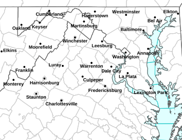
WIND ADVISORY REMAINS IN EFFECT UNTIL 6 AM EDT EARLY THIS MORNING URGENT – WEATHER MESSAGE
NATIONAL WEATHER SERVICE BALTIMORE MD/WASHINGTON DC
312 AM EDT MON MAR 31 2014
WASHINGTON-EXTREME WESTERN ALLEGANY-CENTRAL AND EASTERN ALLEGANY-
AUGUSTA-ROCKINGHAM-SHENANDOAH-FREDERICK VA-PAGE-WARREN-CLARKE-
NELSON-ALBEMARLE-GREENE-MADISON-RAPPAHANNOCK-LOUDOUN-CULPEPER-
PRINCE WILLIAM/MANASSAS/MANASSAS PARK-NORTHERN FAUQUIER-
SOUTHERN FAUQUIER-WESTERN HIGHLAND-EASTERN HIGHLAND-HAMPSHIRE-
MORGAN-BERKELEY-JEFFERSON-HARDY-WESTERN GRANT-EASTERN GRANT-
WESTERN MINERAL-EASTERN MINERAL-WESTERN PENDLETON-
EASTERN PENDLETON-
INCLUDING THE CITIES OF…HAGERSTOWN…FROSTBURG…CUMBERLAND…
STAUNTON…WAYNESBORO…HARRISONBURG…WINCHESTER…FRONT ROYAL…
CHARLOTTESVILLE…WASHINGTON…LEESBURG…CULPEPER…MANASSAS…
MANASSAS PARK…WARRENTON…HIGHTOWN…MONTEREY…MARTINSBURG…
CHARLES TOWN…MOOREFIELD…BAYARD…MOUNT STORM…PETERSBURG…
ELK GARDEN…KEYSER…FORT ASHBY…CIRCLEVILLE…FRANKLIN
312 AM EDT MON MAR 31 2014
…WIND ADVISORY REMAINS IN EFFECT UNTIL 6 AM EDT EARLY THIS
MORNING…
* TIMING…UNTIL 6 AM.
* WINDS…NORTHWEST 20 TO 30 MPH WITH GUSTS UP TO 50 MPH…MAINLY
FOR ELEVATIONS ABOVE 1000 FEET.
* IMPACTS…SCATTERED TREE AND POWER LINE DAMAGE. DIFFICULTY
DRIVING HIGH PROFILE VEHICLES.
PRECAUTIONARY/PREPAREDNESS ACTIONS…
A WIND ADVISORY MEANS THAT WIND GUSTS AROUND 50 MPH ARE EXPECTED.
SECURE OUTDOOR FURNITURE AND TAKE CARE DRIVING HIGH PROFILE
VEHICLES.
David Frey, promoter of the Lockn’ Festival which last September drew 25,000 people for the four-day event at Oak Ridge, said March 25 he was working with state and county officials on a traffic plan meant to prevent last year’s jams on local roads.
Speaking to a small audience of county residents and business owners at the Carriage House at Oak Ridge, Frey said last year the State Police, fearing a traffic emergency on U.S. 29 on the morning of the first day of the festival, tried to get every vehicle going to the event off the highway and on to local roads, causing traffic jams on secondary roads that lasted for hours.
With parking lots not scheduled to open until 2 p.m., Lockn’ workers and volunteers had to scramble to accommodate thousands of people in a field that had no toilet facilities, water or food. Meanwhile, vehicles routed by the State Police onto Wilson Road, Diggs Mountain Road and Arrington Road were unable to get into the festival grounds for many hours.
Doris Drumheller, who lives on Drumheller Orchard Road behind Nelson County High School, a few miles from Oak Ridge, said it took her six hours to get to the festival because she had been diverted onto Diggs Mountain Road. Other residents reported similar waits, and property owners along the affected roads reported people urinating on their properties because of the long waits and absence of porta-potties.
Frey apologized for last year’s difficulties but said things would be different this coming September. He said he was pressing the Virginia Department of Transportation and the State Police to allow left turns off of U.S 29 at Oak Ridge Road and into a field owned by Jay Goodwin near that intersection. Last year vehicles had to drive four miles south and make a U-turn near Tye River Road, where they were then diverted onto secondary roads.
Traffic lines up along Route 29 last year during the 2013 Lockn’ festival in Arrington.
Frey said Goodwin’s field would be equipped with porta-potties, water and food and the entry time into the festival would be much earlier in the morning. He said public schools, which were closed last September on Thursday and Friday of the festival to avoid the heavy traffic, would only need to be closed on Thursday.
Lester Saunders, whose family owns the Exxon Station, Colleen Drive-In and a seed and feed store on U.S. 29 just south of Rt. 56, said his businesses were hurt last year because crossovers on 29 were blocked by police. Vehicles were directed to make U-turns at Tye River or at Nelson County High School, several miles north and south of his businesses. “Those U-turns killed my business for three days,” he said, adding that he was paying ten employees who had little to do. “I can see the first day but it wasn’t necessary Friday or Saturday.”
Saunders also said he had purchased several thousand dollars worth of beer and other beverages expecting festival-goers to be customers, but hardly sold any and the beer distributor would not take it back.
Drumheller said her orchard business was affected negatively by Lockn’ because people were afraid of getting stuck in traffic on 29.
Other local business people along 29 reported sharp drops in business, rather than increases, because of media reports of terrible traffic. That was true Thursday morning when the event opened, but traffic was light to normal on Friday and Saturday.
Frey said they learned from last year’s experience that the vast majority of festival-goers preferred to remain on the Oak Ridge site and buy food and beer at the festival.
Frey said they would do more to communicate with local media this year, and mentioned using the Blue Ridge Life web site, Facebook and other social media to inform people accurately of traffic conditions. He said they would publish phone numbers people could call for information. He said people could also email: info@locknfestival.com
Ben Thompson, manager of food and beverage services for the festival, said Lockn’ was making an effort to involve more local businesses and non-profits with the event. He said they might lower the commission for local food and craft businesses, and they would provide refrigeration for food vendors. “We want to do a lot to make it possible for smaller mom and pop businesses to participate.”
Thompson said there was a “Get Involved” tab on locknfestival.com, that provides applications for craft and apparel businesses, food vendors and non-profits who want to participate.
Thompson said festival visitors who stayed at Wintergreen and elsewhere did eat at local restaurants and that Bonnie Wood, a marketing specialist for Lockn’, would be doing more to educate visitors about what is available in Nelson and the Central Virginia area.
Some area residents complained about music going on late into the night and the sound carrying for several miles. “There needs to be consideration for residents who live close by,” said Randy Helbert, who lives in Freshwater Cove.
Robert and Laura Canody, who said they live between Shipman and Lovingston, suggested the music end by 11 p.m. “We shouldn’t have to hear it at 1 a.m.,” Laura Canody said.
Frey and Festival Director Nigel James, said they were looking at re-orienting the stages so sound would travel to the south and east, rather than to the north and west. James said it might be possible to aim the speaker system lower to the ground.
Del Wood, who does marketing and promotions for the festival, said all in all, Lockn’ was a “very positive thing” for the county and the region from an economic standpoint. He said festival patrons spent 25% more than anticipated on the festival, much of it in the Central Virginia area.
Frey said they had spent $418,000 on gravel for roads, and had “cleaned out” local quarries in Nelson and Lynchburg. He said they had spent $83,000 for a traffic engineering firm to work with the Virginia Department of Transportation and State Police on traffic plans and another $60,000 on traffic cones and lighted signs. They purchased 78,000 gallons of fuel from Tiger Fuel for “a couple of hundred thousand dollars” to power temporary generators. A great deal of money was also spent on fencing.
“We expected to lose money but lost more than we thought. But we decided we could do it better. We want something for the long term that works for everybody,” Frey said. He said 63 percent of attendees were from out of state and that it was a “pretty well-off crowd.”
He asked for feedback from local businesses. “We want this to be like the New Orleans Jazz Festival. We hope a lot of people come, spend a lot of money, and leave.” The challenge, he said, was to help more people take advantage of the opportunities Lockn’ provides.
Arrington
Nelson County, VA
Organizers of the Lockn’ Festival held at Oak Ridge Estate met this past Tuesday night with businesses and residents about the upcoming early September event. The meeting was held to discuss concerns and help coordinate concerns about traffic and other issues that surround the four day event.
Central Virginia Blue Ridge
As predicted, accumulating snow began falling across the Central Virginia Blue Ridge Tuesday morning. By early afternoon anywhere from 3-5″ of snow had fallen with snow still coming down just after 2PM.
Winter Weather Statement
Statement as of 3:15 PM EDT on March 25, 2014
…Winter Storm Warning is cancelled…
The National Weather Service in Blacksburg has cancelled the
Winter Storm Warning.
Widespread accumulating snow has ended across the area.
WINTER STORM WARNING REMAINS IN EFFECT UNTIL 8 PM EDT THIS EVENING – (AMHERST & SOUTH) URGENT – WINTER WEATHER MESSAGE
NATIONAL WEATHER SERVICE BLACKSBURG VA
631 AM EDT TUE MAR 25 2014
..INCREASINGLY LIKELIHOOD OF ACCUMULATING SNOWFALL TODAY AND
TONIGHT…
.THE COMBINATION OF AN UPPER-LEVEL DISTURBANCE MOVING TOWARD THE
REGION FROM THE NORTHWEST AND A DEVELOPING COASTAL LOW OFF THE
NORTH CAROLINA…VIRGINIA COAST…WILL BRING ACCUMULATING
SNOWFALL TO THE REGION TODAY AND TONIGHT. THE HEAVIEST SNOW IS
EXPECTED TO OCCUR THROUGH THE SOUTHERN SHENANDOAH VALLEY THROUGH
THE AFTERNOON…AND THEN ACROSS EASTERN WEST VIRGINIA TONIGHT. IN
ADDITION…UNSEASONABLY COLD TEMPERATURES AND STRONG…GUSTY
NORTHWEST WINDS OVERNIGHT AND EARLY WEDNESDAY WILL RESULT IN WIND
CHILL READINGS IN THE SINGLE DIGITS TO AS LOW AS FIVE BELOW ZERO
IN GREENBRIER COUNTY WEST VIRGINIA.
VAZ017-022>024-033>035-252100-
/O.CON.KRNK.WS.W.0008.000000T0000Z-140326T0000Z/
FLOYD-ROANOKE-BOTETOURT-ROCKBRIDGE-FRANKLIN-BEDFORD-AMHERST-
INCLUDING THE CITIES OF…FLOYD…ROANOKE…SALEM…FINCASTLE…
LEXINGTON…BUENA VISTA…ROCKY MOUNT…BEDFORD…AMHERST
631 AM EDT TUE MAR 25 2014
…WINTER STORM WARNING REMAINS IN EFFECT UNTIL 8 PM EDT THIS
EVENING…
* LOCATIONS…SOUTHERN SHENANDOAH VALLEY AND ROANOKE VALLEY.
* HAZARD TYPES…SNOW.
* ACCUMULATIONS…SNOW ACCUMULATIONS OF 3 TO 4 INCHES…LOCALLY 5
INCHES. GREATEST TOTALS SHOULD BE ALONG EAST FACING SLOPES OF
THE BLUE RIDGE.
* TIMING…8 AM THIS MORNING UNITE 4 PM THIS AFTERNOON.
* IMPACTS…UNTREATED ROADS AND SURFACES WILL BECOME SNOW
COVERED… SLICK…AND HAZARDOUS.
* WINDS…NORTHWEST 5 TO 15 MPH WITH GUSTS UP TO 25 MPH.
* TEMPERATURES…LOWER TO MID 30S…FALLING INTO THE MID AND
UPPER 20S BY LATE AFTERNOON.
PRECAUTIONARY/PREPAREDNESS ACTIONS…
THIS WINTER WEATHER ADVISORY MEANS THAT PERIODS OF SNOW WILL
CAUSE TRAVEL DIFFICULTIES. BE PREPARED FOR SLIPPERY ROADS AND
LIMITED VISIBILITIES…AND USE CAUTION WHILE DRIVING.
A WINTER STORM WARNING FOR HEAVY SNOW MEANS SEVERE WINTER WEATHER
CONDITIONS ARE EXPECTED OR OCCURRING. SIGNIFICANT AMOUNTS OF SNOW
ARE FORECAST THAT WILL MAKE TRAVEL DANGEROUS. ONLY TRAVEL IN AN
EMERGENCY. IF YOU MUST TRAVEL…KEEP AN EXTRA FLASHLIGHT…FOOD…
AND WATER IN YOUR VEHICLE IN CASE OF AN EMERGENCY.
URGENT – WINTER WEATHER MESSAGE
NATIONAL WEATHER SERVICE BALTIMORE MD/WASHINGTON DC
623 AM EDT TUE MAR 25 2014
AUGUSTA-ROCKINGHAM-SHENANDOAH-PAGE-NELSON-ALBEMARLE-GREENE-
MADISON-EASTERN HIGHLAND-HARDY-EASTERN GRANT-EASTERN PENDLETON-
INCLUDING THE CITIES OF…STAUNTON…WAYNESBORO…HARRISONBURG…
CHARLOTTESVILLE…MONTEREY…MOOREFIELD…PETERSBURG…FRANKLIN
623 AM EDT TUE MAR 25 2014
…WINTER WEATHER ADVISORY REMAINS IN EFFECT UNTIL 3 PM EDT THIS
AFTERNOON…
* PRECIPITATION TYPE…SNOW.
* ACCUMULATIONS…2 TO 4 INCHES…UP TO 5 INCHES ON THE BLUE
RIDGE.
* TIMING…THE HEAVIEST SNOW IS EXPECTED LATE THIS MORNING
THROUGH EARLY AFTERNOON. SNOW WILL TAPER OFF DURING THE
AFTERNOON.
* TEMPERATURES…LOWER TO MID 20S THIS MORNING…WITH HIGHS
AROUND 30 ALONG THE RIDGE TOPS ABOVE 2000 FEET TO THE MID AND
UPPER 30S IN THE VALLEYS.
* WINDS…LIGHT AND VARIABLE.
* IMPACTS…ROADS WILL BECOME SNOW COVERED AND SLIPPERY FOR THE
THE MORNING COMMUTE. CONDITIONS WILL IMPROVE THIS AFTERNOON
WITH TEMPERATURES RISING ABOVE FREEZING IN THE VALLEYS.
HOWEVER… SNOW COVERED ROADS MAY CONTINUE THROUGH THIS
EVENING ALONG THE RIDGE TOPS ABOVE 2000 FEET.
PRECAUTIONARY/PREPAREDNESS ACTIONS…
A WINTER WEATHER ADVISORY MEANS THAT PERIODS OF SNOW WILL CAUSE
TRAVEL DIFFICULTIES. BE PREPARED FOR SLIPPERY ROADS AND LIMITED
VISIBILITIES…AND USE CAUTION WHILE DRIVING.
URGENT – WINTER WEATHER MESSAGE
NATIONAL WEATHER SERVICE BALTIMORE MD/WASHINGTON DC
830 PM EDT MON MAR 24 2014
AUGUSTA-ROCKINGHAM-SHENANDOAH-PAGE-NELSON-ALBEMARLE-GREENE-
MADISON-EASTERN HIGHLAND-HARDY-EASTERN GRANT-EASTERN PENDLETON-
INCLUDING THE CITIES OF…STAUNTON…WAYNESBORO…HARRISONBURG…
CHARLOTTESVILLE…MONTEREY…MOOREFIELD…PETERSBURG…FRANKLIN
830 PM EDT MON MAR 24 2014
…WINTER WEATHER ADVISORY IN EFFECT FROM 5 AM TO 3 PM EDT
TUESDAY…
THE NATIONAL WEATHER SERVICE IN BALTIMORE MD/WASHINGTON HAS
ISSUED A WINTER WEATHER ADVISORY FOR SNOW… WHICH IS IN EFFECT
FROM 5 AM TO 3 PM EDT TUESDAY.
* PRECIPITATION TYPE…SNOW.
* ACCUMULATIONS…2 TO 4 INCHES.
* TIMING…SNOW WILL BEGIN EARLY TUESDAY MORNING. THE HEAVIEST
SNOW IS EXPECTED TUESDAY MORNING. SNOW WILL TAPER OFF DURING THE
AFTERNOON.
* TEMPERATURES…LOW TEMPERATURES TONIGHT WILL BE IN THE LOWER TO
MIDDLE 20S. HIGH TEMPERATURES TUESDAY WILL RANGE FROM NEAR 30
ALONG THE RIDGE TOPS ABOVE 2000 FEET TO THE MID AND UPPER 30S IN
THE VALLEYS.
* WINDS…LIGHT AND VARIABLE.
* IMPACTS…ROADS WILL BECOME SNOW COVERED AND SLIPPERY FOR THE
THE MORNING COMMUTE TUESDAY AND DIFFICULT TRAVEL CONDITIONS ARE
EXPECTED DURING THIS TIME. CONDITIONS WILL IMPROVE TUESDAY
AFTERNOON WITH TEMPERATURES RISING ABOVE FREEZING IN THE
VALLEYS. HOWEVER…SNOW COVERED ROADS MAY CONTINUE THROUGH
TUESDAY AFTERNOON ALONG THE RIDGE TOPS ABOVE 2000 FEET.
PRECAUTIONARY/PREPAREDNESS ACTIONS…
A WINTER WEATHER ADVISORY MEANS THAT PERIODS OF SNOW WILL CAUSE
TRAVEL DIFFICULTIES. BE PREPARED FOR SLIPPERY ROADS AND LIMITED
VISIBILITIES…AND USE CAUTION WHILE DRIVING.
Wintergreen Resort
Nelson County, VA
Though skiing and snowboarding will go on for another week and one more weekend in April, the end is near for the 2013-2014 winter season at Wintergreen Resort. A favorite way to pay homage to the outgoing season is the annual Pond Skimming event at the resort. It’s part of the weekend Splash & Dash Celebration.
It’s official, we plan to ski and ride daily through 3/30 and re-open for one last day Saturday 4/5. Conditions are just too good to call it quits.
Spring Operating Schedule:
Saturday 3/22 & Sunday 3/23 – DAY SESSIONS ONLY 9-5
Tubing 12-4:30p
Monday 3/24 – Friday 3/28 – DAY SESSIONS ONLY 9-5
Tubing CLOSED
Saturday 3/29 & Sunday 3/30 – DAY SESSIONS ONLY 9-5
Tubing – Saturday 3/29 12-4:30p, Sunday TBD
Saturday 4/5 – OPEN – final day of the fantastic 13/14 ski and ride season. Second year in a row skiing and riding the first weekend in April…. SNOWPOWER and help for Mother Nature will make this one of the longest ski seasons ever!
In full dress, a pond skimmer skis across the water at Wintergreen Resort this past Saturday – March 22, 2014.To see lots more of Paul’s photos from Saturday’s Pond Skimming at Wintergreen, click on the thumbnail image above to head on over to his album.