The old store with lots of history brought back lots of the charm and some new things as well, like this past weekend’s bazaar.
People look over all sorts of crafts this past Sunday – December 7, 2014 at The Batesville Market’s Art Bazaar that featured work from Albemarle & Nelson County.
The next big event coming up at The Batesville Market is the Buzzard Hollow Boys CD release party on December 13th. Click on the market’s facebook posting above for more details.
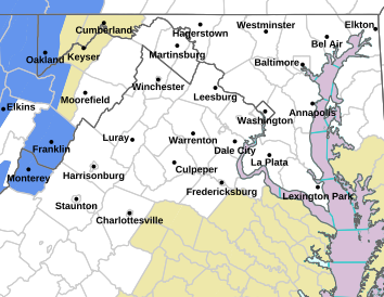
Via NWS: A WINTER WEATHER ADVISORY is in effect from 9PM Monday night until 8AM Tuesday morning for areas along and near the BRP in Central Virginia.
Winter Weather Statement
Statement as of 4:33 AM EST on December 09, 2014
…Winter Weather Advisory is cancelled…
The National Weather Service in Baltimore MD/Washington has
cancelled the Winter Weather Advisory.
Temperatures have risen above freezing.
WINTER WEATHER ADVISORY
URGENT – WINTER WEATHER MESSAGE
NATIONAL WEATHER SERVICE BALTIMORE MD/WASHINGTON DC
544 PM EST MON DEC 8 2014
EXTREME WESTERN ALLEGANY-CENTRAL AND EASTERN ALLEGANY-AUGUSTA-
ROCKINGHAM-SHENANDOAH-PAGE-WESTERN HIGHLAND-EASTERN HIGHLAND-
NORTHERN VA BLUE RIDGE-CENTRAL VA BLUE RIDGE-HAMPSHIRE-MORGAN-
HARDY-WESTERN GRANT-EASTERN GRANT-WESTERN MINERAL-EASTERN MINERAL-
WESTERN PENDLETON-EASTERN PENDLETON-
INCLUDING THE CITIES OF…FROSTBURG…CUMBERLAND…STAUNTON…
WAYNESBORO…HARRISONBURG…HIGHTOWN…MONTEREY…BIG MEADOWS…
WINTERGREEN…MOOREFIELD…BAYARD…MOUNT STORM…PETERSBURG…
ELK GARDEN…KEYSER…FORT ASHBY…CIRCLEVILLE…FRANKLIN
544 PM EST MON DEC 8 2014
…WINTER WEATHER ADVISORY REMAINS IN EFFECT FROM 9 PM THIS
EVENING TO 8 AM EST TUESDAY…
* PRECIPITATION TYPE…WINTRY MIX OF FREEZING RAIN…SLEET AND
SNOW.
* ACCUMULATIONS…A TRACE TO A COUPLE HUNDREDTHS OF AN INCH OF
ICE. SNOWFALL AROUND AN INCH.
* TIMING…LATE THIS EVENING INTO TUESDAY MORNING.
* TEMPERATURES…AROUND 30.
* WINDS…NORTH 5 TO 10 MPH.
* IMPACTS…ICING ON ROADWAYS COULD RESULT IN HAZARDOUS TRAVEL.
PRECAUTIONARY/PREPAREDNESS ACTIONS…
A WINTER WEATHER ADVISORY MEANS THAT PERIODS OF SNOW…SLEET…OR
FREEZING RAIN WILL CAUSE TRAVEL DIFFICULTIES. BE PREPARED FOR
SLIPPERY ROADS AND LIMITED VISIBILITIES…AND USE CAUTION WHILE
DRIVING.
URGENT – WINTER WEATHER MESSAGE
NATIONAL WEATHER SERVICE BLACKSBURG VA
539 PM EST MON DEC 8 2014
…LIGHT WINTRY MIX THIS EVENING AND OVERNIGHT…
.AN AREA OF LOW PRESSURE WILL MOVE NORTH ALONG THE EAST COAST
TONIGHT. PRECIPITATION ON THE WESTERN FLANK OF THE SYSTEM WILL
ENCOUNTER COLD AIR OVER THE ADVISORY AREA AS A MIX OF SNOW…
SLEET WITH A FEW POCKETS OF FREEZING RAIN.
MONTGOMERY-CARROLL-FLOYD-CRAIG-ALLEGHANY VA-BATH-ROANOKE-
BOTETOURT-ROCKBRIDGE-PATRICK-FRANKLIN-BEDFORD-AMHERST-
INCLUDING THE CITIES OF…BLACKSBURG…GALAX…FLOYD…
NEW CASTLE…CLIFTON FORGE…COVINGTON…HOT SPRINGS…ROANOKE…
SALEM…FINCASTLE…LEXINGTON…BUENA VISTA…STUART…
ROCKY MOUNT…BEDFORD…AMHERST
539 PM EST MON DEC 8 2014
…WINTER WEATHER ADVISORY NOW IN EFFECT UNTIL 8 AM EST TUESDAY…
* LOCATIONS…VIRGINIA COUNTIES BORDERING THE BLUE RIDGE PARKWAY
FROM THE NORTH CAROLINA BORDER NORTH TO AHMERST COUNTY…AND
WEST INTO THE NEW RIVER VALLEY…AND ALSO PARTS OF THE SOUTHERN
ALLEGHANY HIGHLANDS.
* HAZARD TYPES…MAINLY SNOW AND SLEET…A FEW POCKETS OF
FREEZING RAIN.
* ACCUMULATIONS…SNOW AND SLEET ACCUMULATION OF UP TO 1 INCH…
HIGHER ELEVATIONS BETWEEN AMHERST AND BATH COUNTIES MAY HAVE 1
TO 2 INCHES. ISOLATED TRACE AMOUNTS OF ICE.
* TIMING…600 PM THROUGH 800 AM.
* IMPACTS…LIGHT COATING OF A WINTRY MIX ON ROADS…PARKING
LOTS…AND SIDEWALKS. ELEVATED SURFACE SHOULD BECOME SLICK
FIRST.
* WINDS…NORTH 5 TO 10 MPH.
* TEMPERATURES…IN THE LOWER 30S.
PRECAUTIONARY/PREPAREDNESS ACTIONS…
A WINTER WEATHER ADVISORY MEANS THAT PERIODS OF SNOW…SLEET…OR
FREEZING RAIN WILL CAUSE TRAVEL DIFFICULTIES. BE PREPARED FOR
SLIPPERY ROADS AND LIMITED VISIBILITIES…AND USE CAUTION WHILE
DRIVING.
Lovingston
Nelson County, Virginia
Floats, fire trucks, a miniature car driven by a fake dog, free hot chocolate and delicious soup, and Santa Claus brought the cheer this Sunday afternoon in Lovingston. Everyone got in the spirit on a beautiful sunny, cool day at the annual Nelson County Christmas Parade. Our Shay Munroe was there to capture all of the sights!
Check out her complete album below on our Facebook page. It contains dozens and dozens more!
Via NWS: A WINTER WEATHER ADVISORY is in effect until 10AM Friday morning for areas along and immediately either side of the Blue Ridge Parkway from roughly Montebello north along the Skyline Drive to near Luray. This is for the higher elevations.
WINTER WEATHER ADVISORY IN EFFECT UNTIL 10 AM EST FRIDAY URGENT – WINTER WEATHER MESSAGE
NATIONAL WEATHER SERVICE BALTIMORE MD/WASHINGTON DC
537 PM EST THU DEC 4 2014
NORTHERN VA BLUE RIDGE-CENTRAL VA BLUE RIDGE-
INCLUDING THE CITIES OF…BIG MEADOWS…WINTERGREEN
537 PM EST THU DEC 4 2014
…WINTER WEATHER ADVISORY IN EFFECT UNTIL 10 AM EST FRIDAY…
THE NATIONAL WEATHER SERVICE IN BALTIMORE MD/WASHINGTON HAS
ISSUED A WINTER WEATHER ADVISORY FOR SNOW…SLEET AND FREEZING
RAIN…WHICH IS IN EFFECT UNTIL 10 AM EST FRIDAY.
* PRECIPITATION TYPE…SNOW…SLEET AND FREEZING RAIN.
* ACCUMULATIONS…A COATING OF SNOW AND SLEET. A TRACE TO AROUND
ONE TENTH OF AN INCH OF ICE FROM FREEZING RAIN.
* TIMING…SNOW AND SLEET WILL CHANGE TO FREEZING RAIN THIS
EVENING. FREEZING RAIN IS EXPECTED OVERNIGHT BEFORE TURNING TO
ALL RAIN LATER FRIDAY MORNING.
* TEMPERATURES…LOWER 30S.
* WINDS…SOUTHEAST 5 TO 10 MPH.
* IMPACTS…ROADS MAY BE SLIPPERY AT TIMES…MAKING TRAVEL
DIFFICULT.
PRECAUTIONARY/PREPAREDNESS ACTIONS…
A WINTER WEATHER ADVISORY MEANS THAT PERIODS OF SNOW…SLEET…OR
FREEZING RAIN WILL CAUSE TRAVEL DIFFICULTIES. BE PREPARED FOR
SLIPPERY ROADS AND LIMITED VISIBILITIES…AND USE CAUTION WHILE
DRIVING.
Conductor Judy Diloia, accompanied by Tom Krop on the accordion, lead the chorus in singing Christmas carols as the ceremony began.Spectators sing along with the chorus this past Wednesday night – December 3, 2014 during the annual tree lighting held in Stoney Creek.Steve McInich along with his daughter Chloe from Charlottesville, listen to the chorus sing Christmas carols.Lighting of the Christmas Tree by Cindy Cobb.Ron Turnbull recites ‘Twas The Night Before Christmas while children look on during the annual tree lighting held this past Wednesday evening – December 3, 2014 at Stoney Creek in Nellysford, VA.The man of the hour! Santa Claus arrives atop a fire engine from Wintergreen Fire & Rescue!
After the ceremony Wednesday evening Santa headed back to the North Pole to coordinate with his elves for Christmas Eve deliveries in just a few weeks!
Via NWS: A WINTER WEATHER ADVISORY is in effect until 1AM Wednesday for most of the Blue Ridge area along and near the BRP.
Winter Weather Statement
Statement as of 6:46 PM EST on December 02, 2014
…Winter Weather Advisory is cancelled…
The National Weather Service in Baltimore MD/Washington has
canceled the Winter Weather Advisory.
WINTER WEATHER ADVISORY REMAINS IN EFFECT UNTIL 1 AM EST WEDNESDAY URGENT – WINTER WEATHER MESSAGE
NATIONAL WEATHER SERVICE BALTIMORE MD/WASHINGTON DC
1237 PM EST TUE DEC 2 2014
NELSON-ALBEMARLE-GREENE-MADISON-RAPPAHANNOCK-
INCLUDING THE CITIES OF…CHARLOTTESVILLE…WASHINGTON
1237 PM EST TUE DEC 2 2014
…WINTER WEATHER ADVISORY REMAINS IN EFFECT UNTIL 1 AM EST
WEDNESDAY…
* PRECIPITATION TYPE…FREEZING RAIN.
* ACCUMULATIONS…UP TO A TENTH INCH OF ICE ACCUMULATION.
* TIMING…FREEZING RAIN WILL TAPER OFF LATE THIS AFTERNOON OR
EARLY THIS EVENING. FREEZING DRIZZLE IS POSSIBLE OVERNIGHT.
* TEMPERATURES…IN THE UPPER 20S TO LOWER 30S.
* WINDS…NORTHEAST 10 MPH WITH GUSTS UP TO 20 MPH.
* IMPACTS…RIDGE LINE ROADS SUCH AS SKYLINE DRIVE MAY BECOME
ICY… MAKING TRAVEL DIFFICULT.
PRECAUTIONARY/PREPAREDNESS ACTIONS…
A WINTER WEATHER ADVISORY MEANS THAT PERIODS OF SLEET OR FREEZING
RAIN WILL CAUSE TRAVEL DIFFICULTIES. BE PREPARED FOR SLIPPERY
ROADS AND LIMITED VISIBILITIES…AND USE CAUTION WHILE DRIVING.
Near Nellysford
Nelson County, Virginia
Weather over this past weekend was pretty phenomenal for a Thanksgiving weekend! On Sunday the temps made it to 66° in the valley and even in the mountains temps made it to the lower 50’s with plenty of sunshine. Tommy says we get one more nice day on Monday with minimal chances for rain late in the day and temps in the mid and upper 60’s once again, but more winter like weather returns overnight into Tuesday. This time icing is more of a concern versus snow we saw last week.
Tommy talks more about the approaching winter type weather we will see overnight Monday into Tuesday in his daily weathercast above. Press play to listen now, and enjoy your mild Monday!
Wintergreen Resort
Nelson County, Virginia We’ve been telling you for several days that it looked like Wintergreen Resort would be open by the day after Thanksgiving. It happened and it was the first time ever they were able to get open by Thanksgiving weekend. Thanks to mother nature’s help with cold temps and an additional 6-8 inches of snow on Thanksgiving Eve, they were able to open on Friday.
Central Virginia Blue Ridge As Tommy’s been discussing over the past several days, a Thanksgiving Eve winter storm began hitting the Blue Ridge area around daylight Wednesday. Down below the temperatures have primarily been too warm for snow coverage in the immediate area. But up top at Wintergreen and along the Blue Ridge Parkway, plenty of snow has been falling all morning.
Photo courtesy of Shenandoah NPS: “The entire length of Skyline Drive is currently closed to due to snow and ice. For the most current Drive status, call: 540-999-3500, Option 1, then Option 1 again. For information regarding Skyland Resort, call: 540-999-2212 Photo: Mile 44, Early Morning, 11-26-14″
If you travel away from Nelson where we are based, interstates have become problematic in many areas.
Photo courtesy of Marion Kanour: I-81 Southbound, south of I-64 had started to cover in snow early Wednesday morning.Photo courtesy of Betsy Smith: The 81/64 split at Staunton was a mess early Wednesday morning.Photo Courtesy of Craig Nargi: Route 608 between Hermitage and New Hope in Augusta County.
Near Wingina
Nelson County, VA (Updated 11.27.14 5:00 PM)
Nelson County Sheriff David Brooks confirmed to BRL that the search for the suspect being sought in the pursuit two days ago is over and 26 year old Lance Sites is dead. “Family made the discovery. We are investigating the circumstances as to exactly what happened and will be releasing more information when we have more details,” Sheriff Brooks said he was notified of the death early Thursday afternoon.
(Updated 11.26.14 10:30 AM)
Nelson County Sheriff David Brooks says a man that fled on foot after a brief police pursut by one of his deputies is still on the run. “We now have charges for Lance Sites, a 26 year old male from the North Garden area. Sites fled the the scene and we have charges obtained for felony eluding, driving on a suspended driver’s license and more charges pending. No one was injured.,” Sheriff Brooks tells BRL on Wednesday morning.
(Original Post from 11.25.14 at 10:09 PM) Nelson County Sheriff David Brooks confirms to BRL that his department and the Virginia State Police are involved in a search for a suspect that fled on foot after a police pursuit by one of his deputies in Eastern Nelson County. Originally three people were in the truck but only the one fled. Two other female passengers aren’t under any suspicion currently.
“He jumped from a pickup after my deputy had been in pursuit for a few minutes. He jumped out in the vicinity of Red Apple Orchard Lane and Route 56,” Sheriff Brooks told us just before 10 PM Tuesday night.
Deputies on the scene requested a VSP helicopter to aid in the search. Sheriff Brooks said the driver was being stopped for a traffic violation when the registration didn’t match the vehicle. That’s when the chase began. Tracking dogs are also aiding in the search.
Anyone that sees suspicious activity in the area is encouraged to call the sheriff’s department at 434.263.7050