
Home Blog Page 171

Flash Flood Watches For All Of Central VA Expired Or Canceled

0

Via NWS: Some of the area remains under a flash flood watch until Saturday evening.
 

CANCELED – CANCELED – CANCELED 


FLOOD WATCH

NATIONAL WEATHER SERVICE BLACKSBURG VA

348 AM EDT SAT OCT 3 2015
…PERIODS OF MODERATE TO HEAVY RAIN STILL EXPECTED THIS TODAY…
.LOW PRESSURE WILL TRACK SLOWLY ALONG A STATIONARY COASTAL FRONT

AND COMBINE WITH DEEP MOISTURE TO PRODUCE PERIODS OF MODERATE TO

HEAVY RAIN ACROSS THE REGION THROUGH TONIGHT. FORECAST RAINFALL

AMOUNTS HAVE BEEN SLIGHTLY LOWERED RESULTING IN A REDUCED RIVER

FLOOD THREAT.
VAZ010>020-022>024-032>035-043-031600-

/O.CON.KRNK.FF.A.0008.000000T0000Z-151004T0000Z/

/00000.0.ER.000000T0000Z.000000T0000Z.000000T0000Z.OO/

BLAND-GILES-WYTHE-PULASKI-MONTGOMERY-GRAYSON-CARROLL-FLOYD-CRAIG-

ALLEGHANY VA-BATH-ROANOKE-BOTETOURT-ROCKBRIDGE-PATRICK-FRANKLIN-

BEDFORD-AMHERST-HENRY-

INCLUDING THE CITIES OF…BLAND…PEARISBURG…WYTHEVILLE…

RADFORD…PULASKI…BLACKSBURG…INDEPENDENCE…WHITETOP…

TROUTDALE…VOLNEY…GALAX…FLOYD…NEW CASTLE…CLIFTON FORGE…

COVINGTON…HOT SPRINGS…ROANOKE…SALEM…FINCASTLE…

LEXINGTON…BUENA VISTA…STUART…ROCKY MOUNT…BEDFORD…

AMHERST…MARTINSVILLE

348 AM EDT SAT OCT 3 2015
…FLASH FLOOD WATCH REMAINS IN EFFECT THROUGH THIS EVENING…
THE FLASH FLOOD WATCH CONTINUES FOR
* PORTIONS OF CENTRAL VIRGINIA…SOUTH CENTRAL VIRGINIA…

  SOUTHWEST VIRGINIA AND WEST CENTRAL VIRGINIA…INCLUDING THE

  FOLLOWING IN CENTRAL …VIRGINIA…AMHERST. IN SOUTH CENTRAL

  VIRGINIA…BEDFORD AND HENRY. IN SOUTHWEST VIRGINIA…BLAND…

  CARROLL…CRAIG…FLOYD…GILES…GRAYSON…MONTGOMERY…

  PATRICK…PULASKI AND WYTHE. IN WEST CENTRAL VIRGINIA…

  ALLEGHANY VA…BATH…BOTETOURT…FRANKLIN…ROANOKE AND

  ROCKBRIDGE.
* THROUGH THIS EVENING
* UP TO AN INCH OF RAIN IS EXPECTED…WITH LOCALLY HIGHER AMOUNTS

  ALONG THE EAST SLOPES OF THE BLUE RIDGE. THIS RAIN WILL BE

  FALLING ON SOIL THAT IS COMPLETELY SATURATED. THIS WILL LEAD TO

  MUCH OF THE RAIN RUNNING OFF INTO SMALL STREAMS AND CREEKS.
* IN ADDITION TO THE THREAT FOR FLASH FLOODING…SOME AREA

  RIVERS COULD FLOOD. CURRENT RIVER FORECASTS BASED ON THE

  ANTICIPATED WIDESPREAD RAINFALL SHOW MINOR FLOODING ON THE

  UPPER ROANOKE FROM ABOVE ROANOKE DOWNSTREAM TO SMITH MOUNTAIN

  LAKE. LOWERED RAINFALL FORECASTS NOW SUGGEST THAT THE UPPER

  JAMES AND PARTS OF NEW RIVER MAY NOT REACH FLOOD STAGE BUT

  COULD STILL RISE VERY CLOSE TO FLOOD STAGE.
TREES COULD ALSO BE TOPPLED GIVEN THE WET SOIL CONDITIONS AND

GUSTY NORTHEAST BREEZES EXPECTED.
PRECAUTIONARY/PREPAREDNESS ACTIONS…
A FLASH FLOOD WATCH MEANS THAT CONDITIONS MAY DEVELOP THAT LEAD

TO FLASH FLOODING. FLASH FLOODING IS A VERY DANGEROUS SITUATION.

YOU SHOULD MONITOR LATER FORECASTS AND BE PREPARED TO TAKE ACTION

SHOULD FLASH FLOOD WARNINGS BE ISSUED.
AN INCREASED RISK OF LANDSLIDES IS EXPECTED WITH THIS STORM. IF

YOU LIVE IN AN AREA PRONE TO LANDSLIDES…HEAD TOWARD HIGHER

GROUND AWAY FROM STREAMS…RIVERS…AND STEEP SLOPES.
&&
$$

FLOOD WATCH

NATIONAL WEATHER SERVICE BLACKSBURG VA

348 AM EDT SAT OCT 3 2015
…PERIODS OF MODERATE TO HEAVY RAIN STILL EXPECTED THIS TODAY…
.LOW PRESSURE WILL TRACK SLOWLY ALONG A STATIONARY COASTAL FRONT

AND COMBINE WITH DEEP MOISTURE TO PRODUCE PERIODS OF MODERATE TO

HEAVY RAIN ACROSS THE REGION THROUGH TONIGHT. FORECAST RAINFALL

AMOUNTS HAVE BEEN SLIGHTLY LOWERED RESULTING IN A REDUCED RIVER

FLOOD THREAT.
NCZ005-006-VAZ044>047-058-059-031600-

/O.CON.KRNK.FF.A.0008.000000T0000Z-151004T0000Z/

/00000.0.ER.000000T0000Z.000000T0000Z.000000T0000Z.OO/

ROCKINGHAM-CASWELL-PITTSYLVANIA-CAMPBELL-APPOMATTOX-BUCKINGHAM-

HALIFAX-CHARLOTTE-

INCLUDING THE CITIES OF…EDEN…YANCEYVILLE…DANVILLE…

LYNCHBURG…APPOMATTOX…SOUTH BOSTON…KEYSVILLE

348 AM EDT SAT OCT 3 2015
…FLASH FLOOD WATCH REMAINS IN EFFECT THROUGH THIS EVENING…
THE FLASH FLOOD WATCH CONTINUES FOR
* PORTIONS OF NORTH CENTRAL NORTH CAROLINA AND VIRGINIA…

  INCLUDING THE FOLLOWING IN NORTH …CENTRAL NORTH CAROLINA…

  CASWELL AND ROCKINGHAM. IN VIRGINIA…APPOMATTOX…

  BUCKINGHAM…CAMPBELL…CHARLOTTE…HALIFAX AND PITTSYLVANIA.
* THROUGH THIS EVENING
* AN ADDITIONAL HALF OF AN INCH OF RAIN IS EXPECTED…WITH

  LOCALLY HIGHER AMOUNTS. THIS RAIN WILL BE FALLING ON SOIL THAT

  WAS COMPLETELY SATURATED. THIS WILL LEAD TO MUCH OF THE RAIN

  RUNNING OFF INTO SMALL STREAMS AND CREEKS AND CAUSING RAPID

  RISES AND FLOODING.
* IN ADDITION TO THE THREAT FOR FLASH FLOODING…SOME AREA RIVERS

  ARE ALSO LIKELY TO FLOOD. CURRENT RIVER FORECASTS BASED ON THE

  ANTICIPATED RAINFALL SHOW PARTS OF THE LOWER ROANOKE AND DAN

  RIVERS EITHER RISING BACK OVER FLOOD STAGE THIS MORNING OR

  RISING TO A HIGHER CATEGORY IN THE LOWER DAN.
TREES COULD ALSO BE TOPPLED GIVEN THE WET SOIL CONDITIONS AND

GUSTY NORTHEAST WIND EXPECTED.
PRECAUTIONARY/PREPAREDNESS ACTIONS…
A FLASH FLOOD WATCH MEANS THAT CONDITIONS MAY DEVELOP THAT LEAD

TO FLASH FLOODING. FLASH FLOODING IS A VERY DANGEROUS SITUATION.

YOU SHOULD MONITOR LATER FORECASTS AND BE PREPARED TO TAKE ACTION

SHOULD FLASH FLOOD WARNINGS BE ISSUED.

Hurricane Joaquin Heads Out To Sea : Updated 5:10 PM – 10.2.15

0
The current position and projected path of Hurricane Joaquin Joaquin may factor into our weekend forecast that already includes very heavy rains across the Central Virginia Blue Ridge area : Click to see an enlarged view. 

Central Virginia Blue Ridge
Hurricane Joaquin is moving out to sea. By Saturday it will be on a NNE course away from the US and very little threat. A Flash Flood Watch continues for the VA Central Blue Ridge Area from Friday morning until Saturday.

Hurricane Joaquin is now weakening a bit, down to a Category 3 hurricane, as is now lifting off to the north before…

Posted by CBS 19 Weather – The Weather Authority on Friday, October 2, 2015


Above, Tommy says we’ll still some rain (occasionally heavy locally) over the weekend, but amounts won’t be a much as previously anticipated earlier in the week. Sun returns by early next week.

Major Flooding Hits Central Virginia Blue Ridge Area

0
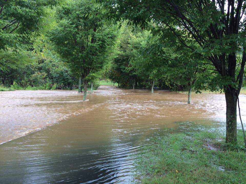
Photo Courtesy of Amy Winters : Flood waters cover the driveway and nearby Glenthorne Loop near Nellysford in Nelson County. Over 3" of rain fell near there Tuesday afternoon and more than 6" of rain fell just above at Wintergreen Resort at 3500 feet.
Photo Courtesy of Amy Winters : Flood waters cover the driveway and nearby Glenthorne Loop near Nellysford in Nelson County. Over 3″ of rain fell near there Tuesday afternoon and more than 6″ of rain fell just above at Wintergreen Resort at 3500 feet.

Nelson County, Virginia and Nearby Areas
As Tommy mentioned might happen in his forecast, major pounding rains fell across the Central Virginia Blue Ridge area on Tuesday afternoon creating all sorts of problems. Many roads have been closed and some accidents have occurred.

Unfortuantely more rain is on the way this week, some heavy. Tommy covers that more in his weather, here later this evening.

At our BRL-Nature Foundation Station at Wintergreen gauge we showed just over 6" of rain by late Tuesday afternoon. The majority of the rain fell between noon and 5PM.
At our BRL-Nature Foundation Station at Wintergreen gauge we showed just over 6″ of rain by late Tuesday afternoon. The majority of the rain fell between noon and 5PM. Click to enlarge.
Down below our BRL-Trager Brothers station showed about half that amount. Just over 3".
Down below our BRL-Trager Brothers station showed about half that amount. Just over 3″.

Well….that was an adventure. Thankful that the roads were clear coming down from Wintergreen and down 151, but there…

Posted by Victoria Mininger on Tuesday, September 29, 2015

The tye is out of its banks Nelson Mag

Posted by Suzanne Wood on Tuesday, September 29, 2015

A little sample of what we've been getting over past several hours.

Posted by Tommy Stafford on Tuesday, September 29, 2015

Flood Watch In Effect From Tuesday Afternoon Until Wednesday Morning – CANCELED

0
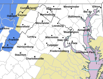
Via NWS : A Flood Watch is in effect for the areas shaded in green.

FLOOD WATCHNATIONAL WEATHER SERVICE BALTIMORE MD/WASHINGTON DC

827 AM EDT TUE SEP 29 2015

AUGUSTA-ROCKINGHAM-SHENANDOAH-PAGE-WARREN-NELSON-ALBEMARLE-GREENE-

MADISON-RAPPAHANNOCK-NORTHERN VA BLUE RIDGE-CENTRAL VA BLUE RIDGE-

INCLUDING THE CITIES OF…STAUNTON…WAYNESBORO…STUARTS DRAFT…

HARRISONBURG…STRASBURG…WOODSTOCK…MOUNT JACKSON…

NEW MARKET…LURAY…SHENANDOAH…STANLEY…FRONT ROYAL…

LOVINGSTON…CHARLOTTESVILLE…STANARDSVILLE…MADISON…

WASHINGTON…BIG MEADOWS…WINTERGREEN

827 AM EDT TUE SEP 29 2015
…FLASH FLOOD WATCH IN EFFECT FROM 4 PM EDT THIS AFTERNOON

THROUGH WEDNESDAY MORNING…
THE NATIONAL WEATHER SERVICE IN STERLING VIRGINIA HAS EXPANDED

THE
* FLASH FLOOD WATCH TO INCLUDE PORTIONS OF CENTRAL VIRGINIA…

  NORTHERN VIRGINIA…NORTHWEST VIRGINIA AND WESTERN VIRGINIA…

  INCLUDING THE FOLLOWING IN CENTRAL …VIRGINIA…ALBEMARLE…

  GREENE AND NELSON. IN NORTHERN VIRGINIA…CENTRAL VA BLUE

  RIDGE AND NORTHERN VA BLUE RIDGE. IN NORTHWEST VIRGINIA…

  MADISON…PAGE…RAPPAHANNOCK…ROCKINGHAM…SHENANDOAH AND

  WARREN. IN WESTERN VIRGINIA…AUGUSTA.
* FROM 4 PM EDT THIS AFTERNOON THROUGH WEDNESDAY MORNING.
* SHOWERS AND THUNDERSTORMS WILL BECOME MORE WIDESPREAD ACROSS THE

  CENTRAL APPALACHIANS AHEAD OF A COLD FRONT THIS AFTERNOON. THIS

  IS TROPICAL MOISTURE SO RAINFALL RATES WILL BE INTENSE. ALSO

  THERE WILL BE POTENTIAL FOR TRAINING OR REPEATED THUNDERSTORM

  ACTIVITY OVER THE SAME AREAS WHICH FURTHER INCREASES THE RISK

  OF FLOODING.
* TWO TO FOUR INCHES OF RAIN ARE LIKELY FROM THE BLUE RIDGE TO THE

  ALLEGHENY MOUNTAINS…MUCH OF WHICH SHOULD FALL IN A SHORT

  PERIOD OF TIME. THESE AMOUNTS COULD RESULT IN FLASH FLOODING OF

  SMALL STREAMS AND CREEKS.
PRECAUTIONARY/PREPAREDNESS ACTIONS…
A FLASH FLOOD WATCH MEANS THAT CONDITIONS MAY DEVELOP THAT LEAD

TO FLASH FLOODING. FLASH FLOODING IS A VERY DANGEROUS SITUATION.
YOU SHOULD MONITOR LATER FORECASTS AND BE PREPARED TO TAKE ACTION

SHOULD FLASH FLOOD WARNINGS BE ISSUED.
Friends Of Nelson Shows Water Usage For Hydrostatic Testing Of The ACP

1

Screen Shot 2015-09-28 at 10.06.56 AM

Nelson County, Virginia

As the march toward the Atlantic Coast Pipeline construction nears, Friends of Nelson and other organizations fighting the pipeline continue revealing information on the effects of the pipeline.

“Dominion plans to take 3.6 million gallons of water from the South Fork of the Rockfish to hydrostatically test the ACP … and more from undisclosed locations for dust control (38 MG throughout the project).”

This information is from their Facebook post linked below. Click there for more info and a closer look.

Dominion plans to take 3.6 million gallons of water from the South Fork of the Rockfish to hydrostatically test the ACP … and more from undisclosed locations for dust control (38 MG throughout the project).

Posted by Friends of Nelson on Sunday, September 27, 2015

5th Annual Misty Mountain Music Festival Continues Over Weekend

0

Screen Shot 2015-09-26 at 9.23.35 AM

Greenwood
Albemarle County, Virginia

In spite of the light rain that’s been falling over the past day, it’s been a great time at the 5th Annual Misty Mountain Music Festival being held in Greenwood, Virginia at the Misty Mountain Campground. “We had a blast last night even with the rain. Great music, Blue Mountain Beer and South Street beer of course, kids activities and more great music. Tents were set up and fire pits were raging. We’re kicking it off again today at 1pm,” Mandi Smack tells us. She’s the co-owner of Blue Mountain Brewery in Afton and South Street Brewery in Charlottesville, and an anchor sponsor of the festival.

Organizers of the annual festival say, “The festival does not require ticket purchases, instead monetary donations to the Blue Ridge Area Food Bank will be accepted daily at the festival gates. 2014’s festival raised over $7,000- for BRAFB we want to double that this year with a goal of $14,000.”

The rain definitely hasn’t stopped the fun! “We had a pickin party until around 4am too,” says John Howard the event coordinator and local musician.

Here’s the lineup for the remainder of the 2015 festival:

Saturday September 26th

1pm Robin Wynn
2pm Paulo Franco & the Rateros
3pm Shamokin Mountain
4pm Kristen Rae Bowden
5pm Hound Dog Hill
6pm Firecracker Jam
7pm Gold Top County Ramblers
8pm Gallatin Canyon
9pm Scintillation Fire Troupe
9:20 Bassically Blue
10:15 Sun Dried Opossum

Sunday September 27th

1pm Her Checkered Past
2pm Jason Burke
3pm Dickie Wood of the Atkinsons
4pm Jason Ring
5pm Curtis Prince & the Associates
6pm Hogwaller Ramblers

To learn more about this year’s festival, go here!

See everyone there!

EXPECT DELAYS ON ROUTE 501 NEAR ROCKBRIDGE/AMERST LINE

0

VDOT_Logo

LYNCHBURG – An incident involving an overturned tractor-trailer on Route 501 in the vicinity of the Rockbridge/Amherst line may create delays for motorists in the area.

Route 501 is currently blocked and traffic is being detoured via Routes 635 and 60. The road is expected to be closed for several hours.

For updates on this delay, please call 511 or visit www.511Virginia.org.

Here’s Your Chance To Win Free Tickets To The Festy – Congrats to Winners! 

2

Screen Shot 2015-09-19 at 8.56.47 AM

Roseland
Nelson County, Virginia

Updated 9.23.15 3PM

Congrats to Oona Price of Lynchburg and Jaime Miller of Nelson County. They each won a free pair of tickets to The Festy that’s coming up next month. 

We see you all there starting October 9th! 

Original Post Below:
We’ve been talking about this all week over Tommy’s Weather. Here’s our chance to win a pair of free tickets to The Festy in October. Just listen to Tommy’s Weather (upper right on this page or down below) and learn how to get you chance at those tickets now!

Good luck and see you at The Festy!

So Long Summer – Fall Officially Begins Today!

0

fall_leaves

Central Virginia Blue Ridge
We can say so long to those long hot summer days and welcome in the cooler, crisper fall days now! (At least on the calendar) Fall officially began this morning at 4:21AM eastern time. It runs until December 21st when Winter officially begins. That’s also the shortest day of the year, daylight slowly begins increasing after that.

Until then begin enjoying some of the beautiful colors that will start to appear in the coming weeks. The Central Virginia Blue Ridge is one of the prettiest places around in the fall!

Enjoy!

Buckingham : Planned Power Outage For Saturday Night – September 19, 2015

0

Screen Shot 2015-09-19 at 8.51.26 AM

Buckingham County, Virginia
And Nearby Areas

CVEC & AEP will have a planned power outage for customers served by their North Buckingham Centenary Substation. To read more times and areas affected, click on their Facebook post below.

- Advertisement -