Photo courtesy pf RVCC: Volunteers began the construction this week of what will eventually become the Blue Mountain Pavilion.
Afton / Greenfield
Nelson County, Virginia
After months of preparation the Blue Mountain Pavilion Project is underway at Rockfish Valley Community Center. It’s a joint effort with the Building Goodness Foundation. Once completed the pavilion will be a place to “provide a protected outdoor performance venue for events large and small,” says Mandi Smack, Blue Mountain Brewery’s co-founder.
Project coordinators are also looking for volunteers to help with the project.
“Work days are scheduled for April 23, 24, and April 30, and we could use some help. Whether you swing a mean hammer or sling a mean burger, we need you! Please let us know if you can help out at any time on any of these days. 434-361-0100 or email rockfishcc@gmail.com.”
Below, more pics from RVCC’s Facebook album as the project begins. Very exciting!
Nelson County’s second established craft brewery founded back in 2008 will be acquired by Anheuser-Busch.
Shortly after noon Tuesday, we caught up with Steve Crandall the founder of Devils Backbone and had a 10 minute or so interview with him about the acquisition.
The interview below in its entirety.
This is the announcement was on the Devils Backbone Facebook page:
From Steve, our Founder:
Devils Backbone was built with a unique, adventurous spirit, and our job is to preserve that culture. That being said, our vision has now outgrown our means. We still know where we want to go, but we realized we needed a partner to get there. For the past year we’ve been exploring options for a long-term solution that would enable us to continue expanding our business of brewing consistent, high-quality craft beer. As I evaluated our options, ABI’s The High End rose to the forefront as a support team that believed in our dreams. We had many discussions and the more we spoke with ABI, the clearer it became that The High End shares our passion. All of our senior management are on board with this new direction and in it for the long haul. ABI will support our brand as we build out our dream of what Devils Backbone can become.
You are going to see many new exciting additions to Basecamp Brewpub & Meadows, located in beautiful Nelson County including permanent camping and RV locations, some added infrastructure, all which will enhance our customer experience. At the Outpost Brewery & Tap Room in Lexington, we are planning a 50,000 square foot expansion to include our new state of the art shipping and receiving facility along with additional packaging automation. All these improvements have been in the planning for many years and they will continue to have our own authentic DNA on them.
We will continue to encourage craft beer large and small to play fair, enjoy all things beer, support our employees and communities, love our fans and celebrate life. To all our family, friends and beer fans, we could not have made this journey without you and we look forward to sharing our future with you.
Cheers,
Steve Crandall
~ Founder ~:
All About Beer reports the acquisition in a post this morning.
Central Virginia Blue Ridge
One half of of this past weekend was wicked when it came to weather. Wind gusts of 30, 40, even 50 MPH in the mountains along with temps in the 30s and low 40s on Saturday made it pretty miserable on Saturday. That didn’t stop folks from getting out and enjoying some spring traditions that take place starting in April. Check out our coverage of the events in our Facebook albums below.
With winds gusting as high as 40 MPH & temps hovering in the 30s and 40s, people still braved it all for the opening day…
In spite of crazy winds and crazy temps, it was a great turnout for the BE BOLD 4 Miler held at Bold Rock Hard Cider – Our Marcie Gates braves the winds and the cold to grab a some shots!
Photo courtesy of Kim Chappell : On Sunday the inaugural ride of the Bold Rock Mountain Bike Club kicked off. Bikers gathered up at Bold Rock before heading out!
Photo Courtesy of Neil Richardson : After the ride everyone piled inside Bold Rock and enjoyed some cider and great conversation. Next weekend’s event is Conquer the Hill!
As the weather gets warmer and warmer, more things start happening in the Blue Ridge area.
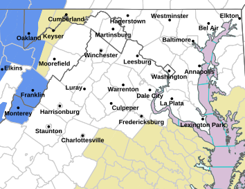
Via NWS : Various Freeze Watches & Warnings are in effect over the weekend. Some wintry precip is possible late Friday night into early Saturday. A hard freeze and gusty winds are likely Saturday night into Sunday morning. Click on the map above for the latest alerts for your specific area.
! EXPIRED EXPIRED EXPIRED!
URGENT – WEATHER MESSAGE…UPDATED
NATIONAL WEATHER SERVICE BALTIMORE MD/WASHINGTON DC
1050 AM EDT FRI APR 8 2016
WASHINGTON-FREDERICK MD-CARROLL-NORTHERN BALTIMORE-
NORTHWEST MONTGOMERY-NORTHWEST HOWARD-NORTHWEST HARFORD-AUGUSTA-
ROCKINGHAM-SHENANDOAH-FREDERICK VA-PAGE-WARREN-CLARKE-NELSON-
ALBEMARLE-GREENE-MADISON-RAPPAHANNOCK-ORANGE-CULPEPER-
PRINCE WILLIAM/MANASSAS/MANASSAS PARK-NORTHERN FAUQUIER-
SOUTHERN FAUQUIER-WESTERN LOUDOUN-EASTERN LOUDOUN-
NORTHERN VIRGINIA BLUE RIDGE-CENTRAL VIRGINIA BLUE RIDGE-MORGAN-
BERKELEY-JEFFERSON-
INCLUDING THE CITIES OF…HAGERSTOWN…FREDERICK…
BALLENGER CREEK…ELDERSBURG…WESTMINSTER…REISTERSTOWN…
COCKEYSVILLE…GERMANTOWN…DAMASCUS…LISBON…JARRETTSVILLE…
STAUNTON…WAYNESBORO…STUARTS DRAFT…HARRISONBURG…
STRASBURG…WOODSTOCK…MOUNT JACKSON…NEW MARKET…WINCHESTER…
LURAY…SHENANDOAH…STANLEY…FRONT ROYAL…BERRYVILLE…
LOVINGSTON…CHARLOTTESVILLE…STANARDSVILLE…MADISON…
WASHINGTON…ORANGE…GORDONSVILLE…CULPEPER…DALE CITY…
MANASSAS…WOODBRIDGE…LAKE RIDGE…MONTCLAIR…WARRENTON…
TURNBULL…PURCELLVILLE…LEESBURG…ASHBURN…STERLING…
BIG MEADOWS…WINTERGREEN…PAW PAW…MARTINSBURG…
CHARLES TOWN…SHEPHERDSTOWN
1050 AM EDT FRI APR 8 2016
…FREEZE WARNING REMAINS IN EFFECT FROM MIDNIGHT TONIGHT TO 9 AM
EDT SATURDAY…
…FREEZE WATCH REMAINS IN EFFECT FROM SATURDAY EVENING THROUGH
SUNDAY MORNING…
* IMPACTS…UNPROTECTED VEGETATION SENSITIVE TO FREEZING
TEMPERATURES WILL BE KILLED OR DAMAGED.
PRECAUTIONARY/PREPAREDNESS ACTIONS…
A FREEZE WARNING MEANS SUB-FREEZING TEMPERATURES ARE EXPECTED.
THESE CONDITIONS WILL KILL SENSITIVE CROPS AND OTHER VEGETATION.
A FREEZE WATCH MEANS SUB-FREEZING TEMPERATURES ARE POSSIBLE.
THESE CONDITIONS COULD KILL CROPS AND OTHER SENSITIVE VEGETATION.
URGENT – WEATHER MESSAGE
NATIONAL WEATHER SERVICE BLACKSBURG VA
1034 AM EDT FRI APR 8 2016
…ARCTIC COLD FRONT WILL BRING STRONG GUSTY WINDS AND WELL BELOW
FREEZING TEMPERATURES FOR THE WEEKEND…
.A STRONG COLD FRONT WILL MOVE THROUGH THE REGION FRIDAY NIGHT
AND SATURDAY MORNING. THIS FRONT BRINGS STRONG GUSTY WEST TO
NORTHWEST WINDS AND A SURGE OF VERY COLD TEMPERATURES FOR EARLY
APRIL THAT ARE EXPECTED TO LAST INTO SUNDAY MORNING. WINDS WILL
GUST OVER 55 MPH ACROSS THE HIGH COUNTRY OF NORTH CAROLINA INTO
THE GRAYSON HIGHLANDS…WITH GUSTS OVER 45 MPH EXPECTED ELSEWHERE
WEST OF THE BLUE RIDGE FRIDAY NIGHT THROUGH THE DAY
SATURDAY…BEFORE DIMINISHING SATURDAY EVENING. SUB FREEZING
TEMPERATURES ARE EXPECTED BOTH FRIDAY NIGHT AND SATURDAY NIGHT.
SMYTH-ROANOKE-BOTETOURT-ROCKBRIDGE-
INCLUDING THE CITIES OF…MARION…ROANOKE…SALEM…FINCASTLE…
LEXINGTON…BUENA VISTA
1034 AM EDT FRI APR 8 2016
…FREEZE WARNING REMAINS IN EFFECT FROM MIDNIGHT TONIGHT TO
10 AM EDT SATURDAY…
…WIND ADVISORY REMAINS IN EFFECT FROM 2 AM TO 6 PM EDT
SATURDAY…
…HARD FREEZE WATCH REMAINS IN EFFECT FROM LATE SATURDAY NIGHT
THROUGH SUNDAY MORNING…
* TEMPERATURES…IN THE UPPER 20S FRIDAY NIGHT. IN THE LOWER 20S
SATURDAY NIGHT.
* WINDS…WEST 15 TO 25 MPH WITH GUSTS UP TO 50 MPH.
* LOCATIONS…SMYTH COUNTY VIRGINIA…AND THE ROANOKE AND SOUTHERN
SHENANDOAH VALLEY.
* HAZARDS…SUB FREEZING TEMPERATURES AND STRONG GUSTY WINDS.
* TIMING…FREEZING TEMPERATURES FRIDAY NIGHT AND SATURDAY NIGHT.
STRONG WINDS FRIDAY NIGHT INTO SATURDAY.
* IMPACTS…SUB FREEZING TEMPERATURES WILL KILL FRUIT TREES AND
OTHER VEGETATION IF LEFT UNPROTECTED. STRONG
WINDS CAN BLOW DOWN TREE LIMBS AND WEAKER TREES AND WILL BE A
HAZARD TO HIGH PROFILE VEHICLES ON NORTH-SOUTH ORIENTED
ROADWAYS. ISOLATED POWER OUTAGES MAY OCCUR.
PRECAUTIONARY/PREPAREDNESS ACTIONS…
A FREEZE WARNING MEANS SUB-FREEZING TEMPERATURES ARE IMMINENT OR
HIGHLY LIKELY. THESE CONDITIONS WILL KILL CROPS AND OTHER
SENSITIVE VEGETATION.
A WIND ADVISORY MEANS THAT WINDS OF 35 MPH ARE EXPECTED. WINDS
THIS STRONG CAN MAKE DRIVING DIFFICULT…ESPECIALLY FOR HIGH
PROFILE VEHICLES. USE EXTRA CAUTION.
A HARD FREEZE WATCH MEANS SUB-FREEZING TEMPERATURES ARE POSSIBLE.
THESE CONDITIONS COULD KILL CROPS AND OTHER SENSITIVE VEGETATION.
The annual Rockfish Valley Kite Festival is this Sunday – April 10, 2016 kicking off at 11AM.
Nellysford Nelson County, Virginia
We’ve certainly seen our share of wind back in March and it’s continued into April. Thankfully, that’s just what you need for a kite festival! The annual Rockfish Valley Foundation Kite Festival is this weekend at Bold Rock Field (behind Bold Rock Hard Cider) just south of Nellysford. Blue Ridge Life Magazine has been the media sponsor of the growing event since first started back in 2008.
Click here for a complete schedule of events at the 2016 festival.
Click on our charter publication above, Nelson County Life, to read more about the early days of the kite festival.
Click on the flyer above to see what’s happening at this year’s kite festival!
Via NWS : A FREEZE WARNING is in effect from 11PM Tuesday night until 9AM Wednesday morning. Click on map abopve for the absolute latest info about your specific area.
EXPIRED – EXPIRED – EXPIRED -EXPIRED
FREEZE WARNING URGENT – WEATHER MESSAGE
NATIONAL WEATHER SERVICE BALTIMORE MD/WASHINGTON DC
301 PM EDT TUE APR 5 2016
DISTRICT OF COLUMBIA-WASHINGTON-FREDERICK MD-CARROLL-
NORTHERN BALTIMORE-SOUTHERN BALTIMORE-PRINCE GEORGES-ANNE ARUNDEL-
CHARLES-ST. MARYS-CALVERT-NORTHWEST MONTGOMERY-
CENTRAL AND SOUTHEAST MONTGOMERY-NORTHWEST HOWARD-
CENTRAL AND SOUTHEAST HOWARD-NORTHWEST HARFORD-SOUTHEAST HARFORD-
AUGUSTA-ROCKINGHAM-SHENANDOAH-FREDERICK VA-PAGE-WARREN-CLARKE-
NELSON-ALBEMARLE-GREENE-MADISON-RAPPAHANNOCK-ORANGE-CULPEPER-
PRINCE WILLIAM/MANASSAS/MANASSAS PARK-FAIRFAX-
ARLINGTON/FALLS CHURCH/ALEXANDRIA-STAFFORD-SPOTSYLVANIA-
KING GEORGE-NORTHERN FAUQUIER-SOUTHERN FAUQUIER-WESTERN LOUDOUN-
EASTERN LOUDOUN-NORTHERN VIRGINIA BLUE RIDGE-
CENTRAL VIRGINIA BLUE RIDGE-MORGAN-BERKELEY-JEFFERSON-
INCLUDING THE CITIES OF…WASHINGTON…HAGERSTOWN…FREDERICK…
BALLENGER CREEK…ELDERSBURG…WESTMINSTER…REISTERSTOWN…
COCKEYSVILLE…BALTIMORE…BOWIE…SUITLAND-SILVER HILL…
CLINTON…COLLEGE PARK…GREENBELT…LAUREL…CAMP SPRINGS…
GLEN BURNIE…ANNAPOLIS…SEVERN…SOUTH GATE…SEVERNA PARK…
ARNOLD…ODENTON…ST. CHARLES…WALDORF…LEXINGTON PARK…
CALIFORNIA…CHESAPEAKE BEACH…HUNTINGTOWN…DUNKIRK…
NORTH BEACH…LUSBY…PRINCE FREDERICK…GERMANTOWN…DAMASCUS…
BETHESDA…ROCKVILLE…GAITHERSBURG…SILVER SPRING…LISBON…
COLUMBIA…ELLICOTT CITY…JARRETTSVILLE…ABERDEEN…STAUNTON…
WAYNESBORO…STUARTS DRAFT…HARRISONBURG…STRASBURG…
WOODSTOCK…MOUNT JACKSON…NEW MARKET…WINCHESTER…LURAY…
SHENANDOAH…STANLEY…FRONT ROYAL…BERRYVILLE…LOVINGSTON…
CHARLOTTESVILLE…STANARDSVILLE…MADISON…ORANGE…
GORDONSVILLE…CULPEPER…DALE CITY…MANASSAS…WOODBRIDGE…
LAKE RIDGE…MONTCLAIR…RESTON…HERNDON…ANNANDALE…
CENTREVILLE…CHANTILLY…MCLEAN…FRANCONIA…ARLINGTON…
ALEXANDRIA…FALMOUTH…FREDERICKSBURG…DAHLGREN…WARRENTON…
TURNBULL…PURCELLVILLE…LEESBURG…ASHBURN…STERLING…
BIG MEADOWS…WINTERGREEN…PAW PAW…MARTINSBURG…
CHARLES TOWN…SHEPHERDSTOWN
301 PM EDT TUE APR 5 2016
…FREEZE WARNING REMAINS IN EFFECT FROM 11 PM THIS EVENING TO
9 AM EDT WEDNESDAY…
* TEMPERATURES…LOW TEMPERATURES TONIGHT FROM THE MID 20S TO THE
LOW 30S.
* IMPACTS…UNPROTECTED VEGETATION SENSITIVE TO FREEZING
TEMPERATURES WILL BE KILLED OR DAMAGED.
PRECAUTIONARY/PREPAREDNESS ACTIONS…
A FREEZE WARNING MEANS SUB-FREEZING TEMPERATURES ARE EXPECTED.
THESE CONDITIONS WILL KILL SENSITIVE CROPS AND OTHER VEGETATION.
Doug Viar some years ago while visiting CNN in Atlanta. One of the many networks he did work for prior to his death on April 4, 2011.Nelson County, Virginia
By Tommy Stafford
Five years ago today we lost the man responsible for my launch into a broadcasting career. I talked about it on this very website when it happened. Both radio and TV. These days it includes all sorts of print and multimedia. His guidance is part of the reason this magazine exists today.
Doug Viar wasn’t just a newsman, he was a real newsman. They don’t make them like him anymore. Today’s journalist is a mere shadow of what Doug Viar was.
Me way back in the day as a much younger radio station DJ in Northwest Tennessee in the late 1970s.When I was about 15, nearing 16 years old, Doug was the general manager of a local AM radio station in Northwest Tennessee. WDSG. It was a tiny country music station, but he gave me a DJ job there. We read the news too back then. That started my official broadcast career.
Doug Viar left and myself in a May 2007 photo at one of our favorite places to eat, Neil’s Restaurant in Dyersburg, Tennessee. When I’d visit back in Tennessee after moving here to Virginia, we’d often have lunch and catch up. This was about 4 years before his sudden death.Eventually I helped Doug run PTL club videos on the local cable channel. Yes. That PTL Club. Over time, Doug became a well known on air TV newsman in Memphis, starting at WREG, and beyond. He quickly became known for his ability to get the story and get it right And, make it on time. One of his colleagues used to say, “Fight fire with Viar.” In those days there were no sat trucks. No cell phones. Pagers worked within a few miles of your home area. Otherwise, it was the wild frontier, a two way radio (sometimes) and a pay phone. We shuttled tapes for the broadcasts back to the station by private plane. Overtime I became a pilot and got to do just that. Doug’s brother George was my flight instructor and worked with me all the way through to get my license.
In the 1980s Doug saw then what people often say today. News is becoming hollow. Entertainment. “Some producer in a station 100 miles away is trying to tell me how to do my story out here. Click.” As he would hang up the phone on them. Doug had little patience for show business in news he covered. He did real news. He knew back then the business was headed off the tracks.
One of Doug’s original satellite uplink trucks back in 2002. I would often meet him to do live broadcast from his truck. On this day it was for The Weather Channel in Cookeville, TN.Around 1990 he left the business and started his own production company. Eventually his own mobile satellite uplink company that worked with all of the major networks. He kept a foot in news, but his departure opened the door for me to step in. I was doing stories all across the mid south in Southeast Missouri, Western Kentucky, West Tennessee, East Arkansas, North Mississippi, and Northwest Alabama. My dream had come true. I was ready. My friend taught me well. I knew how to fly to one place on my own, shoot the story, fly back and edit, then fly to the station in Memphis before the other stations even got there. It started me in a TV news and weather career that would last 15 years and one I still keep a hand in today, more than a decade after I left Tennessee for Virginia.
Me in 1982 getting ready to pilot a news flight to carry video tapes to Memphis for the my friend and news mentor, the late Doug Viar.Daily someone loses a person that’s important or had meaning to them. It’s life. I’m not special in that regard. But Doug was that special person to me. Not a single day goes by that I don’t rely on the wisdom Doug Viar taught me. In some shape or fashion I hear his voice telling me, “Don’t listen to them, you are there, on the ground. You know what’s really happening. Do what has to be done!” He was right back then. He is right today.
Above one of the rare occasions Doug actually got in front of the camera. He always reported, and his voice became known for decades, but he knew the story wasn’t about him. This was back in the late 1970s at a groundbreaking ceremony for a law enforcement museum. He never wanted to take himself too seriously, and always had fun, even if he got frustrated. This still makes me laugh to this day.
I can’t bring my friend and mentor back. I wish I could. But I’m glad I knew him and glad he taught me what I know.
Bags of Krystal burgers as we were headed to and from stories. Cracker Barrell suppers, and landings at some of the most terrible airports in the middle of nowhere. Doug we still miss you and those amazing trailblazing news days on the frontier.
The late Doug Viar (left) and his wife Margaret during a visit they made to come see me and Yvette during the summer of 2007. We were visiting Veritas Vineyard and Winery that day, giving them the tour.On April 4, 2011 I suddenly lost my friend and mentor. But, his wonderful wife Margaret lost her husband. Her friend. Her confidant. The rudder in life. His daughters Lori and Michelle lost their dad. His grandson Joseph, his grandad. Just as life was starting to reveal itself and take shape for them all. I still talk to Margaret regularly and the children as often as I can. We’ve all moved on. But it’s not the same without you here.
On Sunday morning April 3, Wintergreen Fire & Rescue Chief Curtis Sheets sent the following information along regarding a rescue on Spy Rock:
At 2:26AM Wintergreen Fire & Rescue was dispatched to assist a female hiker on the Appalachian Trail in the area of Spy Rock Mountain. The high winds had blown down an approximate 30″ diameter tree which fell upon her while she was sleeping. While traveling to the trail head, units encountered a downed tree completely blocking the Parkway which they had to cut and remove. Crews used a specialized transport ATV to get as close as they could, however had to hike the final mile +/- on foot using a basket to carry the patient. Her fellow hikers had already extricated her from beneath the tree upon arrival of rescue crews. She arrived at the hospital at approximately 6:00AM.
While crews were preparing for their hike out, the hikers pointed out what they believed to be a mountain fire. Sure enough….currently Piney River Fire, Wintergreen Fire, and the Forestry Department are working to contain.
—
Curtis N. Sheets, MPA
Deputy Executive Director
Chief of Fire & Rescue
Wintergreen Property Owners Association
Afton / Greenfield
Nelson County, Virginia
As the trees begin turning greener and the flowers start budding out, you know it’s getting near the end of the season for the RVCC Indoor Community Market. Over the cold winter months the indoor market gives people a place to go while the farmers markets across the area are out of season.
Next weekend on April 9th the 2016 season begins for the Nelson Farmers Market in Nellysford. Above in our April 2016 issue we take a look back at the history of the market and how it’s become so popular.
See you at the farmers market next weekend and see you next season at the indoor RVCC market!
Via NWS : A variety of freeze and high wind alerts have issued by the NWS. Click on the image above for the absolute latest information for your specific area.
CENTRAL VIRGINIA BLUE RIDGE-
INCLUDING THE CITY OF…WINTERGREEN
729 AM EDT SAT APR 2 2016
…FREEZE WARNING IN EFFECT FROM MIDNIGHT TONIGHT TO 10 AM EDT
SUNDAY…
…WIND ADVISORY IN EFFECT FROM MIDNIGHT TONIGHT TO NOON EDT
SUNDAY…
.TODAY…PARTLY SUNNY. HIGHS IN THE MID 50S. NORTHWEST WINDS
15 TO 20 MPH WITH GUSTS UP TO 30 MPH.
.TONIGHT…PARTLY CLOUDY WITH A CHANCE OF RAIN SHOWERS IN THE
EVENING…THEN MOSTLY CLEAR AFTER MIDNIGHT. VERY WINDY AND COLDER
WITH LOWS IN THE UPPER 20S. WEST WINDS 25 TO 35 MPH WITH GUSTS UP
TO 55 MPH. CHANCE OF RAIN 40 PERCENT.
.SUNDAY…SUNNY AND BREEZY. HIGHS IN THE UPPER 40S. WEST WINDS
15 TO 25 MPH. GUSTS UP TO 45 MPH IN THE MORNING.
.SUNDAY NIGHT…MOSTLY CLEAR AND BREEZY. LOWS IN THE UPPER 30S.
WEST WINDS 15 TO 25 MPH WITH GUSTS UP TO 45 MPH.
.MONDAY…SUNNY IN THE MORNING…THEN PARTLY SUNNY WITH SHOWERS
LIKELY IN THE AFTERNOON. BREEZY WITH HIGHS IN THE MID 60S. WEST
WINDS 15 TO 25 MPH. GUSTS UP TO 50 MPH IN THE MORNING. CHANCE OF
RAIN 70 PERCENT.
URGENT – WEATHER MESSAGE
NATIONAL WEATHER SERVICE BLACKSBURG VA
513 AM EDT SAT APR 2 2016
…VERY STRONG WINDS AND FREEZING TEMPERATURES TONIGHT…
.A STRONG COLD FRONT WILL MOVE THROUGH THE REGION TODAY…BRINGING
IN VERY GUSTY WINDS ALONG WITH MUCH COLDER TEMPERATURES TONIGHT.
ASHE-ALLEGHANY NC-WATAUGA-SMYTH-ROCKBRIDGE-AMHERST-
INCLUDING THE CITIES OF…WEST JEFFERSON…SPARTA…BOONE…
MARION…LEXINGTON…BUENA VISTA…AMHERST
513 AM EDT SAT APR 2 2016
…HIGH WIND WARNING IN EFFECT FROM 6 PM THIS EVENING TO 8 AM EDT
SUNDAY…
…FREEZE WARNING IN EFFECT FROM 2 AM TO 10 AM EDT SUNDAY…
THE NATIONAL WEATHER SERVICE IN BLACKSBURG HAS ISSUED A HIGH WIND
WARNING…WHICH IS IN EFFECT FROM 6 PM THIS EVENING TO 8 AM EDT
SUNDAY. A FREEZE WARNING HAS ALSO BEEN ISSUED. THIS FREEZE
WARNING IS IN EFFECT FROM 2 AM TO 10 AM EDT SUNDAY. THE WIND
ADVISORY IS NO LONGER IN EFFECT. THE FREEZE WATCH IS NO LONGER IN
EFFECT.
* LOCATIONS…NORTHWEST NORTH CAROLINA MOUNTAINS AND
ROCKBRIDGE…AMHERST AND SMYTH COUNTIES IN VIRGINIA.
* HAZARDS…VERY STRONG TO DAMAGING WEST TO NORTHWEST WINDS.
BELOW FREEZING TEMPERATURES.
* WINDS…WEST 25 TO 35 MPH WITH GUSTS UP TO 60 MPH.
* TIMING…WIND SPEEDS WILL INCREASE SHARPLY THIS EVENING AND WILL
BE VERY GUSTY OVERNIGHT. TEMPERATURES WILL DROP BELOW FREEZING
AFTER 2AM.
* IMPACTS…SUBFREEZING TEMPERATURES MAY DAMAGE CROPS AND OTHER
SENSITIVE VEGETATION…INCLUDING BUDDING FRUIT TREES. POTTED
PLANTS SHOULD BE BROUGHT INDOORS IF POSSIBLE…SINCE KEEPING
PLANTS COVERED DURING THE HIGH WINDS WILL BE CHALLENGING. VERY
STRONG WINDS MAY BLOW AROUND LOOSE OUTDOOR OBJECTS AND BRING
DOWN TREES AND POWER LINES. SCATTERED POWER OUTAGES COULD
RESULT. HIGH PROFILE VEHICLES WILL BE SUBJECT TO THE STRONG
CROSSWINDS ON NORTH-SOUTH ORIENTED ROADWAYS.
* TEMPERATURES…LOWS IN THE LOWER 20S TO LOWER 30S.
PRECAUTIONARY/PREPAREDNESS ACTIONS…
A HIGH WIND WARNING MEANS A HAZARDOUS HIGH WIND EVENT IS EXPECTED
OR OCCURRING. SUSTAINED WIND SPEEDS OF AT LEAST 40 MPH OR GUSTS
OF 58 MPH OR MORE CAN LEAD TO PROPERTY DAMAGE.
A FREEZE WARNING MEANS SUB-FREEZING TEMPERATURES ARE IMMINENT OR
HIGHLY LIKELY. THESE CONDITIONS WILL KILL CROPS AND OTHER
SENSITIVE VEGETATION.
URGENT – WEATHER MESSAGE
NATIONAL WEATHER SERVICE BALTIMORE MD/WASHINGTON DC
410 AM EDT SAT APR 2 2016
AUGUSTA-ROCKINGHAM-SHENANDOAH-PAGE-WARREN-RAPPAHANNOCK-
NORTHERN FAUQUIER-NORTHERN VIRGINIA BLUE RIDGE-
CENTRAL VIRGINIA BLUE RIDGE-
INCLUDING THE CITIES OF…STAUNTON…WAYNESBORO…STUARTS DRAFT…
HARRISONBURG…STRASBURG…WOODSTOCK…MOUNT JACKSON…
NEW MARKET…LURAY…SHENANDOAH…STANLEY…FRONT ROYAL…
WASHINGTON…WARRENTON…BIG MEADOWS…WINTERGREEN
410 AM EDT SAT APR 2 2016
…FREEZE WARNING IN EFFECT FROM MIDNIGHT TONIGHT TO 10 AM EDT
SUNDAY…
…WIND ADVISORY IN EFFECT FROM MIDNIGHT TONIGHT TO NOON EDT
SUNDAY…
THE NATIONAL WEATHER SERVICE IN BALTIMORE MD/WASHINGTON HAS
ISSUED A FREEZE WARNING…WHICH IS IN EFFECT FROM MIDNIGHT
TONIGHT TO 10 AM EDT SUNDAY. A WIND ADVISORY HAS ALSO BEEN
ISSUED. THIS WIND ADVISORY IS IN EFFECT FROM MIDNIGHT TONIGHT TO
NOON EDT SUNDAY. THE FREEZE WATCH IS NO LONGER IN EFFECT.
* TIMING…OVERNIGHT TONIGHT THROUGH EARLY SUNDAY MORNING.
* WINDS…NORTHWEST 20 TO 30 MPH WITH GUSTS UP TO 55 MPH.
* TEMPERATURES…BELOW FREEZING.
* IMPACTS…UNPROTECTED VEGETATION SENSITIVE TO FREEZING
TEMPERATURES WILL BE KILLED OR DAMAGED.
* IMPACTS…SCATTERED TREE AND POWER LINE DAMAGE. DIFFICULTY
DRIVING HIGH PROFILE VEHICLES.
PRECAUTIONARY/PREPAREDNESS ACTIONS…
A FREEZE WARNING MEANS SUB-FREEZING TEMPERATURES ARE EXPECTED.
THESE CONDITIONS WILL KILL SENSITIVE CROPS AND OTHER VEGETATION.
A WIND ADVISORY MEANS THAT WIND GUSTS OF 45 TO 55 MPH ARE
EXPECTED. SECURE OUTDOOR FURNITURE AND TAKE CARE DRIVING HIGH
PROFILE VEHICLES.