
Central Virginia Blue Ridge
Many Central Virginia schools remain closed on Wednesday due to many secondary roads being ice covered to some extent.


Central Virginia Blue Ridge
Many Central Virginia schools remain closed on Wednesday due to many secondary roads being ice covered to some extent.

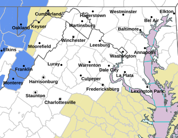
FREEZING RAIN ADVISORY IN EFFECT FROM 6 PM THIS EVENING TO 1 AM EST WEDNESDAY
URGENT – WINTER WEATHER MESSAGE
NATIONAL WEATHER SERVICE BALTIMORE MD/WASHINGTON DC
132 PM EST TUE JAN 10 2017
EXTREME WESTERN ALLEGANY-CENTRAL AND EASTERN ALLEGANY-
NORTHWEST MONTGOMERY-NORTHWEST HOWARD-NORTHWEST HARFORD-AUGUSTA-
ROCKINGHAM-SHENANDOAH-FREDERICK VA-PAGE-WARREN-CLARKE-NELSON-
ALBEMARLE-GREENE-MADISON-RAPPAHANNOCK-NORTHERN FAUQUIER-
WESTERN HIGHLAND-EASTERN HIGHLAND-WESTERN LOUDOUN-EASTERN LOUDOUN-
NORTHERN VIRGINIA BLUE RIDGE-CENTRAL VIRGINIA BLUE RIDGE-
HAMPSHIRE-MORGAN-BERKELEY-JEFFERSON-HARDY-WESTERN GRANT-
EASTERN GRANT-WESTERN MINERAL-EASTERN MINERAL-WESTERN PENDLETON-
EASTERN PENDLETON-
132 PM EST TUE JAN 10 2017
…FREEZING RAIN ADVISORY IN EFFECT FROM 6 PM THIS EVENING TO
1 AM EST WEDNESDAY…
THE NATIONAL WEATHER SERVICE IN BALTIMORE MD/WASHINGTON HAS
ISSUED A FREEZING RAIN ADVISORY…WHICH IS IN EFFECT FROM 6 PM
THIS EVENING TO 1 AM EST WEDNESDAY.
* HAZARD TYPES…FREEZING RAIN.
* ICE ACCUMULATIONS…LESS THAN A TENTH-INCH.
* TIMING…SPREADING WEST TO EAST BETWEEN 6PM AND 9PM. GRADUALLY
CHANGING TO RAIN BETWEEN 10PM AND 1AM, INITIALLY EAST OF THE
BLUE RIDGE AND ALONG THE APPALACHIANS…AND LINGERING THE
LONGEST IN THE SHENANDOAH VALLEY.
* IMPACTS…ICE ACCUMULATION ON ANY UNTREATED SURFACE. ROADS AND
WALKWAYS WILL BE SLIPPERY.
* WINDS…SOUTH 10 TO 15 MPH. GUSTS ALONG THE RIDGES TOPS UP TO
30 MPH.
* TEMPERATURES…UPPER 20S AND LOWER 30S.
PRECAUTIONARY/PREPAREDNESS ACTIONS…
A FREEZING RAIN ADVISORY MEANS THAT PERIODS OF FREEZING RAIN OR
FREEZING DRIZZLE WILL CAUSE TRAVEL DIFFICULTIES. BE PREPARED FOR
SLIPPERY ROADS. SLOW DOWN AND USE CAUTION WHILE DRIVING.

Debbie Wilson in Piney River of Nelson County. Just about 3.5" pic.twitter.com/PxVUc7OmlU
— BlueRidgeLife (@BlueRidgeLife) January 7, 2017
Central Virginia Blue Ridge
Skies have cleared and the temps have bottomed out as the first significant snow of the season has moved offshore. We still have a couple of cold days ahead, but a tremendous warming trend is on the way toward for the second half of the week.
Here’s a few of your pictures and comments from the most recent storm.
Dima Holmes says Devils Knob up @WintergreenVA has 7" of new snow as of this morning. pic.twitter.com/YbJErCZuMs
— Tommy Stafford (@thstaff) January 7, 2017
Another report by @jstwg up on Devils Knob @WintergreenVA 7" of snow. pic.twitter.com/j5GH1W5qgW
— BlueRidgeLife (@BlueRidgeLife) January 7, 2017
FB Friend Jody Morgan : City of Lexington pic.twitter.com/whFA6hMzfs
— BlueRidgeLife (@BlueRidgeLife) January 7, 2017
FB friend Vickie Wilkerson : "29/151. Roads aren't too bad about 40 MPH not hitting brakes. Actually worse where they've melted A&R slushie" pic.twitter.com/eBdupWgpF1
— BlueRidgeLife (@BlueRidgeLife) January 7, 2017
FB friend Megan Siegel : "3" here in Nellysford!" pic.twitter.com/0ZZaYF8E2K
— BlueRidgeLife (@BlueRidgeLife) January 7, 2017
FB friend Rosemary Nichols: "Off my back porch at the Swannanoa golf course…still coming down" pic.twitter.com/C7xDc2fwq8
— BlueRidgeLife (@BlueRidgeLife) January 7, 2017
Town of Amherst: Via FB friend Pamela Campbell pic.twitter.com/F13YCMidGk
— BlueRidgeLife (@BlueRidgeLife) January 7, 2017
FB friend Clay Lawson reporting about 3" of snow in Schuyler of E Nelson Co this AM. pic.twitter.com/RdXoFlB1ZG
— BlueRidgeLife (@BlueRidgeLife) January 7, 2017

VDOT CREWS IN WINTER WEATHER RESPONSEMotorists urged to avoid travel during icy, snowy road conditions
LYNCHBURG – While most people were safe and warm in their beds, crews from the Lynchburg District of the Virginia Department of Transportation (VDOT) and other locations across the state dealt with the bulk of this major winter storm and snow will continue to fall in many areas throughout today. VDOT continues to urge motorists to avoid travel during icy, snowy road conditions.
Motorists are reminded that snowplow operators will work on primary routes (those numbered 1-599) until winter weather has ended and major roads are treated with a goal to have all state-maintained roadways passable with 48 hours after a storm has ended. Passable does not necessarily mean the road will be clear and with temperatures expected to be below freezing into next week, it is likely that some snow/ice will remain on surfaces.
Traffic alerts and traveler information are available at www.511Virginia.org, on VDOT’s 511 mobile app or by calling 511 from any phone in Virginia. Updates are available by following the Lynchburg District on Twitter at @VaDOTLynchburg. Additional information is also available on VDOT’s webpage at www.VirginiaDOT.org.
Weather related road issues can be reported by calling 800-FOR-ROADS (800-367-7623) or by going to https://my.vdot.virginia.gov/.
The Lynchburg District includes the counties of Amherst, Appomattox, Buckingham, Campbell, Charlotte, Cumberland, Halifax, Nelson, Pittsylvania and Prince Edward.

!EXPIRED – EXPIRED – EXPIRED!
!EXPIRED – EXPIRED – EXPIRED!
!EXPIRED – EXPIRED – EXPIRED!
WINTER WEATHER ADVISORY IN EFFECT FROM 1 AM TO 1 PM EST SATURDAY
URGENT – WINTER WEATHER MESSAGE
NATIONAL WEATHER SERVICE BALTIMORE MD/WASHINGTON DC
459 PM EST FRI JAN 6 2017
VAZ025-036>039-050-055>057-507-508-070600-
/O.CON.KLWX.WW.Y.0002.170107T0600Z-170107T1800Z/
AUGUSTA-NELSON-ALBEMARLE-GREENE-MADISON-ORANGE-STAFFORD-
SPOTSYLVANIA-KING GEORGE-NORTHERN VIRGINIA BLUE RIDGE-
CENTRAL VIRGINIA BLUE RIDGE-
459 PM EST FRI JAN 6 2017
…WINTER WEATHER ADVISORY REMAINS IN EFFECT FROM 1 AM TO 1 PM
EST SATURDAY…
* PRECIPITATION TYPE…SNOW.
* ACCUMULATIONS…SNOW ACCUMULATION OF 1 TO 3 INCHES.
* TIMING…OVERNIGHT THROUGH EARLY SATURDAY AFTERNOON.
* IMPACTS…SNOW ON ROADS WILL RESULT IN TRAVEL IMPACTS.
* WINDS…NORTH 10 TO 15 MPH WITH GUSTS UP TO 25 MPH.
* TEMPERATURES…IN THE MID 20S.
PRECAUTIONARY/PREPAREDNESS ACTIONS…
A WINTER WEATHER ADVISORY FOR SNOW MEANS THAT PERIODS OF SNOW
WILL CAUSE PRIMARILY TRAVEL DIFFICULTIES. BE PREPARED FOR SNOW
COVERED ROADS AND LIMITED VISIBILITIES…AND USE CAUTION WHILE
DRIVING.
URGENT – WINTER WEATHER MESSAGE
NATIONAL WEATHER SERVICE BLACKSBURG VA
347 PM EST FRI JAN 6 2017
…SIGNIFICANT SNOWFALL TONIGHT INTO EARLY SATURDAY…
…VERY COLD WIND CHILLS SATURDAY THROUGH SUNDAY…
.LOW PRESSURE WILL DEVELOP ACROSS THE GULF COAST STATES AND THEN
MOVE NORTHEAST ALONG THE ATLANTIC COAST LATER TONIGHT INTO
SATURDAY. PRECIPITATION ON THE NORTHWEST SIDE OF THIS SYSTEM WILL
SPREAD MEASURABLE SNOWFALL INTO THE REGION. THE GREATEST AMOUNTS
ARE EXPECTED OVER PARTS OF SOUTHSIDE VIRGINIA… NORTH CENTRAL
NORTH CAROLINA….AND THE FOOTHILLS. BEHIND THIS SYSTEM…THE
COMBINATION OF STRONG AND GUSTY WINDS AND FALLING TEMPERATURES
INTO THE SINGLE DIGITS…WILL YIELD WIND CHILLS ACROSS MANY PARTS
OF THE AREA BETWEEN 5 TO 15 DEGREES BELOW ZERO.
VAZ035-047-070500-
/O.CON.KRNK.WW.Y.0002.170107T0000Z-170108T0000Z/
AMHERST-BUCKINGHAM-
INCLUDING THE CITY OF…AMHERST
347 PM EST FRI JAN 6 2017
…WINTER WEATHER ADVISORY REMAINS IN EFFECT FROM 7 PM THIS
EVENING TO 7 PM EST SATURDAY…
* LOCATIONS…AMHERST AND BUCKINGHAM COUNTIES IN VIRGINIA.
* HAZARD TYPES…SNOW.
* ACCUMULATIONS…2 TO 4 INCHES.
* TIMING…LATE THIS EVENING INTO SATURDAY MORNING.
* IMPACTS…SNOW COVERED AND SLICK ROADS…HAZARDOUS TRAVEL
CONDITIONS.
* TEMPERATURES…FALLING INTO THE 20S OVERNIGHT.
PRECAUTIONARY/PREPAREDNESS ACTIONS…
A WINTER WEATHER ADVISORY FOR SNOW MEANS THAT PERIODS OF SNOW
WILL CAUSE TRAVEL DIFFICULTIES. BE PREPARED FOR SNOW COVERED
ROADS AND LIMITED VISIBILITIES…AND USE CAUTION WHILE DRIVING.
URGENT – WINTER WEATHER MESSAGE
NATIONAL WEATHER SERVICE BLACKSBURG VA
347 PM EST FRI JAN 6 2017
…SIGNIFICANT SNOWFALL TONIGHT INTO EARLY SATURDAY…
…VERY COLD WIND CHILLS SATURDAY THROUGH SUNDAY…
.LOW PRESSURE WILL DEVELOP ACROSS THE GULF COAST STATES AND THEN
MOVE NORTHEAST ALONG THE ATLANTIC COAST LATER TONIGHT INTO
SATURDAY. PRECIPITATION ON THE NORTHWEST SIDE OF THIS SYSTEM WILL
SPREAD MEASURABLE SNOWFALL INTO THE REGION. THE GREATEST AMOUNTS
ARE EXPECTED OVER PARTS OF SOUTHSIDE VIRGINIA… NORTH CENTRAL
NORTH CAROLINA….AND THE FOOTHILLS. BEHIND THIS SYSTEM…THE
COMBINATION OF STRONG AND GUSTY WINDS AND FALLING TEMPERATURES
INTO THE SINGLE DIGITS…WILL YIELD WIND CHILLS ACROSS MANY PARTS
OF THE AREA BETWEEN 5 TO 15 DEGREES BELOW ZERO.
VAZ024-070500-
/O.EXT.KRNK.WW.Y.0002.170107T0000Z-170108T0000Z/
ROCKBRIDGE-
INCLUDING THE CITIES OF…LEXINGTON…BUENA VISTA
347 PM EST FRI JAN 6 2017
…WINTER WEATHER ADVISORY NOW IN EFFECT FROM 7 PM THIS EVENING
TO 7 PM EST SATURDAY…
* LOCATIONS…SOUTHWEST MOUNTAINS IN VIRGINIA.
* HAZARD TYPES…SNOW.
* ACCUMULATIONS…2 TO 5 INCHES IN THE HIGHER ELEVATIONS.
* TIMING…THIS EVENING INTO EARLY SATURDAY MORNING.
* IMPACTS…SNOW COVERED AND SLICK ROADS…HAZARDOUS TRAVEL
CONDITIONS.
* TEMPERATURES…FALLING INTO THE TEENS AND LOWER 20S TONIGHT.
PRECAUTIONARY/PREPAREDNESS ACTIONS…
A WINTER WEATHER ADVISORY FOR SNOW MEANS THAT PERIODS OF SNOW
WILL CAUSE TRAVEL DIFFICULTIES. BE PREPARED FOR SNOW COVERED
ROADS AND LIMITED VISIBILITIES…AND USE CAUTION WHILE DRIVING.

Above Meteorologist David Reese at CBS-19 with the latest as of 6PM Friday.
VDOT Latest Road Prep Info:
VDOT CREWS AT THE READY
Motorists urged to avoid travel during icy, snowy road conditions
LYNCHBURG – An initial blast of snow from the storm expected to end Saturday afternoon has fallen across the Lynchburg District of the Virginia Department of Transportation (VDOT). While the bulk the storm will follow, motorists are currently being urged to avoid travel during icy, snowy road conditions.
VDOT crews pre-treated the most heavily traveled roads across the Lynchburg District in anticipation of this storm. This treatment is used to weaken the bond snow/ice has on surfaces and allows highway crews additional time to work roads and structures.
Motorists are reminded that snowplow operators working 12-hour shifts will work on primary routes (those numbered 1-599) until winter weather has ended and major roads are treated. VDOT’s goal is to have all state-maintained roadways passable with 48 hours after a storm has stopped. Passable does not necessarily mean the road will be clear of all frozen precipitation and with temperatures expected to be below freezing into next week, it is likely that some snow/ice will remain on surfaces.
For traffic alerts and traveler information, visit www.511Virginia.org, VDOT’s 511 mobile app or call 511 from any phone in Virginia. Updates are available by following the Lynchburg District on Twitter at @VaDOTLynchburg. Additional information is also available on VDOT’s webpage at www.VirginiaDOT.org.
The Lynchburg District includes the counties of Amherst, Appomattox, Buckingham, Campbell, Charlotte, Cumberland, Halifax, Nelson, Pittsylvania and Prince Edward.

Central Virginia Blue Ridge Area
Via our media partners over at CBS19 The Weather Authority:
“Regarding Thursday night / Friday morning: very little snow, but timing could make for slippery roads on the Friday morning commute.”


Nelson County, Virginia
A little over a year ago back in November of 2015 we told you about a challenge by E & J Gallo Wines of California against local kombucha entrepreneurs Ethan and Kate Zuckerman over the use of the name Barefoot Bucha. Fast forward to August 2016, the two companies reached an agreement where Barefoot would change its name.
Today Conscious Cultures, LLC, that produces the kombucha product from here in Nelson County, announced the new name.
The new name was selected by running a crowd-source naming contest that received over 500 entries. Says Ethan Zuckerman, Co-Owner of Blue Ridge Bucha, “When we started looking at all the entries coming in, we noticed a distinct pattern: one in five contest entrants suggested Blue Ridge Bucha. This really struck us, because we weren’t asking people to vote on options we presented—we were asking for original entries and a significant percentage of people were submitting the same thing. We also realized that when you search the internet for Blue Ridge Bucha we’re the first few pages of entries that come up—there is already a close association with our kombucha and the Blue Ridge Mountains where we live and brew it.”

Adds his wife Kate, Co-Owner of the company, “We love that our community picked the name—it just feels right given our deep roots here. There were a lot of creative names submitted, but the beverage space is going through a bit of a crisis with trademark litigation right now. That’s definitely not something we want to go through twice and picking a place name gives us certain protections from that. We are also committed to a low carbon footprint, which means we only distribute to a small geographic area in and around the Blue Ridge. The more we thought about it, the more Blue Ridge Bucha became the obvious choice.”
Because so many contest entrants picked the same name, the Zuckermans literally drew a name out of a hat to determine who would receive the grand prize: a year’s supply of kombucha. The winner, who lives in Charlottesville, VA., will enjoy a growler fill each week for a year, courtesy of Barefoot Bucha and Whole Foods Charlottesville.
On Sunday, January 15th, Whole Foods Charlottesville will be hosting a party for the official launch of the new brand. It will take place from 3-5pm. There will be food, live music, and attendees will receive a new 32 oz mini growler from Blue Ridge Bucha. All are welcome.

Blue Ridge Bucha is a family-owned small business that is known for its innovative, sustainable method of getting its product to the market. The company has set up various fountains in Virginia, Maryland, and Washington, D.C., where customers can get fresh, Certified Organic kombucha on draft. Customers buy a bottle, which they then own, and can refill as many times as they want. Since 2010, kombucha drinkers have saved over half a million bottles through the company’s refillable bottle program.
For more information, follow Barefoot Bucha on Facebook or visit http://www.barefootbucha.com


Nelson County, Virginia
One year ago today we told you about the tragic death of 21 year old Daniel Rasnake. He had wrecked his car on Route 6 River Road very early that morning. He managed to get out of the car, call for help and make it up to the highway. That’s when he was hit by a passing vehicle. It is believed Rasnake was struck by a large and/or commercial vehicle. He died at the scene.
Today the Virginia State Police tell us they are still working the case.
“The investigation remains ongoing at this time. No arrests or charges to report,”
Corrine Geller the Public Relations Director for VSP told us late Friday afternoon.
Anyone with information is still asked to contact the Virginia State Police Appomattox Division at 434-352-7128 or on a cell phone at #77 or by email at questions@vsp.virginia.gov.

EXPIRED – EXPIRED – EXPIRED
EXPIRED – EXPIRED – EXPIRED
EXPIRED – EXPIRED – EXPIRED
WIND ADVISORY REMAINS IN EFFECT UNTIL 6 PM EST THIS EVENING
URGENT – WEATHER MESSAGE
NATIONAL WEATHER SERVICE BALTIMORE MD/WASHINGTON DC
945 AM EST FRI DEC 30 2016
EASTERN HIGHLAND-NORTHERN VIRGINIA BLUE RIDGE-
CENTRAL VIRGINIA BLUE RIDGE-EASTERN GRANT-EASTERN PENDLETON-
INCLUDING THE CITIES OF…MONTEREY…BIG MEADOWS…WINTERGREEN…
PETERSBURG…BRANDYWINE…FRANKLIN…OAK FLAT…RUDDLE…
SUGAR GROVE
945 AM EST FRI DEC 30 2016
…WIND ADVISORY REMAINS IN EFFECT UNTIL 6 PM EST THIS EVENING…
* TIMING…THROUGH THIS EVENING.
* WINDS…WEST 20 TO 30 MPH WITH GUSTS AROUND 50 MPH.
* IMPACTS…STRONG WINDS MAY BLOW DOWN LIMBS…TREES…AND POWER
LINES. SCATTERED POWER OUTAGES ARE EXPECTED.
PRECAUTIONARY/PREPAREDNESS ACTIONS…
A WIND ADVISORY MEANS THAT WINDS AROUND 50 MPH ARE EXPECTED.
WINDS THIS STRONG CAN MAKE DRIVING DIFFICULT…ESPECIALLY FOR
HIGH PROFILE VEHICLES.
URGENT – WEATHER MESSAGE
NATIONAL WEATHER SERVICE BLACKSBURG VA
438 AM EST FRI DEC 30 2016
…STRONG NORTHWEST WINDS WILL CONTINUE INTO THIS EVENING…
.MUCH COLDER AIR WILL CONTINUE TO SURGE INTO THE AREA IN THE WAKE
OF A COLD FRONT TODAY. THIS WILL COMBINE WITH AN INCREASING
PRESSURE GRADIENT TO KEEP PERIODS OF VERY STRONG NORTHWEST WINDS
GOING INTO THIS EVENING.
ASHE-ALLEGHANY NC-WATAUGA-SMYTH-BLAND-GILES-WYTHE-PULASKI-
MONTGOMERY-GRAYSON-CARROLL-FLOYD-CRAIG-ALLEGHANY VA-BATH-ROANOKE-
BOTETOURT-ROCKBRIDGE-PATRICK-FRANKLIN-BEDFORD-AMHERST-
INCLUDING THE CITIES OF…WEST JEFFERSON…SPARTA…BOONE…
MARION…BLAND…PEARISBURG…WYTHEVILLE…RADFORD…PULASKI…
BLACKSBURG…INDEPENDENCE…WHITETOP…TROUTDALE…VOLNEY…
GALAX…FLOYD…NEW CASTLE…CLIFTON FORGE…COVINGTON…
HOT SPRINGS…ROANOKE…SALEM…FINCASTLE…LEXINGTON…
BUENA VISTA…STUART…ROCKY MOUNT…BEDFORD…AMHERST
438 AM EST FRI DEC 30 2016
…WIND ADVISORY REMAINS IN EFFECT UNTIL 6 PM EST THIS EVENING…
* LOCATIONS…ALONG AND EITHER SIDE OF THE BLUE RIDGE.
* HAZARDS…VERY STRONG WINDS.
* WINDS…WEST WINDS 15 TO 30 MPH WITH GUSTS UP TO 55 MPH.
LOCALLY STRONGER WINDS POSSIBLE ALONG THE HIGHER RIDGETOPS.
* TIMING…INTO THIS EVENING.
* IMPACTS…STRONG WINDS COULD TOPPLE TREES AND POWER LINES.
HOLIDAY DECORATIONS COULD BE BLOWN OVER.
PRECAUTIONARY/PREPAREDNESS ACTIONS…
A WIND ADVISORY IS ISSUED WHEN SUSTAINED WINDS ARE FORECAST TO BE
31 TO 39 MPH OR GUSTS WILL RANGE BETWEEN 46 AND 57 MPH. WINDS OF
THESE MAGNITUDES MAY CAUSE MINOR PROPERTY DAMAGE WITHOUT EXTRA
PRECAUTIONS. MOTORISTS IN HIGH PROFILE VEHICLES SHOULD USE EXTRA
CAUTION UNTIL THE WINDS SUBSIDE.
