A few flowers have already been blooming due to the really warm weather we’ve had over the past month. They can make it official now. Spring arrives at 6:29 AM EDT Monday – March 20, 2017
Central Virginia Blue Ridge
Some folks would even question whether we’ve actually had winter this year, but in spite of lackluster snowfall and temps warmer than average, we did have our share of cold nights. Regardless, the calendar doesn’t lie and spring 2017 rolls in officially at 6:29 AM EDT Monday – March 20, 2017.
Press Release Via Nelson County Sheriff’s Department:
“On March 19, 2017, the Nelson County Sheriff’s Office responded to an armed home invasion which occurred in the 4000 block of Glade Road. The suspect, later identified as Matthew Baber age 26 of Schuyler, entered the home of the victim armed with a handgun. During the initial confrontation the victim was able to notify the Nelson Sheriff’s Office who quickly responded to the scene. Baber was taken into custody a short time later and charged with breaking and entering with the intent to commit robbery and the use of a firearm during the commission of a felony. Baber is currently being held without bond. The victim was not injured during the incident. No further information is being released at this time.”
Robert New, Capt
Nelson County Sheriff’s Department
Lovingston, Virginia
Friday we welcomed our newest WeatherNow station to our BRL network of weather stations. Those stations provide real time weather weather conditions at several locations. The BRL-Ski Barn station went online early Friday afternoon and joins our three other stations, two of which have been online for over 10 years.
Above, live data from our newest BRL WeatherNow station at The Ski Barn in Beech Grove / Roseland at the intersection of Route 151 & 664 Click on the icon for even more information.
Above Nikki Chambers, manager at The Ski Barn, holds up the internal display unit that pushes live weather data out to the internet.Way up there on the roof at The Ski Barn, Tommy & Clayton put the finishing touches on the latest WeatherNow station in Beech Grove : Friday – March 17, 2017.
We’ll be adding more stations in the near future and look for another big announcement coming within the next few weeks that’s really going to be very cool!
Greg Kelly, Central Virginia Electric Cooperative (CVEC) Communications and Public Relations Manager, seen here in this photo from 2011. Today on Friday – March 17, 2017 Greg will be retiring from the electric cooperative.
Publisher’s Note:
Today we say farewell to a person that’s not only been a regular contact for us here at BRL, but a person that’s become a friend over the years. You’ve seen his name a thousand times during our 12 year history. Remember Derecho 5 years ago this June? That’s just one event where it seems like we talked to Greg every hour for two weeks! Greg was always there to tell us when the lights were coming back on.
Today we say so long to our colleague and friend as he retires from CVEC this afternoon.
Below, Jennie Williams story on Greg.
Arrington
Nelson County, Virginia By Jennie T. Williams
“I don’t plan to retire,” he said, though his last day as a full time CVEC employee is still today. “And anyone that I’ve known who said they were going to retire is back to work or doing consulting or special projects within six months. I think I will focus on projects that allow me to use my communications and public relations skills.”
Greg began his journey with CVEC on September 18, 1998, but his journey to Nelson County began a decade earlier when, after his company transferred him to Cleveland, he decided life was to short to spend it somewhere he didn’t love. And Ohio, as he put it, was not his cup of tea.
“So I decided to move where I wanted to live my entire life rather than waiting for retirement,” said Greg, who is also a member of the county’s Economic Development Authority. “I had been to Wintergreen so I got a job over the phone and worked [at the resort] until 1988 when I started working for Candidate and then Congressman L.F. Payne [Jr.].”
Greg then spent 10 years working for Representative Payne as his District Director of Economic Development. But living in Wintergreen and commuting to Charlottesville every day began to take its toll and when the opportunity to work locally arose, he jumped at the chance.
And he counts his blessings that his career led him where it did – he truly believes in CVEC’s mission and will continue his work improving Nelson County even during “retirement.”
“Ninety percent of Virginia did not have electricity at one point in time and there are people who still remember that,” said Greg about why he was excited to get up and go to work every day. “Now people can live – due to rural electrification – comfortably. They have efficiency and comfort and convenience and help. Being part of that overall process and being able to tell that story has its intrinsic rewards.”
Greg in 1999 talking with folks about CVEC.
Greg knows that electricity is both important because we need and that we need it because it’s important. And he is glad that the Co-op continues to keep electricity costs low to make sure it’s a utility that everyone has access to.
In 1937, he said, a kilowatt hour cost just five cents (and when an outage happened, folks sent a penny post card to report it). These days – eight decades later – the price of a kilowatt hour is only 12 cents (and you can bet every one of those cents that every iPhone in the outage area will be calling when there’s an outage).
“So over 80 years, it double-plus, while other things are ten to 50 time as expensive. And we’ve worked really diligently to maintain that position. Energy needs to be affordable,” he said, adding that the Co-op has done quite a few things in recent years to drive down the outage minutes. “And they have a really good plan to get power back on as quickly as possible. So affordable energy and high reliability are top priorities for the Co-op and I am very pleased to have seen those grown and improve during my time.”
“If I can offer this as an unsolicited compliment, you (Tommy) and Yvette do a great job in keeping in touch with people in Nelson and surrounding counties. I think you provide a great service. You are consistently professional and always there.”
Publisher’s ending comment:
We can’t say enough good things about Greg. Though we won’t be seeing him any longer at CVEC in his official capacity, he tells us he will be staying in Nelson. We look forward to many more years of great friendship with a person that took us under his wing long ago and helped our magazine become what it is today. Happy Trails Greg, and see you around the county! Tommy & Yvette
The Virginia Department of Transportation is performing bridge work on the Interstate 64 westbound bridge over Route 763 (Lincoln Road) and Mill Creek in Rockbridge County. This location is on I-64 between exit 56 at Interstate 81 and exit 55 at Route 11 in Lexington.
Beginning March 20 at 8 p.m. crews will begin steel beam welding operations, which helps to maintain the bridge’s service life. The welding work requires a 24 hour-a-day total bridge closure. Because of this work I-81 exit 191 westbound at I-64 will be closed.
Northbound and southbound traffic on I-81 headed westbound on I-64 will use I-81 exit 195 and take Route 11 southbound to the I-64 exit 55 interchange. This detour will begin on March 20 at 8 p.m. and last approximately three to six days, depending on project progress.
All work is weather permitting.
Traffic alerts and traveler information can be obtained by dialing 511. Traffic alerts and traveler information also are available at http://www.511Virginia.org.
The VDOT Customer Service Center can assist with reporting road hazards, asking transportation questions, or getting information related to Virginia’s roads. Call 800-FOR- ROAD (800-367-7623) or use its mobile friendly website at https://my.vdot.virginia.gov/. Agents are available 24 hours-a-day, seven days a week.
The Staunton District Twitter feed is at @VaDOTStaunton. VDOT can be followed on Facebook, Flickr, Twitter and YouTube. RSS feeds are also available for statewide information. The VDOT Web page is located at http://www.VirginiaDOT.org.
The VDOT Staunton District serves Frederick, Shenandoah, Clarke, Warren, Page, Rockingham, Augusta, Highland, Rockbridge, Alleghany and Bath counties.
Thanks to Stuart Smith for this photo. Snow and ice covered areas in the higher elevations of Nelson County. This is a shot from Wintergreen Resort where roughly 2-3 inches of snow, ice and sleet fell Tuesday – March 14, 2017.
Wintergreen Resort
Nelson County, Virginia
While the much hyped snow by some was pretty much a bust in the lowlands of Central Virginia, that wasn’t the case in the higher elevations at places like Wintergreen Resort. But even there it was a mix of freezing rain, sleet and snow totaling about 3-4 inches.
To see more photos from up top at Wintergreen, click on our Facebook album above.Photo By Curtis Lawhorne : Just before daylight Tuesday the roads in the higher elevations leading to Wintergreen were ice and snow covered. They have since been cleared by road crews. March 14, 2017
The rest of this week will be cold but no chances for any wintry weather to speak of. By late into the weekend we finally get back to more seasonal temps you’d expect to see for the final days of winter. Spring officially begins March 20th at 6:29 AM EDT.
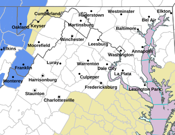
Via NWS : Click on image above for the absolute latest updates for your area from NWS.
4:50 AM – 3.14.17
WINTER WEATHER ADVISORY DROPPED FOR NELSON & ALBEMARLE LOWLANDS. SOME WARNINGS DOWNGRADED. FOR LATEST INFO SPECIFIC TO YOUR AREA, CLICK ON THE NWS MAP ABOVE.
Older original posts. URGENT – WINTER WEATHER MESSAGE
National Weather Service Baltimore MD/Washington DC
518 PM EDT Mon Mar 13 2017
Central and Eastern Allegany-Augusta-Rockingham-Shenandoah-Page-
Eastern Highland-Central Virginia Blue Ridge-Hampshire-Hardy-
Eastern Grant-Eastern Mineral-Eastern Pendleton-
518 PM EDT Mon Mar 13 2017
…WINTER STORM WARNING REMAINS IN EFFECT UNTIL 2 PM EDT
TUESDAY…
* PRECIPITATION TYPE…Snow.
* ACCUMULATIONS…Snow accumulation of 4 to 8 inches, with
locally higher amounts, especially along the ridges.
* TIMING…Snow will overspread the area this evening and
persist through Tuesday morning. The heaviest snow will be
between 10 PM and 6 AM.
* IMPACTS…The heavy snow will create difficult travel
conditions and may produce scattered power outages.
* WINDS…Northeast 5 to 10 mph with gusts up to 20 mph.
* TEMPERATURES…In the upper 20s.
PRECAUTIONARY/PREPAREDNESS ACTIONS…
A Winter Storm Warning for heavy snow means severe winter weather
conditions are expected or occurring. Significant amounts of snow
are forecast that will make travel dangerous. Only travel in an
emergency. If you must travel, keep an extra flashlight, food,
and water in your vehicle in case of an emergency.
URGENT – WINTER WEATHER MESSAGE
National Weather Service Blacksburg VA
355 PM EDT Mon Mar 13 2017
…Winter Storm expected late this afternoon through Tuesday
Night…
.Low pressure will develop off the southeast coast later today
and deepen as it moves northeast along the coast overnight into
Tuesday. Behind this system upslope snow will persist over the
western mountains into Tuesday night.
Alleghany VA-Bath-Rockbridge-Amherst-Eastern Greenbrier-
Including the cities of Clifton Forge, Covington, Hot Springs,
Lexington, Buena Vista, Amherst, Lewisburg,
and White Sulphur Springs
355 PM EDT Mon Mar 13 2017
…WINTER STORM WARNING REMAINS IN EFFECT UNTIL 2 PM EDT
TUESDAY…
* Locations…From the Greenbrier Valley east to the Blue Ridge
of Amherst County, including the Alleghany Highlands and
Southern Shenandoah Valley.
* Hazard types…Snow. Snow will be mixed with sleet at times
tonight.
* Accumulations…Snow accumulation of 3 to 8 inches.
* Timing…Early this evening through midday Tuesday.
* Impacts…Snow will create hazardous travel conditions with
snow covered roads. Power outages could occur due to the heavy
wet snow.
* Winds…North 5 to 15 mph with gusts up to 30 mph.
* Temperatures…Dropping into the mid 20s to lower 30s tonight.
URGENT – WINTER WEATHER MESSAGE
National Weather Service Baltimore MD/Washington DC
518 PM EDT Mon Mar 13 2017
Prince Georges-Anne Arundel-Charles-Nelson-Albemarle-Orange-
Stafford-Spotsylvania-
518 PM EDT Mon Mar 13 2017
…WINTER WEATHER ADVISORY REMAINS IN EFFECT UNTIL 2 PM EDT
TUESDAY…
* PRECIPITATION TYPE…Snow mixed with sleet.
* ACCUMULATIONS…Snow and sleet accumulation of 2 to 5 inches,
with the highest amounts in the northern and western portions
of these counties.
* TIMING…Snow will overspread the area this evening and
persist through Tuesday morning. Sleet will mix in late
tonight into Tuesday morning.
* IMPACTS…The snow and sleet will create slippery travel
conditions.
* WINDS…North 10 to 20 mph with gusts up to 30 mph.
* TEMPERATURES…In the low to mid 30s.
PRECAUTIONARY/PREPAREDNESS ACTIONS…
A Winter Weather Advisory means that periods of snow and sleet
will cause travel difficulties. Be prepared for slippery roads
and limited visibilities, and use caution while driving.
Photos courtesy of Kaleigh Smith and team : Kaleigh Smith of Roseland, Virginia and a 2nd year nursing student at UVA, stands atop one of the many slopes in Bend, Oregon at the United States Collegiate Ski & Snowboard Association national championships.
Bend, Oregon &
Roseland, Virginia
“I was overjoyed when I found out I placed 5th, that was definitely the highlight of my week and the event I felt most confident in. I am so proud of my team for taking home 3rd overall in the nation, everyone really pulled their weight and it showed at the end of the week.” That’s how Kaleigh Smith of Roseland in Nelson County, Virginia described her week out in Bend, Oregon as part of the 12 UVA students that took part in the Alpine Ski & Snowboard Association Nationals. (VASST) She talked to us early Sunday evening just after touching back down at Reagan International from her flight back east.
Kaleigh Smith of Roseland, Virginia receiving her award. She placed 5th overall in the nation for rail jam.The team of 12 – representing The University of Virginia and the southeast conference with their plates (awards) out in Bend, Oregon. They placed 3rd overall in the nationals. The UVA team is part of a conference they refer to as the “Dirty South.”
“This year was my first time at regionals and nationals and also my first time out west! Bachelor got 3 feet of snow throughout the week and 29 inches in the first 3 days. Riding in powder like that was incredible. We did get one day of rain but it cleared up Friday and Mt.Bachelor is absolutely spectacular. I’m extremely thankful for my team and family for helping make this trip possible and was really proud to represent UVA at such a big competition,” Kaleigh continued.
Kaleigh Smith of Roseland, Virginia doing her thing at a rail jam earlier in the season at Bryce Resort.The UVA team is part of the Southeast Conference. They refer to themselves as Dirty South.The lady boarders from the UVA team this past week out in Bend, Oregon. Kaleigh Smith of Roseland, Virginia is in the center – back.One of the views from the slopes in Bend, Oregon at this past week’s competition.
Kaleigh tells us she started snowboarding in late middle school and really got into park (terrain park) in high school. She didn’t start competing until college. And what’s next? “I’ll keep going to snowflex at Liberty to keep learning new tricks during the off season and for now, hope for more snow!”
BlueRidgeLife™2013 : Photo By Tommy Stafford : A VDOT plow pushes snow off of Route 151 in Afton just north of Nellysford, VA in this file photo from – Sunday afternoon March 24, 2013
Via VDOT Staunton:
IT’S GOING TO SNOW – SHOULD YOU STAY OR SHOULD YOU GO
Heavy snow is predicted for the Shenandoah Valley, beginning late on Monday afternoon and will continue throughout the night. People should prepare to avoid travel and shelter in place during the storm. The Virginia Department of Transportation advises the public to plan their travel now before Monday afternoon commuting hours to ensure they are at a destination where travel will not be necessary late Monday.
VDOT and contractor crews have spent Sunday preparing for the storm. Anti-icing operations began early on Sunday morning in the Shenandoah Valley. Crews will be deployed and staged on Monday prior to the precipitation beginning. VDOT has enough materials and chemicals to treat area roads throughout the weather event.
Road temperatures are forecasted to be above freezing when the snow begins. Initially snow may just melt on the road surfaces, but elevated surfaces such as ramps and bridges will freeze first and extra caution should be used when traveling in these areas.
The Virginia Department of Transportation has a variety of road condition and information resources.
New this snow season is the My VDOT site which is the web and mobile device interactive platform for the VDOT Customer Service Center. People can go to My.VDOT.Virginia.Gov and report road hazards, ask transportation questions, or get information related to Virginia’s roads. Agents are on site 24/7 every day of the year to assist the public. People can also call the VDOT Customer Service Center at 800-FOR- ROAD (800-367-7623).
For winter weather road conditions go to www.511Virginia.org, look at the orange bar on the top of the page and click on “Text Views” and then click on “Road Condition Table”. Look at the pull down box that lists all jurisdictions. In this box individual counties can be chosen to view.
Traffic alerts and traveler information also are available at http://www.511Virginia.org. On the go? Then visit VDOT’s Free Virginia 511 Tools to get your 511 app for android or iOS. Traffic alerts and traveler information can be obtained by dialing 511.
VDOT statewide Twitter messages can be found at @VaDOT. The nine districts can be found at:Hampton Roads @VaDOTHR; Richmond @VaDOTRVA; Northern Virginia @VaDOTNOVA; Fredericksburg @VaDOTFred; Culpeper @VaDOTCulp; Lynchburg @VaDOTLynchburg; Bristol @VaDOTBristol; Salem @VaDOTSalem; Staunton @VaDOTStaunton.
The VDOT Staunton District serves Frederick, Shenandoah, Clarke, Warren, Page, Rockingham, Augusta, Highland, Rockbridge, Alleghany and Bath counties.
The Staunton District Twitter feed is at @VaDOTStaunton. VDOT can be followed on Facebook, Flickr, Twitter and YouTube. RSS feeds are also available for statewide information. The VDOT Web page is located at http://www.VirginiaDOT.org.
Via NWS Sterling, VA : A WINTER STORM WATCH has been expanded to include additional counties in Central Virginia. Wintergreen Resort & Charlottesville are among some of the locations included. This updates the earlier watch / warnings and expands the coverage area to the south.
URGENT – WINTER WEATHER MESSAGE
National Weather Service Blacksburg VA
1048 PM EDT Sun Mar 12 2017
…Winter Storm expected Monday afternoon through Tuesday Night…
.Low pressure will develop off the southeast coast on Monday and
deepen as it moves northeast along the coast Monday night and
Tuesday. Behind this system upslope snow will persist over
Southeast West Virginia into Tuesday night.
Alleghany VA-Bath-Rockbridge-Amherst-Eastern Greenbrier-
Including the cities of Clifton Forge, Covington, Hot Springs,
Lexington, Buena Vista, Amherst, Lewisburg,
and White Sulphur Springs
1048 PM EDT Sun Mar 12 2017
…WINTER STORM WARNING IN EFFECT FROM 6 PM MONDAY TO 2 PM EDT
TUESDAY…
The National Weather Service in Blacksburg has issued a Winter
Storm Warning for heavy snow, which is in effect from 6 PM Monday
to 2 PM EDT Tuesday. The Winter Storm Watch is no longer in
effect.
* Locations…From the Greenbrier Valley east to the Blue Ridge of
Amherst County, including the Alleghany Highlands and Southern
Shenandoah Valley.
* Hazard types…Snow. Snow will be mixed with sleet at times on
Monday night near the Blue Ridge.
* Accumulations…Snow accumulation of 3 to 6 inches, locally
higher along the ridge tops.
* Timing…Early Monday evening through midday Tuesday.
* Impacts…Snow will create hazardous travel conditions with snow
covered roads.
* Winds…North 5 to 10 mph.
* Temperatures…In the upper 20s to lower 30s.
PRECAUTIONARY/PREPAREDNESS ACTIONS…
A Winter Storm Warning for heavy snow means severe winter weather
conditions are expected or occurring. Significant amounts of snow
are forecast that will make travel dangerous. Only travel in an
emergency. If you must travel…have a winter survival kit with
you.
WINTER STORM WATCH
URGENT – WINTER WEATHER MESSAGE
National Weather Service Baltimore MD/Washington DC
258 PM EDT Sun Mar 12 2017
District of Columbia-Southern Baltimore-Prince Georges-
Anne Arundel-Extreme Western Allegany-
Central and Eastern Allegany-Central and Southeast Montgomery-
Central and Southeast Howard-Southeast Harford-Augusta-Rockingham-
Shenandoah-Page-Nelson-Albemarle-Greene-Madison-Orange-Culpeper-
Prince William/Manassas/Manassas Park-Fairfax-
Arlington/Falls Church/Alexandria-Stafford-Southern Fauquier-
Western Highland-Eastern Highland-Central Virginia Blue Ridge-
Hampshire-Hardy-Western Grant-Eastern Grant-Western Mineral-
Eastern Mineral-Western Pendleton-Eastern Pendleton-
258 PM EDT Sun Mar 12 2017
…WINTER STORM WATCH REMAINS IN EFFECT FROM MONDAY EVENING
THROUGH TUESDAY AFTERNOON…
* PRECIPITATION TYPE…Snow.
* ACCUMULATION…Potential for 5 or more inches of snow within
12 hours. Some locations may see significantly higher
accumulation.
* TIMING…Snow will overspread the area Monday evening and
persist through Tuesday morning.
* IMPACTS…The heavy snow will create difficult travel
conditions and may produce scattered power outages.
* WINDS…Northeast 5 to 10 mph with gusts up to 25 mph.
* TEMPERATURES…In the mid 30s.
PRECAUTIONARY/PREPAREDNESS ACTIONS…
A Winter Storm Watch means there is a potential for significant
snow, sleet, or ice accumulations that may impact travel.
Continue to monitor the latest forecasts.
URGENT – WINTER WEATHER MESSAGE
National Weather Service Blacksburg VA
404 PM EDT Sun Mar 12 2017
…Winter Storm expected Monday afternoon through Tuesday…
.Low pressure will develop off the southeast coast on Monday and
deepen as it moves northeast along the coast Monday night and
Tuesday. At the same time high pressure with cold air will wedge
down the east slopes of the Appalachians Monday and Monday night.
Alleghany VA-Bath-Rockbridge-Amherst-Eastern Greenbrier-
Including the cities of Clifton Forge, Covington, Hot Springs,
Lexington, Buena Vista, Amherst, Lewisburg,
and White Sulphur Springs
404 PM EDT Sun Mar 12 2017
…WINTER STORM WATCH IN EFFECT FROM MONDAY EVENING THROUGH
TUESDAY AFTERNOON…
The National Weather Service in Blacksburg has issued a Winter
Storm Watch, which is in effect from Monday evening through
Tuesday afternoon.
* Locations…Alleghnay Highlands, southern Shenandoah Valley and
eastern Greenbrier County.
* Hazard types…Snow. Snow will be mixed with sleet at times on
Monday night.
* Accumulations…Snow accumulation of 3 to 7 inches. Highest
amounts will be at the higher elevations.
* Timing…starting late Monday afternoon and will continue
through Tuesday morning.
* Impacts…snow and sleet will impact travel including the
evening commute time on Monday and the morning commute on Tuesday.
* Winds…North 5 to 10 mph.
* Temperatures…starting in the mid to upper 30s Monday afternoon
and lowering into the upper 20s to lower 30s Monday night.
PRECAUTIONARY/PREPAREDNESS ACTIONS…
A Winter Storm Watch means there is a potential for significant
snow…sleet…or ice accumulations that may impact travel.
Continue to monitor the latest forecasts.