Photo By Dan Fortune : Traffic was backed up a considerable distance late Thursday afternoon on US 29 SB – North of Route 6 (River Road) where a crash occurred in Woods Mill at the intersection. October 26, 2017
Woods Mill
Nelson County, Virginia
Traffic was delayed Thursday afternoon when a crash occurred at the intersection of River Road & US 29. Crews were working to clear the scene around 5PM and long delays are not expected.
No information on injuries (if any) at this time.
Northbound traffic going past the accident was not affected.
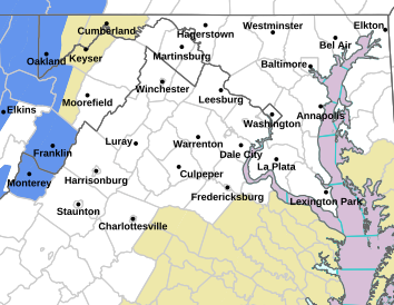
Via NWS : A frost advisory is in effect for many Central Virginia counties overnight Thursday into Friday morning. To the north some counties have a freeze warning in effect.
FROST ADVISORY
URGENT – WEATHER MESSAGE
National Weather Service Baltimore MD/Washington DC
1037 AM EDT Thu Oct 26 2017
District of Columbia-Frederick MD-Carroll-Northern Baltimore-
Southern Baltimore-Prince Georges-Anne Arundel-Charles-St. Marys-
Calvert-Northwest Montgomery-Central and Southeast Montgomery-
Northwest Howard-Central and Southeast Howard-Northwest Harford-
Southeast Harford-Nelson-Albemarle-Greene-Orange-
Prince William/Manassas/Manassas Park-Fairfax-
Arlington/Falls Church/Alexandria-Stafford-Spotsylvania-
King George-Northern Fauquier-Southern Fauquier-Western Loudoun-
Eastern Loudoun-
Including the cities of Washington, Frederick, Ballenger Creek,
Eldersburg, Westminster, Reisterstown, Cockeysville, Baltimore,
Bowie, Suitland-Silver Hill, Clinton, College Park, Greenbelt,
Laurel, Camp Springs, Glen Burnie, Annapolis, Severn, South Gate,
Severna Park, Arnold, Odenton, St. Charles, Waldorf,
Lexington Park, California, Chesapeake Beach, Huntingtown,
Dunkirk, North Beach, Lusby, Prince Frederick, Germantown,
Damascus, Bethesda, Rockville, Gaithersburg, Silver Spring,
Lisbon, Columbia, Ellicott City, Jarrettsville, Aberdeen,
Lovingston, Charlottesville, Stanardsville, Orange, Gordonsville,
Dale City, Manassas, Woodbridge, Lake Ridge, Montclair, Reston,
Herndon, Annandale, Centreville, Chantilly, McLean, Franconia,
Arlington, Alexandria, Falmouth, Fredericksburg, Dahlgren,
Warrenton, Turnbull, Purcellville, Leesburg, Ashburn,
and Sterling
1037 AM EDT Thu Oct 26 2017
…FROST ADVISORY REMAINS IN EFFECT FROM MIDNIGHT TONIGHT TO 9 AM
EDT FRIDAY…
* TEMPERATURES…Falling into the mid 30s by dawn, mainly away
from the urban centers and large bodies of water.
* IMPACTS…Sensitive outdoor plants may be damaged or killed by
frost if left uncovered.
PRECAUTIONARY/PREPAREDNESS ACTIONS…
A Frost Advisory means that widespread frost is expected.
Sensitive outdoor plants may be killed if left uncovered.
URGENT – WEATHER MESSAGE
National Weather Service Blacksburg VA
301 PM EDT Thu Oct 26 2017
…Frost developing late tonight…
.High pressure will bring clear skies and light winds to the
Appalachians and central mid atlantic region tonight. This will
allow temperatures to fall rapidly overnight and frost is
expected to develop across portions of Virginia east of the Blue
Ridge, as well as across the foothills and piedmont of North
Carolina.
Roanoke-Botetourt-Rockbridge-Franklin-Bedford-Amherst-Campbell-
Appomattox-Buckingham-
Including the cities of Roanoke, Salem, Fincastle, Lexington,
Buena Vista, Rocky Mount, Bedford, Amherst, Lynchburg,
and Appomattox
301 PM EDT Thu Oct 26 2017
…FROST ADVISORY NOW IN EFFECT FROM 3 AM TO 9 AM EDT FRIDAY…
* Locations…Areas of Virginia east of the Blue Ridge
* Hazards…Frost.
* Temperatures…Lows in the lower to mid 30s.
* Timing…3AM to 9AM Friday.
* Impacts…Unprotected sensitive vegetation may be damaged or
killed.
PRECAUTIONARY/PREPAREDNESS ACTIONS…
A Frost Advisory means that frost is expected. Sensitive outdoor
plants may be killed if left uncovered.
Thanks to Dima Holmes of Wintergreen Real Estate for the photos : During the past few days colors in the higher elevations are starting to near peak. This is looking from Devils Knob Overlook on Tuesday – October 24, 2017.
Central Virginia Blue Ridge
By Tommy Stafford
Don’t throw in the towel just yet on the fall colors! Some pretty brilliant colors are starting to emerge in the higher elevations of locations across the Central Virginia Blue Ridge. A very dry late summer has hurt some of the brilliance, but there’s still plenty of leaves on the trees and lots of color starting to appear.
Looking toward Wintergreen Resort from Founder’s Vision Overlook just above. Plenty of color is starting to pop. Tuesday – October 24, 2017
With frost likely over the next couple of nights, that should enhance the chances for even more color in the coming days.
Via NWS – A TORNADO WATCH is in effect for some counties highlighted in yellow until 2AM Tuesday morning.
Tornado Watch – scroll for county outlines
URGENT – IMMEDIATE BROADCAST REQUESTED
Tornado Watch Number 509
NWS Storm Prediction Center Norman OK
540 PM EDT Mon Oct 23 2017
The NWS Storm Prediction Center has issued a
* Tornado Watch for portions of
Central North Carolina
Southern Virginia
* Effective this Monday afternoon and Tuesday morning from 540 PM
until 200 AM EDT.
* Primary threats include…
A couple tornadoes possible
Scattered damaging wind gusts to 70 mph possible
SUMMARY…Bands of storms including some embedded supercells will
continue to steadily progress east/northeastward this evening with
damaging winds and a few tornadoes possible.
The tornado watch area is approximately along and 85 statute miles
north and south of a line from 25 miles west southwest of Roanoke VA
to 20 miles north northeast of Rocky Mount NC. For a complete
depiction of the watch see the associated watch outline update
(WOUS64 KWNS WOU9).
PRECAUTIONARY/PREPAREDNESS ACTIONS…
REMEMBER…A Tornado Watch means conditions are favorable for
tornadoes and severe thunderstorms in and close to the watch
area. Persons in these areas should be on the lookout for
threatening weather conditions and listen for later statements
and possible warnings.
TORNADO WATCH OUTLINE UPDATE FOR WT 509
NWS STORM PREDICTION CENTER NORMAN OK
540 PM EDT MON OCT 23 2017
TORNADO WATCH 509 IS IN EFFECT UNTIL 200 AM EDT FOR THE
FOLLOWING LOCATIONS
AMELIA AMHERST APPOMATTOX
AUGUSTA BEDFORD BOTETOURT
BRUNSWICK BUCKINGHAM CAMPBELL
CARROLL CHARLOTTE CRAIG
CUMBERLAND FLOYD FRANKLIN
GILES GRAYSON GREENSVILLE
HALIFAX HENRY LUNENBURG
MECKLENBURG MONTGOMERY NELSON
NOTTOWAY PATRICK PITTSYLVANIA
PRINCE EDWARD PULASKI ROANOKE
ROCKBRIDGE WYTHE
VIRGINIA INDEPENDENT CITIES INCLUDED ARE
BUENA VISTA DANVILLE EMPORIA
GALAX LEXINGTON LYNCHBURG
MARTINSVILLE RADFORD ROANOKE
SALEM STAUNTON WAYNESBORO
$$
Photo courtesy of Todd Hobson : Richard Thomas, who played the lead character of John-Boy, on The Waltons poses with an old Model A Ford this past weekend at Schuyler, Virginia. It was the first time Thomas had been back to the East Nelson town since the early 1970s when the show was airing on CBS.
Schuyler
Nelson County, Virginia
By Tommy Stafford
Todd Hobson was able to give Thomas a ride to Schuyler in his old Model A Ford that was very similar to one used in the TV series. “He was a very nice person who truly seemed to appreciate all of the Virginia hospitality,” Todd told us.
Richard Thomas who played John-Boy on the TV series The Waltons poses in the backseat of a Model A Ford with his wife Georgiana during his visit to Schuyler, Virginia this past weekend – October 22, 2017.Todd Hobson’s Model A Ford parked in front of The Waltons Mountain Museum this past weekend – October 22, 2017.
Thanks Richard for coming back and visiting Nelson. We hope to see you again soon!
Bold Rock Hard Cider Founding Director Brian Shanks stands behind the county of their new Innovation & Barrel Room. The building is being renovated but once was the center of operations for the cider when it first began operations.
“It’s an Innovation / Barrell Room. The unique part of this is it’s the original barn that John and I first built when John and I built when we first decided to do cider here. And so for the first two years of our existence of Bold Rock we did everything out of this barn. And what is now that little entranceway and the toilets were once our office and John and his wife and I sat there for years in the offices and did what we had to do. So in a way it’s sort of a coming of age and back to the past, and revitalize this whole barn. It’s a very interesting place for visitors to come,” Brian tells Marcie.
Above listen to Marcie’s compete interview with Brian Shanks about all of the very neat additions being made at Bold Rock.
Brian and his wife Irene, both natives of New Zealand, show off the new Innovation & Barrel space at Bold Rock Hard Cider in Nellysford, Virginia.
What we want to do here really is concentrate on making some very unique and unusual ciders. We’ve done the hard yards and now we want to have fun producing ciders. We’re looking at the possibility of putting in a small still and doing fortified ciders. It opens up a whole new range and we can keep it separately from our mainstream cider making up in the main cidery. So it’s just a place we can have some fun, experiment, and do things and also return to history. I feel really near when I come and stand here because this is where we started and now we can put some of the most interesting ciders that are going to be available here,” Brian says.
Brian tells us the retail space up front is ready now, but the barrel area in the back won’t be completes for several more weeks with hopes to be making lots of unique ciders there in time for Christmas.”As you can see, we’ve go the front part of it working now. The retail part of it’s working even though the building’s not quite finished on the front. But the rest of it we’re aiming to get cleared out and our equipment, barrels and tanks and have our own little bottling plant here and hopefully a still. That will all be arriving in the first two weeks of November. Hopefully in producing of some interesting things coming out of here in production before Christmas in December.”
In addition to the new Innovation and Barrel Room, Bold Rock held their 2nd Annual Fall Festival this past weekend.
Marcie grabbed lots of shot from that while there chatting with Brian.
Check our all of the photos above from her shoot with Brian and the Fall Festival on our Facebook Page. Click on the image above.
A mid afternoon crash Friday backed up traffic for a considerable length of time along Route 151 at the intersection of Route 6 – River Road. According to witnesses there a tractor trailer and a passenger car collided at the intersection. Some injuries were reported, but the extent of those injuries wasn’t known.
Traffic was backed up on both sides of the accident Friday afternoon – October 20, 2017.The semi being towed from Friday afternoon’s traffic accident at Route 151 and Route 6 – River Road. October 20, 2017
As of late afternoon Friday the accident scene had been cleared.
The last time Richard Thomas of The Waltons was in Schuyler, Virginia was back in the early 1970s when the television series was just becoming a sensation. He slipped in and visited with the mother of the late Earl Hamner, Jr. who created the popular long running television series.
Above, Richard Thomas greets fans from the porch of The Waltons Hamner House. It’s the home where the late Earl Hamner, Jr grew up. His childhood experiences there inspired the creation of the television series.
Fans gather in front of the Waltons Hamner House in Schuyler, Virginia Friday morning as Richard Thomas cuts the ribbon officially dedicating the homeplace of the late Earl Hamner, Jr. – October 20, 2017
“Virginia State Police Trooper C. Wasznicky is investigating a fatal pedestrian crash in Augusta County. The crash occurred at 12:38 p.m., in the southbound lanes of Interstate 81 at the 226 mile marker.
As Roger L. Johnson, 62, of Verona, Va., was driving south on I-81, a cooler fell off of his vehicle. He pulled onto the right shoulder, parked his vehicle, and ran into the southbound lanes to retrieve the item. A southbound tractor-trailer swerved in an attempt to avoid Johnson, who was in the center of the interstate lanes. But when the tractor-trailer swerved to the left, so did Johnson. Johnson was subsequently struck by the tractor-trailer.
The tractor-trailer driver immediately pulled off onto the left shoulder and stopped at the scene.
Johnson died at the scene.
Corinne N. Geller
Public Relations Director
Virginia State Police”
Via NWS : A Frost Advisory is in effect for most of the area from 1AM until 9AM Wednesday. Sme areas west of the BRP are under a freeze warning.
FROST ADVISORY REMAINS IN EFFECT FROM 1 AM TO 9 AM EDT WEDNESDAY
URGENT – WEATHER MESSAGE
National Weather Service Baltimore MD/Washington DC
219 PM EDT Tue Oct 17 2017
District of Columbia-Washington-Frederick MD-Carroll-
Northern Baltimore-Prince Georges-Charles-St. Marys-
Central and Eastern Allegany-Northwest Montgomery-
Central and Southeast Montgomery-Northwest Howard-
Central and Southeast Howard-Northwest Harford-Frederick VA-Page-
Warren-Clarke-Nelson-Albemarle-Greene-Madison-Rappahannock-Orange-
Culpeper-Prince William/Manassas/Manassas Park-Fairfax-
Arlington/Falls Church/Alexandria-Stafford-Spotsylvania-
Northern Fauquier-Southern Fauquier-Western Loudoun-
Eastern Loudoun-Hampshire-Morgan-Berkeley-Jefferson-Hardy-
Including the cities of Washington, Hagerstown, Frederick,
Ballenger Creek, Eldersburg, Westminster, Reisterstown,
Cockeysville, Bowie, Suitland-Silver Hill, Clinton, College Park,
Greenbelt, Laurel, Camp Springs, St. Charles, Waldorf,
Lexington Park, California, Cumberland, Germantown, Damascus,
Bethesda, Rockville, Gaithersburg, Silver Spring, Lisbon,
Columbia, Ellicott City, Jarrettsville, Winchester, Luray,
Shenandoah, Stanley, Front Royal, Berryville, Lovingston,
Charlottesville, Stanardsville, Madison, Orange, Gordonsville,
Culpeper, Dale City, Manassas, Woodbridge, Lake Ridge, Montclair,
Reston, Herndon, Annandale, Centreville, Chantilly, McLean,
Franconia, Arlington, Alexandria, Falmouth, Fredericksburg,
Warrenton, Turnbull, Purcellville, Leesburg, Ashburn, Sterling,
Romney, Paw Paw, Martinsburg, Charles Town, Shepherdstown,
and Moorefield
219 PM EDT Tue Oct 17 2017
…FROST ADVISORY REMAINS IN EFFECT FROM 1 AM TO 9 AM EDT
WEDNESDAY…
* TEMPERATURES…Dropping into the mid 30s by dawn, especially
away from larger bodies of water and urban areas.
* IMPACTS…A Frost Advisory means that widespread frost is
expected. Sensitive outdoor plants may be killed if left
uncovered.
PRECAUTIONARY/PREPAREDNESS ACTIONS…
A Frost Advisory means that widespread frost is expected.
Sensitive outdoor plants may be killed if left uncovered.