Photo Courtesy of Steve Crandall : A Nelson County Sheriff’s Deputy looks over the damage to a car after a tree fell down on it while driving in the area of Rodes Farm in Nellysford. Wind gusting to over 60 miles per hour caused widespread power outages and damage across the area. Friday – March 2, 2018
Central Virginia Blue Ridge
As Tommy had been discussing in his weather updates over the past few days, the expected high winds arrived late Thursday night causing widespread damage and power outages across the area.
Screen capture vis CVEC : Around 3:30 Friday afternoon around 8500 people were reported without power by CVEC. That number began shrinking just before dark as some power was being restored to areas where poles were not broken.
In our conversation with Melissa Gay of CVEC Friday afternoon she told us some customers need to be prepared to be without until Saturday evening. “We have some very hard hit areas like the Whitehall Substation where 100 percent of the customers were out. There’s lots of poles broken and that will take a more time to fix.”
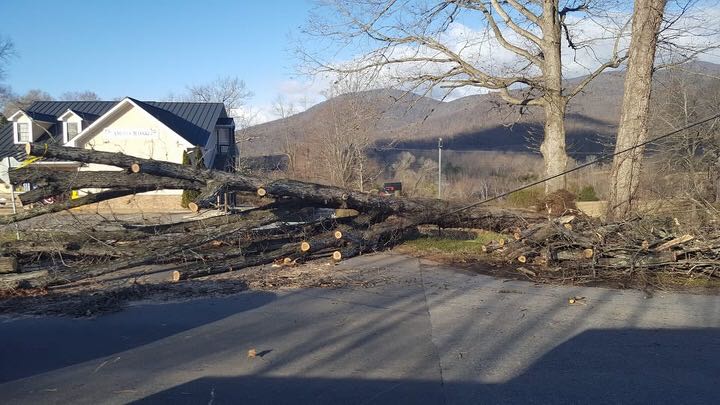
Photo courtesy of Sage Beam : A tree blocks Route 151 near Ashley’s Market Friday morning – March 2, 2018.
Numerous roads and highway were blocked across the area due to downed trees and powerlines.
Photo By Tommy Stafford – This large tree fell across the parking lot of the Nellysford Post Office landing very near Route 151. – Friday – March 2, 2018
The highest recorded wind gust we could find in our BRL WeatherNow network was 60 MPH at our Ski Barn location at the Route 664-151 intersection near Devils Backbone.
Our BRL-SkiBarn WeatherNow station recorded a 60 MPH wind gust on Friday afternoon – March 2, 2018. Click to enlarge.Photo By Tommy Stafford : This very large tree fell here in the front yard of BRL Friday morning – March 2, 2018 when winds gusted to 53 MPH.
Photo By Sage Beam :A large tree block Route 151 Friday morning near Ashley’s Market.
Photo By Sage Beam : Route 151 was also blocked in another location near Tanbark Drive.
Photo By Tommy Stafford : Crews with Becerra Lawncare cut up a large tree that fell here at BRL on Friday morning when winds gusted to 53 MPH.
Photo By Jessica Marshall : A broken traffic light swings in the high winds late Friday afternoon at the intersection of Route 151 and 250 just in side Albemarle County on Rockfish Gap Turnpike.
Photo Courtesy of Jesse Rutherford : In East Nelson on Peavine Mountain near Browning’s Cove a brush fire burned Friday evening.
In addition to many downed trees and powerlines area fire crews had spend much of the day Friday and the evening fighting brush fires being fanned by the continued high winds.
Tommy says we can look forward to a much quieter weekend with the winds finally relaxing throughout the afternoon Saturday.
Coming in like a lion with the March Issue, read about the masters plaster at Thomas Jefferson’s Poplar Forest, Yak Meets Wolf ( Wild Wolf Brewing Company ), Twin Warriors in Esmont, and more!
Click the digital magazine above to read online!
Grab a copy at a stand areawide (from Harrisonburg to Peaks Of Otter to Charlottesville and beyond) or read about it now, online. Enjoy!
Here’s to March and spring just around the corner!
Yvette, Tommy, Adam & Peyton
Click on the above image for the absolute latest updates from NWS.
EXPIRED – EXPIRED – EXPIRED
HIGH WIND WARNING
URGENT – WEATHER MESSAGE
National Weather Service Baltimore MD/Washington DC
812 PM EST Thu Mar 1 2018
Nelson-Albemarle-Greene-Madison-Orange-Culpeper-Spotsylvania-
Including the cities of Lovingston, Charlottesville,
Stanardsville, Madison, Orange, Gordonsville, Culpeper,
and Fredericksburg
812 PM EST Thu Mar 1 2018
…HIGH WIND WARNING REMAINS IN EFFECT FROM MIDNIGHT TONIGHT TO
MIDNIGHT EST FRIDAY NIGHT…
* TIMING…Midnight tonight to midnight Friday night.
* WINDS…Northwest 20 to 35 mph with gusts up to 60 mph. The
strongest winds will be Friday morning through Friday
afternoon.
* IMPACTS…Damaging winds will blow down trees and power lines.
Widespread power outages are expected. Travel will be
difficult, especially for high profile vehicles.
PRECAUTIONARY/PREPAREDNESS ACTIONS…
A High Wind Warning means a hazardous high wind event is expected
or occurring. Gusts of 58 mph or more can lead to property
damage.
URGENT – WEATHER MESSAGE
National Weather Service Baltimore MD/Washington DC
812 PM EST Thu Mar 1 2018
Washington-Extreme Western Allegany-Central and Eastern Allegany-
Augusta-Rockingham-Shenandoah-Frederick VA-Page-Warren-Clarke-
Western Highland-Eastern Highland-Northern Virginia Blue Ridge-
Central Virginia Blue Ridge-Hampshire-Morgan-Berkeley-Jefferson-
Hardy-Western Grant-Eastern Grant-Western Mineral-Eastern Mineral-
Western Pendleton-Eastern Pendleton-
Including the cities of Hagerstown, Frostburg, Cumberland,
Staunton, Waynesboro, Stuarts Draft, Harrisonburg, Strasburg,
Woodstock, Mount Jackson, New Market, Winchester, Luray,
Shenandoah, Stanley, Front Royal, Berryville, Hightown, Monterey,
Big Meadows, Wintergreen, Romney, Paw Paw, Martinsburg,
Charles Town, Shepherdstown, Moorefield, Bayard, Mount Storm,
Petersburg, Elk Garden, Antioch, Keyser, New Creek, Ridgeville,
Russelldale, Headsville, Fort Ashby, Riverton, Brandywine,
Franklin, Oak Flat, Ruddle, and Sugar Grove
812 PM EST Thu Mar 1 2018
…HIGH WIND WARNING NOW IN EFFECT UNTIL 6 AM EST SATURDAY…
* TIMING…This evening through Friday night.
* WINDS…Northwest 25 to 40 mph with gusts around 60 to 70 mph.
The strongest winds will likely occur Friday morning.
* IMPACTS…Damaging winds will blow down trees and power lines.
Widespread power outages are expected. Travel will be
difficult, especially for high profile vehicles.
PRECAUTIONARY/PREPAREDNESS ACTIONS…
A High Wind Warning means a hazardous high wind event is expected
or occurring. Sustained wind speeds of at least 40 mph or gusts
of 58 mph or more can lead to property damage.
URGENT – WEATHER MESSAGE
National Weather Service Blacksburg VA
605 PM EST Thu Mar 1 2018
…Damaging Winds Expected Tonight into Saturday morning…
.Very strong to damaging northwest winds will follow a passing
cold front this evening and then persist through Friday across
the entire area, though will linger into Saturday morning. Wind
gusts of 50 to 60 mph can be expected across much of the area
overnight through Friday, with even higher speeds possible along
the ridges.
Ashe-Alleghany NC-Surry-Stokes-Watauga-Wilkes-Yadkin-Tazewell-
Smyth-Bland-Giles-Wythe-Pulaski-Montgomery-Grayson-Carroll-Floyd-
Craig-Alleghany VA-Bath-Roanoke-Botetourt-Rockbridge-Patrick-
Franklin-Bedford-Amherst-Henry-
Including the cities of West Jefferson, Sparta, Dobson, Danbury,
Boone, Wilkesboro, Yadkinville, Tazewell, Marion, Bland,
Pearisburg, Wytheville, Radford, Pulaski, Blacksburg,
Independence, Whitetop, Troutdale, Volney, Galax, Floyd,
New Castle, Clifton Forge, Covington, Hot Springs, Roanoke,
Salem, Fincastle, Lexington, Buena Vista, Stuart, Rocky Mount,
Bedford, Amherst, and Martinsville
605 PM EST Thu Mar 1 2018
…HIGH WIND WARNING REMAINS IN EFFECT UNTIL 11 AM EST SATURDAY…
* Locations…Along and either side of the Blue Ridge in
Virginia and North Carolina.
* Hazards…Very strong to damaging northwest winds.
* Winds…Northwest 20 to 35 mph with gusts to 60 mph, or
stronger at higher elevations.
* Timing…Starting this evening continuing into Saturday
morning. Strongest winds late tonight through much of Friday.
* Impacts…Numerous downed trees and power outages likely.
Minor structural damage possible. Winds this strong can also
make travel difficult, especially for high profile vehicles.
PRECAUTIONARY/PREPAREDNESS ACTIONS…
A High Wind Warning means a hazardous high wind event is expected
or occurring. Sustained wind speeds of at least 40 mph or gusts
of 58 mph are likely to cause power outages…fallen trees…
property damage…and dangerous driving conditions for high
profile vehicles. Move unfastened items…such as garbage cans
and deck furniture…indoors.
HIGH WIND WATCH URGENT – WEATHER MESSAGE
National Weather Service Baltimore MD/Washington DC
252 PM EST Wed Feb 28 2018
District of Columbia-Frederick MD-Carroll-Northern Baltimore-
Southern Baltimore-Prince Georges-Anne Arundel-Charles-St. Marys-
Calvert-Northwest Montgomery-Central and Southeast Montgomery-
Northwest Howard-Central and Southeast Howard-Northwest Harford-
Southeast Harford-Nelson-Albemarle-Greene-Madison-Rappahannock-
Orange-Culpeper-Prince William/Manassas/Manassas Park-Fairfax-
Arlington/Falls Church/Alexandria-Stafford-Spotsylvania-
King George-Northern Fauquier-Southern Fauquier-Western Loudoun-
Eastern Loudoun-
Including the cities of Washington, Frederick, Ballenger Creek,
Eldersburg, Westminster, Reisterstown, Cockeysville, Baltimore,
Bowie, Suitland-Silver Hill, Clinton, College Park, Greenbelt,
Laurel, Camp Springs, Glen Burnie, Annapolis, Severn, South Gate,
Severna Park, Arnold, Odenton, St. Charles, Waldorf,
Lexington Park, California, Chesapeake Beach, Huntingtown,
Dunkirk, North Beach, Lusby, Prince Frederick, Germantown,
Damascus, Bethesda, Rockville, Gaithersburg, Silver Spring,
Lisbon, Columbia, Ellicott City, Jarrettsville, Aberdeen,
Lovingston, Charlottesville, Stanardsville, Madison, Orange,
Gordonsville, Culpeper, Dale City, Manassas, Woodbridge,
Lake Ridge, Montclair, Reston, Herndon, Annandale, Centreville,
Chantilly, McLean, Franconia, Arlington, Alexandria, Falmouth,
Fredericksburg, Dahlgren, Warrenton, Turnbull, Purcellville,
Leesburg, Ashburn, and Sterling
252 PM EST Wed Feb 28 2018
…HIGH WIND WATCH IN EFFECT FROM LATE THURSDAY NIGHT THROUGH
LATE FRIDAY NIGHT…
The National Weather Service in Baltimore MD/Washington has
issued a High Wind Watch, which is in effect from late Thursday
night through late Friday night.
* TIMING…Overnight Thursday through Friday night.
* WINDS…Northwest 25 to 40 mph with the potential for gusts
around 60 mph.
* IMPACTS…Damaging winds will blow down trees and power lines.
Widespread power outages are possible. Travel will be
difficult, especially for high profile vehicles.
PRECAUTIONARY/PREPAREDNESS ACTIONS…
A High Wind Watch means there is the potential for a hazardous
high wind event. Sustained winds of at least 40 mph, or gusts of
58 mph or stronger may occur. Continue to monitor the latest
forecasts.
URGENT – WEATHER MESSAGE
National Weather Service Baltimore MD/Washington DC
252 PM EST Wed Feb 28 2018
Washington-Extreme Western Allegany-Central and Eastern Allegany-
Augusta-Rockingham-Shenandoah-Frederick VA-Page-Warren-Clarke-
Western Highland-Eastern Highland-Northern Virginia Blue Ridge-
Central Virginia Blue Ridge-Hampshire-Morgan-Berkeley-Jefferson-
Hardy-Western Grant-Eastern Grant-Western Mineral-Eastern Mineral-
Western Pendleton-Eastern Pendleton-
Including the cities of Hagerstown, Frostburg, Cumberland,
Staunton, Waynesboro, Stuarts Draft, Harrisonburg, Strasburg,
Woodstock, Mount Jackson, New Market, Winchester, Luray,
Shenandoah, Stanley, Front Royal, Berryville, Hightown, Monterey,
Big Meadows, Wintergreen, Romney, Paw Paw, Martinsburg,
Charles Town, Shepherdstown, Moorefield, Bayard, Mount Storm,
Petersburg, Elk Garden, Antioch, Keyser, New Creek, Ridgeville,
Russelldale, Headsville, Fort Ashby, Riverton, Brandywine,
Franklin, Oak Flat, Ruddle, and Sugar Grove
252 PM EST Wed Feb 28 2018
…HIGH WIND WATCH IN EFFECT FROM THURSDAY EVENING THROUGH LATE
FRIDAY NIGHT…
The National Weather Service in Baltimore MD/Washington has
issued a High Wind Watch, which is in effect from Thursday
evening through late Friday night.
* TIMING…Thursday night through Friday night.
* WINDS…Northwest 25 to 40 mph with the potential for gusts
around 60 mph.
* IMPACTS…Damaging winds will blow down trees and power lines.
Widespread power outages are possible. Travel will be
difficult, especially for high profile vehicles.
PRECAUTIONARY/PREPAREDNESS ACTIONS…
A High Wind Watch means there is the potential for a hazardous
high wind event. Sustained winds of at least 40 mph, or gusts of
58 mph or stronger may occur. Continue to monitor the latest
forecasts.
URGENT – WEATHER MESSAGE
National Weather Service Blacksburg VA
1055 AM EST Wed Feb 28 2018
…Very Strong Wind Thursday night into Saturday morning…
.Winds will turn to the northwest and increase behind an intense
cold front Thursday night and will continue into Saturday
morning.
Ashe-Alleghany NC-Surry-Watauga-Wilkes-Yadkin-Tazewell-Smyth-
Bland-Giles-Wythe-Pulaski-Montgomery-Grayson-Carroll-Floyd-Craig-
Alleghany VA-Bath-Roanoke-Botetourt-Rockbridge-Patrick-Franklin-
Bedford-Amherst-Henry-
Including the cities of West Jefferson, Sparta, Dobson, Boone,
Wilkesboro, Yadkinville, Tazewell, Marion, Bland, Pearisburg,
Wytheville, Radford, Pulaski, Blacksburg, Independence, Whitetop,
Troutdale, Volney, Galax, Floyd, New Castle, Clifton Forge,
Covington, Hot Springs, Roanoke, Salem, Fincastle, Lexington,
Buena Vista, Stuart, Rocky Mount, Bedford, Amherst,
and Martinsville
1055 AM EST Wed Feb 28 2018
…HIGH WIND WATCH IN EFFECT FROM THURSDAY EVENING THROUGH
SATURDAY MORNING…
The National Weather Service in Blacksburg has issued a High Wind
Watch, which is in effect from Thursday evening through Saturday
morning.
* Locations…Mountains and foothills of southwest Virginia and
northwest North Carolina.
* Hazards…Very strong to damaging wind.
* Winds…Northwest 20 to 30 mph with gusts up to 60 mph.
* Timing…Starting Thursday night and continuing into Saturday
morning.
* Impacts…Numerous downed trees and power outages likely. Minor
structural damage possible.
PRECAUTIONARY/PREPAREDNESS ACTIONS…
A High Wind Watch means there is the potential for a hazardous
high wind event. Sustained winds of at least 40 mph…or gusts of
58 mph or stronger may occur. Continue to monitor the latest
forecasts.
The view early Tuesday morning as the sun rises above the Blue Ridge as seen from our BRL-SkiBarn webcam.
Roseland
Nelson County, Virginia
For the first time in several days the sun is shining brightly across the Centra Virginia Blue Ridge. Our BRL-SkiBarn webcam captured the beautiful image above early Tuesday morning.
Tommy says it won’t be long lived unfortunately. Rain renters the forecast again by Wednesday night.
Jarmans Gap Road
Crozet
Albemarle County, VirginiaPress release via Albemarle County Police:
On February 23, 2018, members of the Albemarle County Police Department responded to the 6700 block of Jarmans Gap Road, Crozet for a reported narcotics violation. Once on location officers seized 28 pounds of Marijuana, Methamphetamine, LSD, Powder and Crack Cocaine, and THC extracts to include oils and butter.
Scott Allen Melton, of Crozet, has been charged with five counts of Possession with the Intent to Distribute a Schedule I or II Narcotic, and Possession with the Intent Sell or Distribute Marijuana in excess of five pounds.
Melton is being held at the Albemarle Charlottesville Regional Jail.
Captain Darrell R. Byers
Blue Ridge District Commander – ACPD
Above is the email Yvette Stafford, Publisher of BRL, received late Thursday evening. This was after a request to provide information on a threat made earlier this week at Nelson County High School. We have opted to post the email in its entirety to be clear on what the officials say happened. You can click on the photo above to enlarge.
Lovingston
Nelson County, Virginia
For the past couple of days rumors have been swirling around about threats made at Nelson County High School. Apparently, it coincidentally happend at the same time a malfunction occurred with their fire alarm system this week.
“Our maintenance foreman was working on the fire alarm and inadvertently tripped it. An announcement was made that it was a false alarm and that students were to remain in place. The alarm did startle some students and give cause for concern though there was no emergency need to evacuate the building. We do regret that this happened especially after such recent tragic events.” Shannon T. Irvin, Assistant Superintendent for Administration
To set the record straight after countless emails, phone calls, and Facebook messages from parents to BRL, we reached out to school officials and received the email above at the top of this story.
Above a sequenced view as Tuesday morning begins on our BRL-SkiBarn webcam. February 20, 2018.
Beech Grove / Roseland
Nelson County, Virginia
About a month ago we put our first BRL Webcam online. It’s at the intersection of Route 664 & 151 in Nelson County at the foot of Wintergreen Resort. Our partnership with The Ski Barn started last summer when we put up a weather station there to get live weather conditions.
Above, live conditions from our BRL-SkiBarn Weather Now station. Click on the image above to get even more details from that station.
A month after putting up the webcam we’ve been getting some really great images! Light from beautiful sunrise behind hitting the peaks of the Blue Ridge and breathtaking sunsets.
Above a sequential view for around daybreak Tuesday as the sun hits Three Ridges along the Blue Ridge Parkway to the west. Click on that image above to see the latest view from our BRL-SkiBarn webcam. You can also watch neat time lapse video loops from the past month there too!
Above, larger individual views of the sun as it’s coming up on the Blue Ridge Tuesday morning – February 20, 2018.
Tuesday will be a very mild day with temps in the 70s! I talk more about that and an even warmer Wednesday in my audio weather update below.
A nice surprise for folks Sunday night as Wintergreen Resort held a special fireworks celebration for the President’s Day weekend to recognize and celebrate Olympians. Brilliant colors lit up the sky over the resort and down into the Rockfish Valley.
BRL Mountain Photographer Paul Purpura, who’s been shooting beautiful mountain pics for us for over a dozen years now (Whoa! – That long already??) grabbed lots more photos from the Sunday night fireworks display.
Check them out in our gallery below!
The next planned fireworks display will be the big one that’s held each summer to celebrate July 4th.
Precipitation has either ended or changed over to rain. No
additional accumulating snowfall is expected. However, snow
covered surfaces will remain slippery through the night.
Original post:
URGENT – WINTER WEATHER MESSAGE
National Weather Service Blacksburg VA
1139 PM EST Fri Feb 16 2018
…Wintry Mix Expected Saturday Afternoon And Evening…
.Cold air will move back into the area from the north on
Saturday. This colder air will clash with a warm front that will
be bringing moisture back into the area from the south. A mixed
bag of precipitation is expected for the central Appalachians
with accumulating snow and sleet along and north of Interstate
64. Freezing rain will occur farther southwest along the spine of
the Blue Ridge.
Giles-Montgomery-Floyd-Craig-Alleghany VA-Bath-Roanoke-Botetourt-
Rockbridge-Patrick-Franklin-Bedford-Amherst-Monroe-
Eastern Greenbrier-Western Greenbrier-
Including the cities of Pearisburg, Blacksburg, Floyd,
New Castle, Clifton Forge, Covington, Hot Springs, Roanoke,
Salem, Fincastle, Lexington, Buena Vista, Stuart, Rocky Mount,
Bedford, Amherst, Union, Lewisburg, White Sulphur Springs,
Quinwood, Duo, and Rainelle
1139 PM EST Fri Feb 16 2018
…WINTER WEATHER ADVISORY REMAINS IN EFFECT FROM 10 AM SATURDAY
TO MIDNIGHT EST SATURDAY NIGHT…
* WHAT…Mixed precipitation expected with primarily snow and
sleet from Interstate 64 northward and freezing rain and rain
to the south. Temperatures will be near freezing.
* WHERE…Total wet snow accumulations of 2 to 4 inches can be
expected along and north of Interstate 64, with less snow and
more freezing rain to the south toward the Roanoke and New
River Valleys. Freezing rain, with 1 to 2 tenths of an inch of
ice accumulation, can be expected on elevated surfaces along
the spine of the Blue Ridge from Roanoke to Stuart, including
the eastern New River Valley and foothill counties west of
Lynchburg and Martinsville. Greatest ice accumulations will be
in the trees along the Blue Ridge Parkway.
* WHEN…From 10 AM Saturday to midnight EST Saturday night.
* ADDITIONAL DETAILS…Snow and sleet may result in difficult
travel conditions. Freezing rain may result in downed tree
limbs and power outages. Since ground temperatures are warm,
the primary threat from icing will be on elevated surfaces.
PRECAUTIONARY/PREPAREDNESS ACTIONS…
A Winter Weather Advisory means that periods of snow, sleet or
freezing rain will cause travel difficulties. Be prepared for
slippery roads and limited visibilities, and use caution while
driving. The latest road conditions for the state you are calling
from can be obtained by calling 5 1 1.
URGENT – WINTER WEATHER MESSAGE
National Weather Service Baltimore MD/Washington DC
912 PM EST Fri Feb 16 2018
Augusta-Rockingham-Shenandoah-Page-Warren-Rappahannock-
Northern Fauquier-Eastern Highland-Northern Virginia Blue Ridge-
Central Virginia Blue Ridge-Hardy-Eastern Grant-Eastern Pendleton-
912 PM EST Fri Feb 16 2018
…WINTER WEATHER ADVISORY IN EFFECT FROM NOON SATURDAY TO
MIDNIGHT EST SATURDAY NIGHT…
* WHAT…Snow…sleet and freezing rain. Total snow and sleet
accumulations of 1 to 3 inches and a light glaze of ice
accumulations less than a tenth of an inch are expected.
* WHERE…Central Shenandoah Valley of Virginia, portions of the
Potomac Highlands in Virginia and West Virginia. Portions of
northern Virginia as well as the Blue Ridge Mountains.
* WHEN…From noon Saturday to midnight EST Saturday night.
* ADDITIONAL DETAILS…Snow and sleet will begin between noon and
3 pm Saturday. Precipitation may mix with freezing rain before
ending Saturday evening. Roads may become snow covered and
slippery at times, especially in the higher elevations.
Visibility below one mile is expected at times.
PRECAUTIONARY/PREPAREDNESS ACTIONS…
A Winter Weather Advisory means that periods of snow, sleet or
freezing rain will cause travel difficulties. Be prepared for
slippery roads and limited visibilities, and use caution while
driving. The latest road conditions for the state you are calling
from can be obtained by calling 5 1 1.