Home Blog Page 106

VDOT Responds To Winter Weather Across Region

0

DRIVE CAREFULLY OVERNIGHT MONDAY AND EARLY TUESDAY (4:15 PM – 3.12.18)

Expect potential refreeze, check 511 Virginia for road conditions


CULPEPER — Winter weather is expected to move out of the Central Virginia region Monday evening but the Virginia Department of Transportation’s Culpeper District cautions motorists to drive for the conditions as temperatures drop below freezing overnight.


As of 4 p.m., roads in Albemarle, Culpeper, Fauquier, Fluvanna, Greene, Louisa, Madison, Orange and Rappahannock counties are reported to be clear. Motorists may encounter some slushy conditions on Interstate 64 and Route 250 near Afton Mountain and Route 33 across Swift Run Gap in Greene County.


Below-freezing temperatures overnight Monday could cause wet surfaces to refreeze. Some VDOT operators will remain on duty overnight in Albemarle County, including I-64, to treat any slick spots with sand and salt to aid melting and improve traction.


Drivers planning to travel Monday evening and early Tuesday morning, especially south and west of Charlottesville, should check road conditions using VDOT’s free 511 tools. Motorists are encouraged to plan for extra travel time and reduce speed.


Additional information about winter-weather preparations and response can be found at www.virginiadot.org/travel/snow.asp. Local updates are also posted to Twitter.com/VaDOTCulp and on the district’s snow information webpage.


ROAD CONDITIONS IMPROVE FOLLOWING MONDAY SNOW STORM IN SOUTHERN SHENANDOAH VALLEY (4:08 PM – 3.12.18)

STAUNTON – (4 p.m.) Light snow continues to fall in the southern portion of the Shenandoah Valley in the late afternoon hours of Monday, March 12. A snowstorm that began early this morning is departing the area, leaving the northern part of the Valley untouched with snow and the southern part with several inches on the ground.

Road conditions are generally clear on all interstate and primary roads within the Virginia Department of Transportation Staunton District. Secondary roads range from minor to moderate in Rockingham, Augusta, Rockbridge, Alleghany, Bath and Highland counties. Little or no snow fell in the areas north of Harrisonburg.

Crews will be out tonight in Augusta, Rockbridge, Highland, Bath and Alleghany counties. The remainder of the district will have crews on call throughout the night. All VDOT crews will treat roads as conditions warrant.

Motorists should be alert for refreezing conditions and use extreme caution if they travel during the nighttime and early morning hours. Bridges, overpasses and any surface with air underneath it will freeze first. Temperatures are forecasted to be well below freezing tonight throughout the region.

For winter weather road conditions go to http://www.511Virginia.org, look at the orange bar on the top of the page and click on “Text Views” and then click on “Road Condition Table”. Look at the pull down box that lists all jurisdictions. In this box individual counties can be chosen to view.

On the go? Then visit VDOT’s Free Virginia 511 Tools to get your 511 app for android or iOS. Traffic alerts and traveler information can be obtained by dialing 511.

The VDOT Customer Service Center can be accessed through its mobile friendly website at https://my.vdot.virginia.gov/. Agents are on site 24/7 every day of the year to assist the public. People can also call the VDOT Customer Service Center at 800-FOR- ROAD (800-367-7623).

The Staunton District Snow Page is on the VDOT website under Travel Center Snow Emergency Pages. The Staunton District Twitter feed is at @VaDOTStaunton.

The Staunton District Twitter feed is at @VaDOTStaunton. VDOT can be followed on Facebook, Flickr, Twitter and YouTube. RSS feeds are also available for statewide information. The VDOT Web page is located at http://www.VirginiaDOT.org.

The VDOT Staunton District serves Frederick, Shenandoah, Clarke, Warren, Page, Rockingham, Augusta, Highland, Rockbridge, Alleghany and Bath counties.

Road condition definitions:
Severe – drifting or partially blocked road. Snow tires or chains are necessary.
Moderate – snow or ice on major portions of the roadway. Snow tires or chains are advisable.
Minor – bare pavement except for isolated spots of snow, ice or slush. Driving with caution is recommended.

EFFECTS OF WINTER STORM TO CONTINUE INTO TUESDAY (3:45 PM – 3.12.18)
Motorists should anticipate possible icy conditions

LYNCHBURG – A mixed bag of precipitation –rain, snow, light sleet and a combination of all three – has fallen across the Lynchburg District of the Virginia Department of Transportation (VDOT) today and its effects will linger into Tuesday.

While snow is expected to end during the evening hours Monday, motorists should anticipate icy conditions, especially on bridges, overpasses and ramps through midmorning Tuesday.

Up to several inches of snow have fallen on roadways as of early afternoon and temperatures have been hovering near freezing. Temperatures are expected to rise and most precipitation turn to rain before ending in the early evening.

Motorists may monitor road conditions using VDOT’s free 511 tools. Additional information about winter-weather preparations and response may be found on VDOT’s website at www.virginiadot.org/travel/snow.asp. Local updates will be posted to VDOT’s Lynchburg District Twitter account.

The Lynchburg District includes the counties of Amherst, Appomattox, Buckingham, Campbell, Charlotte, Cumberland, Halifax, Nelson, Pittsylvania and Prince Edward.

WINTER STORM WILL AFFECT CENTRAL VA. TRAVEL ON MONDAY : 5:30 AM 3.12.18
VDOT advises drivers to monitor local weather; use 511 Virginia for road conditions

CULPEPER — Winter weather has overspread southwest Virginia and precipitation is forecast to begin around daybreak in Central Virginia. The Virginia Department of Transportation’s Culpeper District is ready for a storm that will bring a wintry mix of rain, sleet and snow to the area through early Monday evening.

VDOT crews are on duty and prepared for the storm. Once snow begins to fall, VDOT operators will treat roads with sand and salt to improve traction and aid melting. They will begin plowing if snow accumulates to a depth of about two inches on the road surface. Crews will first focus on interstates and primary highways before shifting to secondary routes.

Since the weather may vary widely by location, drivers are advised to use VDOT’s free 511 tools to know road conditions along their routes and at their destination. Motorists are encouraged to monitor local forecasts and drive for the conditions by reducing speed and increasing following distance.

Additional information about winter-weather preparations and response can be found at www.virginiadot.org/travel/snow.asp. Local updates are also posted to Twitter.com/VaDOTCulp and on the district’s snow information webpage.

VDOT’s Culpeper District includes the counties of Albemarle, Culpeper, Fauquier, Fluvanna, Greene, Louisa, Madison, Orange and Rappahannock.

WINTER WEATHER FORECAST BEGINS TO COME TOGETHER
Motorists should anticipate difficult driving conditions

LYNCHBURG – Rain, snow and a mix of the two will fall across much of the commonwealth beginning today (Sunday, March 11) and throughout tomorrow (Monday, March 12).

In the Lynchburg District of the Virginia Department of Transportation (VDOT), rain is likely late tonight before mixing with snow early tomorrow before changing to all snow and ending Monday evening. However, forecasts should be monitored carefully as slight changes in direction or temperatures can make a difference in outcomes.

Lynchburg District crews will report during the overnight. Plowing, with efforts concentrating on primary routes (those numbered 1-599) will begin once appropriate snow accumulations have occurred.

While snow is expected to end during the evening hours Monday, motorists should anticipate icy conditions, especially on bridges, overpasses and ramps through Tuesday midday.

Motorists should get ready as well. First, monitor road conditions using VDOT’s free 511 tools. Additional information about winter-weather preparations and response can be found on VDOT’s website at www.virginiadot.org/travel/snow.asp. Local updates will be posted to VDOT’s Lynchburg District Twitter account.

The Lynchburg District includes the counties of Amherst, Appomattox, Buckingham, Campbell, Charlotte, Cumberland, Halifax, Nelson, Pittsylvania and Prince Edward.

WINTER WEATHER COMING TO ROADWAYS IN SHENANDOAH VALLEY

STAUNTON – (11:30 a.m.) A winter weather system is forecasted to bring rain changing to snow in the Shenandoah Valley. The rain will begin late on Sunday, March 11 and change over to all snow overnight. Heavier snow is forecasted for the southern end of the Staunton District, which covers Frederick, Shenandoah, Clarke, Warren, Page, Rockingham, Augusta, Highland, Rockbridge, Alleghany and Bath counties. Higher elevations are expected to have more snow than the Valley floor but motorists should be prepared for winter weather driving conditions throughout the region.

Because the storm is expected to begin as rain the Virginia Department of Transportation Staunton District will not pretreat roads for this winter weather event. VDOT will have crews out beginning Sunday night and into the day on Monday. Crews will plow and treat roads as the weather moves into the area.

For this storm drivers should expect:
Higher snow amounts the farther south you drive beginning in the pre-dawn hours of Monday.
Increasing snow amounts and more icing conditions in higher elevations.
Icing conditions on bridges and overpasses.
Refreezing and black ice overnight Monday into Tuesday morning.
Travelers should always buckle their seat belts and drivers should always be alert and use extreme cation.

Travelers are asked to monitor local weather forecasts and to avoid driving if possible during the snow storm.

Road conditions and traffic cameras can be found on the VDOT 511 website at http://www.511Virginia.org, Roads with snow conditions will be marked minor, moderate, severe or closed.

Road condition definitions:
Closed – Road is closed to all traffic.
Severe – drifting or partially blocked road.
Moderate – snow or ice on major portions of the roadway.
Minor – bare pavement except for isolated spots of snow, ice or slush. Driving with caution is recommended.

For a text listing of winter weather road conditions go to http://www.511Virginia.org, look at the orange bar on the top of the page and click on “Text Views” and then click on “Road Condition Table”. Look at the pull down box that lists all jurisdictions. In this box individual counties can be chosen to view.

On the go? Then visit VDOT’s Free Virginia 511 Tools to get your 511 app for android or iOS. Traffic alerts and traveler information can be obtained by dialing 511.

The VDOT Customer Service Center can be accessed through its mobile friendly website at https://my.vdot.virginia.gov/. Agents are on site 24/7 every day of the year to assist the public. People can also call the VDOT Customer Service Center at 800-FOR- ROAD (800-367-7623).

The Staunton District Snow Page is on the VDOT website under Travel Center Snow Emergency Pages. The Staunton District Twitter feed is at @VaDOTStaunton.

VDOT statewide Twitter messages can be found at @VaDOT. The nine districts can be found at:Hampton Roads @VaDOTHR; Richmond @VaDOTRVA; Northern Virginia @VaDOTNOVA; Fredericksburg @VaDOTFred; Culpeper @VaDOTCulp; Lynchburg @VaDOTLynchburg; Bristol @VaDOTBristol; Salem @VaDOTSalem; Staunton @VaDOTStaunton.

VDOT PREPARES FOR LATE-WINTER STORM
Monitor local weather; use 511 Virginia for road conditions

CULPEPER — The Virginia Department of Transportation’s Culpeper District is preparing for a late-winter storm that is forecast to bring rain and snow to Central Virginia late Sunday through Monday evening.

Crews are preparing equipment and will report to work at midnight tonight. Once snow begins to fall, VDOT operators will treat roads with sand and salt to improve traction and aid melting. They will begin plowing if snow accumulates to a depth of about two inches on the road surface. Crews will first focus on interstates and primary highways before shifting to secondary routes.

Since the weather may vary widely by location, drivers are advised to use VDOT’s free 511 tools to know road conditions along their routes and at their destination.

Motorists are encouraged to monitor local forecasts and drive for the conditions by reducing speed and increasing following distance.

Additional information about winter-weather preparations and response can be found at www.virginiadot.org/travel/snow.asp. Local updates are also posted to Twitter.com/VaDOTCulp and on the district’s snow information webpage.

VDOT’s Culpeper District includes the counties of Albemarle, Culpeper, Fauquier, Fluvanna, Greene, Louisa, Madison, Orange and Rappahannock.

Winter Storm Warnings / Advisories : CANCELED OR EXPIRED FOR MOST AREAS

0
Click on image above for the absolute latest updates from NWS.

Some of the previously included area in the Winter Storm Warning have been downgraded to advisories (including Nelson) – click here for those details and update as well as latest warnings.

WINTER STORM WARNING
URGENT – WINTER WEATHER MESSAGE
National Weather Service Baltimore MD/Washington DC
754 PM EDT Sun Mar 11 2018

Augusta-Nelson-Western Highland-Eastern Highland-
Central Virginia Blue Ridge-
754 PM EDT Sun Mar 11 2018

…WINTER STORM WARNING NOW IN EFFECT FROM 1 AM TO 2 PM EDT
MONDAY…

* WHAT…Significant snow expected. Total snow accumulations 1
to 3 inches in the valleys and 3 to 6 inches along the ridges
above 2000 feet.

* WHERE…Augusta, Nelson, Highland, and central Virginia Blue
Ridge.

* WHEN…From 1 AM to 2 PM EDT Monday.

* ADDITIONAL DETAILS…Plan on difficult travel conditions,
including during the morning commute Monday. Slippery
conditions may continue into the evening commute Monday along
the ridges. Be prepared for significant reductions in
visibility at times.

PRECAUTIONARY/PREPAREDNESS ACTIONS…

A Winter Storm Warning for snow means severe winter weather
conditions will make travel very hazardous or impossible. If you
must travel, keep an extra flashlight, food and water in your
vehicle in case of an emergency. The latest road conditions for
the state you are calling from can be obtained by calling 5 1 1.

URGENT – WINTER WEATHER MESSAGE
National Weather Service Blacksburg VA
338 PM EDT Sun Mar 11 2018

A complex storm system will develop over the southeastern US
today then begin moving northeast tonight and Monday, eventually
toward the North Carolina coast later in the day Monday. While
there remain some uncertainties, confidence is increasing that
this storm has the potential to bring moderate to heavy snow to
much of the forecast area, especially near and west of the Blue
Ridge, Sunday night through Monday morning.

Ashe-Watauga-Bland-Giles-Wythe-Pulaski-Montgomery-Grayson-Carroll-
Floyd-Craig-Alleghany VA-Bath-Roanoke-Botetourt-Rockbridge-
Franklin-Bedford-Amherst-Mercer-Summers-Monroe-Eastern Greenbrier-
Western Greenbrier-
Including the cities of West Jefferson, Boone, Bland, Pearisburg,
Wytheville, Radford, Pulaski, Blacksburg, Independence, Whitetop,
Troutdale, Volney, Galax, Floyd, New Castle, Clifton Forge,
Covington, Hot Springs, Roanoke, Salem, Fincastle, Lexington,
Buena Vista, Rocky Mount, Bedford, Amherst, Bluefield, Hinton,
Hix, Union, Lewisburg, White Sulphur Springs, Quinwood, Duo,
and Rainelle
338 PM EDT Sun Mar 11 2018

…WINTER STORM WARNING REMAINS IN EFFECT FROM MIDNIGHT TONIGHT
TO MIDNIGHT EDT MONDAY NIGHT…

* WHAT…Heavy wet snow expected. Snow is expected to begin after
midnight and fall heaviest in the morning hours. Total snow
accumulations of 3 to 5 inches, with localized amounts up to 8
inches, are expected.

* WHERE…Portions of central, south central, southwest and west
central Virginia, northwest North Carolina and southeast West
Virginia.

* WHEN…From midnight Sunday to midnight EDT Monday night.

* ADDITIONAL DETAILS…Plan on difficult travel conditions,
including during the morning commute on Monday. Be prepared
for significant reductions in visibility at times.

PRECAUTIONARY/PREPAREDNESS ACTIONS…

A Winter Storm Warning means significant amounts of snow, sleet
and ice will make travel very hazardous or impossible. The latest
road conditions for the state you are calling from can be
obtained by calling 5 1 1.

URGENT – WINTER WEATHER MESSAGE
National Weather Service Baltimore MD/Washington DC
754 PM EDT Sun Mar 11 2018

Rockingham-Shenandoah-Page-Albemarle-Greene-Madison-
Northern Virginia Blue Ridge-Hardy-Western Grant-Eastern Grant-
Western Pendleton-Eastern Pendleton-
754 PM EDT Sun Mar 11 2018

…WINTER WEATHER ADVISORY NOW IN EFFECT FROM 4 AM TO NOON EDT
MONDAY…

* WHAT…Snow expected. Total snow accumulations 1 to 2 inches
in the valleys and 2 to 4 inches along the ridges above 2000
feet.

* WHERE…Portions of central Virginia, the Shenandoah Valley
and the Potomac Highlands of eastern West Virginia.

* WHEN…From 4 AM to noon EDT Monday.

* ADDITIONAL DETAILS…Plan on snow covered and slippery roads,
especially during the morning commute for Monday. Be prepared
for reductions in visibility at times.

PRECAUTIONARY/PREPAREDNESS ACTIONS…

A Winter Weather Advisory for snow means periods of snow will
cause primarily travel difficulties. Be prepared for snow covered
roads and limited visibilities, and use caution while driving.
The latest road conditions for the state you are calling from can
be obtained by calling 5 1 1.

URGENT – WINTER WEATHER MESSAGE
National Weather Service Blacksburg VA
338 PM EDT Sun Mar 11 2018

A complex storm system will develop over the southeastern US
today then begin moving northeast tonight and Monday, eventually
toward the North Carolina coast later in the day Monday. While
there remain some uncertainties, confidence is increasing that
this storm has the potential to bring moderate to heavy snow to
much of the forecast area, especially near and west of the Blue
Ridge, Sunday night through Monday morning.

Surry-Stokes-Rockingham-Caswell-Wilkes-Tazewell-Smyth-Patrick-
Henry-Pittsylvania-Campbell-Appomattox-Buckingham-Halifax-
Charlotte-
Including the cities of Dobson, Danbury, Eden, Yanceyville,
Wilkesboro, Tazewell, Marion, Stuart, Martinsville, Danville,
Lynchburg, Appomattox, South Boston, and Keysville
338 PM EDT Sun Mar 11 2018

…WINTER WEATHER ADVISORY REMAINS IN EFFECT FROM MIDNIGHT
TONIGHT TO MIDNIGHT EDT MONDAY NIGHT…

* WHAT…Snow expected. Snow may mix with sleet at times in the
upper NC Piedmont. Total snow accumulations of 1 to 3 inches,
with localized amounts up to 5 inches, are expected.

* WHERE…Portions of central, south central and southwest
Virginia and north central and northwest North Carolina.

* WHEN…From midnight tonight to midnight EDT Monday night.

* ADDITIONAL DETAILS…Plan on slippery road conditions. The
Monday morning commute will be significantly impacted. Be
prepared for reduced visibilities at times.

PRECAUTIONARY/PREPAREDNESS ACTIONS…

A Winter Weather Advisory for snow means periods of snow will
cause primarily travel difficulties. Be prepared for snow covered
roads and limited visibilities, and use caution while driving.
The latest road conditions for the state you are calling from can
be obtained by calling 5 1 1.

WINTER STORM WATCH : (Replaced By WINTER STORM WARNING)

0
Be sure to click on image above for the absolute latest updates from NWS.

This watch has now been upgraded to a warning. Click for details.

WINTER STORM WATCH
URGENT – WINTER WEATHER MESSAGE
National Weather Service Baltimore MD/Washington DC
311 PM EST Sat Mar 10 2018

Augusta-Nelson-Western Highland-Eastern Highland-
Central Virginia Blue Ridge-
311 PM EST Sat Mar 10 2018

…WINTER STORM WATCH IN EFFECT FROM SUNDAY EVENING THROUGH
MONDAY MORNING…

* WHAT…Significant snow possible with the potential for around 5
inches of accumulation.

* WHERE…Augusta, Nelson, Highland, and Central Virginia Blue
Ridge.

* WHEN…From late Sunday evening through Monday morning.

* ADDITIONAL DETAILS…Plan on difficult travel conditions due to
snow covered and slippery roads, including during the morning
commute on Monday. Significant reductions in visibility are
possible.

PRECAUTIONARY/PREPAREDNESS ACTIONS…

A Winter Storm Watch means there is potential for significant
snow accumulations that may impact travel. Continue to monitor
the latest forecasts.

URGENT – WINTER WEATHER MESSAGE
National Weather Service Blacksburg VA
327 PM EST Sat Mar 10 2018

A complex storm system will develop over the southeastern US on
Sunday, before moving toward the North Carolina coast early
Monday. This may bring moderate to heavy snow to the region,
especially west of the Blue Ridge, Sunday night through Monday
morning.

Alleghany VA-Bath-Botetourt-Rockbridge-Patrick-Franklin-Bedford-
Amherst-Eastern Greenbrier-Western Greenbrier-
Including the cities of Clifton Forge, Covington, Hot Springs,
Fincastle, Lexington, Buena Vista, Stuart, Rocky Mount, Bedford,
Amherst, Lewisburg, White Sulphur Springs, Quinwood, Duo,
and Rainelle
327 PM EST Sat Mar 10 2018

…WINTER STORM WATCH IN EFFECT FROM SUNDAY EVENING THROUGH
MONDAY AFTERNOON…

* WHAT…Heavy snow possible. Total snow accumulations of 2 to 4
inches, with localized higher amounts along ridgetop.

* WHERE…Portions of central, south central, southwest and west
central Virginia and southeast West Virginia.

* WHEN…From Sunday evening through Monday afternoon.

* ADDITIONAL DETAILS…Plan on difficult travel conditions,
including during the morning commute on Monday. Significant
reductions in visibility are possible.

PRECAUTIONARY/PREPAREDNESS ACTIONS…

A Winter Storm Watch means there is potential for significant
snow, sleet or ice accumulations that may impact travel. Continue
to monitor the latest forecasts.

Spring Forward This Weekend Saturday Night Before Bed : Daylight Saving Time Begins 2AM Sunday

0
Daylight Saving Time begins at 2 AM Sunday morning, so be sure to set your clock ahead 1 hour at bedtime Saturday night.
Daylight Saving Time begins at 2 AM this Sunday morning, so be sure to set your clock ahead 1 hour at bedtime Saturday night.

Central Virginia Blue Ridge

With a warmer day here and there thoughts are turning to longer days. Daylight Saving Time begins this Sunday – March 11th at 2AM. But for those of us that don’t party until that hour, your best bet is to move your clock ahead one hour before turning in on Saturday night. Then you’re all taken care of until Sunday – Nov 4, 2018 when we go back to standard time.

Until then, enjoy those longer and warmer days to come!

Nelson : Piney River : Construction Of Latest Dollar General Underway

1
©2018 Blue Ridge Life Magazine : A Nelson County Building Permit sign marks the location where a new Dollar General is under construction in Piney River of Southern Nelson County. Tuesday – March 6, 2018.

Piney River
Nelson County, Virginia

By Tommy Stafford

The latest Dollar General store in Nelson County is now under construction in Piney River of Southern Nelson County. It’s expected to open later this year.

“At this time, a grand opening is slated for late summer 2018, but understand that construction progress may alter this date,” Angela Petkovic from Dollar General’s Corporate Headquarters in Goodlettsville, Tennessee.

The construction area is at the intersection of Route 778 (Lowesville Road) and Route 151 in Piney River very near the old Raines TV building shown in the background.

Once completed the Piney River Dollar General joins the most recent one in Nelson that opened last year in Nellysford.

“When choosing store locations, meeting customers’ needs is Dollar General’s top priority. The company looks for places where we can offer customers an easy and convenient shopping choice. We know convenience is a major factor in our customers’ shopping decisions as we generally serve customers within a three to five mile radius, or 10 minute drive. We also take demographic trends, competitive factors, traffic patterns and community concerns into consideration.

The store will employ approximately 6-10 employees, depending on the individual needs of the store. Anyone interested in joining one of America’s fastest-growing retailers may apply for available positions online at www.dollargeneral.com/careers, Ms. Petkovic continued.

We’ll update more as progress continues with the construction.

News Alert : ACP Tree Cutting Begins Near Fenton Inn And Wintergreen Resort Entrance (Video)

1
©2018 Blue Ridge LIfe Magazine : Early Tuesday morning – March 6, 2018 – Crews were seen assembling to begin cutting trees near the entrance to Wintergreen Resort and property adjoining The Fenton Inn B & B on Route 664 just below the Blue Ridge Parkway.

Beech Grove
Near Wintergreen
Nelson County, Virginia

Passing motorists tell BRL a heavier than normal Virginia State Police presence was observed in the general area of Wintergreen Resort and The Fenton Inn’s entrance early Tuesday morning. Over the past several days crews marked trees that had been approved for removal as part of the Atlantic Coast Pipeline Construction.

This morning WPOA’s Executive Director, Jay Roberts released the following statement:

“ACP contractors arrived this morning to begin cutting trees on WPOA property. The Wintergreen Property Owners Association (WPOA), while opposed to the location of the Atlantic Coast Pipeline, understands and abides by the legal process that has led to the commencement of tree removal on WPOA property. While disappointed, the beginning of construction only increases our resolve to hold Dominion accountable for the financial and non-financial implications placed on our community by the presence of the pipeline. WPOA is committed to the best possible outcome for our community; one that provides fair treatment and security for our owners, employees and guests.

WPOA remains committed to holding Dominion accountable for the taking of our property and the burden this project places on our community going forward.”


Video uploaded by Richard Averitt of Nellysford and shared from his Facebook post.

Click on image above for more from FOW.

More updates as we know.

Nelson : Schuyler : Groundbreaking For Earl’s Meadow Held This Past Weekend

0
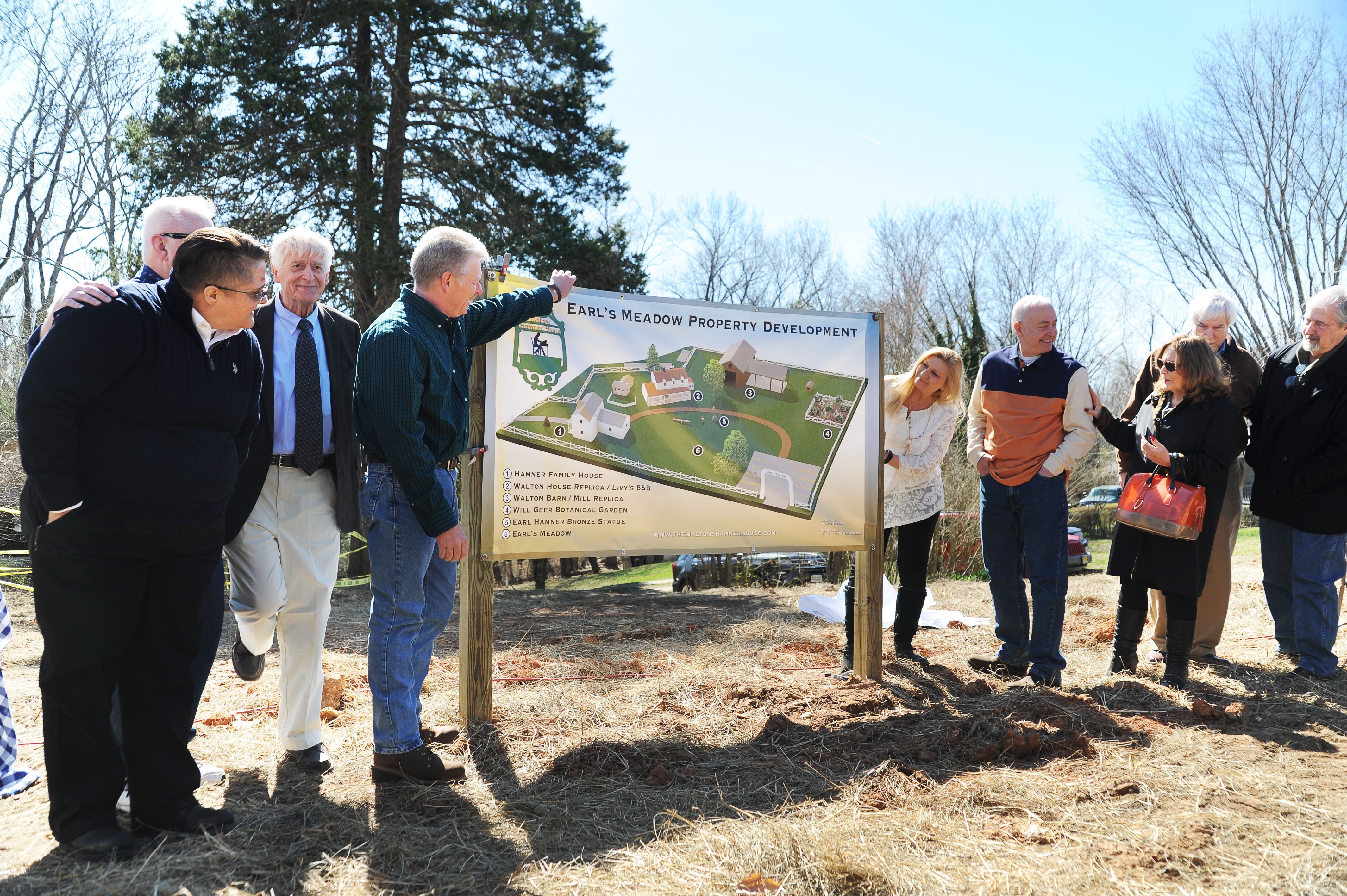
©2018 Blue Ridge Life Magazine : Photos By BRL Mountain Photographer Paul Purpura : Ray Castro (L-organizer and co-founder of Earl’s Meadow) along with relatives and dignitaries makes the ground breaking of Earl’s Meadow official this past Sunday – March 4, 2018 in Schuyler, Virginia.

Schuyler
Nelson County, Virginia

By Tommy Stafford

In a move to keep the memory and legacy of Earl Hamner alive, the official groundbreaking of Earl’s Meadow took place this past Sunday in Schuyler. That’s the birthplace of Earl Hamner, Jr., the creator of the highly popular 70’s CBS television series, The Waltons. The show was based on Hamner’s childhood experiences growing up in Schuyler. Earl also wrote many articles and poems in our magazine when we first started back in the mid 2000’s. He died two years ago this month in March of 2016 at the age of 92.

“We expect the replica to be completed by Fall 2018 and Earl’s Meadow to be completed in 2019.” Ray Castro tells us. He and business partner Carol Johnson are developing the project. They bought the original Hamner family home last year and have turned it into a museum.

Plans for all of Earl’s Meadows were unveiled at the groundbreaking. Sunday – March 4, 2018.
A closer look at the different phases of Earl’s Meadows.

Castro and Johnson purchased the property known as the Giannini house nearby to the old Hamner home. They determined the house was in such bad shape that it was eventually leveled and plans for Earl’s Meadow began.

You can learn more about the plans surrounding Earl’s Meadow and details on another reunion of The Walton’s stars planned this summer in June by heading over to The Waltons Hamner House on Facebook.

Nelson : Beech Grove : Refrigeration Truck Overturns Blocking Route 664

0
Photo Courtesy of John Howard : This refrigeration truck overturned just after noon Sunday on Route 664 in Beech Grove.

Beech Grove
Nelson County, Virginia

It was a slow go for folks driving along Route 664 in Beech Grove just after noon Sunday. A refrigeration truck overturned near Cub Creek Road completely blocking one lane and slowing traffic down until the truck could be removed.

Photo courtesy of Heidi Crandall : Another view of the overturned truck Sunday afternoon on Route 664 in Beech Grove. March 4, 2018.

It’s not believed anyone was seriously hurt. Passing motorists saw the driver out walking around and talking to emergency crews.

The accident was quickly cleared up and the road reopened to normal traffic.

Increased Fire Danger Sunday Afternoon and Evening (EXPIRED)

0
For the absolute latest updates, click on the image above from NWS.

Elevated fire weather conditions this afternoon
Special Weather Statement
National Weather Service Baltimore MD/Washington DC
1138 AM EST Sun Mar 4 2018

Augusta-Rockingham-Shenandoah-Frederick VA-Page-Warren-Clarke-
Nelson-Albemarle-Greene-Madison-Rappahannock-Orange-Culpeper-
Northern Virginia Blue Ridge-Central Virginia Blue Ridge-
Including the cities of Staunton, Waynesboro, Stuarts Draft,
Harrisonburg, Strasburg, Woodstock, Mount Jackson, New Market,
Winchester, Luray, Shenandoah, Stanley, Front Royal, Berryville,
Lovingston, Charlottesville, Stanardsville, Madison, Washington,
Orange, Gordonsville, Culpeper, Big Meadows, and Wintergreen
1138 AM EST Sun Mar 4 2018

…Elevated fire weather conditions this afternoon…

Several days of strong northwest winds have reduced fuel moisture
across the region. This combined with sustained northwest winds
of 15 mph gusting to around 30 mph and minimum relative humidity
values between 25 and 30 percent could contribute to increased
fire spread with any fires that develop.

Special Weather Statement
National Weather Service Blacksburg VA
1221 PM EST Sun Mar 4 2018

Surry-Stokes-Rockingham-Caswell-Wilkes-Yadkin-Roanoke-Botetourt-
Rockbridge-Patrick-Franklin-Bedford-Amherst-Henry-Pittsylvania-
Campbell-Appomattox-Buckingham-Halifax-Charlotte-
Including the cities of Dobson, Danbury, Eden, Yanceyville,
Wilkesboro, Yadkinville, Roanoke, Salem, Fincastle, Lexington,
Buena Vista, Stuart, Rocky Mount, Bedford, Amherst, Martinsville,
Danville, Lynchburg, Appomattox, South Boston, and Keysville
1221 PM EST Sun Mar 4 2018

…Increased Fire Danger for This Afternoon and Evening…

Dry fuels, such as dried leaves, dormant grass, sticks, and twigs,
combined with low relative humidity values in the 20 to 25% range
and north to northeast winds of 15 to 20 mph with occasional
gusts of 25 to 30 mph will result in increased fire danger this
afternoon into the early evening across the Virginia and North
Carolina Piedmont areas, thus mainly east of the Blue Ridge from
Lexington, to Roanoke, to Wilkesboro.

Ignition sources must be extinguished before being discarded.
Outdoor burning is strongly discouraged. Make every effort to
avoid the development and spread of wild fires.

Downed Power Lines Spark Forest Fire Near Wintergreen Entrance (2:40 PM – Under Control)

1
Photo courtesy of John Holman : Smoke rises from a mountain / forest fire in the the vicinity of the Tectonics II office building in Beech Grove just below the entrance to Wintergreen Resort. Saturday – March 3, 2018

Beech Grove
Nelson County, Virginia

By Tommy Stafford

Via WFD at 2:45 PM:

“The fire near Wintergreen is under control. Wintergreen fire crews have cleared the scene. The Virginia Department of Forestry will remain on the scene to monitor any hot spots.”

Numerous fire crews from around the area are fighting a forest fire on the side of a mountain near the Tectonics II office building in Beech Grove. “Downed power lines sparked the fire. We’ve got about 25 firefighters on the scene now along with the Virginia Department of Forestry and Rockfish Valley Volunteer Fire Department giving assistance,” Chief Curtis Sheets told us early Saturday afternoon.

As of this post around 1:45 PM Saturday, firefighters had the fire surrounded and it was not affecting large trees, but was low level.

Our BRL SkiBarn Cam snapshot Saturday afternoon shows the smoke rising in the distance. Click on that image above to see the most recent screenshot.


Above our live BRL SkiBarn WeatherNow weather station near the fire scene. Generally the winds have been gusting between 10-20 MPH with gust as high as 40 MPH this afternoon. Click on the image above to see more data.

As of early Saturday afternoon there was no danger to the public and crews were confident of getting the fire out.

- Advertisement -