Photo By Tommy Stafford : Though not completely unheard, it was an early frost for some across the Blue Ridge Sunday morning. Temps dropped into the mid and upper 30s which allowed for some frost to form across the area. Bryant, Virginia – September 20, 2020.
But, that’s exactly what happened Sunday morning. A light to moderate frost fell in some parts of the Blue Ridge on both the east and west sides.
Frost coats the topper on this truck in Nelson County, VA Sunday morning September 20, 2020.Photo By Craig Nargi : To the west of the Blue Ridge Parkway in neighboring Augusta County, more frost could be found. The was at Hermitage Hill Farm north of Waynesboro. September 20, 2020.
At 2:21 a.m. Saturday (Sept. 5), Virginia State Police responded to a single-vehicle crash in Augusta County. A vehicle traveling in the 2000 block of Eastside Highway in Crimora ran off the road and crashed. There is one confirmed fatality. The crash remains under investigation.
This is all the information available at this time.
Thanks,
Corinne N. Geller
Public Relations Director
Virginia State Police
Photo courtesy of Saunders Brothers, Inc : Mr. Paul Saunders (center) is surrounded by his sons Tom, Bennett, Jim, and Robert at the Rose Garden’s recent unveiling at the White House. Their boxwoods from right here in Nelson were used extensively in the landscaping design.
“We were honored to be the sole supplier of boxwood in the recent renovation of The White House Rose Garden. The Saunders family’s connection to the Rose Garden spans two generations. Paul Saunders supplied the first boxwood for the Rose Garden in 1962 and Saunders Brothers has continued to supply boxwood and consult with The White House gardeners throughout the years,” the family said in a recent post to the company’s Facebook page.
Photo courtesy of Saunders Brothers, Inc : Saunders Brothers NewGen Independence® boxwood being placed on the grounds at The Rose Garden. The boxwood is a new variety that is more resistant to pest and disease.
We were honored to be the sole supplier of boxwood in the recent renovation of The White House Rose Garden. The Saunders…
To see more photos visit Saunders Facebook page above.
NOAA : What’s now Tropical Depression Laura initially made landfall around 1 AM local time Thursday morning as a powerful hurricane near Cameron, Louisiana. What’s left of Laura will play a role in our weather this weekend. By late Friday night into Saturday she’ll be a tropical depression over the Blue Ridge.
Central Virginia Blue Ridge
By Tommy Stafford
Hurricane Laura is now a tropical depression that’s been bringing heaving rain and some tornadoes to the mid-south region of the US over the last 24 hours. A tornado caused damage near Jonesboro, Arkansas as the tropical depression moved north.
Over the next 24 hours TD Laura will move toward the Mid-Atlantic and the Blue Ridge bringing rain, thunderstorms and perhaps an isolated tornado.
SHORT TERM /SATURDAY THROUGH SUNDAY NIGHT/...
Weak low pressure associated with the remnants of Laura will be
moving from eastern Kentucky/Tennessee into the Mid-Atlantic region
on Saturday as it becomes embedded in a cold front. With moistureadvection under southerly flow, enough instability and shear values,
dynamics are together to support strong to severe storms across our
region, along with a heavy rain with PW values over 2 inches. There
is still uncertainty in the details, but there is a threat for
flooding/flash flooding, gusty/damaging winds and tornadoes. We are
under a Slight Risk from SPC for Saturday for damaging wind/tornado
potential, and a Marginal Risk from WPC from excessive rain/flash
flooding. The weak low pressure/cold front will move east of our
region on Saturday night as conditions improve.
High pressure will build over our region on Saturday night and
remain in control through Sunday night allowing for dry, less humid
conditions. After a dry day Sunday, shortwave energy aloft could
increase chances of showers over our region on Sunday night.
I’ll continue keeping an eye on Laura as she moves closer to the Blue Ridge and provide updates if necessary. The tropical depression should quickly move off to the northeast and out of our area by the second half of the weekend.
Have a great rest of your Friday and upcoming weekend!
Tommy
Graphic NHC : Hurricane Laura made initial landfall around 1 AM local time Thursday morning near Cameron, Louisiana. What’s left of Laura is likely to play a role in our weather this coming weekend. By Saturday she’s expected to be a tropical depression over the Blue Ridge. This image from NHC 11AM EDT update. August 27, 2020
Central Virginia Blue Ridge
By Tommy Stafford
Most of us have been watching early Thursday as Hurricane Laura came ashore in Louisiana. As she made landfall the storm was a very strong category 4 hurricane with winds of 150 MPH. That nearly makes Laura a category 5 storm. Winds of 156 MPH or greater would be CAT 5. Obviously the brunt of the damage from wind and storm surge will be confined to the Louisiana vicinity where Laura is coming ashore. But once the storm continues moving north then eastward toward the Mid-Atlantic by the weekend, we could see fallout from what will then be Tropical Depression Laura.
The 4 AM CDT update from NHC with key information about Laura. In the third paragraph there is a mention of Laura impacting our weather by Saturday.
Powerful Hurricane Laura moving ashore as seen from NOAA satellites.
The remnants of Laura will pass through the Tennessee Valley
Friday night. A few showers may approach the area overnight, but
most of the activity should hold off until Saturday.

Locally, heavy rainfall and isolated instances of flooding are
possible Saturday. Scattered severe thunderstorms (including the
potential for gusty to damaging winds or a few tornadoes) are
possible as well as the remnants of Laura interact with an
approaching cold front and a strengthening upper jet.

Refer to the National Hurricane Center for the latest information
regarding the track of Laura.
I’ll be keeping a watch into the weekend and update as we move along. The good news as of now, Laura is not expected to linger across our area (given current forecasts as of Thursday morning) and should exit quicky to the northeast by the second half of the weekend.
Virginia State Police Trooper N.E. Hollandsworth is investigating a fatal pedestrian crash in Amherst County. The crash occurred Aug. 14, 2020 at 8:26 p.m. in the 4900 block of South Amherst Highway/Route 29 Business in Madison Heights.
A 2008 Toyota Scion was traveling north in the right lane of South Amherst Highway when a pedestrian walked across the travel lane. The Scion was unable to avoid striking the woman. It was raining at the time of the crash.
Mary P. Peters of Madison Heights, Va., died at the scene.
The driver of the Scion, a 55-year-old female resident of Madison Heights, Va., was not injured in the crash.
The crash remains under investigation.
Corinne N. Geller
Public Relations Director
Virginia State Police
Via USGS : A magnitude 5.1 earthquake hit near Sparta, NC early Sunday morning. It was felt as far north as Nelson & Augusta Counties here in Virginia. August 9, 2020
Roseland
Nelson County, Virginia
I’ll admit it. I felt nothing. But our neighbors down the road sent me a text. “Did you just feel that, was that an earthquake?” Apparently it was. A magnitude 5.1 earthquake hit near Sparta, North Carolina around 8:07 AM.
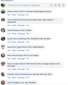
Our BRL Facebook page is lighting up with comments from all over the region.
Click on the image above to read all of the comments on our Facebook page.
Video: The moment a magnitude 5.1 earthquake struck near Sparta, North Carolina, this morning. The earthquake was the largest to hit North Carolina since 1916. pic.twitter.com/zei5mPstX7
PUBLIC INFORMATION STATEMENT
NATIONAL WEATHER SERVICE BLACKSBURG VA
928 AM EDT SUN AUG 9 2020

...PUBLIC INFORMATION STATEMENT...

...5.1 MAGNITUDE EARTHQUAKE NEAR SPARTA, NC....

PER THE USGS, A 5.1 MAGNITUDE EARTHQUAKE OCCURRED AT 8:07 AM EDT
THIS MORNING, WITH THE EPICENTER LOCATED 3 KM OR APPROXIMATELY
4.8
MILES SOUTHEAST OF SPARTA, NORTH CAROLINA. THIS FOLLOWED A MUCH
WEAKER EARTHQUAKE OF 2.6 MAGNITUDE THAT OCCURRED AT 1:57 AM EDT
THIS MORNING.

PLEASE GO TO THIS WEBSITE FOR ADDITIONAL INFORMATION CONCERNING
THIS EARTHQUAKE: HTTPS://EARTHQUAKE.USGS.GOV/EARTHQUAKES. THIS IS
THE VERY SAME INFORMATION THAT IS AVAILABLE TO US HERE AT THE
NATIONAL WEATHER SERVICE. THE NATIONAL WEATHER SERVICE NEITHER
MONITORS NOR FORECASTS EARTHQUAKES. THE UNITED STATES GEOLOGICAL
SURVEY (USGS) IS THE ONLY FEDERAL AGENCY WITH RESPONSIBILITY FOR
RECORDING AND REPORTING EARTHQUAKE ACTIVITY NATIONWIDE.
A Flash Flood Watch is in effect from noon Friday into the late night hours : August 7, 2020 for the areas shaded in green. Click on the image above for the absolute latest updates from NWS.
…FLASH FLOOD WATCH IS CANCELLED…
District of Columbia-Nelson-Albemarle-Greene-Madison-Orange-
Culpeper-Prince William/Manassas/Manassas Park-Fairfax-
Arlington/Falls Church/Alexandria-Southern Fauquier-
Northern Virginia Blue Ridge-Central Virginia Blue Ridge-
Including the cities of Washington, Lovingston, Charlottesville,
Stanardsville, Madison, Orange, Gordonsville, Culpeper,
Dale City, Manassas, Woodbridge, Lake Ridge, Montclair, Reston,
Herndon, Annandale, Centreville, Chantilly, McLean, Franconia,
Arlington, Alexandria, Falls Church, Turnbull, Big Meadows,
and Wintergreen
1014 PM EDT Fri Aug 7 2020
…FLASH FLOOD WATCH IS CANCELLED…
The Flash Flood Watch for portions of The District of Columbia
and Virginia has been cancelled.
The risk of flash flooding has ended.
FLASH FLOOD WATCH IN EFFECT FROM NOON EDT TODAY THROUGH LATE TONIGHT
Flood Watch
National Weather Service Baltimore MD/Washington DC
346 AM EDT Fri Aug 7 2020

District of Columbia-Frederick MD-Carroll-Northern Baltimore-
Southern Baltimore-Prince Georges-Anne Arundel-Charles-St. Marys-
Calvert-Northwest Montgomery-Central and Southeast Montgomery-
Northwest Howard-Central and Southeast Howard-Northwest Harford-
Southeast Harford-Augusta-Rockingham-Page-Nelson-Albemarle-Greene-
Madison-Rappahannock-Orange-Culpeper-
Prince William/Manassas/Manassas Park-Fairfax-
Arlington/Falls Church/Alexandria-Stafford-Spotsylvania-
King George-Northern Fauquier-Southern Fauquier-Western Loudoun-
Eastern Loudoun-Northern Virginia Blue Ridge-
Central Virginia Blue Ridge-
Including the cities of Washington, Frederick, Ballenger Creek,
Eldersburg, Westminster, Reisterstown, Cockeysville, Baltimore,
Bowie, Suitland-Silver Hill, Clinton, College Park, Greenbelt,
Laurel, Camp Springs, Glen Burnie, Annapolis, Severn, South Gate,
Severna Park, Arnold, Odenton, St. Charles, Waldorf,
Lexington Park, California, Chesapeake Beach, Huntingtown,
Dunkirk, North Beach, Lusby, Prince Frederick, Germantown,
Damascus, Bethesda, Rockville, Gaithersburg, Silver Spring,
Lisbon, Columbia, Ellicott City, Jarrettsville, Aberdeen,
Staunton, Waynesboro, Stuarts Draft, Harrisonburg, Luray,
Shenandoah, Stanley, Lovingston, Charlottesville, Stanardsville,
Madison, Orange, Gordonsville, Culpeper, Dale City, Manassas,
Woodbridge, Lake Ridge, Montclair, Reston, Herndon, Annandale,
Centreville, Chantilly, McLean, Franconia, Arlington, Alexandria,
Falls Church, Falmouth, Fredericksburg, Dahlgren, Warrenton,
Turnbull, Purcellville, Leesburg, Ashburn, Sterling, Big Meadows,
and Wintergreen
346 AM EDT Fri Aug 7 2020

...FLASH FLOOD WATCH IN EFFECT FROM NOON EDT TODAY THROUGH LATE
TONIGHT...

The National Weather Service in Sterling Virginia has issued a

* Flash Flood Watch for portions of Maryland, The District of
  Columbia, and Virginia, including the following areas, in
  Maryland, Anne Arundel, Calvert, Carroll, Central and
  Southeast Howard, Central and Southeast Montgomery, Charles,
  Frederick, Northern Baltimore, Northwest Harford, Northwest
  Howard, Northwest Montgomery, Prince Georges, Southeast
  Harford, Southern Baltimore, and St. Marys. The District of
  Columbia. In Virginia, Albemarle, Arlington/Falls
  Church/Alexandria, Augusta, Central Virginia Blue Ridge,
  Culpeper, Eastern Loudoun, Fairfax, Greene, King George,
  Madison, Nelson, Northern Fauquier, Northern Virginia Blue
  Ridge, Orange, Page, Prince William, Rappahannock, Rockingham,
  Southern Fauquier, Spotsylvania, Stafford, and Western
  Loudoun.

* From noon EDT today through late tonight

* Scattered slow moving showers and thunderstorms are expected
  this afternoon and tonight which may pose a risk of flash
  flooding.

PRECAUTIONARY/PREPAREDNESS ACTIONS...

A Flash Flood Watch means that conditions may develop that lead
to flash flooding. Flash flooding is a very dangerous situation.

You should monitor later forecasts and be prepared to take action
should Flash Flood Warnings be issued.
A Flash Flood Watch continues into Thursday evening : August 6, 2020 for the areas shaded in green. Click on the image above for the absolute latest updates from NWS.
FLASH FLOOD WATCH IN EFFECT THROUGH THIS EVENING
Flood Watch
National Weather Service Baltimore MD/Washington DC
246 AM EDT Thu Aug 6 2020
District of Columbia-Frederick MD-Carroll-Northern Baltimore-
Southern Baltimore-Prince Georges-Anne Arundel-Charles-St. Marys-
Calvert-Northwest Montgomery-Central and Southeast Montgomery-
Northwest Howard-Central and Southeast Howard-Northwest Harford-
Southeast Harford-Augusta-Nelson-Albemarle-Orange-
Prince William/Manassas/Manassas Park-Fairfax-
Arlington/Falls Church/Alexandria-Stafford-Spotsylvania-
King George-Northern Fauquier-Southern Fauquier-Western Loudoun-
Eastern Loudoun-Central Virginia Blue Ridge-
Including the cities of Washington, Frederick, Ballenger Creek,
Eldersburg, Westminster, Reisterstown, Cockeysville, Baltimore,
Bowie, Suitland-Silver Hill, Clinton, College Park, Greenbelt,
Laurel, Camp Springs, Glen Burnie, Annapolis, Severn, South Gate,
Severna Park, Arnold, Odenton, St. Charles, Waldorf,
Lexington Park, California, Chesapeake Beach, Huntingtown,
Dunkirk, North Beach, Lusby, Prince Frederick, Germantown,
Damascus, Bethesda, Rockville, Gaithersburg, Silver Spring,
Lisbon, Columbia, Ellicott City, Jarrettsville, Aberdeen,
Staunton, Waynesboro, Stuarts Draft, Lovingston, Charlottesville,
Orange, Gordonsville, Dale City, Manassas, Woodbridge,
Lake Ridge, Montclair, Reston, Herndon, Annandale, Centreville,
Chantilly, McLean, Franconia, Arlington, Alexandria,
Falls Church, Falmouth, Fredericksburg, Dahlgren, Warrenton,
Turnbull, Purcellville, Leesburg, Ashburn, Sterling,
and Wintergreen
246 AM EDT Thu Aug 6 2020
…FLASH FLOOD WATCH IN EFFECT THROUGH THIS EVENING…
The National Weather Service in Sterling Virginia has expanded
the
* Flash Flood Watch to include portions of Maryland, The
District of Columbia, and Virginia, including the following
areas, in Maryland, Anne Arundel, Calvert, Carroll, Central
and Southeast Howard, Central and Southeast Montgomery,
Charles, Frederick, Northern Baltimore, Northwest Harford,
Northwest Howard, Northwest Montgomery, Prince Georges,
Southeast Harford, Southern Baltimore, and St. Marys. The
District of Columbia. In Virginia, Albemarle, Arlington/Falls
Church/Alexandria, Augusta, Central Virginia Blue Ridge,
Eastern Loudoun, Fairfax, King George, Nelson, Northern
Fauquier, Orange, Prince William, Southern Fauquier,
Spotsylvania, Stafford, and Western Loudoun.
* Through this evening
* Numerous slow moving showers and thunderstorms continue to
develop across the region and should expand and redevelop with
time. Locations which are repetitively affected could receive
multiple-inch rainfall totals. This could lead to rapid rises on
streams and flash flooding of low lying areas.
PRECAUTIONARY/PREPAREDNESS ACTIONS…
A Flash Flood Watch means that conditions may develop that lead
to flash flooding. Flash flooding is a very dangerous situation.
You should monitor later forecasts and be prepared to take action
should Flash Flood Warnings be issued.
Flood Watch
National Weather Service Baltimore MD/Washington DC
246 AM EDT Thu Aug 6 2020
Rockingham-Page-Greene-Madison-Rappahannock-Culpeper- Northern Virginia Blue Ridge–
Including the cities of Harrisonburg, Luray, Shenandoah, Stanley,
Stanardsville, Madison, Washington, Culpeper, and Big Meadows
246 AM EDT Thu Aug 6 2020
…FLASH FLOOD WATCH NOW IN EFFECT THROUGH THIS EVENING…
The Flash Flood Watch is now in effect for
* Portions of central Virginia, northern Virginia, northwest
Virginia, and western Virginia, including the following areas,
in central Virginia, Greene. In northern Virginia, Culpeper.
In northwest Virginia, Madison, Northern Virginia Blue Ridge,
Page, and Rappahannock. In western Virginia, Rockingham.
* Through this evening
* Numerous slow moving showers and thunderstorms continue to
develop across the region and should expand and redevelop with
time. Locations which are repetitively affected could receive
multiple-inch rainfall totals. This could lead to rapid rises on
streams and flash flooding of low lying areas.
PRECAUTIONARY/PREPAREDNESS ACTIONS…
A Flash Flood Watch means that conditions may develop that lead
to flash flooding. Flash flooding is a very dangerous situation.
You should monitor later forecasts and be prepared to take action
should Flash Flood Warnings be issued.