Audiences are taken on a theatrical journey that the entire family can enjoy together. Children thrill as Santa takes the audience on a magical sleighride to the North Pole, while parents marvel at the unparalleled precision dance of the Rockettes. The Christmas Spectacular is truly unique in its universal appeal to people of all ages. From small children to grandparents, this dazzling holiday production is guaranteed to bring smiles to their faces and help create a wonderful family memory to last a lifetime.
Event Date: Monday 14th of December 2009 07:00 PM
Location/Address: John Paul Jones Arena/ 295 Massie Road, Charlottesville, VA 22903
Contact Telephone Please call 434-243-4960 for more information
Wintergreen Resort
Nelson County, Virginia
With the final weekend of July now in the history books, lazy Summer afternoon entertainment continued yesterday up at Wintergreen. The end of July as we head into August marks a slow transition with minds beginning to think about the coming school year. But, lots is still taking place between now and then with several more weeks to go!
Our Paul Purpura grabbed some shots from Discovery Ridge at Wintergreen Resort yesterday. Some of Nelson’s favorites, Jimbo and Kim Cary played into the afternoon and even let some of the kids there play along!
A youngster plays along Sunday afternoon at Discovery Ridge.A jump from the bungee at Discovery Ridge!
Severe Thunderstorm Watch #625 In Effect Until 9 PM EDT Sunday Evening, Via The NWS.*
Nelson County, Virginia *CANCELLED * CANCELLED * CANCELLED * CANCELLED *
URGENT – IMMEDIATE BROADCAST REQUESTED
SEVERE THUNDERSTORM WATCH NUMBER 625
NWS STORM PREDICTION CENTER NORMAN OK
210 PM EDT SUN JUL 26 2009
THE NWS STORM PREDICTION CENTER HAS ISSUED A
SEVERE THUNDERSTORM WATCH FOR PORTIONS OF
DISTRICT OF COLUMBIA
DELAWARE
MUCH OF MARYLAND
SOUTHERN NEW JERSEY
CENTRAL AND EASTERN VIRGINIA
COASTAL WATERS
EFFECTIVE THIS SUNDAY AFTERNOON AND EVENING FROM 210 PM UNTIL 900
PM EDT.
HAIL TO 1.5 INCHES IN DIAMETER…THUNDERSTORM WIND GUSTS TO 70
MPH…AND DANGEROUS LIGHTNING ARE POSSIBLE IN THESE AREAS.
THE SEVERE THUNDERSTORM WATCH AREA IS APPROXIMATELY ALONG AND 85
STATUTE MILES EAST AND WEST OF A LINE FROM 20 MILES EAST
SOUTHEAST OF SOUTH HILL VIRGINIA TO WILMINGTON DELAWARE. FOR A
COMPLETE DEPICTION OF THE WATCH SEE THE ASSOCIATED WATCH OUTLINE
UPDATE (WOUS64 KWNS WOU5).
REMEMBER…A SEVERE THUNDERSTORM WATCH MEANS CONDITIONS ARE
FAVORABLE FOR SEVERE THUNDERSTORMS IN AND CLOSE TO THE WATCH
AREA. PERSONS IN THESE AREAS SHOULD BE ON THE LOOKOUT FOR
THREATENING WEATHER CONDITIONS AND LISTEN FOR LATER STATEMENTS
AND POSSIBLE WARNINGS. SEVERE THUNDERSTORMS CAN AND OCCASIONALLY
DO PRODUCE TORNADOES.
DISCUSSION…STORMS HAVE RECENTLY DEVELOPED OVER SWRN VA AND ARE
EXPECTED TO INCREASE IN COVERAGE AND INTENSIFY THROUGH THE REMAINDER
OF THE AFTERNOON…AS THEY DEVELOP AND SPREAD NEWD INTO A MORE MOIST
AND UNSTABLE BOUNDARY LAYER. DEEP SWLY WINDS ABOVE THE BOUNDARY
LAYER WILL BE SUPPORTIVE OF LINE SEGMENTS/POSSIBLY BOWS…AND IN
COMBINATION WITH THE STEEP LOW LEVEL LAPSE RATES…WIND DAMAGE
SHOULD BE THE PRIMARY THREAT. HOWEVER…THE DEGREE OF
INSTABILITY…MLCAPES UP TO 3000 J/KG…WILL SUPPORT SEVERE HAIL
ALSO.
County Outline Area
SEVERE THUNDERSTORM WATCH 625 IS IN EFFECT UNTIL 900 PM EDT
FOR THE FOLLOWING LOCATIONS
ANNE ARUNDEL BALTIMORE CALVERT
CAROLINE CARROLL CECIL
CHARLES DORCHESTER FREDERICK
HARFORD HOWARD KENT
MONTGOMERY PRINCE GEORGES QUEEN ANNE’S
SOMERSET ST. MARYS TALBOT
WICOMICO WORCESTER
ACCOMACK ALBEMARLE AMELIA
APPOMATTOX ARLINGTON BRUNSWICK
BUCKINGHAM CAMPBELL CAROLINE
CHARLES CITY CHARLOTTE CHESTERFIELD
CULPEPER CUMBERLAND DINWIDDIE
ESSEX FAIRFAX FAUQUIER
FLUVANNA GLOUCESTER GOOCHLAND
GREENE GREENSVILLE HALIFAX
HANOVER HENRICO ISLE OF WIGHT
JAMES CITY KING AND QUEEN KING GEORGE
KING WILLIAM LANCASTER LOUDOUN
LOUISA LUNENBURG MADISON
MATHEWS MECKLENBURG MIDDLESEX NELSON NEW KENT NORTHAMPTON
NORTHUMBERLAND NOTTOWAY ORANGE
PITTSYLVANIA POWHATAN PRINCE EDWARD
PRINCE GEORGE PRINCE WILLIAM RAPPAHANNOCK
RICHMOND SOUTHAMPTON SPOTSYLVANIA
STAFFORD SURRY SUSSEX
WESTMORELAND YORK
VIRGINIA INDEPENDENT CITIES INCLUDED ARE
ALEXANDRIA CHARLOTTESVILLE CHESAPEAKE
COLONIAL HEIGHTS DANVILLE EMPORIA
FAIRFAX FALLS CHURCH FRANKLIN
FREDERICKSBURG HAMPTON HOPEWELL
MANASSAS MANASSAS PARK NEWPORT NEWS
NORFOLK PETERSBURG POQUOSON
PORTSMOUTH RICHMOND SUFFOLK
VIRGINIA BEACH WILLIAMSBURG
Sunday, August 2nd at 6pm, catch the jazz duo of Jennifer Kirkland. Musical excellence & versatility allow this duo to blend influences outside of jazz and then some! Enjoy some of our new menu items with Jason’s newest release of limited brews.
Event Date: Sunday 2nd of August 2009 06:00 PM
Location/Address: crossroads Rt 151 & Rt 664- Nelson County
Contact Telephone Please call 434.361.1001-www.dbbrewingcompany.com for more information
Sunday, August 2nd at 2pm, enjoy the sounds of Gary Randal on the DBBC Terrace while enjoying our fresh & original brews, handcrafted cocktails and delicious brunch specials. (weather permitting for outdoor entertainment)
Event Date: Sunday 2nd of August 2009 02:00 PM
Location/Address: crossroads Rt 151 & Rt 664- Nelson County
Contact Telephone Please call 434.361.1001-www.dbbrewingcompany.com for more information
Saturday, August 1st at 9pm, join DBBC for some outdoor dining with awesome views of Three Ridges Mtns and then catch The Moonrats who are a hip new blue country rock grass band!
Event Date: Saturday 1st of August 2009 09:00 PM
Location/Address: crossroads Rt 151 & Rt 664- Nelson County
Contact Telephone Please call 434.361.1001-www.dbbrewingcompany.com for more information
Fairfax County, Virginia
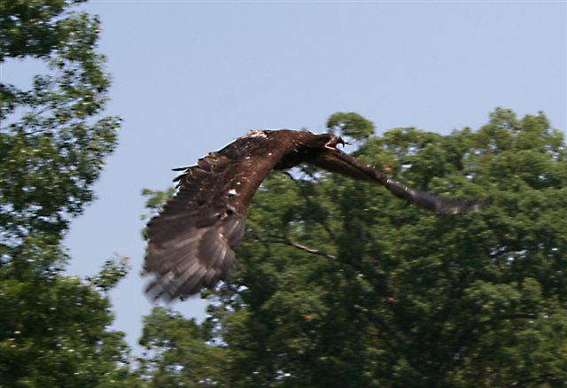
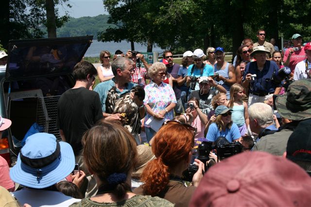
Rodes Farm residents, Henri and Elaine Weems got a rare treat Saturday afternoon. There were on hand as three bald eagles were released in Northern Virgina. A crowd of 300-500 folks looked on during the first triple release of eagles at Mason Neck State Park in Fairfax County, Virginia. You’ve seen many of the beautiful local Nelson photos Henri and Elaine have shared before.
The second of three eagles takes flight after release Saturday afternoon.
Henri and Elaine tells us people from all over the state and beyond attended the rare occasion where three eagles are release back into their natural habitat.
The huge crowd looks on as the eagles prepare for flight back into the wilderness.






 (2).jpg)