Wintergreen Resort
Nelson County, VA
Central Virginia dodged a major bullet with the passage of Hurricane Sandy to our north & east. But she did leave a beautiful late October backdrop of snow on the mountain at Wintergreen Resort in Nelson County. People living above 2000 feet got an early winter’s present on Halloween Eve! Depending on
Photo By Yvette Stafford : NCL/BRL Junior Publisher Adam Stafford walks through the wintry courtyard outside the Mountain Inn at Wintergreen Resort Tuesday afternoon October 30, 2012. Photo By Paul Purpura : This scene from the Blue Ridge Express ski lift at Wintergreen is more reminiscent of something you'd see in the heart of ski season, not approaching Halloween. Photo By Don Rhodes : Snow continued to fall around daybreak Tuesday - October 30, 2012 at Founders Vision Overlook just above Wintergreen Resort. Photo By Don Rhodes : Homes on Devils Knob were blanketed in a beautiful Halloween Eve snow Tuesday morning October 30, 2012 in Nelson County, VA
By late in the week temps will be back to near 60° in the valley, but still a nice preview of winter!
Chris Barksdale of Nellysford, Virginia, was one of 14 crew members rescued by the Coast Guard after abandoning the HMS Bounty. (c) NelsonCountyLife.com / Blue Ridge Life™ 2012
Nellysford native Chris Barksdale is alive after abandoning the HMS Bounty, about 90 miles southeast of Cape Hatteras, North Carolina. Barksdale was one of 14 crew members rescued from life rafts by the Coast Guard. A 15th crew member, Claudene Christian, 42, was pulled from the water unresponsive and was taken to Elizabeth City Hospital, according to a Coast Guard spokesman. Crews are still scanning the waters for the ship’s captain, Robin Walbridge, 63.
The Bounty had reportedly left Connecticut last week en route for St. Petersburg, Florida. The 180-foot, 3-mast vessel was built for the 1962 Marlon Brando movie “Mutiny on the Bounty.” It had issued a distress signal Sunday after taking on water and losing propulsion as Hurricane Sandy approached the East Coast of the United States.
Known locally as the “Honey-Do Handyman”, Barksdale’s friends and family closely monitored reports of the Coast Guard’s rescue mission Monday and were relieved to hear their friend survived the ordeal.
Via NWS: A variety of weather bulletins remain in effect for Central Virginia Blue Ridge Counties. A High Wind Warning and Blizzard Warnings continue into Tuesday.
URGENT – WINTER WEATHER MESSAGE
NATIONAL WEATHER SERVICE BALTIMORE MD/WASHINGTON DC
216 PM EDT MON OCT 29 2012
VAZ027-029-036>040-WVZ055-502-300230-
/O.EXB.KLWX.BZ.W.0001.121029T1816Z-121030T1800Z/
SHENANDOAH-PAGE-NELSON-ALBEMARLE-GREENE-MADISON-RAPPAHANNOCK-
HARDY-EASTERN GRANT-
INCLUDING THE CITIES OF…CHARLOTTESVILLE…WASHINGTON…
MOOREFIELD…PETERSBURG
216 PM EDT MON OCT 29 2012
…BLIZZARD WARNING IN EFFECT UNTIL 2 PM EDT TUESDAY…
THE NATIONAL WEATHER SERVICE IN BALTIMORE MD/WASHINGTON HAS
ISSUED A BLIZZARD WARNING…WHICH IS IN EFFECT UNTIL 2 PM EDT
TUESDAY.
* PRECIPITATION TYPE…HEAVY WET SNOW MIXING WITH RAIN AT TIMES.
* ACCUMULATIONS…6 TO 12 INCHES FOR ELEVATIONS ABOVE 2000 FEET.
* TIMING…SNOW WILL BE HEAVIEST THIS AFTERNOON AND EVENING.
PRECIPITATION WILL CONTINUE INTO TUESDAY AFTERNOON.
* TEMPERATURES…LOWER TO MIDDLE 30S.
* WINDS…WEST 30 TO 40 MPH WITH GUSTS UP TO 60 MPH.
* IMPACTS…IT IS LIKELY THAT THE COMBINATION OF STRONG WIND AND
HEAVY WET SNOW WILL DOWN TREE LIMBS AND POWER LINES. EXPECT NEAR
ZERO VISIBILITIES IN PERIODS OF HEAVY SNOW.
PRECAUTIONARY/PREPAREDNESS ACTIONS…
A BLIZZARD WARNING MEANS SEVERE WINTER WEATHER CONDITIONS ARE
EXPECTED OR OCCURRING. FALLING AND BLOWING SNOW WITH STRONG WINDS
AND POOR VISIBILITIES ARE LIKELY. THIS WILL LEAD TO WHITEOUT
CONDITIONS…MAKING TRAVEL EXTREMELY DANGEROUS. DO NOT TRAVEL. IF
YOU MUST TRAVEL…HAVE A WINTER SURVIVAL KIT WITH YOU. IF YOU GET
STRANDED…STAY WITH YOUR VEHICLE.
HIGH WIND WARNING REMAINS IN EFFECT UNTIL 8 PM EDT TUESDAY URGENT – WEATHER MESSAGE
NATIONAL WEATHER SERVICE BALTIMORE MD/WASHINGTON DC
1203 PM EDT MON OCT 29 2012
.HURRICANE SANDY WILL MOVE TO THE NORTHWEST TODAY…REACHING THE
SOUTHERN NEW JERSEY COAST TONIGHT. THE TRACK OF SANDY IS EXPECTED
TO BRING HIGH WINDS TO THE REGION THROUGH TUESDAY EVENING.
MDZ003-501-502-VAZ025>031-036>040-050-051-056-501>504-WVZ050>053-
055-501>506-300015-
/O.CON.KLWX.HW.W.0002.000000T0000Z-121031T0000Z/
WASHINGTON-EXTREME WESTERN ALLEGANY-CENTRAL AND EASTERN ALLEGANY-
AUGUSTA-ROCKINGHAM-SHENANDOAH-FREDERICK VA-PAGE-WARREN-CLARKE-
NELSON-ALBEMARLE-GREENE-MADISON-RAPPAHANNOCK-ORANGE-CULPEPER-
SPOTSYLVANIA-NORTHERN FAUQUIER-SOUTHERN FAUQUIER-WESTERN HIGHLAND-
EASTERN HIGHLAND-HAMPSHIRE-MORGAN-BERKELEY-JEFFERSON-HARDY-
WESTERN GRANT-EASTERN GRANT-WESTERN MINERAL-EASTERN MINERAL-
WESTERN PENDLETON-EASTERN PENDLETON-
INCLUDING THE CITIES OF…HAGERSTOWN…FROSTBURG…CUMBERLAND…
STAUNTON…WAYNESBORO…HARRISONBURG…WINCHESTER…FRONT ROYAL…
CHARLOTTESVILLE…WASHINGTON…CULPEPER…FREDERICKSBURG…
WARRENTON…HIGHTOWN…MONTEREY…MARTINSBURG…CHARLES TOWN…
MOOREFIELD…BAYARD…MOUNT STORM…PETERSBURG…ELK GARDEN…
KEYSER…FORT ASHBY…CIRCLEVILLE…FRANKLIN
1203 PM EDT MON OCT 29 2012
…HIGH WIND WARNING REMAINS IN EFFECT UNTIL 8 PM EDT TUESDAY…
* TIMING…WINDS WILL INCREASE STEADILY TODAY…WITH MAXIMUM
WIND GUSTS OCCURRING LATE THIS AFTERNOON THROUGH TUESDAY
MORNING.
* WINDS…SUSTAINED NORTHWEST WINDS INCREASING TO 30 TO 50 MPH…
WITH GUSTS IN EXCESS OF 60 MPH PARTICULARLY ALONG THE RIDGES.
* IMPACTS…A PROLONGED 24 HOUR HIGH WIND EVENT WILL TAKE PLACE
ACROSS THE WARNING AREA. COUPLED WITH HEAVY RAINS FROM SANDY…
THE HIGH WINDS WILL LEAD TO SIGNIFICANT TREE DAMAGE.
RESIDENTS… VISITORS…AND BUSINESSES ACROSS THE REGION SHOULD
PLAN FOR WIDESPREAD POWER AND COMMUNICATION OUTAGES.
PRECAUTIONARY/PREPAREDNESS ACTIONS…
BE PREPARED FOR EXTENDED POWER OUTAGES. IF YOU LIVE NEAR LARGE
TREES…REMAIN IN THE LOWER LEVEL OF YOUR HOME OR SEEK SHELTER
ELSEWHERE IF POSSIBLE.
REFRAIN FROM ANY UNNECESSARY TRAVEL AND STAY INDOORS.
™2012 Blue Ridge Life : Photo By Mountain Photographer Paul Purpura : Wet snow blankets the area in and around Wintergreen Resort Monday afternoon October 29, 2012.
Wintergreen Resort
Nelson County, Virginia Though Sandy hasn’t delivered the sort of punch our east coast neighbors are seeing, she had a trick or two up her sleeve. Blizzard Warnings were issued for many Central Virginia counties near the Blue Ridge for 6-12 inches of snow by Tuesday afternoon in the elevations of roughly 2000 feet and above. “Snow plowing operations are officially underway on Wintergreen Mountain,” said Curtis Sheets, Deputy Director of Wintergreen Property Owners Association and Wintergreen’s Fire Chief. By 6:30 PM John Taylor on Devils Knob told us he estimates about 4 inches of snow on the ground and it continues to fall.
“We have emergency shelters open in both Lovingston at the fire department and at the Rockfish Valley Fire Department if anyone needs emergency shelter,” said Nelson EMS Director Jaime Miller.
Some isolated power outages had been reported by late afternoon in Nelson County. Primarily in the northern section of the county in Afton.
Via CVEC Outage Registry: In addition to Nelson other isolated areas were out as of 5:30 PM October 29, 2012 - but outages were not widespread as of that time period.
™2012 Blue Ridge Life: Photo By Tommy Stafford : A gasoline tanker fills the ground tanks at Ashley's Market Sunday morning October 28, 2012 in Greenfield just north of Nellysford on VA Route 151.
Greenfield
Nelson County, VA Tommy’s been telling you about approaching hurricane Sandy for the past few days. Though the biggest concern will be for those along the Eastern Seaboard and points north and east. The Central Virginia area may see a prolonged period of high winds, widespread power outages, and moderate to heavy rains. The highest of winds would obviously be in the mountains.
It would be a good idea to fill up with gas now vs waiting. Remember those lines from the June Derecho? Avoid them. If we don't lose power, you still have a tank of gas!
Tommy is constantly following the storm now and will increase updates as Sandy gets closer. The Blue Ridge area should see the biggest impact on Monday into Tuesday as the storm is closest then slowly shifting north.
Te absolute best way to keep up with constant updates is on our Twitter feed. Second best, Facebook, and of course the latest warnings and updates are posted to your right on this page, scroll to Weather Bulletins.
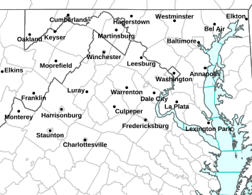
Via NWS: All areas shaded in light brown are under a High Wind Warning that takes effect from noon Monday until 8PM Tuesday. Additional flood watches will most likely be issued in the coming hours.
URGENT – WEATHER MESSAGE
NATIONAL WEATHER SERVICE BALTIMORE MD/WASHINGTON DC
356 AM EDT MON OCT 29 2012
.HURRICANE SANDY IS EXPECTED TO TRACK TO A POSITION APPROXIMATELY
300 MILES EAST OF NORFOLK VIRGINIA THIS MORNING…BEFORE TURNING TO
THE NORTHWEST AND REACHING THE COAST OVER SOUTHERN NEW JERSEY
AFTER MIDNIGHT. THE TRACK OF SANDY IS EXPECTED TO BRING HIGH WINDS
TO THE REGION THROUGH TUESDAY EVENING.
MDZ003-501-502-VAZ025>031-036>040-050-051-056-501>504-WVZ050>053-
055-501>506-291600-
/O.CON.KLWX.HW.W.0002.121029T1200Z-121031T0000Z/
WASHINGTON-EXTREME WESTERN ALLEGANY-CENTRAL AND EASTERN ALLEGANY-
AUGUSTA-ROCKINGHAM-SHENANDOAH-FREDERICK VA-PAGE-WARREN-CLARKE-
NELSON-ALBEMARLE-GREENE-MADISON-RAPPAHANNOCK-ORANGE-CULPEPER-
SPOTSYLVANIA-NORTHERN FAUQUIER-SOUTHERN FAUQUIER-WESTERN HIGHLAND-
EASTERN HIGHLAND-HAMPSHIRE-MORGAN-BERKELEY-JEFFERSON-HARDY-
WESTERN GRANT-EASTERN GRANT-WESTERN MINERAL-EASTERN MINERAL-
WESTERN PENDLETON-EASTERN PENDLETON-
INCLUDING THE CITIES OF…HAGERSTOWN…FROSTBURG…CUMBERLAND…
STAUNTON…WAYNESBORO…HARRISONBURG…WINCHESTER…FRONT ROYAL…
CHARLOTTESVILLE…WASHINGTON…CULPEPER…FREDERICKSBURG…
WARRENTON…HIGHTOWN…MONTEREY…MARTINSBURG…CHARLES TOWN…
MOOREFIELD…BAYARD…MOUNT STORM…PETERSBURG…ELK GARDEN…
KEYSER…FORT ASHBY…CIRCLEVILLE…FRANKLIN
356 AM EDT MON OCT 29 2012
…HIGH WIND WARNING REMAINS IN EFFECT FROM 8 AM THIS MORNING TO
8 PM EDT TUESDAY…
* TIMING…WIND GUSTS OVER 45 MPH ARE EXPECTED TO OVERSPREAD THE AREA
BY LATE MORNING. WIND GUSTS UP TO 60 MPH ARE EXPECTED THIS
EVENING INTO TUESDAY EVENING…PARTICULARLY ALONG THE RIDGES.
* IMPACTS…A PROLONGED 24 HOUR HIGH WIND EVENT WILL TAKE PLACE
ACROSS THE WARNING AREA. COUPLED WITH HEAVY RAINS FROM SANDY…THE
HIGH WINDS WILL LEAD TO SIGNIFICANT TREE DAMAGE. RESIDENTS…
VISITORS…AND BUSINESSES ACROSS THE REGION SHOULD PLAN FOR
WIDESPREAD POWER AND COMMUNICATION OUTAGES.
PRECAUTIONARY/PREPAREDNESS ACTIONS…
BE PREPARED FOR EXTENDED POWER OUTAGES. IF YOU LIVE NEAR LARGE
TREES…REMAIN IN THE LOWER LEVEL OF YOUR HOME OR SEEK SHELTER
ELSEWHERE IF POSSIBLE.
REFRAIN FROM ANY UNNECESSARY TRAVEL AND STAY INDOORS.
™Blue Ridge Life : Photos By Tommy Stafford : Bill Schutte of Afton (right) stands next to one of the tents taken down Saturday afternoon October 27, 2012 at The Nelson Farmers Market in Nellysford. The season officially ended this past weekend until 2014.
Nellysford
Nelson County, VA
You know the cold winds of winter aren’t very far away when the tents come down at the Nelson Farmers Market Coop in Nellysford. The 2012 market kicked off back in early May. After a fantastic season, this weekend marked the end of the 2013 season. This is actually the second time people at the market have had to put their hands on the tents. The June Derecho totally destroyed the tents. They were replaced later in the summer.
Volunteers help lower the top portion of the market tents to the ground this past Saturday - October 27, 2012 in Nellysford, VAAnnie Mooney of Piney River (right) is all smiles after a successful 2012 market season in Nellysford.
™ 2012 Blue Ridge Life : Photos By Tommy Stafford : In the foreground (L) Foxie Morgan of Pharsalia in Tyro and Heidi Crandall of Devils Backbone in Roseland chat it up among the crowd Friday night October 26, 2012 during the Opportunity Ball held at Veritas Winery & Vineyards.
Afton
Nelson County, Virginia
For the 7th year in a row crowds packed the Veritas Ballroom in Afton for the annual Opportunity Ball. The event raises money for various Nelson charities as part of the Nelson County Community Fund. We’ve been telling you about the event for several years. This year you could pretty much come dressed as anything you wanted as the theme was a lighter Halloween costume or many dressed in standard formal wear for a ball.
Andrew Hodson (L) and wife Patricia, founders and owners of Veritas Winery & Vineyards show off their halloween best as they headed into the Opportunity Ball this past Friday - October 26, 2012Dave Schweninger, AKA Cash Cow, chats it up with NCL/BRL Publisher Yvette Stafford at the 2012 Opportunity Ball held this past Friday evening October 27, 2012 at Veritas in Afton, VADr. & Mrs. Tom Krop of Afton laugh it up in their Halloween best at the Opportunity Ball this past Friday evening October 26, 2012 held at Veritas. Joe Steel with the Opportunity Ball says thanks to all of the volunteers and supporters at the Friday night's Ball. Guests were treated to a gourmet meal and several different pairings of wine from Veritas. People enjoying the evening in the ballroom at Veritas during Opportunity Ball 2012.
Via Wunderground.com: A current satellite view of Hurricane Sandy as she makes her way toward the coast of Virginia and points north.
Nelson County, Virginia
Everyone is wondering what Hurricane Sandy will do over the coming days as she spins northward along the eastern seaboard of the US. Friday, Virginia Governor Bob McDonnell, issued a state of emergency for the entire state in preparation of Sandy. Friday afternoon weather models showed Sandy to make landfall Monday into Tuesday somewhere near the Delmarva. Other Friday models show that shifting a bit north, better news for Central Virginians.
Via Wunderground.com : Sandy's current position and 5 day projections.
Regardless, the Central Virginia Blue Ridge will see some effects from the storm. Primarily gusty winds, and possible heavy rains Sunday night into Monday. There’s also the possibility of some snow in the highest of elevations, especially in Western Virginia and Eastern West Virginia.
Tommy will be keeping up with the storm over the weekend and updating as necessary.
™2012 Blue Ridge Life : Photos By BRL Mountain Photographer Paul Purpura : The Nelson County High School Classes of 1962-1966 met this past weekend as part of their reunion. The class of 1962 was honored recently for their 50th year since graduating from NCHS.
Lovingston
Nelson County, VA
50 Years ago students with the NCHS Class of 1962 graduated. 5 decades later this past weekend they got back together to remember on their time there. “The Nelson County High School Classes of 1962-1966 have held a joint class reunion for the past several years and from that we have been able to fund a scholarship each year to a NCHS student in memory of Catherine Whitehead, who was our guidance counselor,” said Dolores Saunders Hill
Mary Catherine Flythe and Jim Garwood happily conversing at the NCHS 1962 Class Reunion
Congrats on 50 years!
Additional pictures are accessible at Paul Purpura’s web-site (www.photographybypaulpurpura.zenfolio.com). When Paul’s home page comes up, place your mouse over “Portfolios” in the lower left and a sub-menu listing accessible portfolios will pop up.