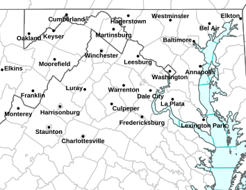
Via NWS: Many areas across the Blue Ridge are under Wind Advisories Thursday evening until Friday morning.
WIND ADVISORY IN EFFECT FROM MIDNIGHT TONIGHT TO 8 AM EDT FRIDAY URGENT – WEATHER MESSAGE
NATIONAL WEATHER SERVICE BALTIMORE MD/WASHINGTON DC
401 AM EDT FRI NOV 1 2013
MDZ003-004-501-502-VAZ025>031-036>040-042-501-503-504-WVZ050>053-
055-501>506-011600-
/O.EXT.KLWX.WI.Y.0006.000000T0000Z-131101T1600Z/
WASHINGTON-FREDERICK MD-EXTREME WESTERN ALLEGANY-
CENTRAL AND EASTERN ALLEGANY-AUGUSTA-ROCKINGHAM-SHENANDOAH-
FREDERICK VA-PAGE-WARREN-CLARKE-NELSON-ALBEMARLE-GREENE-MADISON-
RAPPAHANNOCK-LOUDOUN-NORTHERN FAUQUIER-WESTERN HIGHLAND-
EASTERN HIGHLAND-HAMPSHIRE-MORGAN-BERKELEY-JEFFERSON-HARDY-
WESTERN GRANT-EASTERN GRANT-WESTERN MINERAL-EASTERN MINERAL-
WESTERN PENDLETON-EASTERN PENDLETON-
INCLUDING THE CITIES OF…HAGERSTOWN…FREDERICK…FROSTBURG…
CUMBERLAND…STAUNTON…WAYNESBORO…HARRISONBURG…WINCHESTER…
FRONT ROYAL…CHARLOTTESVILLE…WASHINGTON…LEESBURG…
WARRENTON…HIGHTOWN…MONTEREY…MARTINSBURG…CHARLES TOWN…
MOOREFIELD…BAYARD…MOUNT STORM…PETERSBURG…ELK GARDEN…
KEYSER…FORT ASHBY…CIRCLEVILLE…FRANKLIN
401 AM EDT FRI NOV 1 2013
…WIND ADVISORY NOW IN EFFECT UNTIL NOON EDT TODAY…
* TIMING…STRONGEST WINDS WILL OCCUR EARLY THIS MORNING BEFORE
GRADUALLY WEAKENING LATE IN THE MORNING.
* WINDS…SOUTH 20 TO 30 MPH WITH GUSTS UP TO 50 MPH IN THE HIGHER
ELEVATIONS.
* IMPACTS…SCATTERED TREE AND POWER LINE DAMAGE. DIFFICULTY
DRIVING HIGH PROFILE VEHICLES. IMPACTS WILL BE MOST PRONOUNCED
ACROSS THE RIDGE TOPS…AT ELEVATIONS ABOVE 1500 FEET.
PRECAUTIONARY/PREPAREDNESS ACTIONS…
A WIND ADVISORY MEANS THAT WIND GUSTS OF 45 TO 55 MPH ARE
EXPECTED. SECURE OUTDOOR FURNITURE AND TAKE CARE DRIVING HIGH
PROFILE VEHICLES.
Confidence Climb obstacle at Nasty 001. Photo courtesy: GORUCK
It was like I was a second grader again in Ms. Murphy’s P.E. class. I grabbed onto the rope and slowly, hand over hand, I pulled my body up an exhilarating 20 feet. But this time, I didn’t hear a “Good job, Yvette” from a gym teacher in striped tube socks. Instead, a newfound fear of heights kicked in and assaulted my confidence. Climbing a rope was one thing. The thought of walking across a lattice of beams was crippling. I collected myself, leaned over the railing, and dropped an F bomb.
Climbing a rope, just like in gym class. Photo courtesy: GORUCK
Tyler, one of the GORUCK cadre assigned to the obstacle, heard my loud whisper. The other rope climbers had started walking across the beams when Tyler, whose longish hair peaked out of a tactical hat, asked me why I wasn’t walking.
“I can’t stop shaking,” I told him, raising my trembling right arm.
“Why are you shaking?” he asked, matter-of-factly. “Are you tired or are you afraid of heights?”
“I think I’m afraid of heights,” I told him.
“Hold my hand. Lets walk.”
I honestly don’t remember if he gave me his whole hand or if he just lent me the tip of his finger. Whatever he did, it worked. I turned over my fear to a stranger and made it to the other side.
“Thank you, thank you, thank you,” I repeated, as I proceeded to climb up a latter and down a cargo net to complete the obstacle.
“People are stronger than they think they are. With just a little but of push, a little bit of confidence, you’ll be okay,” said Devin Reagan, one of the masterminds behind the GORUCK Nasty course design. A Green Beret, Devin modeled this year’s Nasty (Nasty 001) after the Nasty Nick, the course he and other Berets went through during Special Forces training. Like the Tough Mudder and Spartan obstacle course races, the Nasty has its share of wall climbs and muddy crawls. But unlike the other races, the Nasty jolts you out of your comfort zone, obstacle course race veteran or not.
If you don’t make it across, splash! Photo courtesy: GORUCKYes, there is light at the end of the tunnel. Photo courtesy: GORUCK
“These aren’t obstacles that are just up and over,” Devin explained. “But with a little bit of coaxing and a little bit of coaching, [people] are able to accomplish [them].”
It’s true. In no other course I’ve gone through has there been a Special Forces cadre assigned to each obstacle to drown out the negative voices in your head. Luke Skywalker had Yoda. I had Tyler.
As we hiked up one of several slopes at Massanutten Resort, we saw several men of various fitness levels pausing along the way, hoping a time-out would ease their mental and physical exhaustion. But the “suck” hung over us like the blanket of fog that made our trek to the Mogadishu Mile obstacle even more surreal. The scene was cinematic, and at times, nightmarish. Tired souls emerging from clouds, dirty and wet, holding small flags that would be placed on a Memorial Wall. It wasn’t until we reached the top of that ascent, did we get to enjoy a break, a damp and relaxing jog on a gravel road that led to a series of log balance beams.
GORUCK is known for making tough stuff that attracts a cult-like following. Crafted in Montana, its rucks have been “used and abused” in war by Special Forces soldiers (GORUCK’s founder, Jason McCarthy, is himself a former Green Beret). The company believes in its products so much, it offers a lifetime guarantee. Prior to the GORUCK Nasty, the Challenge was the only way anyone could get in some “good livin'” and earn the coveted Challenge patch, which conveniently adheres to your ruck. The Cadre-led team event lasts several hours and is held at various cities around the country. I earned my patch in the chilly ocean waters of Virginia Beach in April 2012.
As for Nasty 002, current plans are to hold it at Massanutten Resort in August or September 2014; Nasty 003 will be elsewhere in the continental U.S, and its location is expected to be disclosed soon. Devin said Nasty 002’s participants can look forward to more activities tailored for families. For now, the primary focus will be on perfecting the event.
“The more confidence challenging obstacles, the better. That’s what we’re going to focus on.”
Daylight Saving Time ends this weekend on Sunday – November 3, 2013 at 2AM, for simplicity’s sake it’s easier to turn your clock back one hour before bed on Saturday night.
Daylight Saving Time officially ends at 2AM this coming Sunday morning – November 3, 2013 at 2AM. But it’s a lot easier to just set your clock back one hour before bed on Saturday night. That is unless you are a party animal and you’re still going at 2AM!
We won’t return to Daylight Saving Time until next year in 2014 on March 9th.
So long – longer days until next year!
Trivia, the shortest daylight of the year falls on the first day of winter, which is Saturday, December 21, 2013. From then on we gain a tiny fraction of daylight each day.
Roseland
Nelson County, VA
Halloween is just around the corner so no better time to hold the Trail of Terror II 5 & 10K night run this past Saturday night at Devils Playground. That’s the trail system just across the way from Devils Backbone Brewing. Blue Ridge Life Magazine is a regular sponsor of the unique runs that always include a kids fun run just before the main race. This year every kid runner got the first of our really neat BRLM winter beanies (see Juniorette Publisher Peyton Stafford below showing one of them off) that go on sale soon in our online store.
Laura Wolf helps coordinate the kids fun run that kicked off about 30 minutes before dark fell and the main race started. Laura and buddy Kerri Faust always help set up the fun run at each race.To see all of the pics from Saturday – October 26, 2013 Trail of Terror II, click on our Facebook album shot above.
Pink ribbons with Alexis’ picture were sold at Friday night’s football game against Campbell County. The money raised was given to the family of Alexis Murphy to help with expenses. October 25, 2013
“makes grants to local charitable organizations and agencies with the expressed goal of improving the life of Nelson County residents. Much of the work is accomplished by collaborating with nonprofits, funders, community leaders, and other partners to tackle important issues in our county. The NCCF operates under the charter of the Charlottesville Area Community Foundation – a 501c3 organization”
In addition to great food, wine and beer, people successfully bidding on auction items got trips, dinner and more.
BRLM Hdq.
Nelson County, VA
Within the past few days we put the finishing touches on our mobile version of blueridgelife.com. If you access our site for breaking news, weather, or whatever, it makes navigating lots easier! You can click on the menu button on the upper left hand side to get to whatever you want on our site. Nifty!
You don’t have to do a thing, your phone knows that it needs to switch to mobile formatting when coming here.
If you want to see the traditional desktop version just scroll to the bottom and click on View Full Site, that’s all there is too it!
Via NWS: Areas shaded in light green are under freeze warnings until early Friday morning – Darker blue areas Freeze Watches – Click on image for latest updates.
FREEZE WARNING URGENT – WEATHER MESSAGE
NATIONAL WEATHER SERVICE BALTIMORE MD/WASHINGTON DC
1140 AM EDT FRI OCT 25 2013
DISTRICT OF COLUMBIA-FREDERICK MD-CARROLL-NORTHERN BALTIMORE-
HARFORD-MONTGOMERY-HOWARD-SOUTHERN BALTIMORE-PRINCE GEORGES-
ANNE ARUNDEL-CHARLES-ST. MARYS-CALVERT-NELSON-ALBEMARLE-GREENE-
MADISON-RAPPAHANNOCK-LOUDOUN-ORANGE-CULPEPER-
PRINCE WILLIAM/MANASSAS/MANASSAS PARK-FAIRFAX-
ARLINGTON/FALLS CHURCH/ALEXANDRIA-STAFFORD-SPOTSYLVANIA-
KING GEORGE-NORTHERN FAUQUIER-SOUTHERN FAUQUIER-
INCLUDING THE CITIES OF…WASHINGTON…FREDERICK…WESTMINSTER…
GAITHERSBURG…COLUMBIA…BALTIMORE…ANNAPOLIS…WALDORF…
ST MARYS CITY…CHARLOTTESVILLE…LEESBURG…CULPEPER…
MANASSAS…MANASSAS PARK…FAIRFAX…ALEXANDRIA…FALLS CHURCH…
FREDERICKSBURG…WARRENTON
1140 AM EDT FRI OCT 25 2013
…FREEZE WARNING IN EFFECT FROM MIDNIGHT TONIGHT TO 9 AM EDT
SATURDAY…
THE NATIONAL WEATHER SERVICE IN BALTIMORE MD/WASHINGTON HAS
ISSUED A FREEZE WARNING…WHICH IS IN EFFECT FROM MIDNIGHT
TONIGHT TO 9 AM EDT SATURDAY.
* TEMPERATURES…UPPER 20S AND LOWER 30S.
* IMPACTS…UNPROTECTED VEGETATION SENSITIVE TO FREEZING
TEMPERATURES WILL BE KILLED OR DAMAGED.
PRECAUTIONARY/PREPAREDNESS ACTIONS…
A FREEZE WARNING MEANS SUB-FREEZING TEMPERATURES ARE EXPECTED.
THESE CONDITIONS WILL KILL SENSITIVE CROPS AND OTHER VEGETATION.
URGENT – WEATHER MESSAGE
NATIONAL WEATHER SERVICE BLACKSBURG VA
939 AM EDT FRI OCT 25 2013
…FREEZING CONDITIONS EXPECTED TONIGHT INTO EARLY SATURDAY…
.COLD HIGH PRESSURE WILL SETTLE ACROSS THE REGION BY TONIGHT
BRINGING A HARD FREEZE TO THE REGION.
NCZ003>006-019-020-VAZ032>035-043>047-058-059-252100-
/O.CON.KRNK.FZ.W.0007.131026T0400Z-131026T1300Z/
SURRY-STOKES-ROCKINGHAM-CASWELL-WILKES-YADKIN-PATRICK-FRANKLIN-
BEDFORD-AMHERST-HENRY-PITTSYLVANIA-CAMPBELL-APPOMATTOX-BUCKINGHAM-
HALIFAX-CHARLOTTE-
INCLUDING THE CITIES OF…DOBSON…DANBURY…EDEN…YANCEYVILLE…
WILKESBORO…YADKINVILLE…STUART…ROCKY MOUNT…BEDFORD…
AMHERST…MARTINSVILLE…DANVILLE…LYNCHBURG…APPOMATTOX…
SOUTH BOSTON…KEYSVILLE
939 AM EDT FRI OCT 25 2013
…FREEZE WARNING REMAINS IN EFFECT FROM MIDNIGHT TONIGHT TO 9 AM
EDT SATURDAY…
* LOCATIONS….PIEDMONT AND FOOTHILLS OF SOUTHWEST VIRGINIA AND
NORTHWEST NORTH CAROLINA.
* HAZARDS…A HARD FREEZE ENDING THE GROWING SEASON.
* TEMPERATURES…LOWS IN THE LOWER 20S TO AROUND 30.
* TIMING…TONIGHT INTO SATURDAY MORNING.
* IMPACTS…DAMAGE TO VEGETATION AND CROPS.
PRECAUTIONARY/PREPAREDNESS ACTIONS…
A FREEZE WARNING MEANS SUB-FREEZING TEMPERATURES ARE IMMINENT OR
HIGHLY LIKELY. THESE CONDITIONS WILL KILL CROPS AND OTHER
SENSITIVE VEGETATION.
The Trail of Terror Fun Run is back again this coming weekend on Saturday – October 26th. BRLM is again a sponsor of the spooky run & fun run!
Roseland
Nelson County, VA
Let the Fright begin….. again! In search of the Ichabod Crandall, with torches (headlamps) lit, you will search the trails of Basecamp in Nelson Co. With a glimmer of light, your course will be shown. Ghouls and goblins are around the next corner. The sounds of the Mississippi Leghounds will guide you to your finish where libations and Hallowish festivities await!
And if you are one of the cool kids, we know you are, you just may end up with one of our cool, but very warm, BRLM beanies!
5k, 10k Course choices
Costumes (not required but you may want to… just saying)
Costume Contest, libations and gruel following the run
Live music from the Mississippi Leghounds
Primitive Campground avail while space allows(only 20 spots)
FREEZE WATCH REMAINS IN EFFECT FROM LATE THURSDAY NIGHT THROUGH FRIDAY MORNING URGENT – WEATHER MESSAGE
NATIONAL WEATHER SERVICE BALTIMORE MD/WASHINGTON DC
530 PM EDT WED OCT 23 2013
WASHINGTON-FREDERICK MD-CARROLL-NORTHERN BALTIMORE-HARFORD-
MONTGOMERY-HOWARD-EXTREME WESTERN ALLEGANY-
CENTRAL AND EASTERN ALLEGANY-AUGUSTA-ROCKINGHAM-SHENANDOAH-
FREDERICK VA-PAGE-WARREN-CLARKE-NELSON-ALBEMARLE-GREENE-MADISON-
RAPPAHANNOCK-LOUDOUN-ORANGE-CULPEPER-
PRINCE WILLIAM/MANASSAS/MANASSAS PARK-FAIRFAX-NORTHERN FAUQUIER-
SOUTHERN FAUQUIER-HAMPSHIRE-MORGAN-BERKELEY-JEFFERSON-HARDY-
WESTERN MINERAL-EASTERN MINERAL-
INCLUDING THE CITIES OF…HAGERSTOWN…FREDERICK…WESTMINSTER…
GAITHERSBURG…COLUMBIA…FROSTBURG…CUMBERLAND…STAUNTON…
WAYNESBORO…HARRISONBURG…WINCHESTER…FRONT ROYAL…
CHARLOTTESVILLE…WASHINGTON…LEESBURG…CULPEPER…MANASSAS…
MANASSAS PARK…FAIRFAX…WARRENTON…MARTINSBURG…
CHARLES TOWN…MOOREFIELD…ELK GARDEN…KEYSER…FORT ASHBY
530 PM EDT WED OCT 23 2013
…FREEZE WATCH REMAINS IN EFFECT FROM LATE THURSDAY NIGHT
THROUGH FRIDAY MORNING…
* TEMPERATURES…IN THE LOWER 30S.
* IMPACTS…UNPROTECTED VEGETATION THAT IS SENSITIVE TO FREEZING
TEMPERATURES HAS THE POTENTIAL TO BE KILLED OR DAMAGED.
PRECAUTIONARY/PREPAREDNESS ACTIONS…
A FREEZE WATCH MEANS SUB-FREEZING TEMPERATURES ARE POSSIBLE.
THESE CONDITIONS COULD KILL CROPS AND OTHER SENSITIVE VEGETATION.
URGENT – WEATHER MESSAGE
NATIONAL WEATHER SERVICE BLACKSBURG VA
242 PM EDT WED OCT 23 2013
…COLD TEMPERATURES EXPECTED OVERNIGHT…
.MUCH COLDER AIR WILL RUSH INTO THE AREA BEHIND A COLD FRONT
THIS EVENING INTO TONIGHT. THIS WILL CAUSE TEMPERATURES TO FALL
INTO THE UPPER 20S TO THE MID 30S LATER TONIGHT INTO EARLY
THURSDAY.
NCZ002>006-019-020-VAZ010>014-016>019-022>024-032>035-043>047-058-
059-WVZ044-240245-
/O.NEW.KRNK.FR.Y.0005.131024T0600Z-131024T1300Z/
ALLEGHANY NC-SURRY-STOKES-ROCKINGHAM-CASWELL-WILKES-YADKIN-BLAND-
GILES-WYTHE-PULASKI-MONTGOMERY-CARROLL-FLOYD-CRAIG-ALLEGHANY VA-
ROANOKE-BOTETOURT-ROCKBRIDGE-PATRICK-FRANKLIN-BEDFORD-AMHERST-
HENRY-PITTSYLVANIA-CAMPBELL-APPOMATTOX-BUCKINGHAM-HALIFAX-
CHARLOTTE-MONROE-
INCLUDING THE CITIES OF…SPARTA…DOBSON…DANBURY…EDEN…
YANCEYVILLE…WILKESBORO…YADKINVILLE…BLAND…PEARISBURG…
WYTHEVILLE…RADFORD…PULASKI…BLACKSBURG…GALAX…FLOYD…
NEW CASTLE…CLIFTON FORGE…COVINGTON…ROANOKE…SALEM…
FINCASTLE…LEXINGTON…BUENA VISTA…STUART…ROCKY MOUNT…
BEDFORD…AMHERST…MARTINSVILLE…DANVILLE…LYNCHBURG…
APPOMATTOX…SOUTH BOSTON…KEYSVILLE…UNION
242 PM EDT WED OCT 23 2013
…FROST ADVISORY IN EFFECT FROM 2 AM TO 9 AM EDT THURSDAY…
THE NATIONAL WEATHER SERVICE IN BLACKSBURG HAS ISSUED A FROST
ADVISORY…WHICH IS IN EFFECT FROM 2 AM TO 9 AM EDT THURSDAY.
* LOCATIONS…PORTIONS OF SOUTHWEST VIRGINIA AND NORTHWEST NORTH
CAROLINA.
* TEMPERATURES…FROM 33 TO 36 DEGREES.
* TIMING…LATE TONIGHT INTO EARLY THURSDAY MORNING.
* IMPACTS…AREAS OF FROST WILL LIKELY DEVELOP EARLY THURSDAY
MORNING. THOSE WITH AGRICULTURAL INTERESTS ARE ADVISED TO
PROTECT TENDER VEGETATION. ALSO…SENSITIVE POTTED PLANTS THAT
ARE NORMALLY LEFT OUTDOORS SHOULD BE COVERED OR BROUGHT INSIDE
AWAY FROM THE COLD.
PRECAUTIONARY/PREPAREDNESS ACTIONS…
A FROST ADVISORY MEANS THAT FROST IS POSSIBLE. SENSITIVE OUTDOOR
PLANTS MAY BE KILLED IF LEFT UNCOVERED.