Nellysford
Nelson County, VA
By far the worst snowfall and wintry weather was along the souther tier of the US. But we managed to get some very dry snow here across the Central Virginia Blue Ridge in spots. Anywhere from a dusting to an inch or so was the norm. Since the air was so dry we got some pretty perfectly shaped flakes as Danny Watson captured in the photo above.
Wintergreen Resort
Nelson County, VA
Cold winter weather made a perfect backdrop for the 10 annual Wounded Warriors weekend held at Wintergreen Resort. The event is a collaborative effort between Wintergreen Adaptive Sports and the resort.
Wounded Warrior Christopher Semple of Hampton, Va is flanked by his instructors, Nathan Burns of Charlottesville, VA (left) and Mark Meardon of Richmond, VA (right) at the 10th annual Wounded Warriors Weekend held Jan 24th & 25th 2014 at Wintergreen Resort.
From the WAS website:
“Warrior Weekend included lodging, lift tickets, equipment, adaptive instruction, resort activities, meals, and a special banquet on Saturday.Hosting wounded veterans and their families, the entire Wintergreen Resort and community looks forward each year to honoring and welcoming these special members of the WAS family. WAS is proud to sponsor this fun and exciting weekend, during which the spouses and children of the honored veterans are also welcomed to all activities, including ski or snowboard lessons.
Warrior Weekend is supported by Disabled Sports USA, Warfighter Sports, Anthem Blue Cross and Blue Shield Foundation, Walter Reed Army Hospital, the Wounded Warrior Barracks at Camp Lejeune, the Fort Eustis Wounded Warrior Transition Unit, the Martinsburg West Virginia and the Hampton Roads Virginia Veterans Affairs Hospitals, the USO, the Bama Works Fund of the David Mathews Band of the Charlottesville Area Community Foundation, Northrop Grumman Corporation, Boeing Corporation, BAE Systems, The Colony Group, the Warren G. Stambough Memorial Foundation and hundreds of individuals and members of VFWs and American Legions.
“One of my employee’s brother’s house burned this morning, just past
Roseland post office, on left. Timmy and Amy Brown.
Daughter Candice 4th grade size 8 clothes, size 2 shoe
Daughter Courtney Kindergarten size 7 clothes, size 1 shoe
Amy is a size 1 clothes, size 7 shoes. Timmy wears 30 x30 pants, size 10 1/2
shoes.
My employee is Viola.
Things could be brought to Mac’s for them to pick up if anyone has anything.
We also have a money jar.
Thanks”
Below is a new piece that ABC-13 in Lynchburg did on the fire. WSET.com – ABC13
Anyone that can help out is encouraged to drop off what they can at Mac’s Country Store in Roseland. It’s just north of the Crabtree Falls (Route 56W) Highway and Route 151 intersection.
Photo Copyright 2014 Ned Martin. Reflecting the sun. Looking south from Wintergreen down the valley.
Wintergreen Mountain
Nelson County, VA
Yes, the cold temps have been, well, mighty cold. But the recent snowfall the Blue Ridge area got has made for some pretty scenes. Ned Martin of Wintergreen shared this photo with us on our Facebook Page early Saturday morning. This is one of the prettiest shots we have ever seen. Ned says this, “Looking south from Wintergreen down the valley.”
Saturday Morning Update 1.25.13 – from Betty Brown, owner of Mac’s Country Store in Roseland:
One of my employee’s brother’s house burned this morning, just past
Roseland post office, on left. Timmy and Amy Brown.
Daughter Candice 4th grade size 8 clothes, size 2 shoe
Daughter Courtney Kindergarten size 7 clothes, size 1 shoe
Amy is a size 1 clothes, size 7 shoes. Timmy wears 30 x30 pants, size 10 1/2
shoes.
My employee is Viola –
Things could be brought to Mac’s for them to pick up if anyone has anything.
We also have a money jar.
Thanks
Original story from 1.24.14
Piney River Fire, Lovingston Fire, Wintergreen Fire and Roseland Rescue all battled an early morning fire in Roseland that left the family uninjured but homeless and sadly losing their pets in the fire. Crews responded to the fire just after 8AM Friday morning to a house just north of the Roseland Post Office along Route 151. One fireman telling BRL,”Just a sad day all around, but thankfully the family was uninjured.”
Fire crews battled temps in the single digits to fight the fire and VDOT crews had to help keep the roadway clear from ice as water from the pumpers froze.
BRL understands the family displaced is living with other relatives until other arrangements can be made.
Editor’s note:
If anyone knows how we can help coordinate relief to the family, please comment below or drop us an email and we’ll be glad to help spread the word.
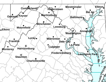
A WINTER STORM WARNING remains in effect until 11PM Tuesday night. A WIND CHILL WARNING begins at 6PM Tuesday evening until noon Wednesday. Click image for latest updates in addition to text below.
URGENT – WINTER WEATHER MESSAGE
NATIONAL WEATHER SERVICE BALTIMORE MD/WASHINGTON DC
954 AM EST WED JAN 22 2014
DCZ001-MDZ003>007-009>011-013-014-016>018-VAZ025>031-036>040-042-
050>057-501-502-WVZ051>053-221700-
/O.CON.KLWX.WC.Y.0005.000000T0000Z-140122T1700Z/
DISTRICT OF COLUMBIA-WASHINGTON-FREDERICK MD-CARROLL-
NORTHERN BALTIMORE-HARFORD-MONTGOMERY-HOWARD-SOUTHERN BALTIMORE-
PRINCE GEORGES-ANNE ARUNDEL-CHARLES-ST. MARYS-CALVERT-AUGUSTA-
ROCKINGHAM-SHENANDOAH-FREDERICK VA-PAGE-WARREN-CLARKE-NELSON-
ALBEMARLE-GREENE-MADISON-RAPPAHANNOCK-LOUDOUN-ORANGE-CULPEPER-
PRINCE WILLIAM/MANASSAS/MANASSAS PARK-FAIRFAX-
ARLINGTON/FALLS CHURCH/ALEXANDRIA-STAFFORD-SPOTSYLVANIA-
KING GEORGE-NORTHERN FAUQUIER-SOUTHERN FAUQUIER-MORGAN-BERKELEY-
JEFFERSON-
INCLUDING THE CITIES OF…WASHINGTON…HAGERSTOWN…FREDERICK…
WESTMINSTER…GAITHERSBURG…COLUMBIA…BALTIMORE…ANNAPOLIS…
WALDORF…ST MARYS CITY…STAUNTON…WAYNESBORO…HARRISONBURG…
WINCHESTER…FRONT ROYAL…CHARLOTTESVILLE…LEESBURG…
CULPEPER…MANASSAS…MANASSAS PARK…FAIRFAX…ALEXANDRIA…
FALLS CHURCH…FREDERICKSBURG…WARRENTON…MARTINSBURG…
CHARLES TOWN
954 AM EST WED JAN 22 2014
…WIND CHILL ADVISORY REMAINS IN EFFECT UNTIL NOON EST TODAY…
* WIND CHILL…5 TO 15 DEGREES BELOW ZERO THROUGH NOON.
* TEMPERATURES…HIGHS WILL BE IN THE TEENS.
* WINDS…NORTHWEST 15 TO 25 MPH WITH GUSTS UP TO 40 MPH.
* IMPACTS…DANGEROUSLY LOW WIND CHILLS MAY LEAD TO HYPOTHERMIA
OR FROST BITE ON EXPOSED SKIN.
PRECAUTIONARY/PREPAREDNESS ACTIONS…
A WIND CHILL ADVISORY MEANS THAT VERY COLD AIR AND STRONG WINDS
WILL COMBINE TO GENERATE LOW WIND CHILLS. THIS WILL RESULT IN
FROST BITE AND LEAD TO HYPOTHERMIA IF PRECAUTIONS ARE NOT TAKEN.
IF YOU MUST VENTURE OUTDOORS…MAKE SURE YOU WEAR A HAT AND
GLOVES.
The previously issued Winter Storm Watch has now been upgraded to a Winter Storm Warning. Effective from early Tuesday until Tuesday night.
WINTER STORM WARNING IN EFFECT FROM 4 AM TO 11 PM EST TUESDAY
URGENT – WINTER WEATHER MESSAGE
NATIONAL WEATHER SERVICE BALTIMORE MD/WASHINGTON DC
723 PM EST MON JAN 20 2014
CHARLES-ST. MARYS-CALVERT-NELSON-ALBEMARLE-GREENE-MADISON-ORANGE-
STAFFORD-SPOTSYLVANIA-KING GEORGE-
INCLUDING THE CITIES OF…WALDORF…ST MARYS CITY…
CHARLOTTESVILLE…FREDERICKSBURG
723 PM EST MON JAN 20 2014
…WINTER STORM WARNING REMAINS IN EFFECT FROM 7 AM TO 11 PM EST
TUESDAY…
* PRECIPITATION TYPE…SNOW.
* ACCUMULATIONS…4 TO 6 INCHES.
* TIMING…SNOW WILL DEVELOP BETWEEN 7 AM AND 10 AM TUESDAY
MORNING. THE HEAVIEST SNOW IS EXPECTED DURING THE MIDDAY AND
AFTERNOON HOURS. SNOW WILL TAPER OFF TUESDAY EVENING.
* TEMPERATURES…IN THE 20S WHEN SNOW BEGINS TUESDAY
MORNING…THEN FALLING INTO THE TEENS TUESDAY AFTERNOON AND
EVENING. WIND CHILL VALUES WILL BE AROUND ZERO TUESDAY
AFTERNOON…FALLING TO AROUND 10 BELOW ZERO TUESDAY EVENING.
* WINDS…NORTHEAST 5 TO 10 MPH…INCREASING TO 10 TO 20 MPH WITH
GUSTS AROUND 30 MPH TUESDAY AFTERNOON AND EVENING.
* IMPACTS…ROADS WILL BE SNOW COVERED AND SLIPPERY. THE
COMBINATION OF SNOW AND BLOWING SNOW WILL REDUCE VISIBILITY TO
BELOW ONE-HALF MILE AT TIMES. TRAVELING WILL BECOME DANGEROUS
TUESDAY. THE MORNING COMMUTE MAY BE IMPACTED BY THE SNOW…AND
SIGNIFICANT IMPACT IS EXPECTED FOR THE AFTERNOON AND EVENING
COMMUTE.
PRECAUTIONARY/PREPAREDNESS ACTIONS…
A WINTER STORM WARNING FOR HEAVY SNOW MEANS SEVERE WINTER WEATHER
CONDITIONS ARE EXPECTED OR OCCURRING. SIGNIFICANT AMOUNTS OF
SNOW ARE FORECAST THAT WILL MAKE TRAVEL DANGEROUS. ONLY TRAVEL IN
AN EMERGENCY. IF YOU MUST TRAVEL…KEEP AN EXTRA FLASHLIGHT…
FOOD…AND WATER IN YOUR VEHICLE IN CASE OF AN EMERGENCY.
URGENT – WINTER WEATHER MESSAGE
NATIONAL WEATHER SERVICE BALTIMORE MD/WASHINGTON DC
723 PM EST MON JAN 20 2014
WASHINGTON-EXTREME WESTERN ALLEGANY-CENTRAL AND EASTERN ALLEGANY-
AUGUSTA-ROCKINGHAM-SHENANDOAH-FREDERICK VA-PAGE-WARREN-CLARKE-
WESTERN HIGHLAND-EASTERN HIGHLAND-HAMPSHIRE-MORGAN-BERKELEY-
JEFFERSON-HARDY-WESTERN GRANT-EASTERN GRANT-WESTERN MINERAL-
EASTERN MINERAL-WESTERN PENDLETON-EASTERN PENDLETON-
INCLUDING THE CITIES OF…HAGERSTOWN…FROSTBURG…CUMBERLAND…
STAUNTON…WAYNESBORO…HARRISONBURG…WINCHESTER…FRONT ROYAL…
HIGHTOWN…MONTEREY…MARTINSBURG…CHARLES TOWN…MOOREFIELD…
BAYARD…MOUNT STORM…PETERSBURG…ELK GARDEN…KEYSER…
FORT ASHBY…CIRCLEVILLE…FRANKLIN
723 PM EST MON JAN 20 2014
…WINTER STORM WARNING REMAINS IN EFFECT FROM 4 AM TO 11 PM EST
TUESDAY…
* PRECIPITATION TYPE…SNOW.
* ACCUMULATIONS…6 TO 8 INCHES WITH HIGHER AMOUNTS OF 8 TO 10
INCHES ACROSS THE HIGHER ELEVATIONS OF THE POTOMAC HIGHLANDS.
* TIMING…SNOW WILL DEVELOP BETWEEN 4 AM AND 7 AM EARLY TUESDAY
MORNING. THE HEAVIEST SNOW IS EXPECTED TUESDAY MORNING THROUGH
EARLY AFTERNOON. SNOW WILL TAPER OFF IN THE EARLY EVENING.
* TEMPERATURES…IN THE 20S WHEN SNOW BEGINS EARLY TUESDAY
MORNING…THEN FALLING INTO THE SINGLE DIGITS IN THE MOUNTAINS
AND INTO THE TEENS ELSEWHERE DURING THE AFTERNOON AND EVENING.
WIND CHILL VALUES WILL BE AROUND ZERO TUESDAY
AFTERNOON…DROPPING TO AROUND MINUS 15 TUESDAY EVENING.
* WINDS…NORTHEAST 5 TO 10 MPH…INCREASING TO 10 TO 20 MPH WITH
GUSTS AROUND 30 MPH TUESDAY AFTERNOON AND EVENING.
* IMPACTS…ROADS WILL BE SNOW COVERED AND SLIPPERY. THE
COMBINATION OF SNOW AND BLOWING SNOW WILL REDUCE VISIBILITY TO
BELOW ONE-HALF MILE AT TIMES. TRAVELING WILL BECOME DANGEROUS
TUESDAY. BOTH THE MORNING AND AFTERNOON COMMUTE WILL LIKELY BE
IMPACTED BY THE SNOW.
PRECAUTIONARY/PREPAREDNESS ACTIONS…
A WINTER STORM WARNING FOR HEAVY SNOW MEANS SEVERE WINTER WEATHER
CONDITIONS ARE EXPECTED OR OCCURRING. SIGNIFICANT AMOUNTS OF
SNOW ARE FORECAST THAT WILL MAKE TRAVEL DANGEROUS. ONLY TRAVEL IN
AN EMERGENCY. IF YOU MUST TRAVEL…KEEP AN EXTRA FLASHLIGHT…
FOOD…AND WATER IN YOUR VEHICLE IN CASE OF AN EMERGENCY.
URGENT – WINTER WEATHER MESSAGE
NATIONAL WEATHER SERVICE BLACKSBURG VA
221 PM EST MON JAN 20 2014
…HEAVY SNOW POSSIBLE TUESDAY…
.AN ALBERTA CLIPPER IS EXPECTED TO MOVE RAPIDLY SOUTHEAST…
CROSSING THE OHIO VALLEY TONIGHT…THEN STRENGTHEN AS IT SPARKS
THE DEVELOPMENT OF A WINTER STORM ALONG THE MID ATLANTIC COAST ON
TUESDAY. THIS STORM WILL RESULT IN A 6-12 HOUR PERIOD OF SNOW
BEGINNING TUESDAY MORNING…WITH THE HEAVIEST OF THE SNOW FALLING
OVER CENTRAL AND NORTHERN VIRGINIA.
TAZEWELL-SMYTH-BLAND-GILES-WYTHE-PULASKI-MONTGOMERY-FLOYD-CRAIG-
ROANOKE-BOTETOURT-ROCKBRIDGE-FRANKLIN-BEDFORD-AMHERST-CAMPBELL-
APPOMATTOX-BUCKINGHAM-
INCLUDING THE CITIES OF…TAZEWELL…MARION…BLAND…
PEARISBURG…WYTHEVILLE…RADFORD…PULASKI…BLACKSBURG…
FLOYD…NEW CASTLE…ROANOKE…SALEM…FINCASTLE…LEXINGTON…
BUENA VISTA…ROCKY MOUNT…BEDFORD…AMHERST…LYNCHBURG…
APPOMATTOX
221 PM EST MON JAN 20 2014
…WINTER STORM WARNING IN EFFECT FROM 4 AM TO 10 PM EST
TUESDAY…
THE NATIONAL WEATHER SERVICE IN BLACKSBURG HAS ISSUED A WINTER
STORM WARNING FOR SNOW…WHICH IS IN EFFECT FROM 4 AM TO 10 PM
EST TUESDAY. THE WINTER STORM WATCH IS NO LONGER IN EFFECT.
* LOCATIONS…THE MOUNTAIN EMPIRE…NEW RIVER AND ROANOKE VALLEYS
TO THE HILL CITY OF LYNCHBURG.
* HAZARD TYPES…SNOW.
* ACCUMULATIONS…SNOW ACCUMULATION OF 4 TO 6 INCHES NORTH OF HWY
460…2 TO 5 INCHES SOUTH.
* TIMING…BEGINNING TUESDAY AROUND MORNING RUSH HOUR…ENDING BY
EVENING RUSH HOUR.
* IMPACTS…ROADS WILL BECOME SNOW COVERED. SNOW WILL LIKELY
IMPACT BOTH THE MORNING AND EVENING WORK COMMUTE.
* WINDS…NORTH 10 TO 20 MPH WITH GUSTS UP TO 30 MPH.
* TEMPERATURES…FALLING INTO THE MID 20S.
PRECAUTIONARY/PREPAREDNESS ACTIONS…
THIS WINTER STORM WATCH MEANS THERE IS A POTENTIAL FOR
SIGNIFICANT SNOW ACCUMULATION THAT MAY IMPACT TRAVEL. CONTINUE TO
MONITOR THE LATEST FORECASTS.
A WINTER STORM WARNING FOR HEAVY SNOW MEANS SEVERE WINTER WEATHER
CONDITIONS ARE EXPECTED OR OCCURRING. SIGNIFICANT AMOUNTS OF SNOW
ARE FORECAST THAT WILL MAKE TRAVEL DANGEROUS. ONLY TRAVEL IN AN
EMERGENCY. IF YOU MUST TRAVEL…KEEP AN EXTRA FLASHLIGHT…FOOD…
AND WATER IN YOUR VEHICLE IN CASE OF AN EMERGENCY.
Graphic courtesy of CBS-19 The Newsplex in Charlottesville. – Chief Meteorologist Travis Koshko over at our media partners from CBS-19 prepared this graphic to show estimated snowfall across the area during the Monday night / Tuesday event.
Central Virginia Blue Ridge
As we indicated in an earlier Winter Storm Watch issued here, the chance for accumulating snow is becoming likely across much of Virginia, including the eastern. A fast moving cold front will be moving across the area tonight into Tuesday, meanwhile a rather strong low pressure area is developing as well which should enhance the chances for significant snow, sometimes heavy – Tuesday morning into early afternoon. I had already mentioned the potential for snow, but this increases the likelihood of seeing some decent accumulations across the area. Our media partners over at CBS-19 prepared the map above to give estimates of what we can expect.
Much of the state of Virginia is under a Winter Storm Watch beginning late Monday night into Tuesday evening. Heavy Snow possible. Click on map above for the latest updates.
WINTER STORM WATCH IN EFFECT FROM LATE TONIGHT THROUGH TUESDAY EVENING
URGENT – WINTER WEATHER MESSAGE
NATIONAL WEATHER SERVICE BALTIMORE MD/WASHINGTON DC
1048 AM EST MON JAN 20 2014
WASHINGTON-EXTREME WESTERN ALLEGANY-CENTRAL AND EASTERN ALLEGANY-
AUGUSTA-ROCKINGHAM-SHENANDOAH-FREDERICK VA-PAGE-WARREN-CLARKE-
NELSON-ALBEMARLE-GREENE-MADISON-RAPPAHANNOCK-ORANGE-CULPEPER-
SPOTSYLVANIA-WESTERN HIGHLAND-EASTERN HIGHLAND-HAMPSHIRE-MORGAN-
BERKELEY-JEFFERSON-HARDY-WESTERN GRANT-EASTERN GRANT-
WESTERN MINERAL-EASTERN MINERAL-WESTERN PENDLETON-
EASTERN PENDLETON-
INCLUDING THE CITIES OF…HAGERSTOWN…FROSTBURG…CUMBERLAND…
STAUNTON…WAYNESBORO…HARRISONBURG…WINCHESTER…FRONT ROYAL…
CHARLOTTESVILLE…WASHINGTON…CULPEPER…FREDERICKSBURG…
HIGHTOWN…MONTEREY…MARTINSBURG…CHARLES TOWN…MOOREFIELD…
BAYARD…MOUNT STORM…PETERSBURG…ELK GARDEN…KEYSER…
FORT ASHBY…CIRCLEVILLE…FRANKLIN
1048 AM EST MON JAN 20 2014
…WINTER STORM WATCH REMAINS IN EFFECT FROM LATE TONIGHT THROUGH
TUESDAY EVENING…
* PRECIPITATION TYPE…SNOW
* ACCUMULATIONS…POTENTIAL FOR FIVE INCHES OR MORE.
* TIMING…LATE TONIGHT THROUGH TUESDAY EVENING. THE HEAVIEST
SNOW WILL BE TUESDAY MORNING THROUGH MIDDAY.
* TEMPERATURES…DROPPING INTO THE SINGLE DIGITS IN THE MOUNTAINS
AND INTO THE TEENS ELSEWHERE. WIND CHILL VALUES WILL BE AROUND
ZERO TUESDAY AFTERNOON DROPPING TO MINUS 15 TUESDAY NIGHT.
* WINDS…BECOMING NORTH 10 TO 15 MPH WITH GUSTS AROUND 25 MPH
TUESDAY AFTERNOON AND EVENING.
* IMPACTS…ROADS WILL BE SNOW COVERED AND SLIPPERY. THE
COMBINATION OF SNOW AND BLOWING SNOW WILL REDUCE VISIBILITY TO
BELOW ONE-HALF MILE AT TIMES. TRAVELING MAY BE DANGEROUS
TUESDAY. THE MORNING AND EVENING COMMUTE MAY BE IMPACTED BY
THE SNOW.
PRECAUTIONARY/PREPAREDNESS ACTIONS…
A WINTER STORM WATCH MEANS THERE IS A POTENTIAL FOR SIGNIFICANT
SNOW ACCUMULATIONS THAT MAY IMPACT TRAVEL. CONTINUE TO MONITOR
THE LATEST FORECASTS.
URGENT – WINTER WEATHER MESSAGE
NATIONAL WEATHER SERVICE BLACKSBURG VA
935 AM EST MON JAN 20 2014
…HEAVY SNOW POSSIBLE TUESDAY…
.AN ALBERTA CLIPPER IS EXPECTED TO MOVE RAPIDLY SOUTHEAST…
CROSSING THE OHIO VALLEY TONIGHT…THEN STRENGTHEN AS IT SPARKS
THE DEVELOPMENT OF A WINTER STORM ALONG THE MID ATLANTIC COAST ON
TUESDAY. THIS STORM WILL RESULT IN A 6-12 HOUR PERIOD OF SNOW
BEGINNING TUESDAY MORNING…WITH THE HEAVIEST OF THE SNOW FALLING
OVER CENTRAL AND NORTHERN VIRGINIA.
TAZEWELL-SMYTH-BLAND-GILES-WYTHE-PULASKI-MONTGOMERY-FLOYD-CRAIG-
ALLEGHANY VA-BATH-ROANOKE-BOTETOURT-ROCKBRIDGE-FRANKLIN-BEDFORD-
AMHERST-CAMPBELL-APPOMATTOX-BUCKINGHAM-MERCER-SUMMERS-MONROE-
GREENBRIER-
INCLUDING THE CITIES OF…TAZEWELL…MARION…BLAND…
PEARISBURG…WYTHEVILLE…RADFORD…PULASKI…BLACKSBURG…
FLOYD…NEW CASTLE…CLIFTON FORGE…COVINGTON…HOT SPRINGS…
ROANOKE…SALEM…FINCASTLE…LEXINGTON…BUENA VISTA…
ROCKY MOUNT…BEDFORD…AMHERST…LYNCHBURG…APPOMATTOX…
BLUEFIELD…HINTON…HIX…UNION…LEWISBURG…QUINWOOD…DUO…
RAINELLE
935 AM EST MON JAN 20 2014
…WINTER STORM WATCH REMAINS IN EFFECT FROM LATE TONIGHT THROUGH
TUESDAY EVENING…
* LOCATIONS…MAINLY ALONG AND NORTH OF HIGHWAY 460.
* HAZARD TYPES…SNOW.
* ACCUMULATIONS…SNOW ACCUMULATION OF 3 TO 6 INCHES.
* TIMING…BEGINNING WEST OF THE BLUE RIDGE AROUND 4:00 AM
TUESDAY. BEGINNING EAST OF THE BLUE RIDGE AROUND DAYBREAK.
* IMPACTS…ROADS WILL BECOME SNOW COVERED. SNOW WILL LIKELY
IMPACT BOTH THE MORNING AND EVENING WORK COMMUTE.
* WINDS…NORTH 5 TO 15 MPH WITH GUSTS UP TO 25 MPH.
* TEMPERATURES…FALLING INTO THE MID 20S.
PRECAUTIONARY/PREPAREDNESS ACTIONS…
THIS WINTER STORM WATCH MEANS THERE IS A POTENTIAL FOR
SIGNIFICANT SNOW ACCUMULATION THAT MAY IMPACT TRAVEL. CONTINUE TO
MONITOR THE LATEST FORECASTS.
Wintergreen
Nelson County, VA
Most of the time on a beautiful, sunny holiday weekend not much can go wrong. But every once in awhile it can. Enter Wintergreen Fire & Rescue. “Either her pulley truck faulted, or she just didn’t weigh enough to make it to the end. The result is, she finds the center. Our guys rig on the same line and either pick off of the line, or correct and continue. That’s what happened today Saturday. Our team practices this scenario.” Chief Curtis Sheets of Wintergreen Fire & Rescue told us by phone. BRL got a few messages asking if we knew what was going on.
No one was hurt and the delay was pretty short, but it gave the rescue crews a chance to do the real thing after all of the practice scenarios they go through each year.