

Caution Urged For Propane Users Of Furnaces With Exhaust Vents : Be Sure Deep Snow Is Cleared


Lovingston
Nelson County, VA
With the exceptionally high snowfall rates we’ve experienced lately along with winds sometimes exceeding 67MPH gusts in the mountains, people who own propane furnaces that use an exhaust pipe located near the ground are urged to inspect and make sure drifting snow has not blocked the pipe. “We are approaching snowfall amounts and wind drifts – enough to possibly block exhaust vents and potentially push CO (carbon monoxide) back into structures,” said Tim Spicer, VP of operations for Foster Fuels based in Lovingston.
Tips mentioned include:
-Keep snow and ice from accumulating
on propane equipment.-Snow or ice accumulation can potentially cause
parts of your propane system to crack or break, resulting
in a gas leak. It is your responsibility to make sure that
all propane pipes, valves, regulators, and tanks are
clear of snow and ice.-Gently brush away snow or ice
that has accumulated around the tank, meter, regulator,
and any other piping. Do this using a broom or by
hand. If you must use a shovel, use extreme caution
around all equipment.-If you notice any snow or ice
buildup that cannot be removed easily, contact your
propane retailer immediately. DO NOT attempt to
remove snow or ice by kicking or hitting equipment.-Be alert to snow buildup
on rooftops and other areas.-Frequently check where snow or ice collect on your
roof, structure, or nearby trees and clear it if you
believe it might fall on any part of your propane
system. Never shovel snow off roofs and onto propane
equipment.-Heavy accumulations of snow or ice falling
on tanks, regulators, meters, piping, or valves may
cause damage that could result in a gas leak.
In high snowfall areas, drifting snow and snow and ice
sliding off the roof may require additional regulator and
vent protection.-Consider installing snow protection
or a “snow shelter” above your meter or regulator to
prevent snow and ice damage. Contact your propane
retailer for more information.-Keep vents clear.
Appliance vents and chimney flues must ALWAYS be
clear of snow or ice. Some homes may have “direct”
vents, which are close to the ground. Improper venting
can cause carbon monoxide to become trapped in
your home, causing serious illness or even death.

Ralph Waite, Actor Who Played The Father On The Waltons Dies at 85

Major Snow Falls Across Central Virginia Blue Ridge

Central Virginia Blue Ridge
Nelson County, VA
As predicted a major winter storm hit the Central Virginia Blue Ridge overnight Wednesday into Thursday. Here at our BRL offices we received about a foot of snow. We’re about 3 miles north of Nellysford in Nelson County, VA.
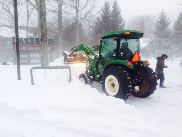


Light, sometimes moderate snow, will continued through the early afternoon. Believe it or not, this time next week we’ll be in the mid and upper 50’s!
Winter Storm Warnings – CANCELED

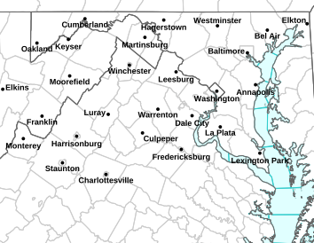
Winter Weather Statement
Statement as of 7:06 PM EST on February 13, 2014
…Winter Storm Warning is cancelled…
The National Weather Service in Baltimore MD/Washington has
cancelled the Winter Storm Warning.
Accumulating snow has ended across the area therefore the Winter
Storm Warning has been cancelled.
WINTER STORM WARNING REMAINS IN EFFECT UNTIL 9 PM EST THIS EVENING
URGENT – WINTER WEATHER MESSAGE
NATIONAL WEATHER SERVICE BALTIMORE MD/WASHINGTON DC
1120 AM EST THU FEB 13 2014
AUGUSTA-ROCKINGHAM-SHENANDOAH-PAGE-NELSON-ALBEMARLE-GREENE-
MADISON-RAPPAHANNOCK-ORANGE-CULPEPER-SPOTSYLVANIA-
WESTERN HIGHLAND-EASTERN HIGHLAND-WESTERN PENDLETON-
EASTERN PENDLETON-
INCLUDING THE CITIES OF…STAUNTON…WAYNESBORO…HARRISONBURG…
CHARLOTTESVILLE…WASHINGTON…CULPEPER…FREDERICKSBURG…
HIGHTOWN…MONTEREY…CIRCLEVILLE…FRANKLIN
1120 AM EST THU FEB 13 2014
…WINTER STORM WARNING REMAINS IN EFFECT UNTIL 9 PM EST THIS
EVENING…
* PRECIPITATION TYPE…HEAVY SNOW AND LIGHT FREEZING RAIN OR
FREEZING DRIZZLE.
* ACCUMULATIONS…LESS THAN ONE-TENTH INCH OF ICE. AN ADDITIONAL
1 TO 3 INCHES THROUGH THIS EVENING. STORM-TOTAL SNOWFALL OF 14
TO 24 INCHES…WITH THE HIGHEST AMOUNTS ALONG THE BLUE RIDGE.
* TIMING…A MIX OF LIGHT SNOW…SLEET AND FREEZING RAIN OR
FREEZING DRIZZLE WILL CONTINUE THROUGH EARLY THIS AFTERNOON.
STEADIER SNOW IS EXPECTED TO REDEVELOP LATE THIS
AFTERNOON AND THIS EVENING. A BURST OF MODERATE SNOW IS
EXPECTED DURING THIS TIME.
* TEMPERATURES…SLOWLY RISING INTO THE LOWER 30S.
* WINDS…NORTH 10 TO 20 MPH WITH GUSTS TO 30 MPH.
* IMPACTS…ROADS WILL BE SNOW COVERED AND SLIPPERY. TRAVEL WILL
BE EXTREMELY DANGEROUS. HEAVY WET SNOW WILL LEAD TO POWER
OUTAGES.
PRECAUTIONARY/PREPAREDNESS ACTIONS…
SEVERE WINTER WEATHER CONDITIONS ARE OCCURRING. SIGNIFICANT
AMOUNTS OF SNOW ARE FORECAST THAT WILL MAKE TRAVEL DANGEROUS.
ONLY TRAVEL IN AN EMERGENCY. IF YOU MUST TRAVEL…KEEP AN EXTRA
FLASHLIGHT… FOOD…AND WATER IN YOUR VEHICLE IN CASE OF AN
EMERGENCY.
URGENT – WINTER WEATHER MESSAGE
NATIONAL WEATHER SERVICE BLACKSBURG VA
1019 AM EST THU FEB 13 2014
…WINTER STORM WILL LINGER OVER THE AREA TODAY…
.LOW PRESSURE CENTERED NEAR THE MID ATLANTIC COAST WILL MOVE
NORTHEAST AND INTENSIFY AS IT APPROACHES NEW ENGLAND TONIGHT.
SNOW WILL LINGER OVER THE AREA TODAY…POSSIBLY MIXED WITH SLEET
OR FREEZING DRIZZLE AT TIMES. ALL OF THE PRECIPITATION WILL COME
TO AN END BY THIS EVENING. THE HEAVIEST SNOWFALL FROM THIS STORM
WILL BE NEAR THE BLUE RIDGE WHERE STORM TOTALS WILL BE IN THE
14 TO 18 INCH RANGE.
ASHE-ALLEGHANY NC-SURRY-WATAUGA-WILKES-YADKIN-SMYTH-BLAND-GILES-
WYTHE-PULASKI-MONTGOMERY-GRAYSON-CARROLL-FLOYD-CRAIG-ALLEGHANY VA-
BATH-ROANOKE-BOTETOURT-ROCKBRIDGE-PATRICK-FRANKLIN-BEDFORD-
AMHERST-CAMPBELL-APPOMATTOX-BUCKINGHAM-
INCLUDING THE CITIES OF…WEST JEFFERSON…SPARTA…DOBSON…
BOONE…WILKESBORO…YADKINVILLE…MARION…BLAND…PEARISBURG…
WYTHEVILLE…RADFORD…PULASKI…BLACKSBURG…INDEPENDENCE…
WHITETOP…TROUTDALE…VOLNEY…GALAX…FLOYD…NEW CASTLE…
CLIFTON FORGE…COVINGTON…HOT SPRINGS…ROANOKE…SALEM…
FINCASTLE…LEXINGTON…BUENA VISTA…STUART…ROCKY MOUNT…
BEDFORD…AMHERST…LYNCHBURG…APPOMATTOX
1019 AM EST THU FEB 13 2014
…WINTER STORM WARNING NOW IN EFFECT UNTIL 7 PM EST THIS
EVENING…
* LOCATIONS…MOUNTAINS AND FOOTHILLS OF SOUTHWEST VIRGINIA AND
NORTH CAROLINA.
* TIMING…THROUGH THIS AFTERNOON.
* HAZARDS…SNOW. BLOWING AND DRIFTING SNOW THIS AFTERNOON AND
TONIGHT.
* ACCUMULATIONS…ADDITIONAL SNOW ACCUMULATION OF 2 TO 4 INCHES…WITH
SNOW TOTALS GENERALLY RANGING FROM 10 TO 16 INCHES. AMOUNTS NEAR
THE BLUE RIDGE OF VIRGINIA MAY TOTAL BETWEEN 14 AND 18 INCHES.
* MAIN IMPACTS…SNOW COVERED ROADS. TRAVEL IS DISCOURAGED UNTIL
ROADS ARE CLEARED.
PRECAUTIONARY/PREPAREDNESS ACTIONS…
A WINTER STORM WARNING FOR HEAVY SNOW MEANS SEVERE WINTER WEATHER
CONDITIONS ARE EXPECTED OR OCCURRING. SIGNIFICANT AMOUNTS OF SNOW
ARE FORECAST THAT WILL MAKE TRAVEL DANGEROUS. ONLY TRAVEL IN AN
EMERGENCY. IF YOU MUST TRAVEL…KEEP AN EXTRA FLASHLIGHT…FOOD…
AND WATER IN YOUR VEHICLE IN CASE OF AN EMERGENCY.
THE PUBLIC IS ENCOURAGED TO REPORT SNOWFALL AMOUNTS…ICE
ACCUMULATION OR WIND DAMAGE TO THE NATIONAL WEATHER SERVICE VIA
EMAIL AT RNK.SKYWARN@NOAA.GOV OR AT PHONE NUMBER 1…8 6 6…
2 1 5…4 3 2 4.

Central Virginia Electric Prepares for Winter Snow Storm

Lovingston
Nelson County, VA
Release Via CVEC Tuesday afternoon 2.11.14
As the now named winter storm “Pax” approaches central Virginia, CVEC is prepared to respond to power outages caused by snow and winter winds. Below is an advisory issued by CVEC:
With the forecasted arrival of significant snowfall in Virginia, Central Virginia Electric Cooperative (CVEC) is preparing to respond to outages due to likely snow loading on trees growing outside of the 40-foot right surrounding the CVEC distribution lines.
Field crews and equipment are ready to go if necessary. Dispatchers and field supervisors are prepared to coordinate power restoration efforts. Member service representatives are available to answer member calls and enter outage tickets. Crews from sister electric cooperatives have been recruited and will travel to CVEC to provide assistance with outage restoration.
CVEC members may report outages by calling 800-367-2832 and using the automated reporting system. Cooperative members may also visit http://www.mycvec.com on a computer or a smart phone to report an outage online. Each reported loss of power will be entered into the CVEC Outage Management System, where it will be combined with other reported outages to allow dispatchers to identify fault locations and to send crews to where they will do the most good.
Outage updates will be available through the local media, on the CVEC Facebook page, via Twitter and http://www.mycvec.com. The Cooperative website also features an outage map with the number of members affected within each substation service area.
Co-op members are advised to take appropriate measures that include preparing for an outage and creating an outage kit. CVEC also requests that members turn off major appliances after a loss of power, in order to help with cold load pick up…the point when power is restored and there is a major burden on the distribution system.
For safety sake, anyone that encounters a down-power line, stay clear, even if there is no obvious sparking. Do not attempt to cut trees on power lines. The tree may be conducting electricity. In addition, once cut, the power line may launch the tree in any direction. Please leave restoration work for the trained linemen.
If the storm does result in significant power outages, CVEC crews will begin repairs along major lines closest to the local substation, then work their way out along the primary lines, clearing outages as they go in order to restore service to as many members as soon as possible and to permit power to flow to the end of the distribution lines. Other personnel will be creating damage assessments, while other crews may be dedicated to service restoration in local neighborhoods or in clusters of home.
Significant Winter Storm Becoming More Certain For Central Virginia Blue Ridge : With Audio

Central Virginia Blue Ridge
A WINTER STORM WATCH continues beginning Wednesday afternoon through Thursday afternoon. Details here.

WINTER STORM WATCH / WARNINGS: Replaced

This set of watches / warnings has been replaced with a new WINTER STORM WARNING here.
WINTER STORM WATCH
URGENT – WINTER WEATHER MESSAGE
NATIONAL WEATHER SERVICE BALTIMORE MD/WASHINGTON DC
1206 PM EST TUE FEB 11 2014
AUGUSTA-ROCKINGHAM-NELSON-ALBEMARLE-GREENE-ORANGE-
WESTERN HIGHLAND-EASTERN HIGHLAND-WESTERN PENDLETON-
EASTERN PENDLETON-
INCLUDING THE CITIES OF…STAUNTON…WAYNESBORO…HARRISONBURG…
CHARLOTTESVILLE…HIGHTOWN…MONTEREY…CIRCLEVILLE…FRANKLIN
1206 PM EST TUE FEB 11 2014
…WINTER STORM WATCH REMAINS IN EFFECT FROM WEDNESDAY AFTERNOON
THROUGH THURSDAY AFTERNOON…
* PRECIPITATION TYPE…SNOW
* ACCUMULATIONS…THE POTENTIAL FOR 5 OR MORE INCHES OF SNOW.
* TIMING…SNOW IS EXPECTED TO MOVE IN FROM THE SOUTH LATE
WEDNESDAY AFTERNOON AND EVENING. SNOW COULD BE HEAVY AT TIMES
WEDNESDAY NIGHT AND THURSDAY.
* TEMPERATURES…IN THE TEENS AND 20S WEDNESDAY AFTERNOON AND
NIGHT… SLOWLY RISING INTO THE LOWER 30S THURSDAY AFTERNOON.
* WINDS…BECOMING NORTH 5 TO 15 MPH WITH GUSTS UP TO 20 MPH.
* IMPACTS…ROADS MAY BECOME SNOW COVERED AND SLIPPERY. TRAVEL
MAY BE DANGEROUS WEDNESDAY NIGHT AND THURSDAY. HEAVY WET SNOW
COULD LEAD TO SOME POWER OUTAGES.
PRECAUTIONARY/PREPAREDNESS ACTIONS…
A WINTER STORM WATCH MEANS THERE IS A POTENTIAL FOR SIGNIFICANT
SNOW ACCUMULATIONS THAT MAY IMPACT TRAVEL. CONTINUE TO MONITOR
THE LATEST FORECASTS.
WINTER STORM WARNING IN EFFECT FROM 1 PM WEDNESDAY TO 6 PM EST THURSDAY
URGENT – WINTER WEATHER MESSAGE
NATIONAL WEATHER SERVICE BLACKSBURG VA
205 PM EST TUE FEB 11 2014
…HEAVY SNOW EXPECTED WEDNESDAY INTO EARLY THURSDAY…
.A LOW PRESSURE CENTER WILL MOVE NORTHEAST AND INTENSIFY ALONG
THE EAST COAST WEDNESDAY INTO THURSDAY. THIS WILL PUSH MOISTURE
NORTHWARD ALONG THE ATLANTIC SEABOARD. COLD AIR ALREADY IN PLACE
DURING THAT TIME WILL CAUSE THIS PRECIPITATION TO FALL MAINLY AS
SNOW…WITH A FEW HOURS OF SLEET POSSIBLE EAST OF DANVILLE VA.
STRONG UPSLOPE FLOW INTO THE MOUNTAINS…IN ADDITION TO THE
POTENTIAL FOR HEAVY SNOW BANDS TO DEVELOP ACROSS THE AREA…WILL
LEAD TO THE POTENTIAL FOR 6 TO 10 INCH SNOWFALL ACCUMULATIONS
ACROSS THE MOUNTAINS TO THE BLUE RIDGE…AND 10 TO 14 INCHES
ACROSS THE PIEDMONT. LOCALLY HIGHER AMOUNTS MAY BE POSSIBLE.
GILES-CRAIG-ALLEGHANY VA-BATH-ROANOKE-BOTETOURT-ROCKBRIDGE-
BEDFORD-AMHERST-CAMPBELL-APPOMATTOX-BUCKINGHAM-CHARLOTTE-MERCER-
SUMMERS-MONROE-GREENBRIER-
INCLUDING THE CITIES OF…PEARISBURG…NEW CASTLE…
CLIFTON FORGE…COVINGTON…HOT SPRINGS…ROANOKE…SALEM…
FINCASTLE…LEXINGTON…BUENA VISTA…BEDFORD…AMHERST…
LYNCHBURG…APPOMATTOX…KEYSVILLE…BLUEFIELD…HINTON…HIX…
UNION…LEWISBURG…QUINWOOD…DUO…RAINELLE
205 PM EST TUE FEB 11 2014
…WINTER STORM WARNING IN EFFECT FROM 1 PM WEDNESDAY TO 6 PM EST
THURSDAY…
THE NATIONAL WEATHER SERVICE IN BLACKSBURG HAS ISSUED A WINTER
STORM WARNING FOR SNOW…WHICH IS IN EFFECT FROM 1 PM WEDNESDAY
TO 6 PM EST THURSDAY. THE WINTER STORM WATCH IS NO LONGER IN
EFFECT.
* LOCATIONS…AREAS OF VIRGINIA AND SOUTHEAST WEST VIRGINIA
NORTH OF HIGHWAY 460.
* TIMING…EARLY WEDNESDAY AFTERNOON THROUGH THURSDAY EVENING.
* WINDS…NORTH 5 TO 10 MPH WITH GUSTS UP TO 20 MPH.
* TEMPERATURES…IN THE MID 20S.
* HAZARDS…HEAVY SNOW.
* ACCUMULATIONS…SNOW ACCUMULATIONS OF 6 TO 10 INCHES ARE
POSSIBLE WEST OF THE BLUE RIDGE…WITH 10 TO 14 INCHES POSSIBLE
FURTHER EAST ACROSS THE PIEDMONT. LOCALLY HIGHER AMOUNTS ARE
POSSIBLE.
* MAIN IMPACTS…HEAVY SNOW CAN LEAD TO SLICK AND HAZARDOUS
TRAVEL CONDITIONS AS SNOWFALL ACCUMULATES ON ROADWAYS. THE
SNOW IS EXPECTED TO BE HEAVY AND WET…AND MAY WEIGH DOWN ON
TREE LIMBS AND POWER LINES. SPORADIC POWER OUTAGES ARE
POSSIBLE.
PRECAUTIONARY/PREPAREDNESS ACTIONS…
A WINTER STORM WARNING FOR HEAVY SNOW MEANS SEVERE WINTER WEATHER
CONDITIONS ARE EXPECTED OR OCCURRING. SIGNIFICANT AMOUNTS OF SNOW
ARE FORECAST THAT WILL MAKE TRAVEL DANGEROUS. ONLY TRAVEL IN AN
EMERGENCY. IF YOU MUST TRAVEL…KEEP AN EXTRA FLASHLIGHT…FOOD…
AND WATER IN YOUR VEHICLE IN CASE OF AN EMERGENCY.
A Cloudy Weekend But Perfect For NASTAR Race At Wintergreen Resort

Wintergreen Resort
Nelson County, VA
It may have been cloud and gray for most of this past weekend, but it was perfect for the NASTAR Race (National Standard Race – the largest public grassroots ski race program in the world) held at Wintergreen Resort.
BRL Mountain Photographer Paul Purpura made the above shot his pic of the day.

- Advertisement -

