27.7 F
Nellysford
Wednesday, December 31, 2025
Home Blog Page 140

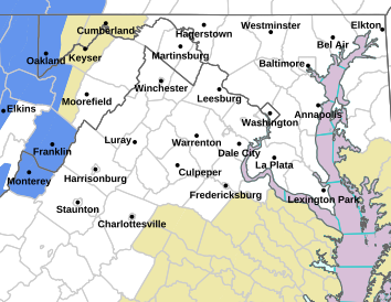
FREEZING RAIN ADVISORY ! EXPIRED ! 

0

Via NWS : A freezing rain advisory remains in until 12 noon Saturday for many areas.
FREEZING RAIN ADVISORY NOW IN EFFECT UNTIL NOON EST TODAY
URGENT – WINTER WEATHER MESSAGE
NATIONAL WEATHER SERVICE BALTIMORE MD/WASHINGTON DC
653 AM EST SAT DEC 17 2016

CHARLES-ST. MARYS-CALVERT-AUGUSTA-ROCKINGHAM-PAGE-NELSON-
ALBEMARLE-GREENE-MADISON-RAPPAHANNOCK-ORANGE-CULPEPER-STAFFORD-
SPOTSYLVANIA-KING GEORGE-SOUTHERN FAUQUIER-WESTERN HIGHLAND-
EASTERN HIGHLAND-NORTHERN VIRGINIA BLUE RIDGE-
CENTRAL VIRGINIA BLUE RIDGE-WESTERN PENDLETON-EASTERN PENDLETON-
653 AM EST SAT DEC 17 2016

…FREEZING RAIN ADVISORY NOW IN EFFECT UNTIL NOON EST TODAY…

* HAZARD TYPES…FREEZING RAIN.

* ICE ACCUMULATIONS…UP TO A TENTH-INCH.

* TIMING…PERIODS OF FREEZING RAIN WILL CONTINUE THIS MORNING. IT
WILL CHANGE TO RAIN AS TEMPERATURES WARM ABOVE FREEZING TOWARDS
NOON.

Original post
FREEZING RAIN ADVISORY REMAINS IN EFFECT FROM MIDNIGHT UNTIL TO 9 AM EST SATURDAY
URGENT – WINTER WEATHER MESSAGE
NATIONAL WEATHER SERVICE BALTIMORE MD/WASHINGTON DC
809 PM EST FRI DEC 16 2016

CHARLES-ST. MARYS-CALVERT-AUGUSTA-ROCKINGHAM-PAGE-NELSON-
ALBEMARLE-GREENE-MADISON-RAPPAHANNOCK-ORANGE-CULPEPER-STAFFORD-
SPOTSYLVANIA-KING GEORGE-SOUTHERN FAUQUIER-WESTERN HIGHLAND-
EASTERN HIGHLAND-NORTHERN VIRGINIA BLUE RIDGE-
CENTRAL VIRGINIA BLUE RIDGE-WESTERN PENDLETON-EASTERN PENDLETON-
809 PM EST FRI DEC 16 2016

…FREEZING RAIN ADVISORY REMAINS IN EFFECT FROM MIDNIGHT TONIGHT
TO 9 AM EST SATURDAY…

* HAZARD TYPES…FREEZING RAIN.

* ICE ACCUMULATIONS…LESS THAN A TENTH-INCH.

* TIMING…PERIODS OF FREEZING RAIN WILL DEVELOP AFTER
MIDNIGHT… AND BECOME STEADY TOWARD DAWN. FREEZING RAIN WILL
CHANGE TO RAIN AS TEMPERATURES WARM THROUGH MID MORNING.

* IMPACTS…HAZARDOUS TRAVEL IS EXPECTED DUE TO ICY ROADS AND
WALKWAYS.

* WINDS…SOUTH 5 TO 15 MPH.

* TEMPERATURES…MID 20S TO START… RISING TO THE LOWER 30S BY
MID MORNING.

PRECAUTIONARY/PREPAREDNESS ACTIONS…

A FREEZING RAIN ADVISORY MEANS THAT PERIODS OF FREEZING RAIN OR
FREEZING DRIZZLE WILL CAUSE TRAVEL DIFFICULTIES. BE PREPARED FOR
SLIPPERY ROADS. SLOW DOWN AND USE CAUTION WHILE DRIVING.

&&

$$
URGENT – WINTER WEATHER MESSAGE
NATIONAL WEATHER SERVICE BLACKSBURG VA
801 PM EST FRI DEC 16 2016


…LIGHT ICING TO PRODUCE SLIPPERY ROADS AND SIDEWALKS OVERNIGHT
INTO EARLY SATURDAY MORNING..
.

.WARMING TEMPERATURES ALOFT WILL OVERRUN LEFTOVER VERY COLD AIR
AT THE GROUND…PRODUCING AREAS OF FREEZING RAIN AND FREEZING
DRIZZLE OVERNIGHT INTO EARLY SATURDAY MORNING.

VAZ010>014-018>020-022>024-034-035-045>047-059-WVZ042>044-507-508-
171000-
/O.CON.KRNK.ZR.Y.0001.161217T0300Z-161217T1400Z/
BLAND-GILES-WYTHE-PULASKI-MONTGOMERY-CRAIG-ALLEGHANY VA-BATH-
ROANOKE-BOTETOURT-ROCKBRIDGE-BEDFORD-AMHERST-CAMPBELL-APPOMATTOX-
BUCKINGHAM-CHARLOTTE-MERCER-SUMMERS-MONROE-EASTERN GREENBRIER-
WESTERN GREENBRIER-
INCLUDING THE CITIES OF…BLAND…PEARISBURG…WYTHEVILLE…
RADFORD…PULASKI…BLACKSBURG…NEW CASTLE…CLIFTON FORGE…
COVINGTON…HOT SPRINGS…ROANOKE…SALEM…FINCASTLE…
LEXINGTON…BUENA VISTA…BEDFORD…AMHERST…LYNCHBURG…
APPOMATTOX…KEYSVILLE…BLUEFIELD…HINTON…HIX…UNION…
LEWISBURG…WHITE SULPHUR SPRINGS…QUINWOOD…DUO…RAINELLE
801 PM EST FRI DEC 16 2016

…FREEZING RAIN ADVISORY REMAINS IN EFFECT FROM 10 PM THIS
EVENING TO 9 AM EST SATURDAY…

* LOCATIONS…SOUTHEAST WEST VIRGINIA…AS WELL PARTS OF THE
VIRGINIA PIEDMONT INCLUDING THE NEW RIVER AND ROANOKE VALLEYS
INTO THE SOUTHERN SHENANDOAH VALLEY OF VIRGINIA.

* HAZARD TYPES…LIGHT FREEZING RAIN AND FREEZING DRIZZLE.

* ACCUMULATIONS…UP TO A FEW HUNDREDTHS OF AN INCH OF ICE
ACCUMULATION…PRODUCING A LIGHT GLAZE ON ROADS AND SIDEWALKS.

* TIMING…INTERMITTENT… LIGHT FREEZING RAIN OR FREEZING DRIZZLE
SHOULD BEGIN AFTER MIDNIGHT…THEN CONTINUING THROUGH THE
OVERNIGHT HOURS. LIGHT FREEZING RAIN OR FREEZING DRIZZLE ENDS AS
A COLD RAIN BY 9 AM AS TEMPERATURES WARM ABOVE FREEZING.

* IMPACTS…ROADWAYS AND SIDEWALKS WILL BE SLIPPERY IF LEFT
UNTREATED.

* WINDS…SOUTH 10 TO 15 MPH WITH GUSTS UP TO 25 MPH.

* TEMPERATURES…RISING IN THE 20S THROUGH THE OVERNIGHT…
REACHING THE MID 30S BY 9 AM SATURDAY.

PRECAUTIONARY/PREPAREDNESS ACTIONS…

A FREEZING RAIN ADVISORY MEANS THAT PERIODS OF FREEZING RAIN OR
FREEZING DRIZZLE WILL CAUSE TRAVEL DIFFICULTIES. BE PREPARED FOR
SLIPPERY ROADS. SLOW DOWN AND USE CAUTION WHILE DRIVING.

High Winds Cause Power Outages (Most Restored) – Along With Bitterly Cold Temperatures – 2:15PM Update

0
As of 2:15 PM Thursday the number of outages reported on the CVEC system were less than 10 down from a peak earlier in the morning of 1839.
As of 2:15 PM Thursday the number of outages reported on the CVEC system were less than 10 down from a peak earlier in the morning of 1988.

Nelson County, Virginia

Scroll down for updates

Winds gusting as high as 61 MPH in the mountains of Nelson County have caused some power outages across the area Thursday morning. A strong cold front that moved through overnight allowed bitterly cold winds to settle in before daylight. That also cause some power outages across the area.

“With high winds and falling trees, Central Virginia Electric Cooperative reported 1988 members without service earlier this morning Crews have been working at outage locations and restored service to many. One major outage was affecting 1269 members fed by a circuit out of the Martins Store substation in Nelson County. Once that cleared the outage totals fell,”

Greg Kelly the Communications & Public Relations Manager at Central Virginia Electric said around 10AM Thursday.

11:56 AM Update via Greg Kelly at CVEC:

Outage totals are down to 54 members with the remainder being addressed. There is a continued potential for high winds, which has been the cause of the outages today.

Those outages were down to just over 10 customers as of 2:15 PM Thursday.

10:24 AM Update via Greg Kelly at CVEC:

“Crews have cleared a major outage in Nelson County (Martins Store substation), dropping the outage total to 544 members.
Crews continue to work on an outage near Crozet (Midway substation) and on the circuit that feeds Long Mountain in Amherst County (Piney River substation).
High winds this morning caused trees to fall onto power lines. Crews must clear the trees, make necessary repairs and re-energize the line. Sometimes another fault location is then exposed when the line is re-energized and work begins at the new fault location downline.
If a member receive a callback or message from CVEC indicating that power should be restored and it is not, the member should report the outage by calling 800-367-2832, online at www.mycvec.com, or by using the CVEC mobile app. A crew will head to the new fault location.”

At 9:45 AM Thursday morning - December 15, 2016 the temperature from our weather station at the Nature Foundation at Wintergreen was 10° with a wind chill of -7°
At 9:45 AM Thursday morning – December 15, 2016 the temperature from our weather station at the Nature Foundation at Wintergreen was 10° with a wind chill of -7°
Even a few thousand feet below in the valley, our Trager Brothers 2.0 weather station at the Rockfish Valley Community Center was reporting a temp of 26° at 9:45 AM with a wind chill of 17°.

The winds won’t be dying down much through today, but begin tapering off some tonight into Friday.

Staunton / Augusta : VDOT Pretreating Roadways Anticipating Some Wintry Weather Late Friday Night

0
Photos courtesy of VDOT Staunton, Virginia : Crew were getting ready to hit the highways and pretreat Wednesday in anticipation of some wintry weather that's predicted for the area late Friday night into early Saturday morning.
Photos courtesy of VDOT Staunton, Virginia : Crews were getting ready to hit the highways and pretreat Wednesday in anticipation of some wintry weather that’s predicted for the area late Friday night into early Saturday morning.

Staunton
Augusta County, Virginia

As Tommy has mentioned in his forecast, the potential for some wintry weather is on the horizon during the timeframe from late Friday night into Saturday morning of this weekend. Subfreezing temps will be in place during that period until warm air begins moving into the area around noonish Saturday. Before that a mixture of freezing rain, snow and sleet is possible.

Once the temps warm up on Saturday everything is expected to change over to plain rain, but it may take several hours for that to happen, especially in the higher elevations.

Nelson : Countywide Outdoor Burn Ban Lifted

0

countywide-burn-ban-lifted

Lovingston
Nelson County, Virginia

The countywide burn ban that’s been in effect for Nelson County since November 21, 2016 was lifted this Tuesday afternoon December 13, 2016.

Bold Rock & Wintergreen Resort Present Over $3000 To Nelson County Community Fund

0
Photo Courtesy of Wintergreen Resort : Pictured l. to r.: Lindsay Dorrier III, Sue Love, Donna McCurdy, Jane Francie, Hank Thiess, Rudy Strickland, Ika Joiner and Joe Steele are all smiles as a check for $3379.41 is presented to the Nelson County Community Fund last week on December 8, 2016.

Nellysford
Nelson County, Virginia

Way to go for everyone participating in the Be Thankful 5K presented by Wintergreen Resort and Bold Rock Hard Cider on November 25, 2016 at Bold Rock Cidery. 306 people participated in the race raising $3379.41 for the Nelson County Community Fund!

Nelson : Roseland / Wintergreen : Cole’s Back!

0
©™2016 Blue Ridge Life Magazine / Nelson County Life Magazine : Photos By Digital Media Director Tommy Stafford : 10 year old Cole Chambers-Smithson draws up some yummy hot chocolate to serve from his coco stand in front of The Ski Barn at the foot of Wintergreen in Nelson County, Virginia. Saturday - December 10, 2016
©™2016 Blue Ridge Life Magazine / Nelson County Life Magazine : Photos By Digital Media Director Tommy Stafford : 10 year old Cole Chambers-Smithson draws up some yummy hot chocolate to serve from his coco stand in front of The Ski Barn at the foot of Wintergreen in Nelson County, Virginia. Saturday – December 10, 2016

Roseland / Beech Grove
Nelson County Virginia

Right at the end of last winter back in March 2016 we told you about Cole Chambers-Smithson and his hot coco stand in front of The Ski Barn in Nelson County.

Above our March 2016 story on Cole's Coco. Click on the image to read that story.
Above our March 2016 story on Cole’s Coco. Click on the image to read that story.

The cold days of winter 2016-2017 are back and so is Cole. We found his stand all setup and ready to go for this year’s ski season. A little elf told us Cole is working hard this year to make money for Christmas gifts he wants to buy!

To see more photos from Saturday’s visit, click on our Facebook album above. Better yet, drive on down and get some yummy hot chocolate or Russian Tea from Cole!

It right at the intersection of Route 664 and 151 in Nelson County on the way up to Wintergreen. Near Devils Backbone.

News Alert : Nelson : Afton Distillery Owner Announces 2017 Run For Virginia Governor

2

File. Denver Riggleman, founder and owner OF Silverback Distillery in Afton, Virginia announces he will be running for governor in 2017. He will face other republican challengers in the 2017 primary next year.
Denver Riggleman, founder and owner of Silverback Distillery in Afton, Virginia announces he will be running for governor in 2017. He first must beat other republican challengers in the primary next year.
Afton
Nelson County, Virginia

In an exclusive interview with BRL Publisher and Digital Media Director Tommy Stafford, Nelson Distillery owner and former Air Force Intelligence Officer Denver Riggleman announces his run for governor. First he must face several opponents in the 2017 Republican Primary that will be held next year.

“I’m setting up an exploratory committee now,” Riggleman says. 

Rather than writing all about it, just listen below to my interview with Denver by hitting play.

Wintergreen Fire Chief Discusses Plan In The Event Gatlinburg Happens Here : Video Interview

0


Above, Wintergreen Fire & Rescue Chief Curtis Sheets chats with BRL Digital Media Director Tommy Stafford about their plans in the event a Gatlinburg scenario played out here on the mountain. Click play above to watch.

Wintergreen Resort
Nelson County, Virginia

With the recent wildfires in Gatlinburg still in the news coupled with the outbreak we experienced here in the Blue Ridge in late November, many are asking the question what would happen at Wintergreen if a similar event occurred here.

I asked that question of Wintergreen Fire & Rescue Chief Curtis Sheets during the Gatlinburg fires and the ones burning here in the Blue Ridge. He recently took a few minutes to discuss their plan of action.

Photo By Tommy Stafford : BRL Digital Media Director : Chief Curtis Sheets of Wintergreen Fire & Rescue shows off one of the portable evacuation route signs that would be used in the even of a wildfire emergency on the mountain. Wednesday - December 7, 2016
Photo By Tommy Stafford : BRL Digital Media Director : Chief Curtis Sheets of Wintergreen Fire & Rescue shows off one of the portable evacuation route signs that would be used in the even of a wildfire emergency on the mountain. Wednesday – December 7, 2016

Below is the verbatim letter Chief Sheets sent to those living at and nearby to Wintergreen:

Dear Wintergreen owners and neighbors;

Many of you have reached out via email and social media regarding the recent fires in Gatlinburg TN and the relevance to Wintergreen. First and foremost, our thoughts and prayers are with the many families affected by the tragic fires. Our utmost respect goes out to our fellow firefighters who fought valiantly to save life and property under horrific conditions.
The similarities between Wintergreen and Gatlinburg are certainly significant. In fact, in many of the preliminary reports I have read, if one were to insert “Wintergreen VA” everywhere it reads “Gatlinburg TN” the story continues to make sense. Our topography, structure load, proximity to National Park land, and even the insurance rating of our fire department are all nearly identical.

Wintergreen long ago identified the need to communicate real-time information to owners and guests regarding urgent safety needs. Using the Wintergreen Alert system and the Wintergreen Resort switchboard we can reach thousands of people within minutes. In fact, our last “priority message” regarding a forest fire in Lovingston was confirmed by over 1,000 people in less than 10 minutes.
Since 2008 Wintergreen has participated in a fire risk reduction program referred to as “Firewise Communities USA”. Firewise Communities is a program managed by the National Fire Protection Association which is designed to recognize those communities at risk for a significant wildfire and attempt to mitigate hazards.

In 2010, Wintergreen Fire Department and the Virginia Department of Forestry collaborated on the creation of a very detailed “Pre-fire Attack Plan”. This working document identifies all partners and parameters associated with wildfire at Wintergreen.
Much like Gatlinburg, Wintergreen can be adversely affected by wildfire management strategy on National Park property. We have a wonderful working relationship with our local Park Rangers however we will likely never change the National Park Service policy regarding how aggressively fires are fought within the Park.

In full candor, much of the fire planning at Wintergreen has been built upon the industry accepted theory that East-coast fires are nothing like West-coast fires. Humidity levels of ground fuel, prevailing winds, average temperatures, etc. are all markedly different in our region and therefore it has always been said that fires here would move at a more manageable pace than those we often see on the news out West. The Gatlinburg fire certainly brings a new data-set to the table which I’m certain will affect planning as we move forward.
In the event of a large-scale fire Wintergreen Fire Department staff will make the decision regarding evacuation quickly. Once the decision has been made all available resources will be assigned to facilitating evacuation.

We do have an evacuation plan in place which involves crossing approximately 350’ of National Park property. The route begins on Laurel Springs Drive and ends on the Blue Ridge Parkway. Wintergreen has for over 20 years petitioned the National Park Service to allow us to build a gravel road which would be covered by mulch and secured with a locked gate. This is in-fact the only reasonable way out of Wintergreen if for some reason Wintergreen Drive becomes blocked. The National Park is indeed a very precious resource, and therefore the Park Service is steadfast in their commitment to environmental preservation. Wintergreen is not seeking any type of easement for our emergency exit. Rather, we simply seek an administrative approval which can be approved/rejected annually based up on our compliance with regulations. With every change of administration in Washington D.C. the process starts over, but we keep trying. Regardless, if we need to exit emergently to the Parkway, we will do so.

As your Chief of Fire & Rescue I’m tasked with making the community as safe as possible. I will commit to you the Gatlinburg fires will cause a complete evaluation of all wildfire plans. With this new data available, we must validate all existing policies and make adjustments as indicated by evidence. We will work closely with the Virginia Department of Forestry as they collaborate with their peers in Tennessee. When appropriate, we may even visit Gatlinburg to see first-hand the devastation and hope to learn from our counterparts how they feel we could be better prepared.

What I will not do, (what I have never done) is tell you not to worry about fires at Wintergreen. We shouldn’t be afraid, however we should all be vigilant. Prevention responsibilities are shared equally between all persons who spend time at Wintergreen, and all persons who live or visit the valley floors and/or Blue Ridge Parkway. The old adage says, “there’s safety in numbers.” It will take us all to keep Wintergreen safe. I have no doubt we can achieve the goal.

Christmas Eve Lessons and Carols Service At Holy Cross Episcopal Church Near Batesville

0
Photo courtesy of Holy Cross Episcopal Church

Route 635 / Greenfield Road
Between Greenfield & Batesville, Virginia

Saturday, December 24, 4pm

Holy Cross Episcopal Church
2523 Craigs Store Road
(Approximately 4 miles south of Batesville or
Approximately 5 miles east of Route 151)

Open to the whole community!

Join us for cookies and cider in the parish hall at 3:30

To seen other Christmas events and services around the area, check out our online calendar by clicking here.

Nelson : Wintergreen : A Bit Of Ice Up Top

0
Thanks to Dima Holmes of Wintergreen Real Estate Company's mountain office for this photo of the ice encasing a shrub outside their office on Devils Knob around 3500 feet. Monday - December 6, 2016
Thanks to Dima Holmes of Wintergreen Real Estate Company’s mountain office for this photo of the ice encasing a shrub outside their office on Devils Knob around 3500 feet. Monday – December 6, 2016

Wintergreen
Nelson County, Virginia

As expected a wintry mix of sleet and freezing rain has been falling most of the morning in the higher elevations along the Blue Ridge Parkway and places like Wintergreen.

With temps hovering in the upper 20s to around 30 degrees, rain has been freezing on contact with some surfaces. While roads haven't been a problem overall, shrubs, decks, and cars have picked some ice accumulation.
With temps hovering in the upper 20s to around 30 degrees, rain has been freezing on contact with some surfaces. While roads haven’t been a problem overall, shrubs, decks, and cars have picked some ice accumulation.

In the lower elevations temps have been high enough to just have a plain old cold rain. Up above people along the parkway and Skyline Drive will continue seeing a mixture of skeet and freezing rain this afternoon.

The rain ends tonight and sunny skies return Wednesday.

- Advertisement -