
Wintergreen
Nelson County, Virginia
We told you about the snow in our earlier post here and here.
Dima Holmes got more pics that we are sharing here. Just beautiful!

Very pretty Indeed!
Thanks for sharing Dima!

Wintergreen
Nelson County, Virginia
We told you about the snow in our earlier post here and here.
Dima Holmes got more pics that we are sharing here. Just beautiful!
Very pretty Indeed!
Thanks for sharing Dima!


Nellysford
Nelson County, Virginia
As we told you overnight Sunday, high winds cause numerous power outages across the area both in Nelson (where we are located) and across the Central Virginia Blue Ridge.
Our BRL WeatherNow network clocked the highest wind gust of 55 MPH at our BRL Ski Barn location on Sunday night. We’ve seen a gust of 50 MPH on Monday morning as well.
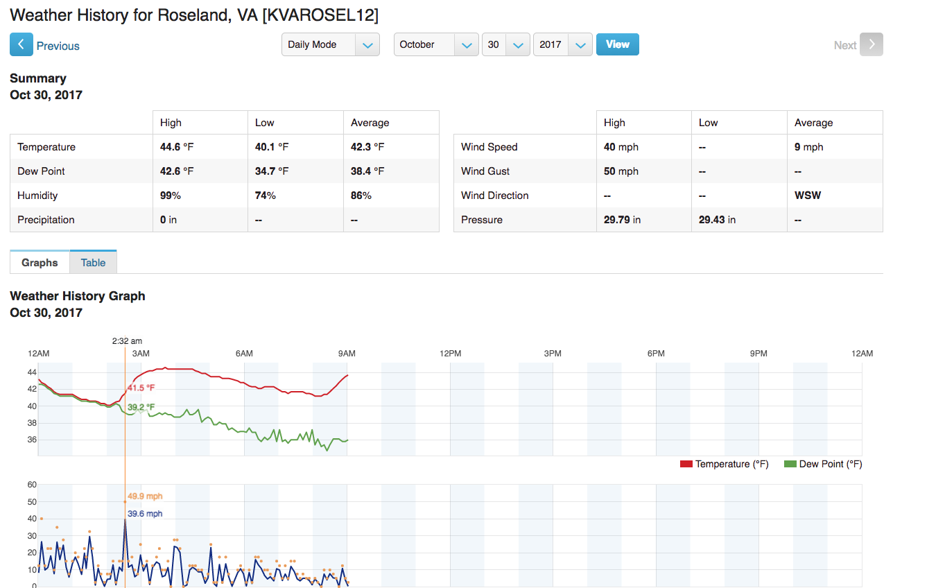


By mid morning Monday most of the power outages in Nelson had been resolved though other locations were still without power in surrounding counties.


Wintergreen
Nelson County, Virginia
Sunday night we told you about the snow starting to fall up at Wintergreen in this post.

Once daylight rolled around Monday morning you’re able to see that a respectable amount of snow fell, for late October that is!


Though it’s a cold start to the week, temps moderate as we finish off October and head into November. I talk more about that in my weather, here.


Devils Knob / Wintergreen
Nelson County, Virginia
Temps started diving late in the day Sunday along with extremely gusty winds kicking in. Just the right ingredients for some light snow to begin falling at Wintergreen in the higher elevations.
“Raised wood decks and walkways are very slick. And they’re a lot of them up here!” That’s what John told us just before 9PM Sunday night.

Additionally around 9:25 PM Sunday night numerous reports of trees and limbs down in Stoney Creek in Nellysford have been reported.

Not to worry, warmer days are ahead but it’s a sure sign of changing weather in the not too distant future!


Afton
Nelson County, Virginia
Ten years ago in October 2017 Blue Mountain Brewery in Afton celebrated 10 years in business. They were the first craft brewery established in Nelson County.
Above our October 2017 store in the printed edition of Blue Ridge Life Magazine where writer/photographer Marcie Gates remembers and helps celebrate 10 years of Blue Mountain Brewery. Click to above on the full screen icon to read.
For a fun look back at some of the memories, check out out our Facebook photo albums down below.


Congrats BMB and here’s to 10 more!

WIND ADVISORY
URGENT – WEATHER MESSAGE
National Weather Service Baltimore MD/Washington DC
349 AM EDT Mon Oct 30 2017
VAZ025-026-029-503-504-507-508-WVZ505-506-301400-
/O.CON.KLWX.WI.Y.0015.000000T0000Z-171030T1400Z/
Augusta-Rockingham-Page-Western Highland-Eastern Highland-
Northern Virginia Blue Ridge-Central Virginia Blue Ridge-
Western Pendleton-Eastern Pendleton-
Including the cities of Staunton, Waynesboro, Stuarts Draft,
Harrisonburg, Luray, Shenandoah, Stanley, Hightown, Monterey,
Big Meadows, Wintergreen, Riverton, Brandywine, Franklin,
Oak Flat, Ruddle, and Sugar Grove
349 AM EDT Mon Oct 30 2017
…WIND ADVISORY REMAINS IN EFFECT UNTIL 10 AM EDT THIS MORNING…
* TIMING…Through mid-morning. The strongest winds will be
through 6 AM.
* WINDS…West to northwest 20 to 35 mph with around 50 mph for
elevations above 2000 feet.
* IMPACTS…Strong winds may blow down limbs, trees, and power
lines. Scattered power outages are expected.
PRECAUTIONARY/PREPAREDNESS ACTIONS…
A Wind Advisory means that winds around 50 mph are expected.
Winds this strong can make driving difficult, especially for high
profile vehicles.
URGENT – WEATHER MESSAGE
National Weather Service Blacksburg VA
442 AM EDT Mon Oct 30 2017
…Strong gusty winds through this morning…
.Low pressure over upstate New York will move away from the Mid
Atlantic Region today. Strong winds this morning will diminish
this afternoon as the low pressure system moves away from the
area.
NCZ001>003-018-019-VAZ009>020-022>024-032>035-301500-
/O.CON.KRNK.WI.Y.0017.000000T0000Z-171030T1500Z/
Ashe-Alleghany NC-Surry-Watauga-Wilkes-Smyth-Bland-Giles-Wythe-
Pulaski-Montgomery-Grayson-Carroll-Floyd-Craig-Alleghany VA-Bath-
Roanoke-Botetourt-Rockbridge-Patrick-Franklin-Bedford-Amherst-
Including the cities of West Jefferson, Sparta, Dobson, Boone,
Wilkesboro, Marion, Bland, Pearisburg, Wytheville, Radford,
Pulaski, Blacksburg, Independence, Whitetop, Troutdale, Volney,
Galax, Floyd, New Castle, Clifton Forge, Covington, Hot Springs,
Roanoke, Salem, Fincastle, Lexington, Buena Vista, Stuart,
Rocky Mount, Bedford, and Amherst
442 AM EDT Mon Oct 30 2017
…WIND ADVISORY REMAINS IN EFFECT UNTIL 11 AM EDT THIS MORNING…
* Locations…High Country and Highlands of North Carolina and
Virginia, to the foothills of the Blue Ridge.
* Hazards…Strong winds.
* Winds…Northwest 15 to 25 mph, with gusts up to 50 mph.
* Timing…through Monday morning.
* Impacts…Downed tree limbs and branches. Possible power
outages.
PRECAUTIONARY/PREPAREDNESS ACTIONS…
A Wind Advisory is issued when sustained winds are forecast to be
31 to 39 MPH or gusts will range between 46 and 57 MPH. Winds of
these magnitudes may cause minor property damage without extra
precautions. Motorists in high profile vehicles should use extra
caution until the winds subside.
 (Video)")

Covesville
Albemarle County, Virginia
A bus from Fresta Valley School carrying their soccer team burst into flames late Saturday afternoon in Covesville along Route 29. The private school is located in Fauquier County, Virginia.

Above the video embedded into our site.
According to our media partners over at CBS19 News (in this post) no injuries occurred from the fire and everyone got off the bus safely.

Woods Mill
Nelson County, Virginia
Traffic was delayed Thursday afternoon when a crash occurred at the intersection of River Road & US 29. Crews were working to clear the scene around 5PM and long delays are not expected.
No information on injuries (if any) at this time.
Northbound traffic going past the accident was not affected.
")

FROST ADVISORY
URGENT – WEATHER MESSAGE
National Weather Service Baltimore MD/Washington DC
1037 AM EDT Thu Oct 26 2017
District of Columbia-Frederick MD-Carroll-Northern Baltimore-
Southern Baltimore-Prince Georges-Anne Arundel-Charles-St. Marys-
Calvert-Northwest Montgomery-Central and Southeast Montgomery-
Northwest Howard-Central and Southeast Howard-Northwest Harford-
Southeast Harford-Nelson-Albemarle-Greene-Orange-
Prince William/Manassas/Manassas Park-Fairfax-
Arlington/Falls Church/Alexandria-Stafford-Spotsylvania-
King George-Northern Fauquier-Southern Fauquier-Western Loudoun-
Eastern Loudoun-
Including the cities of Washington, Frederick, Ballenger Creek,
Eldersburg, Westminster, Reisterstown, Cockeysville, Baltimore,
Bowie, Suitland-Silver Hill, Clinton, College Park, Greenbelt,
Laurel, Camp Springs, Glen Burnie, Annapolis, Severn, South Gate,
Severna Park, Arnold, Odenton, St. Charles, Waldorf,
Lexington Park, California, Chesapeake Beach, Huntingtown,
Dunkirk, North Beach, Lusby, Prince Frederick, Germantown,
Damascus, Bethesda, Rockville, Gaithersburg, Silver Spring,
Lisbon, Columbia, Ellicott City, Jarrettsville, Aberdeen,
Lovingston, Charlottesville, Stanardsville, Orange, Gordonsville,
Dale City, Manassas, Woodbridge, Lake Ridge, Montclair, Reston,
Herndon, Annandale, Centreville, Chantilly, McLean, Franconia,
Arlington, Alexandria, Falmouth, Fredericksburg, Dahlgren,
Warrenton, Turnbull, Purcellville, Leesburg, Ashburn,
and Sterling
1037 AM EDT Thu Oct 26 2017
…FROST ADVISORY REMAINS IN EFFECT FROM MIDNIGHT TONIGHT TO 9 AM
EDT FRIDAY…
* TEMPERATURES…Falling into the mid 30s by dawn, mainly away
from the urban centers and large bodies of water.
* IMPACTS…Sensitive outdoor plants may be damaged or killed by
frost if left uncovered.
PRECAUTIONARY/PREPAREDNESS ACTIONS…
A Frost Advisory means that widespread frost is expected.
Sensitive outdoor plants may be killed if left uncovered.
URGENT – WEATHER MESSAGE
National Weather Service Blacksburg VA
301 PM EDT Thu Oct 26 2017
…Frost developing late tonight…
.High pressure will bring clear skies and light winds to the
Appalachians and central mid atlantic region tonight. This will
allow temperatures to fall rapidly overnight and frost is
expected to develop across portions of Virginia east of the Blue
Ridge, as well as across the foothills and piedmont of North
Carolina.
Roanoke-Botetourt-Rockbridge-Franklin-Bedford-Amherst-Campbell-
Appomattox-Buckingham-
Including the cities of Roanoke, Salem, Fincastle, Lexington,
Buena Vista, Rocky Mount, Bedford, Amherst, Lynchburg,
and Appomattox
301 PM EDT Thu Oct 26 2017
…FROST ADVISORY NOW IN EFFECT FROM 3 AM TO 9 AM EDT FRIDAY…
* Locations…Areas of Virginia east of the Blue Ridge
* Hazards…Frost.
* Temperatures…Lows in the lower to mid 30s.
* Timing…3AM to 9AM Friday.
* Impacts…Unprotected sensitive vegetation may be damaged or
killed.
PRECAUTIONARY/PREPAREDNESS ACTIONS…
A Frost Advisory means that frost is expected. Sensitive outdoor
plants may be killed if left uncovered.


Central Virginia Blue Ridge
By Tommy Stafford
Don’t throw in the towel just yet on the fall colors! Some pretty brilliant colors are starting to emerge in the higher elevations of locations across the Central Virginia Blue Ridge. A very dry late summer has hurt some of the brilliance, but there’s still plenty of leaves on the trees and lots of color starting to appear.

With frost likely over the next couple of nights, that should enhance the chances for even more color in the coming days.
Enjoy!
