Map courtesy of Friends Of Wintergreen : This map shows the path of the ACP in relation to The Fenton Inn near the entrance of Wintergreen Resort.
Nelson County, Virginia
Update: Wednesday evening May 16, 2018 via Friends of Wintergreen:
“
Original post – May 15, 2018 8:33 PM EDT:
Significant news moving this Tuesday evening regarding the Atlantic Coast Pipeline. According to a post from Friends of Wintergreen and a story from the Richmond Times Dispatch, a federal court has halted construction of the ACP.
Thanks to our media partners at CBS19 News in Charlottesville for this info.
“We are of course pleased with this decision from the 4th Circuit regarding the US Fish and Wildlife review of the ACP. Residents and groups fighting on behalf of impacted communities have long held that thousands of pages of documents do not necessarily end in a thorough review. Errors and omissions have been rife among agencies in charge, and political pressures have been glaringly obvious. We will wait for details of the court’s full opinion, but are most grateful for the Southern Environmental Law Center’s steadfast dedication to the communities all along the route of the Atlantic Coast Pipeline. It is indeed a pleasure to hear a court confirm the deficiencies in at least part of the review of this project. Given the opportunity for all of the many challenges to be heard by the courts before this pipe is laid, we are confident that this project will not be built.
Today Sheriff Hill released preliminary findings ruled by the medical examiner in Richmond. Below is Sheriff Hill’s statement verbatim:
“5/15/2018
The deaths of Deborah Lee Bruce (60 years of age) and Michelle Bruce (38 years of age) have been preliminarily ruled “Accidental Overdose” by the Medical Examiner’s Office of Richmond. The Nelson County Sheriff’s Office will continue to actively stem the sale and use of illegal narcotics in our community. We ask the community for continued support by always reporting suspicious or illegal activities.”
Photo By John Hellerman : Above lightning streaks across the sky (lower left) as severe storms move east of Afton, Virginia on Monday afternoon – May 15, 2018.
Central Virginia Blue Ridge
As Tommy discussed in his Monday weather outlook severe storms moved across the region Monday afternoon. Some of the storms were powerful enough to bring down trees and cut power to many thousands of customers.
Above, John Hellerman of Afton, Virginia captured this video of hail falling Monday afternoon. Some of the hail was ping pong size.
Above Danny Watson of Wintergreen Hardware holds some of the hail that fell in Afton, Virginia on Monday afternoon – May 14, 2018.Photo By Rebecca Martin : In nearby Lovingston strong winds blew down trees and limbs near the fire department and Meadowview Apartments. May 14, 2018Photo By Kim Sillas : Hail covers the ground near the post office in Roseland, Virginia of Nelson County on Monday afternoon – May 14, 2018
While more storms are expected on Tuesday, the brunt of severe weather looks to be to our north. Regardless a soggy week is ahead with plenty of chances for rain right into the weekend.
SILVER SPRING, SPOTSYLVANIA COURTHOUSE, ST. CHARLES,
STANARDSVILLE, SUITLAND-SILVER HILL, TOWSON, WALDORF, WARRENTON,
WASHINGTON, WASHINGTON, AND WOODBRIDGE.
(Scroll for county outline areas)
SEVERE THUNDERSTORM WATCH OUTLINE UPDATE FOR WS 88
URGENT – IMMEDIATE BROADCAST REQUESTED
Severe Thunderstorm Watch Number 88
NWS Storm Prediction Center Norman OK
1230 PM EDT Mon May 14 2018
The NWS Storm Prediction Center has issued a
* Severe Thunderstorm Watch for portions of
District Of Columbia
Western and central Maryland
Southeast Ohio
Southern Pennsylvania
Northern Virginia
Northern and central West Virginia
Coastal Waters
* Effective this Monday afternoon and evening from 1230 PM until
900 PM EDT.
* Primary threats include…
Widespread damaging winds and isolated significant gusts to 75
mph likely
Isolated large hail events to 1.5 inches in diameter possible
A tornado or two possible
SUMMARY…Strong to severe storms will quickly evolve into a squall
line that should progress east then southeast across the central
Appalachians towards Chesapeake Bay. Damaging winds will be the
primary hazard with a brief tornado or two possible.
The severe thunderstorm watch area is approximately along and 85
statute miles either side of a line from 40 miles northwest of
Parkersburg WV to 20 miles south southeast of Baltimore MD. For a
complete depiction of the watch see the associated watch outline
update (WOUS64 KWNS WOU8).
PRECAUTIONARY/PREPAREDNESS ACTIONS…
REMEMBER…A Severe Thunderstorm Watch means conditions are
favorable for severe thunderstorms in and close to the watch area.
Persons in these areas should be on the lookout for threatening
weather conditions and listen for later statements and possible
warnings. Severe thunderstorms can and occasionally do produce
tornadoes.
&&
AVIATION…A few severe thunderstorms with hail surface and aloft to
1.5 inches. Extreme turbulence and surface wind gusts to 65 knots. A
few cumulonimbi with maximum tops to 500. Mean storm motion vector
29040.
NWS STORM PREDICTION CENTER NORMAN OK
1230 PM EDT MON MAY 14 2018
SEVERE THUNDERSTORM WATCH 88 IS IN EFFECT UNTIL 900 PM EDT
FOR THE FOLLOWING LOCATIONS
ALBEMARLE ARLINGTON AUGUSTA
CLARKE CULPEPER FAIRFAX
FAUQUIER FREDERICK GREENE
HIGHLAND KING GEORGE LOUDOUN
MADISON NELSON ORANGE
PAGE PRINCE WILLIAM RAPPAHANNOCK
ROCKINGHAM SHENANDOAH SPOTSYLVANIA
STAFFORD WARREN
VIRGINIA INDEPENDENT CITIES INCLUDED ARE
ALEXANDRIA CHARLOTTESVILLE FAIRFAX
FALLS CHURCH FREDERICKSBURG HARRISONBURG
MANASSAS MANASSAS PARK STAUNTON
WAYNESBORO WINCHESTER
Image courtesy of USFS : As of Friday evening May 11, 2018 approximately 1,716 acres, including approximately 432 acres within the St. Mary’s Wilderness. This slight growth in size occurred within St. Mary’s Wilderness near Big Spy Mt. and is due to the warm temperatures and drier conditions.
Location
The Tye River Fire is located on the George Washington and Jefferson National Forests, approximately 3 miles east of Vesuvius.
Counties
Augusta and Rockbridge Counties, VA
Estimated Acreage
Approximately 1,716 acres, including approximately 432 acres within the St. Mary’s Wilderness. This slight growth in size occurred within St. Mary’s Wilderness near Big Spy Mt. and is due to the warm temperatures and drier conditions.
Containment
The fire is currently 60% contained. No structures are threatened at this time.
Cause and Date Started
The cause was a vehicle fire on VA Hwy 56, that quickly spread northeast onto National Forest lands and nearby private lands. The fire was first reported at approximately 5:45 PM on Thursday May 3, 2018.
Resources on the Fire
Approximately 59 firefighters and support staff, including 2 hand crews, 3 wildland engines, 3 dozers, and 2 helicopter are currently assigned to this incident. These resources are from throughout Virginia and several other states.
Cooperators
The fire is being managed by the U.S. Forest Service as a Type 4 incident by Incident Commander Jason Hattersley.
Cooperators include Blue Ridge Parkway-National Park Service, Virginia Department of Forestry, Augusta County Fire and Rescue, Rockbridge County Fire and Rescue, several local volunteer fire departments, and the Virginia Department of Transportation.
Restrictions and Closures
Travelers on VA Hwy 56 between Vesuvius and the Blue Ridge Parkway are advised to use caution traveling this steep narrow road and be aware of firefighters, fire equipment and other road improvement equipment.
Restrictions and Closures
All trails within Saint Mary’s Wilderness are now open EXCEPT Mine Bank Mountain Trail (FT #503) which remains CLOSED.
The public, including hikers, are not allowed off designated trails in the portion of St. Mary’s Wilderness that is south of St. Mary’s Trail (FT #500) and west of Mine Bank Creek Trail(FT #500C).
Use caution and obey all trail and area closures for your safety.
Firefighting
Emphasis
Firefighters are continuing to patrol and mop-up along the firelines. Fireline rehabilitation efforts are still underway.
Small portions of the fire will remain unstaffed within Saint Mary’s Wilderness due to inaccessibility and rugged terrain.
This area is still being routinely monitored by ground and air resources. There will be a coordinated response if fire activity increases.
Other Fire
Information
The top priority for fire managers is public and firefighter safety.
Please be extra careful traveling in the area this weekend with heightened recreational visitors and firefighters sharing the roadways.
Blue Ridge Parkway travelers, area residents and visitors can expect to see and smell smoke.
Fire rehabilitation efforts and monitoring current perimeter will continue over the next several days. Helicopter bucket drops are also being utilized when needed to keep fire activity at a low to moderate level.
Fire behavior may increase moderately due to forecasted higher temperatures and dry conditions.
Fire managers and firefighters appreciate the support shown by residents and the local communities.
The next fire update will be available as changes in fire activity occur.
Above a screen grab of the approaching thunderstorms Thursday afternoon as seen from our BRL-SkiBarn Webcam on May 10, 2018. The time lapse video is below.
Roseland
Nelson County, Virginia
As I talked about on Thursday, the potential for severe weather was decent that afternoon. Sure enough it starting hitting about mid afternoon with numerous severe thunderstorm warnings being issued. (If you have our BRL Smartphone app you can get those alerts right to your Iphone or Droid.) In some areas like Albemarle and Northern Nelson trees were blown down and some power lines in Charlottesville as well.
Above check out a cool time lapse video of when the storms crossed the Blue Ride Parkway as seen from our BRL-SkiBarn webcam looking west towards Devils Backbone Brewing at the intersection of Route 664 & 151 in Nelson County at the foot of Wintergreen.
URGENT – IMMEDIATE BROADCAST REQUESTED
Severe Thunderstorm Watch Number 78
NWS Storm Prediction Center Norman OK
110 PM EDT Thu May 10 2018
The NWS Storm Prediction Center has issued a
* Severe Thunderstorm Watch for portions of
District Of Columbia
Northern Maryland
North-central North Carolina
Much of Virginia
The Eastern Panhandle of West Virginia
Coastal Waters
* Effective this Thursday afternoon and evening from 110 PM until
700 PM EDT.
* Primary threats include…
Scattered damaging wind gusts to 70 mph likely
Isolated very large hail events to 2 inches in diameter possible
SUMMARY…Thunderstorms are forming over eastern West Virginia and
western Virginia. These storms will spread eastward this afternoon
across the watch area, posing a risk of locally damaging wind gusts
and perhaps hail.
The severe thunderstorm watch area is approximately along and 65
statute miles east and west of a line from 35 miles north of
Baltimore MD to 30 miles west southwest of South Hill VA. For a
complete depiction of the watch see the associated watch outline
update (WOUS64 KWNS WOU8).
PRECAUTIONARY/PREPAREDNESS ACTIONS…
REMEMBER…A Severe Thunderstorm Watch means conditions are
favorable for severe thunderstorms in and close to the watch area.
Persons in these areas should be on the lookout for threatening
weather conditions and listen for later statements and possible
warnings. Severe thunderstorms can and occasionally do produce
tornadoes.
BULLETIN – IMMEDIATE BROADCAST REQUESTED
SEVERE THUNDERSTORM WATCH OUTLINE UPDATE FOR WS 78
NWS STORM PREDICTION CENTER NORMAN OK
110 PM EDT THU MAY 10 2018
SEVERE THUNDERSTORM WATCH 78 IS IN EFFECT UNTIL 700 PM EDT
FOR THE FOLLOWING LOCATIONS
ALBEMARLE AMELIA AMHERST
APPOMATTOX ARLINGTON AUGUSTA
BEDFORD BRUNSWICK BUCKINGHAM
CAMPBELL CAROLINE CHARLES CITY
CHARLOTTE CHESTERFIELD CLARKE
CULPEPER CUMBERLAND DINWIDDIE
ESSEX FAIRFAX FAUQUIER
FLUVANNA FRANKLIN FREDERICK
GLOUCESTER GOOCHLAND GREENE
GREENSVILLE HALIFAX HANOVER
HENRICO HENRY JAMES CITY
KING AND QUEEN KING GEORGE KING WILLIAM
LANCASTER LOUDOUN LOUISA
LUNENBURG MADISON MECKLENBURG
MIDDLESEX NELSON NEW KENT
NORTHUMBERLAND NOTTOWAY ORANGE
PAGE PITTSYLVANIA POWHATAN
PRINCE EDWARD PRINCE GEORGE PRINCE WILLIAM
RAPPAHANNOCK RICHMOND ROCKBRIDGE
ROCKINGHAM SHENANDOAH SPOTSYLVANIA
STAFFORD SURRY SUSSEX
WARREN WESTMORELAND
VIRGINIA INDEPENDENT CITIES INCLUDED ARE
ALEXANDRIA BUENA VISTA CHARLOTTESVILLE
COLONIAL HEIGHTS DANVILLE EMPORIA
FAIRFAX FALLS CHURCH FREDERICKSBURG
HARRISONBURG HOPEWELL LEXINGTON
LYNCHBURG MANASSAS MANASSAS PARK
MARTINSVILLE PETERSBURG RICHMOND
STAUNTON WAYNESBORO WILLIAMSBURG
WINCHESTER
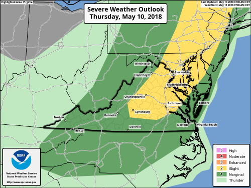
The Storm Prediction Center has placed most of our area in the slight risk area for severe weather on Thursday afternoon – May 10, 2018.
Central Virginia Blue Ridge
As the days get warmer the likelihood of stronger storms becomes more likely. The Storm Prediction Center shows the risk for some storms this afternoon across portions of the Blue Ridge in the slight category. While this is at the bottom of the risk scale, the potential is there for a few storms to become strong to severe.
I talk more about that and some hot weather to come in my Thursday audio weather update below!
You know spring and warmer weather have arrived once you see the tent going up for the Nelson Farmers Market Coop in Nellysford. The 2018 season officially kicked off on Saturday – May 5, 2018.
To see more of Paul’s photos from the opening day of the market, click on our Facebook album / post above.
The NFM runs from May through October each year and is held each Saturday from 8AM until 12 noon.
For over a month in all kinds of weather Theresa “Red” Terry perched in a tree on her property to stop workers with the Mountain Valley Pipeline from cutting trees to start construction of the highly controversial pipeline. Though not related a similar project, the Atlantic Coast Pipeline is also meeting opposition. After more than 30 days in the tree Red finally came down last week after WaPo Red Comes Down
Above in this video, Red and her daughter talk to Yvette Stafford about her wish for what might happen with the MVP.
Red may have come down from the tree, but she’s not being quiet about her ordeal and what she’s been facing. Monday night she spoke to dozens of people that gathered at Union Hill Church in Buckingham County about what’s happened so far.