
Central Virginia Blue Ridge Area
By Tommy Stafford
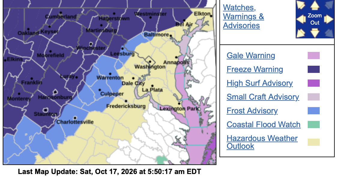
If the winds clam down enough tonight we could see the first widespread frost and light freeze to many areas of the Blue Ridge. We’ll see gusty winds all day Saturday with temps only in the 50s. By Saturday night if those winds settle down (there’s some question if that happens) then we have a good setup for frost and freezes. The freeze warning mentioned below is along and west of the Blue Ridge Parkway & Skyline Drive. Think, Wintergreen, Montebello, and Big Meadows to name a few. On the eastern side of the parkway there’s a frost advisory overnight. Think, Afton, Ivy, Greenwood to name a few there.
Down below the specifics from the NWS.
Have a great Saturday and rest of your weekend!
Tommy
FREEZE WARNING IN EFFECT FROM 1 AM TO 8 AM EDT SUNDAY
URGENT – WEATHER MESSAGE
National Weather Service Baltimore MD/Washington DC
1236 AM EDT Sat Oct 17 2026
Washington-Frederick-Carroll-Northern Baltimore-Extreme Western
Allegany-Central and Eastern Allegany-Northwest Harford-Western
Garrett-Eastern Garrett-Augusta-Rockingham-Shenandoah-Frederick-
Page-Warren-Clarke-Western Highland-Eastern Highland-Western
Loudoun-Northern Virginia Blue Ridge-Central Virginia Blue Ridge-
Hampshire-Morgan-Berkeley-Jefferson-Hardy-Western Grant-Eastern
Grant-Western Mineral-Eastern Mineral-Western Pendleton-Eastern
Pendleton-
Including the cities of McNeill, Ridgeville, Frostburg, Shenandoah
Junction, Franklin, Mill Gap, Three Churches, Kitzmiller, Magnolia,
Bayard, Rawlings, Montebello, Seymourville, Hightown, Rileyville,
Chester Gap, Compton, Hancock, Sugar Grove, Mustoe, Masonville,
Glyndon, Keyser, Paw Paw, Clary, Oak Flat, Churchville, Shady Grove,
Woodstock, Reisterstown, Owings Mills, Glen Echo, Bloomery,
Russelldale, Cedar Grove, Front Royal, Stuarts Draft, Ruddle,
Cumberland, Sulphur City, Headsville, Mount Clifton, Arco, Riverton,
Cabins, Grantsville, Christian, Antioch, Landes, Piedmont, Hamburg,
Gamber, Randallstown, Kimball, Bel Air, New Hampden, Reynolds,
Martinsburg, Howellsville, Berkeley Spgs, Halfway, Fairview, New
Creek, Linville, Purgitsville, Hagerstown, McDowell, Ranson, La Vale,
Romney, Sirons Mill, Springfield, Long Green, Timonium, Fallston,
Spottswood, Points, Bentonville, Lucketts, Park Mills, Westminster,
Brady, Fisher, Monterey, Petersburg, Cockeysville, Moorefield, Mount
Jackson, Bakerton, Eldersburg, Welton, Brake, Kline Gap, Strasburg,
Frenchburg, Hickory, Possum Trot, McCoole, Winchester, Smith
Crossroads, Bynum, Berryville, Oakland, Albin, Staunton, Ballenger
Creek, Hawkinstown, Cedarville, Buckton, Ingham, Beechwood,
Gainesboro, Millville, Luray, Wapocomo, Harrisonburg, Bean
Settlement, Wilsonia, Frederick, Stringtown, Charles Town, Middleway,
Buckeystown, Waynesboro, Fort Ashby, Clover Creek, Brandywine,
Alonzaville, Skyland, Ellerslie, Westernport, Mountain Lake Park, and
Liberty
1236 AM EDT Sat Oct 17 2026
…FREEZE WARNING IN EFFECT FROM 1 AM TO 8 AM EDT SUNDAY…
* WHAT…Sub-freezing temperatures in the upper 20s and low 30s are
possible.
* WHERE…Portions of north central and western Maryland, central,
northwest, and western Virginia, and the eastern panhandle of West
Virginia.
* WHEN…From 1 AM to 8 AM EDT Sunday.
* IMPACTS…Frost and freeze conditions could kill crops, other
sensitive vegetation and possibly damage unprotected outdoor
plumbing.
PRECAUTIONARY/PREPAREDNESS ACTIONS…
Take steps now to protect tender plants from the cold.
FROST ADVISORY IN EFFECT FROM 1 AM TO 8 AM EDT SUNDAY
URGENT – WEATHER MESSAGE
National Weather Service Baltimore MD/Washington DC
1236 AM EDT Sat Oct 17 2026
Northwest Montgomery-Northwest Howard-Nelson-Albemarle-Greene-
Madison-Rappahannock-Orange-Culpeper-Northern Fauquier-Southern
Fauquier-Eastern Loudoun-Northwest Prince William-
Including the cities of Glenwood, Catalpa, Lisbon, Castleton, Flint
Hill, Bethel, Haymarket, Woolsey, Boyds, Dayton, Gleedsville,
Leesburg, Stevensburg, Burr Hill, Greenfield, Lahore, Sterling Park,
Nasons, Charlottesville, Fordsville, Twymans Mill, Five Forks,
Culpeper, Madison Mills, Glenelg, Dulles International Airport,
Countryside, Cardova, Unionville, Rock Mills, Watersville,
Washington, Oak Grove, Madison Run, Poplar Springs, Warrenton, Reva,
Germantown, Winston, Rapidan, Turnbull, Hackleys Crossroads, West
Friendship, Overton, Shady Grove, Orange, Airlie, and Everona
1236 AM EDT Sat Oct 17 2026
…FROST ADVISORY IN EFFECT FROM 1 AM TO 8 AM EDT SUNDAY…
* WHAT…Temperatures as low as 34 will result in frost formation.
* WHERE…Portions of central Maryland and central, northern, and
northwest Virginia.
* WHEN…From 1 AM to 8 AM EDT Sunday.
* IMPACTS…Frost could harm sensitive outdoor vegetation. Sensitive
outdoor plants may be killed if left uncovered.
PRECAUTIONARY/PREPAREDNESS ACTIONS…
Take steps now to protect tender plants from the cold.
FROST ADVISORY REMAINS IN EFFECT FROM 1 AM TO 9 AM EDT SUNDAY
URGENT – WEATHER MESSAGE
National Weather Service Blacksburg VA
541 AM EDT Sat Oct 17 2026
Surry-Wilkes-Roanoke-Botetourt-Rockbridge-Patrick-Franklin-Bedford-
Amherst-
Including the cities of Buena Vista, Wilkesboro, Salem, Lexington,
Fincastle, Roanoke, Bedford, Amherst, Stuart, Dobson, and Rocky Mount
541 AM EDT Sat Oct 17 2026
…FROST ADVISORY REMAINS IN EFFECT FROM 1 AM TO 9 AM EDT SUNDAY…
* WHAT…Temperatures as low as 34 will result in frost formation.
* WHERE…In North Carolina, Surry and Wilkes Counties. In Virginia,
Amherst, Bedford, Patrick, Botetourt, Franklin, Roanoke, and
Rockbridge Counties.
* WHEN…From 1 AM to 9 AM EDT Sunday.
* IMPACTS…Frost could harm sensitive outdoor vegetation. Sensitive
outdoor plants may be killed if left uncovered.
PRECAUTIONARY/PREPAREDNESS ACTIONS…
Take steps now to protect tender plants from the cold.

