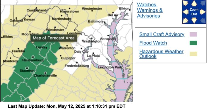
Flood Watch
National Weather Service Baltimore MD/Washington DC
110 PM EDT Mon May 12 2025
Augusta-Rockingham-Shenandoah-Page-Warren-Nelson-Albemarle-Greene-
Madison-Rappahannock-Northern Virginia Blue Ridge-Central
Virginia Blue Ridge-
110 PM EDT Mon May 12 2025
…FLOOD WATCH NOW IN EFFECT FROM 8 PM EDT THIS EVENING THROUGH LATE
TUESDAY NIGHT…
* WHAT…Flooding caused by excessive rainfall continues to be
possible.
* WHERE…Portions of central, northwest, and western Virginia,
including the following areas, in central Virginia, Albemarle,
Central Virginia Blue Ridge, Greene and Nelson. In northwest
Virginia, Madison, Northern Virginia Blue Ridge, Page,
Rappahannock, Shenandoah and Warren. In western Virginia, Augusta
and Rockingham.
* WHEN…From 8 PM EDT this evening through late Tuesday night.
* IMPACTS…Excessive runoff may result in flooding of creeks,
streams, and other low-lying and flood-prone locations. Low-water
crossings may be flooded.
* ADDITIONAL DETAILS…
– While showers will spread into the area today, a prolonged
period of moderate to heavy rain with embedded thunderstorms
is expected tonight into Tuesday night. Rainfall amounts of 2
to 4 inches are likely, with locally higher amounts possible
along the eastern slopes of the Blue Ridge Mountains. This
rainfall may lead to scattered instances of flooding.
– Please visit www.weather.gov/safety/flood for flood safety
and preparedness information
PRECAUTIONARY/PREPAREDNESS ACTIONS…
You should monitor later forecasts and be alert for possible Flood
Warnings. Those living in areas prone to flooding should be prepared
to take action should flooding develop.
Flood Watch
National Weather Service Blacksburg VA
102 PM EDT Mon May 12 2025
Stokes-Rockingham-Caswell-Floyd-Roanoke-Botetourt-Rockbridge-
Patrick-Franklin-Bedford-Amherst-Henry-Pittsylvania-Campbell-
Including the cities of Yanceyville, Salem, Lexington, Floyd,
Amherst, Stuart, Lynchburg, Danville, Roanoke, Fincastle, Rocky
Mount, Danbury, Martinsville, Eden, Bedford, and Buena Vista
102 PM EDT Mon May 12 2025
…FLOOD WATCH NOW IN EFFECT THROUGH LATE TUESDAY NIGHT…
* WHAT…Flooding caused by excessive rainfall continues to be
possible.
* WHERE…Portions of north central North Carolina, including the
following counties, Caswell, Rockingham and Stokes and Virginia,
including the following counties, Amherst, Bedford, Botetourt,
Campbell, Floyd, Franklin, Henry, Patrick, Pittsylvania, Roanoke
and Rockbridge.
* WHEN…Through late Tuesday night.
* IMPACTS…Excessive runoff may result in flooding of rivers,
creeks, streams, and other low-lying and flood-prone locations.
Creeks and streams may rise out of their banks. Flooding may occur
in poor drainage and urban areas.
* ADDITIONAL DETAILS…
– Expect multiple rounds of moderate to heavy rain through
tonight and scattered showers and thunderstorms on Tuesday
and Tuesday night. Total rainfall amounts of 2 to 4 inches
are expected, with locally higher amounts of 4 to 6 inches
along the Blue Ridge into the eastern foothills.
– http://www.weather.gov/safety/flood
PRECAUTIONARY/PREPAREDNESS ACTIONS…
You should monitor later forecasts and be alert for possible Flood
Warnings. Those living in areas prone to flooding should be prepared
to take action should flooding develop.


