
Central Virginia Blue Ridge
by Tommy Stafford
As I’ve been discussing in previous posts this week, here and here, a major winter storm is heading for the Blue Ridge area this weekend. As of late Friday morning NWS Baltimore has now upgraded to a Winter Storm Warning for all of the area from Saturday until Monday evening. That complete warning information can be found here at this link.
Cold Weather Advisories are also in effect for much of the area as well.
In addition to concerns about the snow, sleet and freezing rain, CVEC is now urging members to prepare for the worst and possible long power outages should the worst case scenario of the storm happens.
“Dear Member,
We are closely monitoring the winter storm expected to impact our service territory and we encourage everyone to take steps now to prepare for hazardous conditions and extended, multi-day power outages.
Heavy snow, ice, and frigid temperatures can place significant stress on power lines and equipment. These same conditions, combined with icy roads, fallen trees, and limited accessibility, may also slow restoration efforts. While our crews will be ready to respond as quickly as conditions allow, restoration will be dependent upon which areas our crews can access safely.
How you can prepare now:
- If you or a loved one relies on medical equipment, please ensure you have a backup power plan in place.
- Assemble a well-stocked outage kit, including flashlights, batteries, blankets, food, water, medications, and phone chargers.
- Plan for safe backup heat sources and never use grills, generators, or fuel-burning devices indoors or in enclosed spaces.
- Make plans for pets and livestock, ensuring they have shelter, food, and water.
- If you are on a well, fill jugs with water for drinking, sanitation, and livestock.
- Charge devices and power banks ahead of the storm.
- View more ways to prepare at www.mycvec.com.
Essential Notes on Power Restoration:
- Power restoration begins at the substation, which serves large portions of our system.
- Crews then repair three-phase main lines, restoring electricity to the greatest number of members first.
- Once main lines are energized, crews move to single-phase lines and individual service taps.
- Outage numbers often drop quickly at first, as hundreds of members are restored at once.
- As crews reach individual outages, progress may appear slower, since the same amount of work may restore power to only one or two members.
- During major events, the Estimated Restoration Time (ERT) is suspended as widespread damage makes it difficult provide an accurate time. The outage map will say “Assessing Conditions” even though our crews are in the field and actively working to restore service to members.
- Learn more about the steps to power restoration at www.mycvec.com.
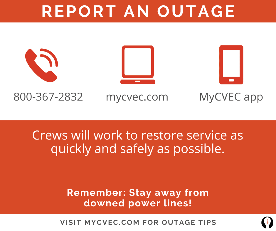
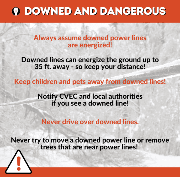
If outages occur, conditions may make it unsafe or impossible for crews to reach some areas immediately. Staying off the roads, conserving phone battery, and avoiding downed power lines helps protect both you and those working to restore service.
We are proud to serve this community, and we take that responsibility seriously. We are in this together, and by preparing ahead of time and looking out for one another, we can weather this storm as safely as possible.
We will continue to share updates as conditions evolve. Thank you for being proactive, patient, and part our Cooperative family.
Stay safe,
Your CVEC Team”
At Wintergreen, Fire & Rescue Chief Curtis Sheets is preparing homeowners there to expect the worst from subzero temperatures that will happen as the storm winds down at the end of the weekend headed into Monday. “With the super-low temps we’re about to experience, 1-3 homes at Wintergreen will freeze. Once the temps finally get back up to around 45-50, the frozen pipes will thaw and water will begin to flow. Because the homes are unoccupied, the water will flow freely until it creates icy formations on the exterior when temps drop below freezing at night. 50,000 to 100,000 gallons of water will flow through the home. There will be mold concerns, and sometimes the weight of the water and ice can even cause structural concerns. Either way, it takes months to resolve.” Sheets adds that homeowners are responsible for any damage should that happen.
Chief Sheets says now is the time to act since the worst of the weather doesn’t arrive until late Saturday afternoon through Sunday night. The temps are below freezing in the mountains as well as the valley for at least a week. “If you are able to turn the water off to your unoccupied home, do so. If you can drain your plumbing, do so. If you can find someone to periodically check on the temperatures in your home, do so.”

Meanwhile VDOT Staunton is preparing people for the fact it may take several days to remove snow and ice from the roadways once the storm has hit.
“At least a foot of snow is expected to fall on the Shenandoah Valley and Alleghany Highlands Saturday afternoon through early Monday. Stay off the roads during this time period – instead, get to your destination before the storm. Plowing operations focus on interstates and primary routes first, and may not reach all secondary roads and subdivisions for several days.
The Virginia Department of Transportation is pre-treating major roadways today and Friday throughout the 11-county Staunton District. When snowfall begins on Saturday, VDOT crews and contractors will use more than 1,100 pieces of equipment to plow and treat state-maintained roadways in the district. They will work around the clock on rotating 12-hour shifts.
The weekend storm is expected to bring heavy snow, hampering visibility and requiring plows to make multiple passes on interstates and primary roads until snowfall tapers off. Additional hazards include extreme cold during and after the storm, which minimizes melting and extends recovery time. Motorists may not see bare pavement for many days after the storm begins.
For emergency travel information visit the 511 Virginia website, or download the mobile app or call 511. Motorists are reminded to check their entire route as conditions will vary throughout Virginia. Southern portions of the Commonwealth are expected to receive less snow but more ice accumulation.
The VDOT Customer Service Center operates 24/7 to help roadway users report potential hazards, make service requests or get information related to Virginia’s transportation network. Use its mobile friendly websiteor call 800-367-7623.
The VDOT Staunton District serves Frederick, Shenandoah, Clarke, Warren, Page, Rockingham, Augusta, Highland, Rockbridge, Alleghany and Bath counties. Follow the Staunton District on Facebook and X.”
The VDOT website has winter weather travel tips, news releases, and links to social media accounts for VDOT districts throughout the Commonwealth.
Other VDOT offices in the area are echoing the same thing and are urging drivers to be prepared and expect major delays for perhaps several days.
I’ll be updating through the entire storm both here on our website and on our Facebook page, here. Feel free to post your photos over there.

Also you can hear my weather updates on the hour over at WTON Radio out of Staunton. The have towers in Staunton, Harrisonburg, and Crozet. Here’s a link to their online player as well so you can listen from anywhere.
