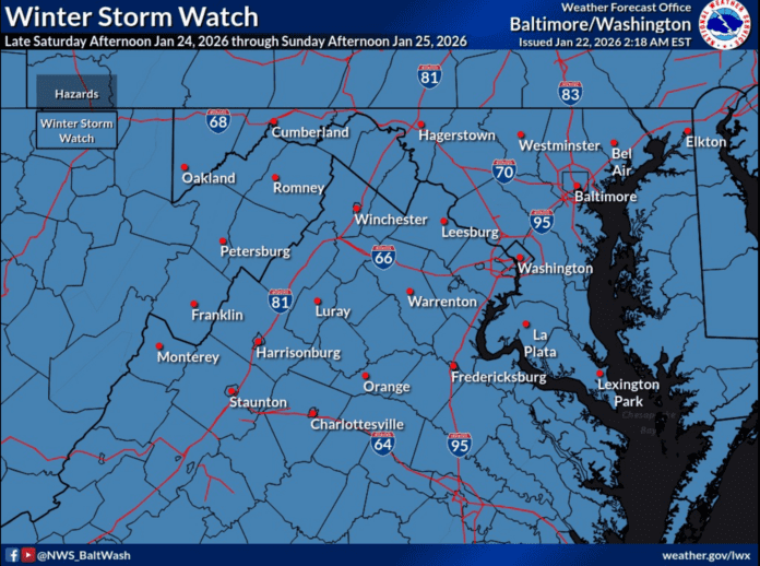
WINTER STORM WATCH
Central Virginia Blue Ridge Area
By Tommy Stafford
As I talked about yesterday, Winter Storm Watches were starting to be issued for parts of the area Wednesday afternoon. As of Thursday morning virtually all of the area is now under a Winter Storm Watch for the upcoming weekend. (Scroll down below for watch details) Some areas will stay in that watch until Monday afternoon. Look for these watches to be upgraded to Winter Storm Warnings as we get closer to the event. By Friday afternoon at the latest.
Big concerns now for a significant icing event across Central & Southern Virginia. What likely starts at snow late in the day Saturday will transition to sleet and freezing rain overnight Saturday into Sunday.
I’ll be updating information through the weekend as things change.
Tommy
URGENT – WINTER WEATHER MESSAGE
National Weather Service Baltimore MD/Washington DC
216 AM EST Thu Jan 22 2026
…MAJOR WINTER STORM POSSIBLE THIS WEEKEND…
.A large area of precipitation will overrun Arctic air in place over
the Mid-Atlantic. This will likely lead to widespread significant
snow beginning late Saturday, with the potential for ice Sunday
especially south of Highway 50 and near and east of Interstate 95.
In addition to the high threat for significant snow and ice, very
cold temperatures are expected Friday night through the middle of
next week with sub-zero wind chills likely at times.
Washington-Frederick MD-Carroll-Northern Baltimore-Northwest
Montgomery-Northwest Howard-Northwest Harford-Augusta-Rockingham-
Shenandoah-Frederick VA-Page-Warren-Clarke-Nelson-Albemarle–
Greene-Madison-Rappahannock-Orange-Culpeper-Northern Fauquier-
Southern Fauquier-Western Loudoun-Eastern Loudoun-Northern
Virginia Blue Ridge-Central Virginia Blue Ridge-Northwest Prince
William-Hampshire-Morgan-Berkeley-Jefferson-Hardy-
216 AM EST Thu Jan 22 2026
…WINTER STORM WATCH IN EFFECT FROM SATURDAY AFTERNOON THROUGH LATE
SUNDAY NIGHT…
* WHAT…Heavy snow mixed with sleet and freezing rain possible.
There is a high likelihood of at least 5 inches of snow, with over
10 inches possible. Ice accumulation is also possible, especially
south of Interstate 70.
* WHERE…Portions of central, north-central, and northern Maryland,
central, northern, northwest, and western Virginia, and eastern
West Virginia.
* WHEN…From Saturday afternoon through late Sunday night.
* IMPACTS…Travel could be very difficult.
* ADDITIONAL DETAILS…Snow will likely overspread the area by
Saturday evening, becoming heavy at times Saturday night with
rates of one to two inches per hour possible at times. A mix with
sleet or freezing rain is possible Sunday, especially south of
Interstate 70. Significant icing is possible especially across
central Virginia. Visibility of one-quarter mile or less is
possible at times. A prolonged period wind chills in the teens and
single digits is likely beginning Friday evening and lasting
through the middle of next week, with sub-zero wind chills
possible at times.
PRECAUTIONARY/PREPAREDNESS ACTIONS…
Monitor the latest forecasts for updates on this situation. Now is
the time to make preparations for the storm. This includes getting
any necessary groceries or medicines that you may not be able to
access this weekend into early next week due to any potential
closure. Have an emergency kit in the car including extra batteries,
a flashlight, and blanket just in case you get stranded. Make sure
to refuel or charge your car before the storm hits. Check on elderly
friends, family, and neighbors and don`t forget about pets or
livestock during this prolonged cold period.
URGENT – WINTER WEATHER MESSAGE
National Weather Service Blacksburg VA
959 PM EST Wed Jan 21 2026
Ashe-Alleghany NC-Surry-Stokes-Rockingham-Caswell-Watauga-Wilkes-
Yadkin-Tazewell-Smyth-Bland-Giles-Wythe-Pulaski-Montgomery-
Grayson-Carroll-Floyd-Craig-Alleghany VA-Bath-Roanoke-Botetourt-
Rockbridge-Patrick-Franklin-Bedford-Amherst-Henry-Pittsylvania-
Campbell-Appomattox-Buckingham-Halifax-Charlotte-Mercer-Summers-
Monroe-Eastern Greenbrier-Western Greenbrier-
Including the cities of West Jefferson, Danville, Quinwood,
Volney, Keysville, Hinton, Boone, Amherst, Flat Top, Appomattox,
Clifton Forge, Stuart, Hix, Tazewell, Danbury, Marion, Roanoke,
Buena Vista, Yanceyville, Wytheville, Hot Springs, Yadkinville,
Blacksburg, Dobson, Independence, Floyd, New Castle, Salem,
Bedford, Martinsville, Pulaski, Lexington, Pearisburg, Rainelle,
Lewisburg, Bland, Lynchburg, Covington, Alderson, South Boston,
Radford, Galax, White Sulphur Springs, Eden, Rocky Mount, Union,
Duo, Fincastle, Bluefield, Wilkesboro, Troutdale, Sparta, and
Whitetop
959 PM EST Wed Jan 21 2026
…WINTER STORM WATCH REMAINS IN EFFECT FROM SATURDAY MORNING
THROUGH MONDAY AFTERNOON…
* WHAT…Heavy mixed precipitation. Mainly snow and possibly sleet
along and north of U.S. 460, and snow, sleet and freezing rain
south of U.S. 460.
* WHERE…Southwest Virginia, Southeast West Virginia and Northwest
North Carolina.
* WHEN…From Saturday morning through Monday afternoon.
* IMPACTS…Winds and weight of snow or ice on tree limbs may down
power lines and could cause power outages. Travel could be very
difficult to impossible.
PRECAUTIONARY/PREPAREDNESS ACTIONS…
Monitor the latest forecasts for updates on this situation.
You should consider delaying all travel this weekend.
If travel is absolutely necessary, drive with extreme caution.
Consider taking a winter storm kit along with you, including such
items as tire chains, booster cables, flashlight, shovel, blankets
and extra clothing. Also take water, a first aid kit, and anything
else that would help you survive in case you become stranded.

