
This post has been updated : The newer version as of Thursday morning can be found by clicking this link :
https://blueridgelife.com/2026/01/22/winter-storm-watch-issued-for-entire-area-this-weekend/
WINTER STORM WATCH IN EFFECT FROM SATURDAY MORNING THROUGH MONDAY AFTERNOON
Central Virginia Blue Ridge
By Tommy Stafford
As we’ve been discussing on our Facebook page for several days now, a potent and highly significant winter storm appears to be taking shape for coming weekend. Here in the Blue Ridge, and across a large part of the country including the mid-south and the Carolinas.
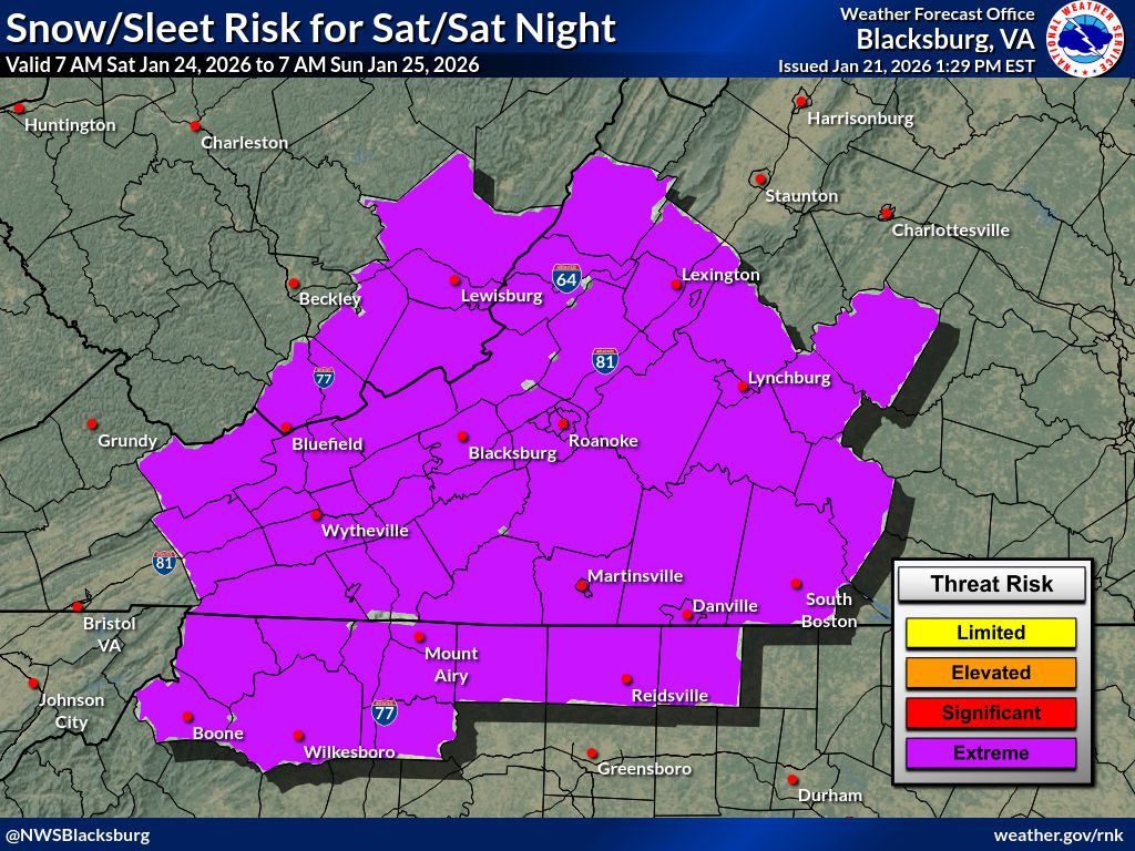
As of Wednesday afternoon, the NWS in Blacksburg has already issued their Winter Storm Watch that begins Saturday morning through Monday afternoon of next week. Forecasts of 8-14 inches of winter precipitation are projected. (details on down below)
NWS Baltimore / DC has not issued any winter storm products as of 2:45 PM Wednesday afternoon, but they will certainly follow in the not too distant future. (it will be updated on this site once that happens – auto alerts are also displayed on our homepage here and our Facebook page 24/7) Their weather office covers Nelson County and many others north of there into the DC area, including parts of WV.
Here’s the verbatim Winter Storm Watch from Blacksburg immediately below.
URGENT – WINTER WEATHER MESSAGE
National Weather Service Blacksburg VA
1244 PM EST Wed Jan 21 2026
Ashe-Alleghany NC-Surry-Stokes-Rockingham-Caswell-Watauga-Wilkes-
Yadkin-Tazewell-Smyth-Bland-Giles-Wythe-Pulaski-Montgomery-
Grayson-Carroll-Floyd-Craig-Alleghany VA-Bath-Roanoke-Botetourt-
Rockbridge-Patrick-Franklin-Bedford-Amherst-Henry-Pittsylvania-
Campbell-Appomattox-Buckingham-Halifax-Charlotte-Mercer-Summers-
Monroe-Eastern Greenbrier-Western Greenbrier-
Including the cities of Danbury, Pulaski, Marion, Wytheville, Hot
Springs, Hinton, Covington, Blacksburg, Rainelle, Duo, Quinwood,
Floyd, Amherst, New Castle, Lexington, Union, Lewisburg,
Alderson, Whitetop, Stuart, Roanoke, Yadkinville, Yanceyville,
Appomattox, Volney, Troutdale, Bluefield, Fincastle, Sparta,
Rocky Mount, Hix, Independence, Salem, Buena Vista, Danville,
Clifton Forge, Eden, Galax, Lynchburg, Boone, Radford, Flat Top,
Bedford, Tazewell, Dobson, Martinsville, Keysville, Bland,
Wilkesboro, South Boston, West Jefferson, White Sulphur Springs,
and Pearisburg
1244 PM EST Wed Jan 21 2026
…WINTER STORM WATCH IN EFFECT FROM SATURDAY MORNING THROUGH MONDAY
AFTERNOON…
* WHAT…Heavy snow possible. Total snow and sleet accumulations
between 8 and 14 inches possible.
* WHERE…Portions of north central and northwest North Carolina,
central, south central, southwest, and west central Virginia, and
southeast West Virginia.
* WHEN…From Saturday morning through Monday afternoon.
* IMPACTS…Travel could be very difficult to impossible. The
hazardous conditions could impact the Monday morning commute.
PRECAUTIONARY/PREPAREDNESS ACTIONS…
Monitor the latest forecasts for updates on this situation.
Persons are urged to stay indoors until conditions improve. If you
must go outside, dress in layers. Several layers of clothes will
keep you warmer than a single heavy coat. Cover exposed skin to
reduce your risk of frostbite or hypothermia. Gloves, a scarf, and a
hat will keep you from losing your body heat.
Persons should consider delaying all travel. Motorists should use
extreme caution if travel is absolutely necessary.
Persons should consider delaying all travel. If travel is absolutely
necessary, drive with extreme caution. Consider taking a winter
storm kit along with you, including such items as tire chains,
booster cables, flashlight, shovel, blankets and extra clothing.
Also take water, a first aid kit, and anything else that would help
you survive in case you become stranded.
