
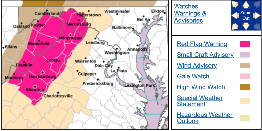
RED FLAG WARNING
URGENT – FIRE WEATHER MESSAGE
National Weather Service Baltimore MD/Washington DC
334 PM EST Tue Nov 4 2025
Augusta-Rockingham-Shenandoah-Frederick VA-Page-Warren-Clarke-
Eastern Highland-Northern Virginia Blue Ridge-
Central Virginia Blue Ridge-Hampshire-Hardy-Eastern Grant-
Eastern Mineral-Eastern Pendleton-
334 PM EST Tue Nov 4 2025
…RED FLAG WARNING IN EFFECT FROM 11 AM TO 6 PM EST WEDNESDAY DUE
TO A COMBINATION OF GUSTY WINDS, DRY FUELS, AND LOW RELATIVE
HUMIDITY FOR THE SHENANDOAH VALLEY AND THE EASTERN WEST VIRGINIA
PANHANDLE…
* TIMING…From 11 AM to 6 PM EST Wednesday.
* WINDS…Southwest 10 to 20 mph with gusts up to 45 mph.
* RELATIVE HUMIDITY…As low as 20 percent.
* IMPACTS…Any fire that develops will catch and spread
quickly. Outdoor burning is not recommended.
* FUEL MOISTURE…
PRECAUTIONARY/PREPAREDNESS ACTIONS…
A Red Flag Warning means that critical fire weather conditions
are either occurring now, or will shortly. A combination of
strong winds, low relative humidity, and warm temperatures can
contribute to extreme fire behavior.
Special Weather Statement
National Weather Service Baltimore MD/Washington DC
207 PM EST Tue Nov 4 2025
Washington-Frederick MD-Central and Eastern Allegany-Augusta-
Rockingham-Shenandoah-Frederick VA-Page-Warren-Clarke-Nelson-
Albemarle-Greene-Madison-Rappahannock-Orange-Culpeper-
Northern Fauquier-Eastern Highland-Western Loudoun-
Northern Virginia Blue Ridge-Central Virginia Blue Ridge-
Hampshire-Morgan-Berkeley-Jefferson-Hardy-Eastern Grant-
Eastern Mineral-Eastern Pendleton-
Including the cities of Hagerstown, Frederick, Ballenger Creek,
Cumberland, Staunton, Waynesboro, Stuarts Draft, Harrisonburg,
Strasburg, Woodstock, Mount Jackson, New Market, Winchester,
Luray, Shenandoah, Stanley, Front Royal, Berryville, Lovingston,
Charlottesville, Stanardsville, Madison, Washington, Orange,
Gordonsville, Culpeper, Warrenton, Monterey, Purcellville,
Big Meadows, Wintergreen, Romney, Paw Paw, Martinsburg,
Charles Town, Shepherdstown, Moorefield, Petersburg, Antioch,
Keyser, New Creek, Ridgeville, Russelldale, Headsville,
Fort Ashby, Brandywine, Franklin, Oak Flat, Ruddle,
and Sugar Grove
207 PM EST Tue Nov 4 2025
…ELEVATED FIRE DANGER WEDNESDAY FOR EASTERN WEST VIRGINIA,
PORTIONS OF WESTERN MARYLAND, AND MUCH OF CENTRAL AND NORTHWEST
VIRGINIA…
The combination of 10 hour fuel moistures around 10 percent,
relative humidities around 25 to 30 percent, wind gusts around 20-30
mph, and high temperatures in the upper 60s to low 70s will lead to
an increased risk for the rapid spread of wildfires on Wednesday.
This will be preceded by a night of very poor recoveries, which will
enhance dry conditions across the area, especially in the higher
elevations.
Residents and visitors are urged to properly dispose of cigarette
butts, matches, and any other flammable items in appropriate
containers. Additionally, exercise caution if operating any
equipment that could create sparks and keep vehicles off of dry
grass. Most dry grasses, dead leaves, and other tree litter could
easily ignite and spread fire quickly.
Lastly, remember to obey local burn bans. For more information about
wildfire danger, burn restrictions, and wildfire prevention and
education, please visit your state forestry on environmental
protection website.
Special Weather Statement
National Weather Service Blacksburg VA
119 PM EST Tue Nov 4 2025
Ashe-Alleghany NC-Surry-Stokes-Rockingham-Caswell-Watauga-Wilkes-
Yadkin-Tazewell-Smyth-Bland-Giles-Wythe-Pulaski-Montgomery-
Grayson-Carroll-Floyd-Craig-Alleghany VA-Bath-Roanoke-Botetourt-
Rockbridge-Patrick-Franklin-Bedford-Amherst-Henry-Pittsylvania-
Campbell-Appomattox-Buckingham-Halifax-Charlotte-
Including the cities of West Jefferson, Sparta, Dobson, Danbury,
Eden, Yanceyville, Boone, Wilkesboro, Yadkinville, Tazewell,
Marion, Bland, Pearisburg, Wytheville, Radford, Pulaski,
Blacksburg, Independence, Whitetop, Troutdale, Volney, Galax,
Floyd, New Castle, Clifton Forge, Covington, Hot Springs,
Roanoke, Salem, Fincastle, Lexington, Buena Vista, Stuart,
Rocky Mount, Bedford, Amherst, Martinsville, Danville, Lynchburg,
Appomattox, South Boston, and Keysville
119 PM EST Tue Nov 4 2025
…INCREASED FIRE DANGER ACROSS SOUTHWEST VIRGINIA AND NORTHWEST
NORTH CAROLINA WEDNESDAY…
Southwest to west winds are going to increase to 10 to 20 mph
Wednesday, with gusts 20 to 30 mph across much of the area.
Humidity levels dropping into the 30s in the afternoon along with
continued drying fuels will result in an increased danger of
wildfire spread.
Please refer to your local burn permitting authorities on whether
you can burn. If you do burn, use extreme caution since fires can
quickly get out of hand under these conditions.
