Flood Watch
National Weather Service Blacksburg VA
311 AM EDT Thu Sep 27 2018
…Flash Flooding Possible Across the Mountains into this Evening…
.A weak cold front will drift south through the area this morning
before stalling across northern North Carolina this afternoon.
Low pressure riding along the front will cause rainfall to
increase over the mountains by this afternoon with locally heavy
downpours possible. This rainfall combined with wet soil
conditions may lead to flooding of creeks and streams especially
west of the Blue Ridge into this evening.
Ashe-Alleghany NC-Watauga-Tazewell-Smyth-Bland-Giles-Wythe-
Pulaski-Montgomery-Grayson-Carroll-Floyd-Craig-Alleghany VA-Bath-
Roanoke-Botetourt-Rockbridge-Amherst-Mercer-Summers-Monroe-
Eastern Greenbrier-Western Greenbrier-
Including the cities of West Jefferson, Sparta, Boone, Tazewell,
Marion, Bland, Pearisburg, Wytheville, Radford, Pulaski,
Blacksburg, Independence, Whitetop, Troutdale, Volney, Galax,
Floyd, New Castle, Clifton Forge, Covington, Hot Springs,
Roanoke, Salem, Fincastle, Lexington, Buena Vista, Amherst,
Bluefield, Flat Top, Hinton, Hix, Union, Lewisburg,
White Sulphur Springs, Alderson, Quinwood, Duo, and Rainelle
311 AM EDT Thu Sep 27 2018
…FLASH FLOOD WATCH IN EFFECT THROUGH THIS EVENING…
The National Weather Service in Blacksburg has issued a
* Flash Flood Watch for portions of northwest North Carolina,
Virginia, and southeast West Virginia, including the following
areas, in northwest North Carolina, Alleghany NC, Ashe, and
Watauga. In Virginia, Alleghany VA, Amherst, Bath, Bland,
Botetourt, Carroll, Craig, Floyd, Giles, Grayson, Montgomery,
Pulaski, Roanoke, Rockbridge, Smyth, Tazewell, and Wythe. In
southeast West Virginia, Eastern Greenbrier, Mercer, Monroe,
Summers, and Western Greenbrier.
* Through this evening.
* Moderate to heavy rainfall may result in 1 to locally 3 inches
of rain through this evening. Spotty higher totals are also
possible if embedded heavier showers or thunderstorms occur.
* Already saturated ground combined with the heavy rainfall may
cause creeks and streams to overflow their banks resulting in
flash flooding.
PRECAUTIONARY/PREPAREDNESS ACTIONS…
A Flash Flood Watch means that conditions may develop that lead
to flash flooding. Flash flooding is a VERY DANGEROUS SITUATION.
Remember…TURN AROUND…DON`T DROWN!
You should monitor later forecasts and be prepared to take action
should Flash Flood Warnings be issued.
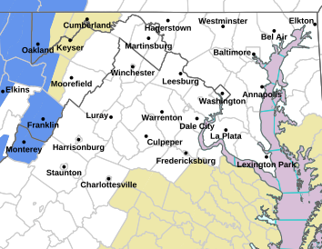
Flood Watch
National Weather Service Baltimore MD/Washington DC
239 AM EDT Thu Sep 27 2018
District of Columbia-Carroll-Northwest Montgomery-
Central and Southeast Montgomery-Northwest Howard-
Central and Southeast Howard-Nelson-Albemarle-Greene-Madison-
Orange-Culpeper-Prince William/Manassas/Manassas Park-Fairfax-
Arlington/Falls Church/Alexandria-Stafford-Southern Fauquier-
Eastern Loudoun-Central Virginia Blue Ridge-
Including the cities of Washington, Eldersburg, Westminster,
Germantown, Damascus, Bethesda, Rockville, Gaithersburg,
Silver Spring, Lisbon, Columbia, Ellicott City, Lovingston,
Charlottesville, Stanardsville, Madison, Orange, Gordonsville,
Culpeper, Dale City, Manassas, Woodbridge, Lake Ridge, Montclair,
Reston, Herndon, Annandale, Centreville, Chantilly, McLean,
Franconia, Arlington, Alexandria, Falls Church, Falmouth,
Turnbull, Leesburg, Ashburn, Sterling, and Wintergreen
239 AM EDT Thu Sep 27 2018
…FLOOD WATCH IN EFFECT FROM THIS EVENING THROUGH LATE TONIGHT…
The National Weather Service in Sterling Virginia has issued a
* Flood Watch for portions of Maryland, The District of
Columbia, and Virginia, including the following areas, in
Maryland, Carroll, Central and Southeast Howard, Central and
Southeast Montgomery, Northwest Howard, and Northwest
Montgomery. The District of Columbia. In Virginia, Albemarle,
Arlington/Falls Church/Alexandria, Central Virginia Blue
Ridge, Culpeper, Eastern Loudoun, Fairfax, Greene, Madison,
Nelson, Orange, Prince William/Manassas/Manassas Park,
Southern Fauquier, and Stafford.
* From this evening through late tonight
* A wave of low pressure will ride northeast along a stalled
front later today and tonight. Several inches of rain is
possible, and with the ground already saturated, flooding is
possible.
PRECAUTIONARY/PREPAREDNESS ACTIONS…
A Flood Watch means there is a potential for flooding based on
current forecasts.
You should monitor later forecasts and be alert for possible
Flood Warnings. Those living in areas prone to flooding should be
prepared to take action should flooding develop.


