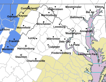
THIS WATCH HAS BEEN UPDATED AS OF 12:01 SUNDAY AFTERNOON TO INCLUDE SOME CENTRAL VA LOWLAND COUNTIES.
Here are the latest advisories / warnings from NWS
WINTER STORM WATCH
URGENT – WINTER WEATHER MESSAGE
National Weather Service Baltimore MD/Washington DC
752 PM EST Sat Mar 11 2017
District of Columbia-Washington-Frederick MD-Carroll-
Northern Baltimore-Southern Baltimore-Prince Georges-Anne Arundel-
Northwest Montgomery-Central and Southeast Montgomery-
Northwest Howard-Central and Southeast Howard-Northwest Harford-
Southeast Harford-Shenandoah-Frederick VA-Page-Warren-Clarke-
Madison-Rappahannock-Culpeper-
Prince William/Manassas/Manassas Park-Fairfax-
Arlington/Falls Church/Alexandria-Stafford-Northern Fauquier-
Southern Fauquier-Western Loudoun-Eastern Loudoun-
Northern Virginia Blue Ridge-Central Virginia Blue Ridge-
Hampshire-Morgan-Berkeley-Jefferson-Hardy-
752 PM EST Sat Mar 11 2017
…WINTER STORM WATCH IN EFFECT FROM MONDAY EVENING THROUGH
TUESDAY AFTERNOON…
The National Weather Service in Baltimore MD/Washington has
issued a Winter Storm Watch, which is in effect from Monday
evening through Tuesday afternoon.
* PRECIPITATION TYPE…Snow.
* ACCUMULATION…Potential for 5 or more inches of snow within 12
hours. Some locations may see significantly higher accumulation.
* TIMING…Snow will overspread the area Monday evening and
persist into Tuesday.
* IMPACTS…The heavy snow may make many roads impassable and may
produce power outages due to the weight of the snow on tree
limbs and power lines.
* WINDS…Northeast 10 to 15 mph with gusts up to 25 mph.
* TEMPERATURES…In the lower 30s.
PRECAUTIONARY/PREPAREDNESS ACTIONS…
A Winter Storm Watch means there is a potential for significant
snow, sleet, or ice accumulations that may impact travel.
Continue to monitor the latest forecasts.


