REFRESH Nelson County Life Magazine HERE for the latest updates:

Photography by Tommy Stafford
Nelson County Life Magazine : Copyright 2007
Cleaning the fountain @ The Mark Addy
Nellysford, Virginia
With all of the hot days we’ve had recently, this seems like the perfect place to hang out, in the fountain at The Mark Addy Inn in Nellysford. Remember Jimbo, far left, he’s the man we told you about on page 34 of the current issue of NCL . In the fountain pond is Rafael Tal. He and his wife Leslie own of The Mark Addy. Rafi was out cleaning the filter in his fountain the day we grabbed this shot. If you’ve never been by there to eat or stay, check it out. Rafi is quite the chef!! You’ll want to hang out in a pond or stream today, it’s going to be a hot and muggy one again!
Wednesday was forecast to be a stormy afternoon, but after all was said and done, nothing happened. I missed this one by a country mile folks! The only thing good I can say is all of the educated professional science types in the NWS did too! A frontal boundary that’s been in the area for most of the week moved back to our north away from us, so we were left with partly cloudy skies, hot temps, but nothing to really get afternoon thunderstorms going in our immediate area.
Here’s the numbers from Wednesday:
*NCL-Nelson County Life Magazine – Greenfield
High: 94.3 degrees @ 4:36 PM
0.00″ of rain
*NCL-Wintergreen Nature Foundation @ Devil’s Knob
High: 77.5 degrees @ 1:44 PM
0.00″ of rain
*NCL-Tiger Fuel – Lovingston
High: 91.2degrees @ 4:18 PM
0.00″ of rain
The current surface map continues to show a frontal boundary to our north. As long as it’s in the area, scattered afternoon thunderstorms will be possible. Some could become strong to severe.
Current-Sat Surface Map

The National Forecast Map, shows the front very slow to move through Nelson. A Bermuda high continues to pump warm and air into our region on southwesterly winds. Over the next 36 hours the front moves through the area bringing cooler drier air for the weekend.
Today’s Forecast Map

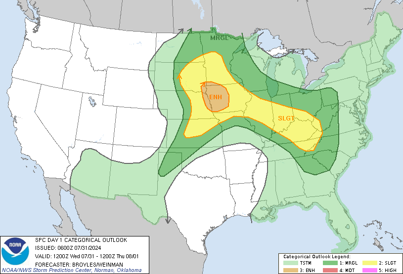
The Storm Prediction Center has us on the far southern fringe of the slight risk area for severe weather later today, the green outline.

A portion of their thinking for the Ohio Valley and areas near:
DEEP SHEAR OF 30 TO 35 KT WILL BE
SUFFICIENT FOR ORGANIZED MULTICELLS AND POSSIBLY SOME SUPERCELL
STRUCTURES. STORMS SHOULD REDEVELOP AND INTENSIFY MOST LIKELY ALONG
PRE-FRONTAL OUTFLOW BOUNDARIES. DAMAGING WIND SHOULD BE THE MAIN
THREAT…BUT THE STRONGER STORMS MAY ALSO BECOME CAPABLE OF
PRODUCING HAIL.
Local forecast
*Today Partly cloudy this morning with spotty fog burning off by mid morning. Very hot & humid with Scattered thunderstorms (some possibly severe) in the afternoon across 30% of the area. Heat index around 101 this afternoon.
*High temps in Nellysford, Hickory Creek, and Cub Creek 95 degrees.
*On the mountains above 2000 feet along the BRP, Wintergreen, Three Ridges, Devil’s Knob, and Love, Partly sunny warm and humid with scattered afternoon thunderstorms.
Highs top out around 83 degrees.
Winds SW 5-10 MPH
*Tonight Mostly cloudy, muggy & warm with thunderstorms in the evening over 50% of the area. Patchy fog in any areas that get rain.
*Lows valley around 71 degrees.
*On the mountains overnight low of 68.
*Winds SW-5 MPH.
*In the extended outlook
Friday Partly sunny with widely scattered afternoon thunderstorms over 30% of the area. Slightly cooler.
Highs around 85 valley – Mostly cloudy mountains with scattered thunderstorms
High around 78. Overnight lows generally in the upper 50’s valley and mid 50’s mountains.
The weekend looks mostly sunny and mild with afternoon highs in the low 80’s valley, mid & upper 70’s mountains. Overnight lows upper 50’s valley – low & mid 50’s mountains.
Remember when severe weather or news breaks out, come here. We’ll have all of the latest watches, warnings, and coverage affecting Nelson County, Wintergreen, and nearby counties.
Have a great Thursday!
Know your Nelson
-T-

